


Mori Atlas logo
Protected areaMarismas Nacionales–San Blas mangroves

Explore the expansive alluvial wetlands and tidal lagoon systems of the Pacific coastal plains.

Marismas Nacionales–San Blas Mangroves: A Mapped Protected Area in Coastal Western Mexico

Marismas Nacionales–San Blas mangroves represent one of the most extensive estuarine wetland systems along the Pacific coast of Mexico. Stretching through the alluvial plains of Nayarit, this protected landscape connects major river deltas with complex tidal channels and brackish lagoons. The region serves as a critical geographic junction where sediment-rich river networks meet the Pacific, forming a diverse mosaic of forest cover and coastal habitats.

mangrovescoastal wetlandslagoonsRamsar Wetlandbiosphere reservemigratory birds
A stylized illustration showing a vibrant mangrove swamp in the foreground, with water, green trees, and white wading birds, against a background of mountains and a rising sun in a pastel sky.

Marismas Nacionales–San Blas mangroves

Protected area

Park overview

Structured park overview, official facts, and landscape profile for Marismas Nacionales, San Blas mangroves

Marismas Nacionales, San Blas mangroves park facts, protected area profile, and essential visitor context

Review the core facts for Marismas Nacionales, San Blas mangroves, including designation, size, terrain, visitor scale, habitats, and operating context in one park-focused overview.

About Marismas Nacionales, San Blas mangroves

The Marismas Nacionales–San Blas mangroves are a mangrove ecoregion of the Pacific coast of Mexico, situated where the states of Sinaloa and Nayarit meet the ocean. The name combines a long-standing reference to the national marshes of the region with the southern San Blas mangrove complex, together forming one continuous coastal wetland system. The landscape is shaped by river deltas and low-lying coastal plains, with sandy beach ridges creating a natural barrier between the lagoons and the Pacific Ocean.

Ecologically, the ecoregion reflects a transitional zone between tropical dry forest influences and the more humid conditions found further south on the Mexican Pacific. It hosts the full suite of mangrove species typical of the region, with shifts in dominance from black mangroves near Teacapán in the north to white mangroves near Agua Brava in the south. Beyond the mangroves themselves, the associated floodplains, river channels, and lagoon margins broaden the habitat base for the area's wildlife.

Conservation recognition has come both from its formal designation as a Ramsar Wetland of international importance and from its inclusion within the Marismas Nacionales Biosphere Reserve. The area's ecological significance is compounded by its role as a refuge for large mammals and as a critical stopover and wintering site for migratory birds. At the same time, its location near developing coastal zones means that conservation outcomes in the ecoregion are closely tied to broader land-use decisions along Mexico's Pacific coast.

Quick facts and research context for Marismas Nacionales, San Blas mangroves

The Marismas Nacionales–San Blas mangroves occupy around 2,000 square kilometers along the Pacific coast of Mexico, spanning the coastal portions of Sinaloa and Nayarit. The ecoregion is classified within the Neotropical biogeographic realm and the mangroves biome, and borders the Sinaloan dry forests to the east. Its central feature is the Agua Brava Lagoon, with the Teacapán Lagoon to the north and the San Blas mangroves forming the southern extent. The Marismas Nacionales area was designated as a Ramsar Wetland in 1995 under the name Marismas Nacionales, and the broader landscape continues to hold critical biodiversity value for both resident and migratory species.

Protection and recognition

Documented conservation scope and 1995 establishment timeline records

Marismas Nacionales San Blas Mangroves Protection Status and Designation History

Marismas Nacionales San Blas mangroves protection status details documented management frameworks and mixed governance scopes established in 1995. Official recognition records provide foundational data for tracking the conservation history and administrative classification of the protected area.

Protection details

Protection scope
Mixed
Designated year
1995
Transboundary protection
No
Park context

Deeper park guide and search-rich context for Marismas Nacionales, San Blas mangroves

Marismas Nacionales, San Blas mangroves history, landscape, wildlife, and travel context

Explore Marismas Nacionales, San Blas mangroves through its history, landscape character, ecosystems, wildlife, conservation priorities, cultural context, and seasonal travel timing in a structured park guide built for atlas discovery and search intent.

Why Marismas Nacionales, San Blas mangroves stands out

The ecoregion is best known for its vast and relatively intact Pacific mangrove forests and its exceptionally rich birdlife, including over 250 recorded bird species. It is one of Mexico's most important wintering areas for migratory shorebirds and waterfowl along the Pacific Flyway, and is also notable for hosting large mammals such as jaguar and ocelot that still persist in coastal wetland settings. The combination of extensive mangrove cover, protected lagoons, and Ramsar recognition makes it a landmark wetland region in western Mexico.
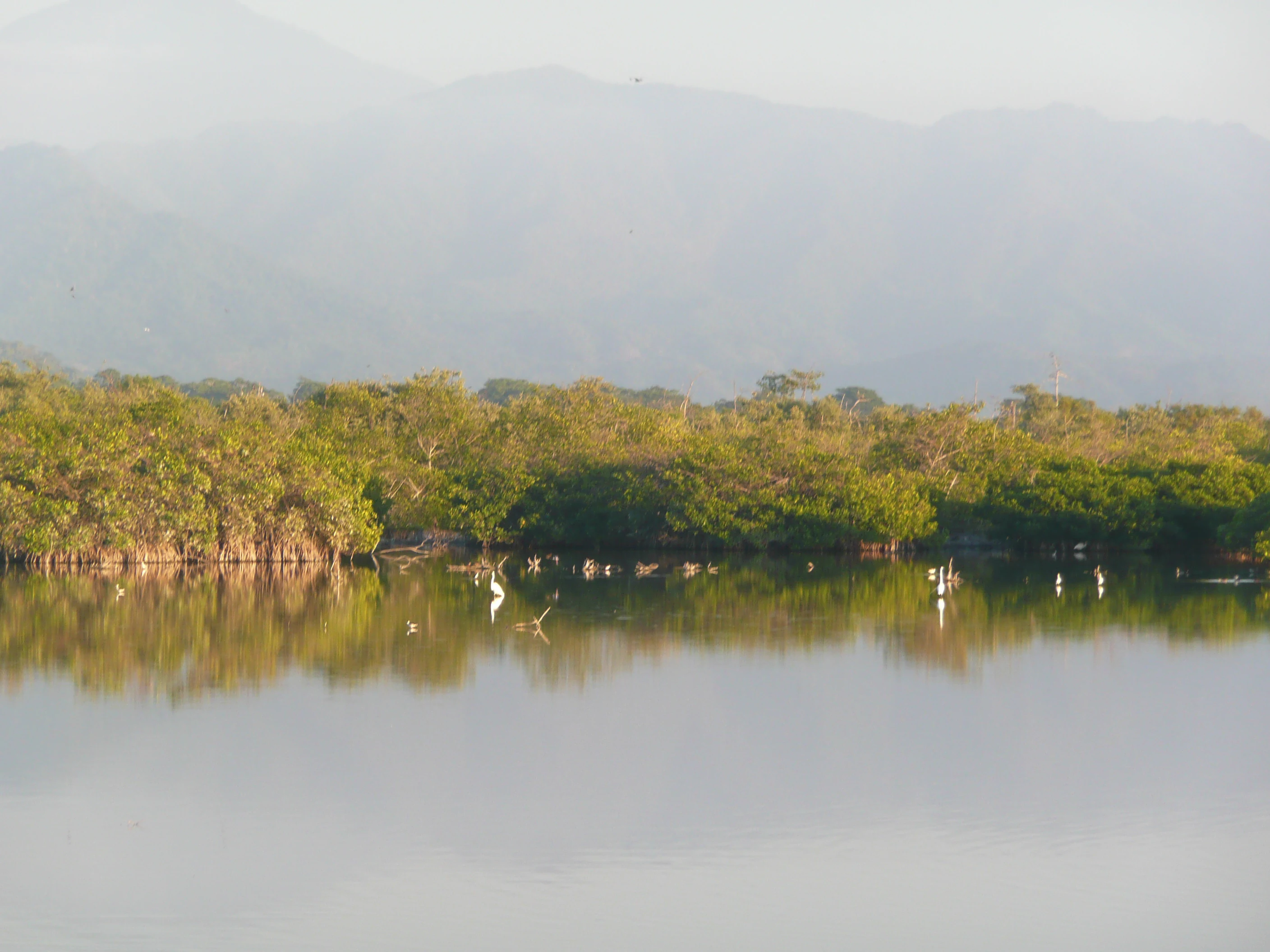
A calm, reflective body of water in the foreground, with dense green mangrove forests along the bank and hazy, distant hills in the background.
A peaceful view of the La Tovara spring, highlighting the characteristic mangrove ecosystem within the Marismas Nacionales area.

Marismas Nacionales, San Blas mangroves history and protected-area timeline

The Marismas Nacionales area has long been recognized as a nationally significant wetland landscape in Mexico, lending the region the descriptive name that translates roughly as "national marshes." The broader wetland complex has supported traditional fishing and coastal livelihoods in Nayarit and Sinaloa for generations, with communities adapting to the rhythms of lagoon fisheries, estuarine channels, and seasonal flooding.

A major formal milestone came on 22 June 1995, when the core area known as Marismas Nacionales was designated as a Ramsar Wetland of international importance, reference number 732. This designation underscored the global value of the marshes for waterbirds, biodiversity, and wetland conservation. More recent institutional history has involved the protection of the area within the Marismas Nacionales Biosphere Reserve framework, reinforcing its status as a nationally protected landscape.

Since 2009, the Mexican tourism investment office Fonatur has been planning a very large-scale tourism development adjacent to Marismas Nacionales, including thousands of hotel and vacation home rooms, multiple golf courses, marinas, and supporting urbanization. This planning has placed the wetlands at the center of national debates over coastal development, conservation policy, and the future of mangrove ecosystems on Mexico's Pacific coast.

Marismas Nacionales, San Blas mangroves landscape and geographic character

The physical landscape of the Marismas Nacionales–San Blas mangroves is defined by a broad, low-lying alluvial coastal plain through which several major rivers spill into the Pacific Ocean. The Acaponeta, San Pedro Mezquital, and Grande de Santiago rivers have built up sediment over time, creating expansive wetlands that sit behind a chain of sandy beach ridges. These ridges function as natural barriers between the calm, sheltered lagoon system and the more energetic Pacific shoreline.

The central Agua Brava Lagoon and the northern Teacapán Lagoon are the principal water bodies of the complex, and together they anchor the wetland mosaic that defines the ecoregion. South of the Grande de Santiago river mouth, the San Blas mangroves continue the chain of tidal channels, estuarine forests, and brackish lagoons. Additional mangrove formations lie to the north and adjacent to the main complex, including the Presidio River delta, the Baluarte River delta, and the Urías estuary near Mazatlán, framing the broader coastal wetland landscape of northwestern Mexico.

Marismas Nacionales, San Blas mangroves ecosystems, habitats, and plant life

Ecologically, the Marismas Nacionales–San Blas mangroves represent one of the most extensive and well-developed mangrove systems on Mexico's Pacific coast. Four primary mangrove species shape the vegetation, with distinct shifts in dominance that reflect local hydrology, salinity, and sediment patterns. Black mangrove tends to dominate in the northern Teacapán area, while white mangrove becomes more prominent around the central Agua Brava Lagoon.

Beyond the mangroves themselves, the wetland complex supports a richer mosaic of associated habitats, including tidal channels, brackish lagoons, freshwater margins, and riparian zones along the contributing rivers. Trees such as ciruelillo, zapotón, and anona grow in association with the mangrove stands, adding vertical structure to the forests and broadening habitat diversity. The interface between mangrove, open water, beach ridge, and adjacent Sinaloan dry forests creates strong ecological gradients over relatively short distances, supporting a wide range of species.

Marismas Nacionales, San Blas mangroves wildlife and species highlights

Wildlife is one of the defining features of the Marismas Nacionales–San Blas mangroves, with the area hosting more than 250 recorded bird species and serving as a vital winter habitat for migratory birds traveling along the Pacific Flyway. The combination of mangroves, lagoons, estuaries, and open water creates varied feeding and roosting conditions for shorebirds, wading birds, and waterfowl, while surrounding forests and scrub provide habitat for resident bird communities.

The Marismas Nacionales Biosphere Reserve also supports a notable suite of mammals, including deer, jaguar, ocelot, and lynx. The persistence of these typically forest- and range-associated predators within a coastal wetland context is unusual and highlights the size and habitat heterogeneity of the protected landscape. Aquatic and reptilian life typical of mangrove estuaries, along with seasonal concentrations of migratory species, reinforce the area's value as a year-round wildlife refuge.

Marismas Nacionales, San Blas mangroves conservation status and protection priorities

The Marismas Nacionales–San Blas mangroves hold considerable conservation significance at both national and international levels. The Marismas Nacionales area was designated as a Ramsar Wetland in 1995, recognizing its importance for waterbirds, ecological representativeness, and overall wetland values. The landscape is further protected within the Marismas Nacionales Biosphere Reserve, adding layers of environmental regulation and ecological management to its formal status.

Beyond legal designations, the conservation importance of the ecoregion lies in its scale, its near-complete representation of mangrove types, and its function as habitat for migratory birds and large mammals. Almost all of the globally recognized mangrove species are present, along with diverse associated tree species. Conservation concern, however, remains high: a major tourism development planned since 2009 by Fonatur envisions tens of thousands of hotel rooms, golf courses, marinas, commercial centers, and a supporting worker city. The direct habitat loss and indirect pressures from such a development pose substantial risks to the mangrove ecosystem and the species that depend on it.

Top sights and standout views in Marismas Nacionales, San Blas mangroves

The Marismas Nacionales–San Blas mangroves stand out for combining vast mangrove extent, exceptional bird diversity, and protected status along Mexico's Pacific coast. The ecoregion links multiple major river deltas, two principal lagoon systems, and the southern San Blas mangroves into a coherent coastal wetland landscape. It holds both Ramsar Wetland recognition and biosphere reserve protection, yet remains at the center of ongoing development pressure, making it a focal point for wetland conservation policy in Mexico.

Park location guide

Geography guide, regional context, and park location map for Marismas Nacionales, San Blas mangroves

Marismas Nacionales, San Blas mangroves park geography, regions, and map view in Mexico

Understand where Marismas Nacionales, San Blas mangroves sits in Mexico through a broader geographic reading of the surrounding landscape, nearby location context, and its mapped position within the national park landscape.

How Marismas Nacionales, San Blas mangroves fits into Mexico

Mexico, officially the United Mexican States, is a country in North America spanning the Sierra Madre mountain ranges, coastal plains, and tropical regions. It borders the United States to the north, Guatemala and Belize to the southeast, and has coastlines along the Pacific Ocean, Gulf of Mexico, and Caribbean Sea. With a population exceeding 130 million, Mexico is home to one of the world's most significant concentrations of Indigenous languages alongside Spanish.

Wider geography shaping Marismas Nacionales, San Blas mangroves in Mexico

Mexico occupies a land area of 1,972,550 km2, making it the thirteenth-largest country in the world. The terrain is highly diverse, featuring the Sierra Madre Occidental and Sierra Madre Oriental mountain ranges, the Mexican Plateau, coastal lowlands along the Pacific and Gulf/Caribbean margins, and the Yucatan Peninsula. The country spans multiple climate zones from desert in the north to tropical rainforest in the south.

Location context for Marismas Nacionales, San Blas mangroves

NayaritSinaloa

Visual exploration of estuarine lagoons, tidal channels, and Pacific mangrove habitats

Marismas Nacionales–San Blas mangroves photos, scenery, and protected landscape views

Visual documentation captures the complex terrain, expansive wetlands, and sheltered lagoon systems of Marismas Nacionales–San Blas mangroves. Examining these protected area photographs reveals the ecological character of coastal habitats along the Pacific Flyway.

A calm, reflective body of water in the foreground, with dense green mangrove forests along the bank and hazy, distant hills in the background.

Common questions about visiting, size, designation, and location context for Marismas Nacionales, San Blas mangroves

Marismas Nacionales, San Blas mangroves FAQs for park facts, access, geography, and protected area context

Find quick answers about Marismas Nacionales, San Blas mangroves, including protected-area facts, park geography, trail and visitor context, and how the park fits into its surrounding country and regional landscape.
MoriAtlas Explorer

Continue Your Protected Areas Search Across the Global Atlas

Deepen your exploration by continuing the structured search for national parks and protected areas worldwide. Utilize the comprehensive filtering capabilities to compare different conservation landscapes and refine your understanding of global park geography. Discover more about the distribution and characteristics of protected natural areas.

Global natural geography