
Mori Atlas logo
Nature reserveMorgenbachtal

A detailed geographic look at the steep cliffs, forested ravines, and cultural heritage of this German nature reserve.

Morgenbachtal: Exploring the Protected Landscapes and Slate Geography of the Middle Rhine Valley

(Naturschutzgebiet Morgenbachtal)

Morgenbachtal is a designated nature reserve located in the Binger Wald of Germany, where the crystalline slate ridges rise sharply above the Rhine. This protected valley encompasses a unique intersection of geological formations, including rugged rock faces utilized for climbing, and dense forest ecosystems. Beyond its natural terrain, the area maps out a rich historical narrative featuring Roman archaeological sites, medieval castles, and ancient woodland trails that integrate into the regional landscape.

nature reserveMiddle Rhine valleyslate cliffsrock climbing areaRhenish Slate Mountainsmixed forest
A stylized flat vector illustration of a valley featuring steep rock cliffs, a flowing waterfall, a meandering river, and pine trees.

Morgenbachtal

Nature reserve

Park overview

Structured park overview, official facts, and landscape profile for Morgenbachtal Nature Reserve

Morgenbachtal Nature Reserve park facts, protected area profile, and essential visitor context

Review the core facts for Morgenbachtal Nature Reserve, including designation, size, terrain, visitor scale, habitats, and operating context in one park-focused overview.

About Morgenbachtal Nature Reserve

Morgenbachtal is one of the smaller yet distinctive nature reserves of Rhineland-Palatinate, established in 1984 to protect a steep, forested tributary valley descending toward the Upper Middle Rhine. It lies within Landkreis Mainz-Bingen, just north of the town of Bingen and south of the village of Trechtingshausen, overlooking the Rhine where the famous river castles line the opposite and near banks.

The reserve covers about 215 hectares of the Binger Wald and the valley floor shaped by the Morgenbach. Its character is shaped by the geology of the Rhenish Slate Mountains: quartz-bearing crystalline slate forms the cliffs that rise up to roughly 40 metres in two prominent ridge lines along the western slope. Below the cliffs, mixed deciduous woodland, stream habitats, and smaller ravines create a varied micro-relief that supports a wide range of species in spite of the area's modest total extent.

What sets Morgenbachtal apart from many other slate-valley reserves is the deliberate, regulated coexistence of strict nature protection and active outdoor recreation. The 1984 protection decree explicitly preserved climbing as a permitted activity, and a long-running partnership between the state, the local municipality of Trechtingshausen, and the German Alpine Club (Sektion Mainz) maintains the trails, rock routes, and safety infrastructure. As a result, the Morgenbachtal is simultaneously a formally protected conservation area and one of the most accessible and well-used climbing landscapes in western Germany.

Quick facts and research context for Morgenbachtal Nature Reserve

Morgenbachtal is a nature reserve (Naturschutzgebiet) located in Landkreis Mainz-Bingen, Rhineland-Palatinate, along the steep western bank of the Rhine valley above Trechtingshausen. It encompasses roughly 215 hectares of forested valley terrain and was placed under formal protection by decree on 29 October 1984. The valley is drained by the Morgenbach, a left-hand tributary flowing into the Rhine, and borders the Bundesstrasse 9 corridor.

The defining physical features are quartz-bearing crystalline slate cliffs of the Rhenish Slate Mountains, which rise up to about 40 metres in height and provide both scenic value and one of the most frequented climbing grounds in the Middle Rhine region. The reserve's trail network connects the Soonwaldsteig, the Rheinburgenweg, and cultural-historical sites such as the Roman Villa rustica and the castles of Rheinstein and Reichenstein.

Protection and recognition

Documented conservation records and official protected area metrics

Morgenbachtal Protection Status and International Recognition Data

Morgenbachtal holds structured conservation data detailing official protection status, management scope, and verified designation records. Comprehensive protected area metrics and international source entries provide clear reference points for conservation geography.

Protection details

WDPA ID
164692
Park context

Deeper park guide and search-rich context for Morgenbachtal Nature Reserve

Morgenbachtal Nature Reserve history, landscape, wildlife, and travel context

Explore Morgenbachtal Nature Reserve through its history, landscape character, ecosystems, wildlife, conservation priorities, cultural context, and seasonal travel timing in a structured park guide built for atlas discovery and search intent.

Why Morgenbachtal Nature Reserve stands out

Morgenbachtal is best known for its crystalline slate rock faces, which form one of the most popular rock-climbing areas in the Rhine-Main metropolitan region and along the Middle Rhine. The cliffs, including named groups such as the Frankfurter Wand, Herkules, Mainzer Turm, and Kristallspitze, rise in two ridge-like lines up the western valley slope and offer routes suitable for both beginners and experienced climbers. Equally distinctive is the compact combination of dense valley forest, a small stream valley, and a richly layered cultural landscape. Within a relatively short distance, hikers encounter the Roman Villa rustica, the Steckeschlääferklamm gorge, the forester's lodge known as Jägerhaus, and the medieval castles Rheinstein and Reichenstein, giving the reserve an unusual blend of ecological and historical significance.
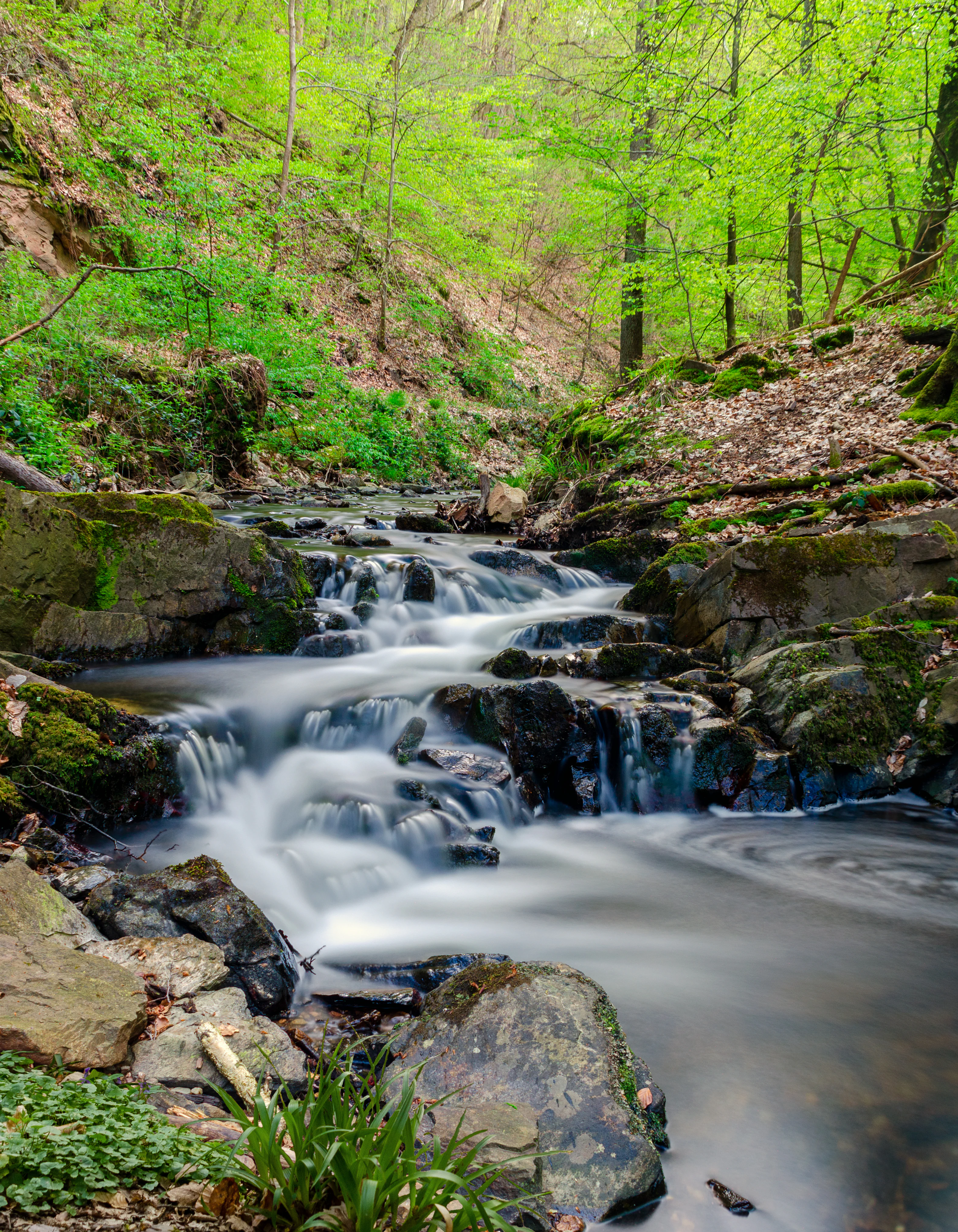
A long exposure of a stream flowing over dark, mossy rocks in a lush, green forest.
Long exposure photograph of the Morgenbach stream flowing through the forest in May.

Morgenbachtal Nature Reserve history and protected-area timeline

The Morgenbachtal was placed under formal nature protection on 29 October 1984 by decree of the state of Rhineland-Palatinate, creating the legally defined Naturschutzgebiet that exists today. Unlike many comparable reserves in other German states, the original decree explicitly permitted rock climbing, giving the valley a regulatory framework that combined conservation with recreational use from its very beginnings.

In subsequent years a structured management system was developed. The Mainz section of the German Alpine Club (DAV) entered into a usage agreement with the municipality of Trechtingshausen, took on stewardship of the area, appointed a dedicated safety officer, and arranged liability insurance to cover obligations related to terrain safety. This partnership became the backbone of day-to-day management.

A significant event in the reserve's history was a larger rockslide at the Klüverwand in February 1995. Following an initial geological assessment, Trechtingshausen temporarily banned climbing. A subsequent expert opinion concluded that the slate lies on rough underlying layers and that rock movement is gradual and predictable. From then on, mandatory annual safety inspections were introduced and climbing was allowed to resume under the new regime.

The trail network itself also has a history of restoration. After severe storm damage in 2016, the main hiking route through the valley was closed for an extended period. Funding from the municipality, the state of Rhineland-Palatinate, and federal sources eventually allowed the path to be fully restored.

Morgenbachtal Nature Reserve landscape and geographic character

The landscape of Morgenbachtal is rooted in the geology of the Rhenish Slate Mountains (Rheinisches Schiefergebirge). The valley's cliffs are formed from crystalline slate with quartz inclusions, rock that offers good climbing surfaces but is not always comfortable for friction-dependent moves. These formations give the reserve a rugged, sharply profiled appearance unusual for the otherwise rounded hills of the region.

The terrain is organised along two main ridge-like lines of cliffs that climb the western slope of the Rhine valley. In total, about ten named rock formations are recognised; from upper to lower and from south to north they include Schinderhannes, Frankfurter Wand, Regensburgerwand, Herkules, Klüverwand, Hakenrisse, Wappenwand, Mainzer Turm, Kristallspitze, and Lutzplatte. The highest walls reach approximately 40 metres.

Between the rock faces, narrow forested ravines, the incised channel of the Morgenbach, and small tributary gullies form the lower part of the landscape. The eastern edge of the reserve is bounded by the broad valley of the Rhine and the corridor of the Bundesstrasse 9, while the slopes themselves are densely covered by mixed forest typical of the Binger Wald. This juxtaposition of compact rocky gorge, wooded slope, and open river valley scenery gives the Morgenbachtal a clearly stratified and visually dramatic profile.

Morgenbachtal Nature Reserve ecosystems, habitats, and plant life

Ecologically, the Morgenbachtal functions as a small but well-structured refuge within the Binger Wald. The valley bottom, defined by the perennial flow of the Morgenbach and small side streams, creates humid micro-habitats that contrast sharply with the dry, sun-exposed rock faces above. This abrupt shift in moisture and light conditions over short distances gives the reserve a high diversity of habitat types despite its compact area.

The forests that dominate the slopes are characteristic of the western Rhenish Slate Mountains: mixed deciduous woodland with beech and oak, interspersed with conifers on less accessible terrain. The cliff faces and their associated ledges provide specialised habitats that in many other German states are closed to climbing for conservation reasons, but here are managed under an active stewardship regime that allows access while monitoring impact.

The protection order of 1984 places the entire complex under binding nature-protection rules, restricting damaging activities and securing the long-term integrity of forest, rock, and stream habitats. This formal protection, combined with daily oversight by the climbing organisations, creates a management framework where ecological recovery and recreational use are actively balanced.

Morgenbachtal Nature Reserve wildlife and species highlights

The Morgentbachtal's wildlife profile is shaped primarily by the interplay of forest, cliff, and stream habitats. The wooded slopes support the typical fauna of the Binger Wald: small mammals such as red squirrel and various bat species, while the unlogged, half-open forest edges provide important structural habitat for woodland birds. Rock faces and crevices offer nesting and refuge habitat for cliff-nesting and crevice-dwelling bird species typical of the Middle Rhine valley.

The stream environment of the Morgenbach and its small tributaries adds an aquatic component to the reserve's biodiversity, supporting invertebrates and amphibians characteristic of small, shaded Middle Rhine tributaries. Although the German Wikipedia source does not enumerate specific species, the combination of stream, cliff, and forest habitats makes the morning valley a valuable small-scale refuge for typical Middle Rhine valley fauna.

The presence of a managed climbing community also plays a role in wildlife monitoring: any unusual sightings of nesting birds, reptile activity on the rocks, or seasonal ecological concerns are factored into route closures and seasonal access regulations agreed upon between the climbing groups and conservation authorities.

Morgenbachtal Nature Reserve conservation status and protection priorities

Conservation in the Morgenbachtal is centrally defined by its 1984 protection order, which places the entire 215-hectare reserve under formal state nature protection. The decree's significance lies not only in the designation itself but also in its deliberately inclusive approach: rock climbing was expressly preserved as a permitted activity, distinguishing the area from many other German slate regions where climbing has been banned outright.

Active stewardship of the reserve is shared between the state, the municipality of Trechtingshausen, and the Mainz section of the German Alpine Club. This partnership regulates routes, monitors erosion, and maintains the trail system, providing a working model of how strict nature protection and active outdoor recreation can coexist when properly managed.

Following the 1995 rockslide at the Klüverwand, the conservation regime was tightened with mandatory annual geological safety inspections. Subsequent erosion and tread damage from heavy visitor use has been addressed through careful trail realignment work, coordinated between the DAV, local authorities, and the Landesamt für Umweltschutz (State Office for Environmental Protection), which has commissioned further studies on habitat and visitor impacts.

Morgenbachtal Nature Reserve cultural meaning and human context

Although the Morgenbachtal is primarily known as a natural and recreational landscape, it is embedded in a deeply layered cultural setting. The valley lies directly along the most castle-rich stretch of the Middle Rhine, and hiking routes through the reserve lead past the medieval castles Rheinstein and Reichenstein, both closely associated with the romantic and historic identity of the Upper Middle Rhine.

A Roman villa rustica near Weiler, just outside the reserve, is reached via the same trail network, providing direct evidence of continuous human use of the slopes going back to antiquity. The historic "Schweizerhaus" and the old forest ranger's lodge known as Jägerhaus add further cultural depth, marking the area's long tradition of forestry, hunting, and rural settlement.

The local municipality of Trechtingshausen plays an active cultural and administrative role in the valley, holding the usage agreement with the German Alpine Club and coordinating visitor management. This strong municipal involvement means the Morgentbachtal is not simply a protected inner landscape but a lived-in piece of regional identity in the Middle Rhine UNESCO setting.

Top sights and standout views in Morgenbachtal Nature Reserve

Key highlights of the Morgenbachtal include its crystalline slate cliffs, which form one of the most beloved climbing grounds of the entire Rhine-Main region and the Middle Rhine, and the valley's tightly interwoven network of hiking trails that combine the long-distance Soonwaldsteig and Rheinburgenweg into a single scenic loop.

Cultural highlights enrich the natural scenery: the medieval castles Rheinstein and Reichenstein, the Roman Villa rustica, the dramatic Steckeschlääferklamm gorge, and the historic Jägerhaus forest ranger's lodge all lie within or adjacent to the reserve. Together they make the valley a place where geology, ecology, and centuries of human history meet within a few kilometres of trail.

The combination of formal nature protection since 1984 with regulated, partnership-based recreational use is itself a defining feature. Few reserves in Germany balance strict conservation, organised climbing, and a major regional hiking network quite as visibly as the Morgenbachtal.

Best time to visit Morgenbachtal Nature Reserve

Spring and early summer are generally the most attractive seasons for experiencing the Morgenbachtal at its greenest, when the Morgenbach is flowing strongly and woodland flora is fully active. Late spring brings dense leaf cover to the deciduous slopes, increasing the contrast between cool valley forest and the exposed slate cliffs above.

Autumn is also rewarding, with cooler stable weather, soft light on the dark slate rock faces, and quieter hiking conditions. Winter visits are possible but require caution: storm damage such as that of 2016 can lead to temporary trail closures, and shorter days limit the time available for the roughly twelve-kilometre loop. Rock climbing is a year-round activity, but the cold months bring shorter rock temperatures and increased safety considerations on the slate faces.


Monthly climate preview

Long term monthly temperature and precipitation rhythm for Morgenbachtal

Morgenbachtal Climate Normals and Annual Temperature Patterns

Morgenbachtal exhibits a recorded annual temperature rhythm spanning from subzero winter minima to warm summer maximums alongside consistent monthly precipitation. Detailed monthly climate normals provide deeper insight into long term temperature variations and precipitation averages across the protected area.
Annual mean9 °C
0 °C20 °C
Jan
Feb
Mar
Apr
May13°
Jun17°
Jul20°
Aug19°
Sep15°
Oct
Nov
Dec
Warmest month
July

19.6 °C

Coolest month
January

-0.1 °C

Wettest month
July

2.2 mm/day

Driest month
April

1.5 mm/day

Park location guide

Geography guide, regional context, and park location map for Morgenbachtal Nature Reserve

Morgenbachtal Nature Reserve park geography, regions, and map view in Germany

Understand where Morgenbachtal Nature Reserve sits in Germany through a broader geographic reading of the surrounding landscape, nearby location context, and its mapped position within the national park landscape.

How Morgenbachtal Nature Reserve fits into Germany

Germany is a federal republic in Western and Central Europe with a population of over 83 million across sixteen constituent states. It is Europe's largest economy by nominal GDP and a major global exporter and importer. The capital is Berlin, and the country borders Denmark, Poland, Czech Republic, Austria, Switzerland, France, Luxembourg, Belgium, and the Netherlands.

Wider geography shaping Morgenbachtal Nature Reserve in Germany

Germany is located in Western and Central Europe, spanning 357,022 km². It borders Denmark to the north, Poland and the Czech Republic to the east, Austria and Switzerland to the south, and France, Luxembourg, Belgium, and the Netherlands to the west. The country has coastlines on the Baltic Sea and North Sea to the north, with the Alps located in the southern region.

Map view of Morgenbachtal Nature Reserve

Use this park location map to pinpoint Morgenbachtal Nature Reserve in Germany, understand its exact geographic position, and read its mapped placement within the surrounding landscape more clearly.

Pigeon | © OpenStreetMap contributors

Examine crystalline slate cliffs, dense forest habitats, and valley terrain across the reserve

Morgenbachtal Photos and Landscape Scenery: Visualizing the Protected Valley

Visual documentation captures the rugged topography of Morgenbachtal, highlighting sheer rock faces and shaded forest ravines. Studying these protected-area views reveals the distinctive geological character and dense woodland habitats shaping the Rhine valley reserve.

A long exposure of a stream flowing over dark, mossy rocks in a lush, green forest.

Park atlas

Compare adjacent river valleys, slate cliffs, and regional conservation areas

Explore Parks Near Morgenbachtal and Surrounding Protected Landscapes

Browse protected areas and forested terrain situated near Morgenbachtal to expand your geographic understanding of the Middle Rhine valley. Regional park comparison reveals connected geological formations and conservation networks across the surrounding Rhenish Slate Mountains.
A watercolor painting showing a soft, atmospheric landscape with a river flowing through green hills and gentle, misty mountains.
Nature reserveRhineland-Palatinate
About 1.4 km away#1 closest

East

Inselrhein Nature Reserve, Rhineland-Palatinate: A Geographic and Protected-Area Atlas

River islands, floodplain forests, and Upper Rhine wetlands

Inselrhein features a chain of natural river islands and side channels forming a critical wetland habitat. The terrain transition from soft-wood to hardwood forest communities creates a layered landscape. Examine the protected boundaries and geographic significance of this river corridor between Mainz and Bingen, documented within the Rhineland-Palatinate atlas.

Relief
Lowland
Climate
Temperate
Access
Easy access
Scope
Terrestrial
A horizontal watercolor painting showing a river winding through lush green islands and low hills in the background.
Nature reserveHesse
About 3.8 km away#2 closest

Northwest

Lorcher Werth Nature Reserve: Protected Rhine Island Geography and Floodplain Forest

An ecologically significant island pair in the Middle Rhine, Hesse.

Lorcher Werth is a unique river island complex in Hesse, Germany, designated as a nature reserve and European Habitats Directive site. These uninhabited islands act as a vital refuge for floodplain habitats, currently undergoing a transformation toward natural Auwald forest. This site provides a rare, flat fluvial counterpoint to the surrounding steep and narrow landscapes of the Middle Rhine corridor.

Area
0.129 km²
Relief
Lowland
Climate
Temperate
Access
Highly restricted
Watercolor painting of a river landscape with rolling green hills, distant slopes, and soft vegetation in shades of green and pink against a white background.
Nature reserveRheingau-Taunus-Kreis
About 6.1 km away#3 closest

East

Rüdesheimer Aue Nature Reserve and Upper Rhine Protected Landscape

Riverine geography and protected floodplain forest

Rüdesheimer Aue represents a rare, uninhabited island refuge along the Upper Rhine. Its geography features shifting sediment bars, mudflats, and softwood floodplain forest cover, offering an essential staging ground for migratory waterbirds within the Rheingau-Taunus district of Hesse.

Area
0.057 km²
Relief
Lowland
Climate
Temperate
Access
Remote access
A watercolor illustration of a calm body of water with a single tree in the center; distant rolling hills are visible in the background under a soft, pastel-colored sky.
Nature reserveLower Saxony
About 9.5 km away#4 closest

East

Fulder Aue, Ilmen Aue Nature Reserve: Mapped Protected Landscapes and Floodplain Geography

Alluvial river islands and wetland ecosystems in the Rhine valley.

The Fulder Aue, Ilmen Aue nature reserve serves as an vital example of an active Rhine floodplain. This area preserves a mosaic of islands, connecting channels, and soft-wood forest habitats. Learn about the geographic and hydrological dynamics that shape this protected space near Bingen am Rhein, showcasing its importance within the Rhine lowland system.

Area
3.38 km²
Established
1995
Relief
Lowland
Scope
Terrestrial
A soft, painterly watercolor illustration of a rolling landscape with patches of forest, light green fields, and distant hazy hills.
Protected landscapeRheinland-Pfalz
About 14 km away#5 closest

Southwest

Soonwald Protected Landscape: Mapped Quartzite Ridges and Forested Massifs in Rhineland-Palatinate

Geographic analysis of the Hunsrück ridge system and protected natural terrain

The Soonwald is a significant quartzite-dominated ridge system within the German Hunsrück. This protected landscape encompasses 40 kilometers of uninterrupted crestlines, deep valley incisions, and ecological forest reserves. It offers a detailed study in mountain geography and ridge-dominated topography for those interested in the structural layout of the Rhineland-Palatinate natural environment.

Area
276.6 km²
Relief
Mountain
Climate
Temperate
Access
Easy access
A horizontal watercolor painting of a river landscape with lush green trees, grasses, and a winding waterway under a soft light.
Nature reserveHessen
About 14 km away#6 closest

East

Mariannenaue Nature Reserve: Protected River Island Geography and Landscape Atlas

Rhine river island and floodplain forest in Hessen, Germany.

Mariannenaue serves as a prominent example of a protected inland island in the Upper Rhine. Its geography encompasses a complex mix of veteran floodplain forest, still-water habitats, and centuries-old vineyard cultivation. This detail page provides insights into the park boundaries, the surrounding riverine terrain, and the ecological network that connects this site to the broader Rheingau landscape.

Area
1.96 km²
Established
1972
Relief
Lowland
Climate
Temperate
Nature reserveRhein-Hunsrück-Kreis
About 15 km away#7 closest

Northwest

Struth Nature Reserve: Protected Wetland and Forest Geography in Rhein-Hunsruck-Kreis

Extensive wetland mosaic within the Hunsruck uplands

Struth is a sprawling nature reserve in Germany, known for its rare alder swamp woodlands and expansive wet meadows. Its geography reveals a transitional landscape between forested uplands and the Middle Rhine valley, offering a vital ecological corridor that includes protected habitat for threatened bat and beetle species across 871 hectares.

Area
8.71 km²
Established
1987
Relief
Upland
Scope
Terrestrial
Nature reserveRhineland-Palatinate
About 18 km away#8 closest

East

Hangflächen um den Heidesheimer Weg: Nature Reserve Geography and Protected Landscape Context

Mainz-Bingen, Rhineland-Palatinate Nature Reserve

Hangflächen um den Heidesheimer Weg contains an unusual ecological convergence of sand dunes, open flats, and calcareous grasslands near Ingelheim am Rhein. This nature reserve provides critical protection for a fragmented yet highly structured landscape where springs and wetland zones intersect with warm, dry slopes. The area preserves a significant biotope complex of national importance within the Upper Rhine Plain.

Area
3.348 km²
Established
2003

Common questions about visiting, size, designation, and location context for Morgenbachtal Nature Reserve

Morgenbachtal Nature Reserve FAQs for park facts, access, geography, and protected area context

Find quick answers about Morgenbachtal Nature Reserve, including protected-area facts, park geography, trail and visitor context, and how the park fits into its surrounding country and regional landscape.
MoriAtlas Explorer

Continue Your Protected Areas Search Across the Global Atlas

Deepen your exploration by continuing the structured search for national parks and protected areas worldwide. Utilize the comprehensive filtering capabilities to compare different conservation landscapes and refine your understanding of global park geography. Discover more about the distribution and characteristics of protected natural areas.

Global natural geography