Mori Atlas logo
National parkMount Eccles National Park

Discover the mapped terrain and protected land context of this significant Australian volcanic landscape.

Mount Eccles National Park: Protected Area Atlas and Volcanic Landscape Geography

Mount Eccles National Park represents a key protected area within the volcanic plains of western Victoria, Australia, centered on the prominent shield volcano. As part of Budj Bim National Park, its geographic scope offers insights into ancient volcanic activity and the surrounding natural terrain. This page provides detailed atlas-style exploration of its protected boundaries and regional landscape context, essential for understanding Australia's unique geographic formations.

AustraliaVictoriaVolcanic LandscapeProtected AreaFormer National ParkBudj Bim

Mount Eccles National Park

National park

Park overview

Structured park overview, official facts, and landscape profile for Mount Eccles National Park

Mount Eccles National Park park facts, protected area profile, and essential visitor context

Review the core facts for Mount Eccles National Park, including designation, size, terrain, visitor scale, habitats, and operating context in one park-focused overview.

About Mount Eccles National Park

Mount Eccles National Park is a former protected area in Victoria, Australia that has been redesignated as part of Budj Bim National Park. The park was centered around the volcanic landscape of Mount Eccles, a prominent shield volcano formed through ancient volcanic activity. This area holds significant cultural and ecological value within the volcanic plains of western Victoria.

Quick facts and research context for Mount Eccles National Park

Mount Eccles was located in western Victoria, Australia, within the volcanic plains region. The landscape was characterized by volcanic formations including the prominent Mount Eccles volcano. The area transitioned to become part of Budj Bim National Park, reflecting updated conservation management and recognition of the region's cultural and natural significance.

Protection and recognition

Documenting official conservation boundaries and global designations for volcanic reserve landscapes

Mount Eccles National Park Protection Status and Official Designations

Registered environmental databases detail the official protection status and geographic boundaries of Mount Eccles National Park. Accessing formal conservation designations and global registry alignments provides essential context for understanding regional biodiversity management and long-term land preservation efforts.

Protection details

Transboundary protection
No
Monthly climate preview

Long-term representative monthly temperature and precipitation rhythm

Mount Eccles National Park Climate Normals and Annual Weather Patterns

Historical data recorded at Mount Eccles National Park outlines a sustained annual rhythm of shifting monthly temperatures and precipitation rates. Examining the full twelve-month climate profile reveals deeper averages for temperature ranges and seasonal moisture distribution.
Annual mean14 °C
9 °C19 °C
Jan19°
Feb19°
Mar17°
Apr14°
May12°
Jun10°
Jul
Aug
Sep11°
Oct13°
Nov15°
Dec17°
Warmest month
February

19 °C

Coolest month
July

8.9 °C

Wettest month
August

2.7 mm/day

Driest month
February

1 mm/day

Park location guide

Geography guide, regional context, and park location map for Mount Eccles National Park

Mount Eccles National Park park geography, regions, and map view in Australia

Understand where Mount Eccles National Park sits in Australia through a broader geographic reading of the surrounding landscape, nearby location context, and its mapped position within the national park landscape.

How Mount Eccles National Park fits into Australia

Australia is a constitutional monarchy and federal parliamentary democracy comprising six states and ten territories. With a population of nearly 28 million, it is one of the world's most urbanised countries, with most people concentrated on the eastern seaboard. The country has a high Human Development Index and is known for its cultural diversity, ancient Aboriginal heritage, and unique wildlife.

Wider geography shaping Mount Eccles National Park in Australia

Australia occupies the entire Australian continent, the island of Tasmania, and numerous smaller islands. It is the world's flattest and driest inhabited continent, featuring vast deserts in the interior (the Outback), tropical rainforests along the eastern coast, and a coastline bordering the Indian and Pacific Oceans.

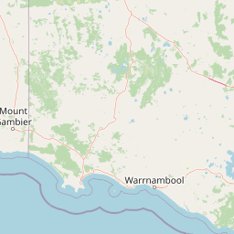
Map view of Mount Eccles National Park

Use this park location map to pinpoint Mount Eccles National Park in Australia, understand its exact geographic position, and read its mapped placement within the surrounding landscape more clearly.

Pigeon | © OpenStreetMap contributors
Park atlas

Map surrounding protected areas and their geographic spread from Mount Eccles National Park in Victoria, Australia.

Discover Nearby Protected Landscapes and Parks Surrounding Mount Eccles National Park

Users exploring Mount Eccles National Park can browse other nearby national parks and protected areas, extending across the volcanic plains of Victoria, Australia. Comparing these conservation landscapes provides valuable regional context for the area's unique volcanic features and broader protected geography.
National parkAustralia
Mapped location lies within the park boundary#1 closest

Budj Bim National Park: Ancient Volcanic Landscapes and World Heritage Protected Area

Explore the unique geography of Budj Bim National Park's crater lakes and lava tubes.

Budj Bim National Park offers an exceptional exploration of volcanic geography and ancient human ingenuity. This protected area features a dramatic landscape dominated by volcanic cones, lava tubes, and the picturesque Lake Surprise crater lake. Its significance is amplified by the presence of sophisticated Aboriginal aquaculture systems, developed thousands of years ago by the Gunditjmara people, which have contributed to its UNESCO World Heritage status. Discover the mapped terrain and protected land context of this geologically and culturally rich Australian national park.

Area
54.7 km²
Established
1960
IUCN
II
Relief
Mixed relief
Protected areaVictoria
About 1.5 km away#2 closest

East

Budj Bim heritage areas: Mapped Volcanic Landscapes and Ancient Aquaculture Systems

Regional protected geography in Victoria, Australia

Budj Bim heritage areas encompass a complex volcanic terrain in south-western Victoria, featuring extensive stone channel networks and managed wetland systems. This protected landscape documents thousands of years of Gunditjmara land engineering, from the dormant Budj Bim crater to the diverse marshlands of Tyrendarra. Access detailed map context and geographical data on this vital cultural and geological site.

Area
99.35 km²
IUCN
VI
Relief
Upland
Climate
Temperate
Protected areaVictoria
About 30 km away#3 closest

Southeast

Deen Maar Indigenous Protected Area: Mapped Geography and Coastal Landscape Profile

Gunditjmara country coastal terrain in south west Victoria.

Situated between the Eumeralla River and Bass Strait, Deen Maar Indigenous Protected Area features an unusual concentration of habitats within a small footprint. From calcareous limestone ridges to shallow lake systems and shifting dunes, the reserve serves as a crucial bird conservation area while maintaining deep ties to Gunditjmara cultural identity and management practices.

Area
4.53 km²
Established
1999
IUCN
VI
Relief
Lowland
National parkBarwon South West
About 31 km away#4 closest

West

Cobboboonee National Park: A Protected Landscape in Australia's Barwon South West Region

Explore its mapped geography and natural terrain.

Cobboboonee National Park represents an important protected area within the Barwon South West region of Australia. This destination offers users a deep dive into the park's specific geography, providing context on its mapped boundaries and the surrounding natural landscapes. It is designed for exploration of the park's protected-area identity and its place within the regional geography, offering structured data for landscape context.

Area
185.1 km²
Established
2008
IUCN
II
Climate
Temperate
National parkAustralia
About 42 km away#5 closest

West

Lower Glenelg National Park: Dramatic River Gorge and Limestone Cave Protected Landscape

Explore its mapped boundaries and unique geological features.

Lower Glenelg National Park in Victoria, Australia, is a national park celebrated for its visually stunning Glenelg River gorge. This protected area showcases millions of years of geological history etched into its limestone cliffs and features the accessible Princess Margaret Rose Cave. Understand the park's mapped landscape, its diverse terrain from riverine woodlands to coastal wetlands, and its significance within regional geographic exploration.

Area
273 km²
Established
1969
IUCN
II
Visitors
200K annual
National parkAustralia
About 42 km away#6 closest

Southwest

Mount Richmond National Park: Protected Area Atlas and Southwest Victoria Landscape

Explore mapped terrain and coastal woodland ecosystems.

Mount Richmond National Park is a vital protected area in Victoria's southwest, safeguarding coastal woodland and heath remnants on the region's volcanic plains. As a component of Victoria's national park system, it provides a geographically specific example of a protected landscape, contributing to the regional atlas of natural environments. Its landscape character is defined by eucalyptus woodlands and coastal influences, offering context for understanding conservation corridors and the mapped natural terrain of the southwestern Victorian coast. The park’s inclusion in long-distance walking routes also underscores its value for exploring protected natural areas.

Area
17.33 km²
Established
1960
IUCN
II
Relief
Mixed relief
National parkAustralia
About 51 km away#7 closest

Southwest

Discovery Bay Marine National Park: Victoria's Protected Coastal Marine Landscape

Mapped protected waters adjacent to Cape Bridgewater's unique geography.

Discover the geographic scope and protected landscape identity of Discovery Bay Marine National Park, an important marine national park located in Victoria, Australia, near Portland. This protected area safeguards a crucial stretch of the country's southern coastline, contributing to the ecological significance of the Southern Ocean marine region. Its position adjacent to the Discovery Bay Coastal Park highlights an integrated conservation approach, offering users a detailed view of its mapped marine boundaries and the distinctive geological context of the Cape Bridgewater area for atlas exploration.

Area
27.7 km²
Established
2002
IUCN
II
Climate
Temperate
National parkAustralia
About 62 km away#8 closest

Northeast

Grampians National Park National Park: Sandstone Ranges and Aboriginal Heritage Atlas

Explore its mapped protected landscape and regional geography.

Grampians National Park stands as a testament to Victoria's natural and cultural heritage, featuring striking sandstone mountain ranges and an exceptional concentration of Aboriginal rock art sites. This protected area offers a deep dive into the region's unique geology, from its ancient sedimentary rock formations to its dramatic cliff faces and peaks. Understanding the park's mapped boundaries and its place within the broader geography provides essential context for appreciating its protected landscape identity and its millennia-long human history.

Area
1,672.19 km²
Established
1984
IUCN
II
Relief
Mountain

Common questions about visiting, size, designation, and location context for Mount Eccles National Park

Mount Eccles National Park FAQs for park facts, access, geography, and protected area context

Find quick answers about Mount Eccles National Park, including protected-area facts, park geography, trail and visitor context, and how the park fits into its surrounding country and regional landscape.
MoriAtlas Explorer

Continue Your Protected Areas Search Across the Global Atlas

Deepen your exploration by continuing the structured search for national parks and protected areas worldwide. Utilize the comprehensive filtering capabilities to compare different conservation landscapes and refine your understanding of global park geography. Discover more about the distribution and characteristics of protected natural areas.

Global natural geography