
Mori Atlas logo
Protected areaMount Evans Wilderness

Mapping the alpine tundra, glacial cirques, and high-country ecosystems of this Colorado wilderness.

Mount Evans Wilderness: A Detailed Geographic Overview of a Colorado Front Range Protected Area

The Mount Evans Wilderness preserves seventy-four thousand acres of rugged terrain in central Colorado, representing a significant protected landscape within the Front Range. This atlas entry provides a detailed look at the area's physical geography, including transitions from dense subalpine forests to sweeping, exposed alpine tundra. By mapping the glacial landforms and the high-elevation ecosystems surrounding Mount Blue Sky, the content outlines the scale and character of this federally designated wilderness.

alpine wildernessFront Rangefourteenerglacier-carved terrainalpine tundrasubalpine forest
A colorful digital illustration showing a mountain range with pink and white snow patches, a blue lake, green grassy hills with yellow flowers, and pine trees under a sunny sky.

Mount Evans Wilderness

Protected area

Park overview

Structured park overview, official facts, and landscape profile for Mount Evans Wilderness

Mount Evans Wilderness park facts, protected area profile, and essential visitor context

Review the core facts for Mount Evans Wilderness, including designation, size, terrain, visitor scale, habitats, and operating context in one park-focused overview.

About Mount Evans Wilderness

Mount Evans Wilderness sits in the Front Range of the Colorado Rockies, where the steep eastern edge of the Rockies rises abruptly from the plains. Although it is close to Denver and other Front Range communities, the wilderness preserves a substantial expanse of remote, high-elevation terrain that few other American wildernesses near a major city can match. Its roughly seventy-four thousand acres include some of the most iconic scenery of the central Colorado Rockies, and its elevation gain from valley bottoms to the alpine crest is large enough to create a true ecological gradient across the protected area.

The wilderness is named after Mount Blue Sky, formerly known as Mount Evans, one of the celebrated fourteeners, peaks above fourteen thousand feet, of Colorado. The mountain dominates the wilderness skyline and, together with the deep cirque of Abyss Lake, defines much of the area's visual and ecological identity. The inclusion of Summit Lake near Mount Blue Sky's summit ridge gives the wilderness a focal point that is unusually distinctive among U.S. Wilderness Areas, since it pairs a high alpine lake with a major fourteener.

Mount Evans Wilderness is part of the National Wilderness Preservation System and is managed under the legal framework that defines U.S. Wilderness Areas. This means the area is intended to retain its primitive, untrammeled character, with restrictions on mechanized use and development that help preserve its ecological processes. The wilderness is administered through portions of two national forests, Arapaho National Forest and Pike National Forest, which jointly provide the institutional and management context for its stewardship.

Beyond its ecological importance, the wilderness represents a distinctive conservation achievement for the Denver metropolitan region. The mountain scenery above the city has long been a defining visual feature of Denver, and the designation of this area as Wilderness reflects an effort to formally safeguard the most striking parts of that landscape. The result is a protected area where visitors can move from the urbanized Front Range directly into genuine alpine wilderness within a relatively short distance, a rarity among American protected landscapes.

Quick facts and research context for Mount Evans Wilderness

Mount Evans Wilderness is a U.S. Wilderness Area in the Colorado Front Range, situated in Arapaho National Forest and Pike National Forest about thirty miles west of Denver. It spans Clear Creek County and Park County and covers roughly seventy-four thousand acres. The wilderness was formally established in 1980 and is administered by the U.S. Forest Service.

The area is anchored by Mount Blue Sky, formerly known as Mount Evans, one of the signature fourteener peaks of the Front Range. It also encompasses Summit Lake and the Abyss Lake Scenic Area, reflecting a layered protection history that predates the wilderness designation and includes earlier scenic and recreation-focused efforts linked to the Denver Mountain Parks system.

Protection and recognition

Terrestrial conservation scope, establishment year, and international recognition details

Mount Evans Wilderness Protection Status and 1980 Designation History

Mount Evans Wilderness maintains a documented terrestrial protection status established in 1980 across high altitude terrain. Structured conservation records outline the official designation history and management scope associated with the protected landscape.

Protection details

Protection scope
Terrestrial
Designated year
1980
Transboundary protection
No
Park context

Deeper park guide and search-rich context for Mount Evans Wilderness

Mount Evans Wilderness history, landscape, wildlife, and travel context

Explore Mount Evans Wilderness through its history, landscape character, ecosystems, wildlife, conservation priorities, cultural context, and seasonal travel timing in a structured park guide built for atlas discovery and search intent.

Why Mount Evans Wilderness stands out

Mount Evans Wilderness is best known for the towering presence of Mount Blue Sky and its position as one of the most accessible alpine wildernesses in the country, lying relatively close to a major metropolitan area. The area's high-elevation scenery, including Summit Lake near the summit of Mount Blue Sky, attracts visitors seeking genuine above-treeline experience without having to travel deep into the Rockies. Equally central to its identity is its glacial landscape of cirques, sheer walls, and alpine lakes. The Abyss Lake area, in particular, illustrates the area's origin in Pleistocene glaciation and gives the wilderness a defining combination of dramatic relief and classic Rocky Mountain alpine scenery.
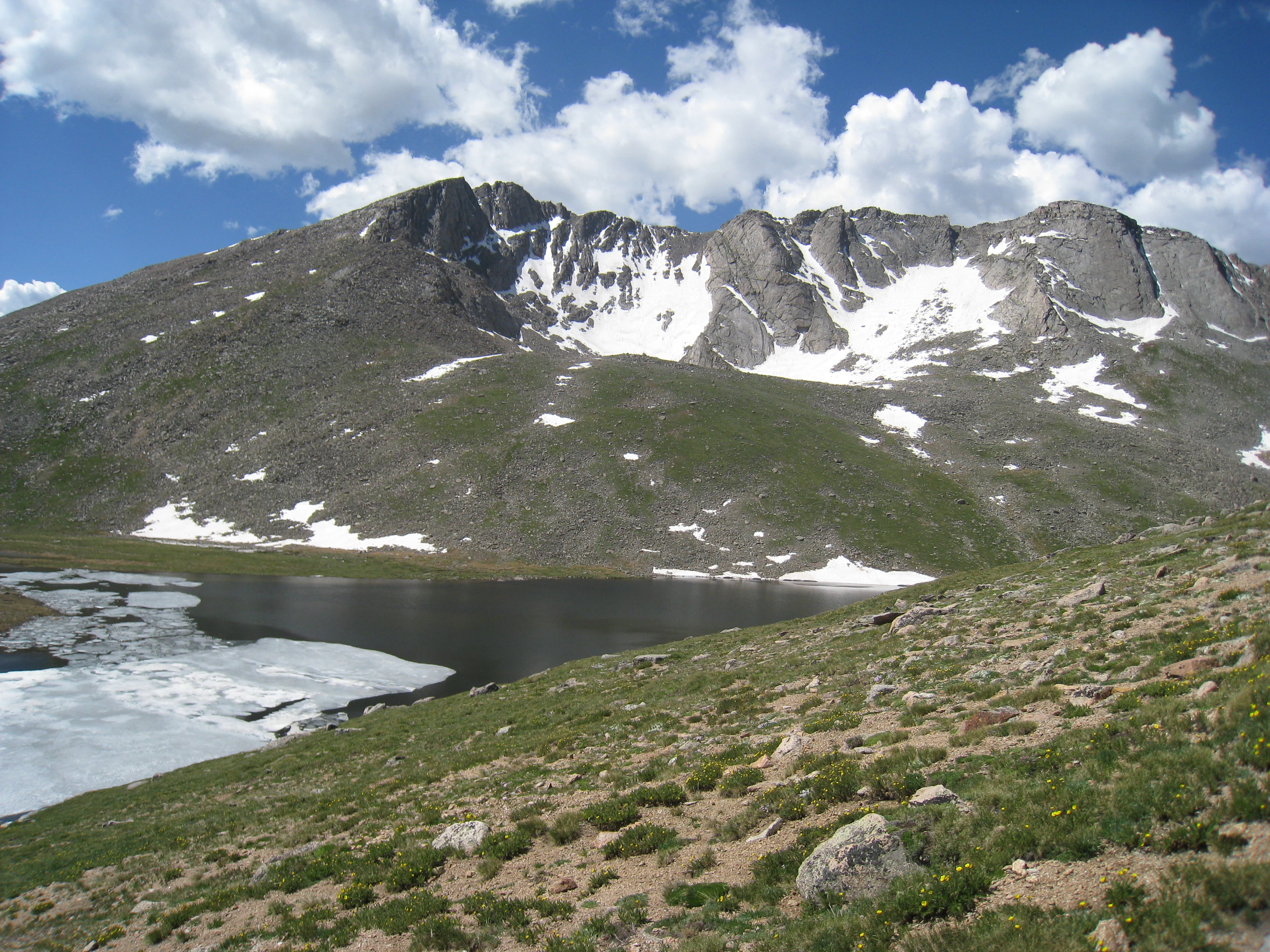
A wide shot of a rocky mountain with snow patches rising behind a lake with floating ice, surrounded by green alpine vegetation under a blue sky with white clouds.
Mount Evans rising above Summit Lake, with snow patches on the slopes and ice on the water under a blue sky.

Mount Evans Wilderness history and protected-area timeline

The early protection history of what is now Mount Evans Wilderness is tied closely to the Denver Mountain Parks system, a network of recreation areas designed in part by landscape architect Frederick Law Olmsted Jr. As part of that effort, key parcels including Echo Lake Park and Summit Lake Park were purchased, anchoring the early conservation framework around Mount Evans, now Mount Blue Sky. These early acquisitions were the foundation for later proposals that envisioned a National Park overlapping much of the present wilderness area.

The first large formal protection within the area was the establishment of the Abyss Lake Scenic Area in Pike National Forest, which safeguarded the Abyss Lake cirque and much of the Lake Fork of Scot Gomer Creek, a tributary of Geneva Creek that drains the southern slopes of Mount Blue Sky. This scenic area designation predates 1955 and represents the oldest layer of large-scale protection in the region.

The Mount Evans Wilderness itself was formally established in 1980 as part of the expansion of the U.S. Wilderness system during that era. Its designation brought together earlier protected parcels, including the Abyss Lake Scenic Area and the mountain parks, into a single comprehensively managed wilderness landscape, anchored by the looming presence of Mount Blue Sky.

Mount Evans Wilderness landscape and geographic character

The landscape of Mount Evans Wilderness is classic Colorado Front Range alpine terrain, defined by sharp relief, glacial scouring, and dramatic transitions between forested slopes and bare alpine expanses. The terrain rises from montane valleys through conifer forests into open tundra and exposed rock near the higher elevations. Throughout the wilderness, visitor perspectives shift quickly between dense forest stands, open meadows, talus slopes, and sheer cliff lines.

Glaciation has shaped many of the area's most striking features. Cirques carved into the mountainsides hold small alpine lakes and basins, and the Abyss Lake cirque is a particularly prominent example of this glacial legacy. Steep headwalls and cirque walls create rugged interior terrain that contrasts with the smoother subalpine ridges and plateaus characteristic of the area's middle elevations.

Above treeline, the wilderness opens into wide tundra expanses with sparse vegetation, rocky ground, and sweeping panoramic views across the Front Range. The ridgetops and summits, including those associated with Mount Blue Sky, expose the underlying rock and create the bare, open character that defines the area's alpine identity. Below these high zones, forests of spruce, fir, and pine clothe the slopes and frame the wilderness from lower elevations.

Mount Evans Wilderness ecosystems, habitats, and plant life

Mount Evans Wilderness contains a clear ecological gradient that reflects its substantial elevation range. Lower elevations support coniferous forests typical of the southern Rockies, dominated by species such as spruce and fir, with stands of pine in drier settings. These forests provide dense cover and form the base of the wilderness's ecological structure, supporting both resident wildlife and seasonal visitors.

As elevation increases, the forests thin and the vegetation transitions into subalpine parkland and eventually into alpine tundra. The treeline ecotone, where stunted trees give way to open grass and sedge communities, is ecologically important and visually distinctive. Above treeline, alpine plants adapted to short growing seasons and harsh conditions take over, with low-growing cushion plants, hardy grasses, and lichen-covered ground.

The wilderness also encompasses a number of alpine and subalpine wetlands and lakes. Summit Lake, near the upper slopes of Mount Blue Sky, is particularly notable as a high-elevation waterbody, while the Abyss Lake basin supports its own set of wet habitats and associated ecological communities. These aquatic and wetland features contribute to habitat diversity and increase the overall ecological richness of the wilderness.

Mount Evans Wilderness wildlife and species highlights

The wildlife of Mount Evans Wilderness reflects the vertical range of the area, with different species communities associated with forested slopes, subalpine meadows, and high tundra. The forests host typical Rocky Mountain mammals such as elk, mule deer, black bears, and various small mammals, while the open alpine zones support species adapted to harsher conditions and more open terrain.

Bighorn sheep are among the most iconic large mammals in similar Front Range terrain and are part of the broader mountain ungulate community that includes elk and mule deer. Smaller carnivores, such as marmots and pikas, inhabit the talus slopes and rock fields of the higher elevations, where they are well adapted to the alpine environment.

Birds are also an important component of the wildlife profile, with raptor species such as hawks and eagles using the strong thermal currents and dramatic cliffs of the area, while smaller alpine and forest bird species occupy the various habitat zones from treeline to dense conifer forest. The combination of cliffs, meadows, forest, and water bodies gives the wilderness habitat diversity that supports a rich and seasonally variable avifauna.

Mount Evans Wilderness conservation status and protection priorities

As a federally designated U.S. Wilderness Area, Mount Evans Wilderness sits within the National Wilderness Preservation System, which provides the highest level of landscape protection available for U.S. Forest Service lands. Wilderness designation emphasizes the preservation of natural conditions, ecological processes, and the area's untrammeled character, restricting activities that would otherwise alter the wilderness.

The wilderness also reflects a layered conservation history, including the earlier protection of the Abyss Lake Scenic Area and the long-standing protection of Echo Lake Park and Summit Lake Park under the Denver Mountain Parks system. Together these designations have created an unusually well-protected landscape near a major metropolitan area, ensuring that the scenic and ecological values of the Mount Blue Sky region are maintained despite their proximity to Denver.

From a broader conservation perspective, the area matters because it safeguards a representative slice of Colorado's Front Range alpine and subalpine ecosystems in a contiguous block of protected land. The wilderness supports ecological connectivity, protects sensitive alpine plant communities, and preserves habitat for high-elevation wildlife. Its conservation significance is amplified by the unusual combination of ecological quality and accessibility from a major Western U.S. city.

Mount Evans Wilderness cultural meaning and human context

The Mount Evans Wilderness area has deep ties to the early development of Denver's mountain park system, one of the most ambitious urban mountain park networks in the United States. Landscape architect Frederick Law Olmsted Jr. played a role in designing this system, and the early purchases of parcels including Echo Lake Park and Summit Lake Park were foundational for the area's protection. These mountain parks reflect an early twentieth-century vision of making surrounding mountain scenery publicly accessible from the growing city of Denver.

The area's cultural identity is closely tied to the broader Colorado mountain heritage of the Front Range, where peaks such as Mount Blue Sky are part of the regional imagination and visible landmarks from the metropolitan area. Although the wilderness itself is primarily valued for its natural character, it sits within a landscape that has long held meaning for residents of the Front Range and has shaped the regional identity of the Denver area.

Top sights and standout views in Mount Evans Wilderness

Mount Evans Wilderness stands out for combining a major Colorado fourteener, Mount Blue Sky, with the broader ecosystem of one of the most accessible alpine wildernesses in the country. The presence of Summit Lake on the flanks of Mount Blue Sky adds an unusually distinctive high-elevation focal point to the wilderness.

Equally important are the wilderness's glacial landforms, particularly the Abyss Lake cirque, and the continuous transition from montane forest to alpine tundra. The wilderness also stands out for its proximity to Denver, making it a notable example of wilderness protection that preserves cliff-lined alpine scenery in a region dominated by urban and recreational pressure.

Best time to visit Mount Evans Wilderness

Summer and early fall are the most natural windows for visiting Mount Evans Wilderness, when high-country roads and trails are most accessible and the alpine zones are free of deep snow. Midsummer typically brings wildflower displays in the subalpine meadows and the most comfortable conditions for travel above treeline, while early fall offers cooler temperatures, reduced crowds, and the first signs of seasonal color in the higher vegetation.

Winter brings heavy snow at the higher elevations and significantly limits access, although the forested lower parts of the wilderness remain attractive for snowshoeing and other snow-season activities. Spring is highly variable, with lingering snowpack at high elevations and unstable conditions in alpine terrain, making summer through early fall the most reliable window for experiencing the full vertical range of the wilderness.

Monthly climate preview

Long-term monthly temperature and precipitation records sampled from representative terrain coordinates

Mount Evans Wilderness Climate Normals and Measured Annual Temperature Patterns

Representative coordinate records show measured monthly temperature variation alongside consistent precipitation patterns across the protected landscape. Exploring the full twelve-month profile reveals detailed baseline climate data for this conservation area.
Annual mean2 °C
-8 °C15 °C
Jan-8°
Feb-8°
Mar-4°
Apr
May
Jun12°
Jul15°
Aug14°
Sep10°
Oct
Nov-4°
Dec-8°
Warmest month
July

15.3 °C

Coolest month
January

-8.4 °C

Wettest month
April

2.1 mm/day

Driest month
December

1 mm/day

Park location guide

Geography guide, regional context, and park location map for Mount Evans Wilderness

Mount Evans Wilderness park geography, regions, and map view in United States of America

Understand where Mount Evans Wilderness sits in United States of America through a broader geographic reading of the surrounding landscape, nearby location context, and its mapped position within the national park landscape.

How Mount Evans Wilderness fits into United States of America

The United States of America is a federal presidential republic and one of the world's largest countries by area and population. It consists of 50 states across a vast territory spanning multiple time zones, with its capital in Washington, D.C. and largest city in New York City. The nation has a diverse economy, influential political system, and significant cultural and military presence globally.

Wider geography shaping Mount Evans Wilderness in United States of America

The United States occupies a vast territory in North America, bordered by Canada to the north and Mexico to the south. The 48 contiguous states stretch from the Atlantic to the Pacific Ocean, while Alaska occupies the northwestern region and Hawaii is an archipelago in the Pacific. The country encompasses diverse terrain including the Rocky Mountains, Appalachian Mountains, Great Plains, and extensive river systems.

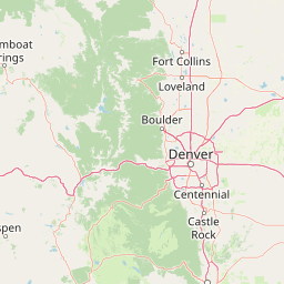
Map view of Mount Evans Wilderness

Use this park location map to pinpoint Mount Evans Wilderness in United States of America, understand its exact geographic position, and read its mapped placement within the surrounding landscape more clearly.

Pigeon | © OpenStreetMap contributors

Location context for Mount Evans Wilderness

Colorado
Recorded earthquake history

Browse the Mount Evans Wilderness Historical Earthquake and Seismic Record Collection

Examine the chronological catalogue of recorded seismic activity documented near the Mount Evans Wilderness. This structured record provides researchers and visitors with reliable data on local epicentre proximity and event magnitudes within the Front Range alpine landscape.

Mount Evans Wilderness Earthquake History

Catalogued events

1 event

Strongest magnitude

Magnitude 3

Most recent event

Sep 12, 1990

This history includes earthquakes recorded inside the park or within 50 km of its borders

Visual reference for glacial cirques, high-altitude terrain, and protected alpine ecosystems

Mount Evans Wilderness Photos and Alpine Scenery: Exploring Colorado Front Range Landscapes

Visual records capture the rugged topography, sweeping tundra plateaus, and glacial cirques defining Mount Evans Wilderness. Photographic exploration reveals the protected alpine environment and continuous forest gradients shaping the Colorado Front Range.

A wide shot of a rocky mountain with snow patches rising behind a lake with floating ice, surrounded by green alpine vegetation under a blue sky with white clouds.

Park atlas

Compare surrounding high-elevation terrain and regional mountain geography

Parks Near Mount Evans Wilderness and Connected Protected Landscapes

Browse nearby national parks and protected areas sharing the rugged alpine characteristics of Mount Evans Wilderness. Geographic comparison across the surrounding region reveals broader patterns in high-elevation conservation and mountain terrain.
A soft watercolor illustration depicting a simplified, layered landscape of rolling hills and distant mountains in shades of light green, pale yellow, and soft pink.
Protected areaColorado
Park boundaries overlap#1 closest

Southeast

Pike National Forest: Protected Mountain Landscapes and Regional Geography in Central Colorado

Granite peaks, montane forests, and diverse alpine terrain

Spanning from the rolling foothills of the Front Range to the high alpine summits of the Rocky Mountains, Pike National Forest is a significant protected area defined by its unique Pikes Peak granite bedrock and deep river-carved canyons. This analysis provides a structured look at its expansive wilderness boundaries, drainage basins, and the vertical transitions that characterize this vital central Colorado highland.

Area
4,478.27 km²
Established
1892
Relief
Mountain
Climate
Alpine
Protected landscapeColorado
Mapped location lies within the park boundary#2 closest

West

White River National Forest: Mapping the Protected Landscapes and High Country of Central Colorado

Regional geography, wilderness boundaries, and mountain terrain data

Spanning from the high alpine tundra of the Sawatch Range to the volcanic plateaus of the Flat Tops, White River National Forest represents a significant protected area in the American West. This detail presents the geographic footprint, forest landscape, and complex mountain terrain that define this vital Colorado territory.

Area
9,251 km²
Established
1902
Relief
Mountain
Climate
Alpine
A horizontal watercolor painting showing a range of purple and reddish-toned mountains in the distance, behind rolling green fields and a pale pinkish waterway in the foreground.
Protected landscapeColorado
20 km away#3 closest

North

Roosevelt National Forest: Mapping Wilderness and Protected Landscapes in Northern Colorado

Regional geography, river corridors, and alpine mountain terrain

Roosevelt National Forest encompasses a significant protected landscape across Larimer, Boulder, Gilpin, and Jefferson counties. The forest features a complex terrain of deep canyons, forested plateaus, and protected wilderness areas that form a scenic buffer along the eastern side of the Continental Divide and Rocky Mountain National Park.

Area
3,293.33 km²
Established
1902
Relief
Mountain
Climate
Subpolar
A watercolor painting showing a panoramic view of mountain peaks in the background behind a forest landscape, set against a white background.
Wildlife reserveColorado
About 21 km away#4 closest

North

James Peak Wilderness: Geographic Profile and Protected Landscape Mapping

High elevation terrain in the Colorado Rockies

James Peak Wilderness provides a critical protected landscape featuring dramatic alpine summits, U-shaped glacial valleys, and subalpine meadows. Its geographic structure forms an essential ecological link along the Colorado Front Range, characterized by high-elevation peaks, dense coniferous forests, and diverse tundra ecosystems situated immediately east of the Continental Divide.

Area
68.86 km²
Established
2002
IUCN
Ib
Watercolor painting of reddish granite rock outcrops surrounded by green forest and distant hazy mountain ridges.
Wildlife reserveColorado
About 24 km away#5 closest

South

Lost Creek Wilderness: A Mapped Atlas of Granite Formations and Protected Colorado Terrain

Exploratory mapping of central Colorado mountain foothills

Lost Creek Wilderness represents a significant protected corridor within the Pike National Forest of Colorado. The region is characterized by an unusual density of granite spires, arches, and domes, providing a distinct contrast to typical alpine landscapes. By examining the mapped boundaries and natural features of this wildlife reserve, users can better understand the unique hydrographic and geological systems that define this notable section of the Rocky Mountains.

Area
484.8 km²
Established
1980
IUCN
Ib
Relief
Mountain
A watercolor painting of a mountain landscape featuring a small lake, grassy slopes, and conifer trees with a prominent rocky peak in the distance.
Wildlife reserveColorado
29 km away#6 closest

North

Indian Peaks Wilderness: Alpine Geography and Front Range Protected Landscapes

Mapping high country summits and glacial basins in Colorado

Indian Peaks Wilderness stands as a signature wildlife reserve along the Colorado Continental Divide. This atlas entry focuses on its complex system of thirteen-thousand-foot peaks, relict glaciers, and interconnected alpine lakes that define the Front Range. Gain insight into the protected boundaries and glacial geomorphology that characterize this high-country landscape near the Denver metropolitan region.

Area
310.44 km²
Established
1978
IUCN
Ib
Relief
Mountain
Wildlife reserveColorado
32 km away#7 closest

West

Eagles Nest Wilderness: Alpine Geography and Protected Landscape of the Colorado Gore Range

High-mountain protected area in the White River National Forest

Spanning the southern Gore Range, Eagles Nest Wilderness represents a core protected landscape in Colorado characterized by high-elevation peaks, glacial cirque lakes, and extensive backcountry trail networks. Its geography bridges the gap between deep coniferous forests and exposed alpine tundra, maintaining significant ecological and historical value within the mountainous terrain of Eagle and Summit Counties.

Area
546.79 km²
Established
1976
IUCN
Ib
Relief
Mountain
Protected landscapeGrand County
37 km away#8 closest

North

Arapaho National Recreation Area: Geographic Profile and Protected Landscape Context

High-country mountain reservoirs and forested mountain terrain

The Arapaho National Recreation Area defines a unique intersection of montane forest and water-based geography in Grand County, Colorado. As the home to the Great Lakes of Colorado, this protected landscape provides a critical connection point between the Colorado River headwaters and the Continental Divide. Examine the park's terrain, reservoir distribution, and its role as a forested gateway to the neighboring mountain regions.

Area
124.2 km²
Established
1978
Relief
Mountain
Climate
Alpine

Common questions about visiting, size, designation, and location context for Mount Evans Wilderness

Mount Evans Wilderness FAQs for park facts, access, geography, and protected area context

Find quick answers about Mount Evans Wilderness, including protected-area facts, park geography, trail and visitor context, and how the park fits into its surrounding country and regional landscape.
MoriAtlas Explorer

Continue Your Protected Areas Search Across the Global Atlas

Deepen your exploration by continuing the structured search for national parks and protected areas worldwide. Utilize the comprehensive filtering capabilities to compare different conservation landscapes and refine your understanding of global park geography. Discover more about the distribution and characteristics of protected natural areas.

Global natural geography