

Mori Atlas logo
National parkMurray Valley National Park

Discover the geographic context and protected landscape of Murray Valley National Park.

Murray Valley National Park: A Key National Park in New South Wales for Atlas Exploration

Murray Valley National Park stands as a significant protected area within the Australian state of New South Wales. This national park offers a unique opportunity for atlas-driven discovery, allowing users to explore its mapped boundaries and understand its place within the broader regional geography. Uncover the natural landscapes and protected terrain that define this important conservation area.

Red river gum forestWetland ecosystemsRiverina regionNew South Wales national parksEndangered species habitatMurray-Darling Basin

Murray Valley National Park

National park

Park overview

Structured park overview, official facts, and landscape profile for Murray Valley National Park

Murray Valley National Park park facts, protected area profile, and essential visitor context

Review the core facts for Murray Valley National Park, including designation, size, terrain, visitor scale, habitats, and operating context in one park-focused overview.

About Murray Valley National Park

Murray Valley National Park protects a remarkable riverine ecosystem in the heart of the Murray-Darling Basin. The park's landscape is dominated by the iconic red river gum, Eucalyptus camaldulensis, which thrives along the Murray River floodplain and creates one of Australia's most extensive forested wetland environments. The park encompasses a network of interconnected waterways, permanent lagoons, and seasonal wetlands that sustain the forest ecosystem through the flood and drought cycles that characterize this part of inland Australia. The red river gum forests of Murray Valley represent a ecological community of national importance, providing habitat for species found nowhere else on Earth. The park's establishment in 2010 marked a significant milestone in the conservation of Australia's riverine environments, formalizing protection for an ecosystem that had previously existed across multiple state forest designations. The conservation of this area recognizes that healthy river gum forests along the Murray are essential for maintaining water quality, supporting aquatic ecosystems, and providing refuge for wildlife during periods of drought.

Quick facts and research context for Murray Valley National Park

The park occupies 416.01 square kilometres in the Riverina region of New South Wales, situated near the town of Mathoura. It was created through the consolidation of several former state forests and is administered by the NSW National Parks and Wildlife Service. The park forms part of a trans-boundary conservation partnership with Barmah National Park across the Murray River in Victoria, together forming the largest red river gum forest in Australia. The ecosystem supports 60 endangered native animal species and 40 endangered plant species, making it one of the most significant conservation areas in the Murray-Darling Basin.

Protection and recognition

Documenting terrestrial management scope and official designations within regional park systems.

Murray Valley National Park Protection Status and Conservation Designation

Murray Valley National Park maintains a documented terrestrial protection status aligned with regional conservation standards and structured environmental management frameworks. Reviewing official designation details and geographic boundaries helps researchers verify the conservation status of critical inland habitats.

Protection details

Protection scope
Terrestrial
Transboundary protection
No
Park context

Deeper park guide and search-rich context for Murray Valley National Park

Murray Valley National Park history, landscape, wildlife, and travel context

Explore Murray Valley National Park through its history, landscape character, ecosystems, wildlife, conservation priorities, cultural context, and seasonal travel timing in a structured park guide built for atlas discovery and search intent.

Why Murray Valley National Park stands out

Murray Valley National Park is best known for its spectacular red river gum forests, which represent the largest continuous stand of this iconic Australian tree species in the country. The park's extensive wetlands, including the notable Bullanginya Lagoon, provide critical habitat for waterbirds and migratory species. The floodplain ecosystem supports an extraordinary concentration of endangered flora and fauna, with particular significance for species adapted to riverine forest environments. The park also stands out for its role as a cross-border conservation area linking protected lands in New South Wales and Victoria.

Murray Valley National Park history and protected-area timeline

Murray Valley National Park was formally established in July 2010 through the proclamation of what had previously been a series of state forest reserves. The creation of the national park represented the culmination of years of advocacy for stronger environmental protection of the Murray River floodplain forests. Prior to national park status, the area functioned as state forests managed primarily for timber production, though the ecological value of the river gum communities was increasingly recognized. The transition to national park status brought the area under the management framework of the NSW National Parks and Wildlife Service, providing stronger conservation protections and enabling ecological restoration programs. The park's establishment also formalized cross-border cooperation with Victoria's Barmah National Park, recognizing that the Murray River forms a natural boundary that does not respect political divisions in conservation planning.

Murray Valley National Park landscape and geographic character

The landscape of Murray Valley National Park is defined by the Murray River floodplain, a flat to gently undulating terrain characterized by natural levees, abandoned river channels, and extensive wetland basins. The red river gum dominates the forest canopy, with trees often growing to impressive heights along the water's edge and spreading across the adjacent floodplains. The park contains numerous lagoons and billabongs that form critical wet habitats within the broader forest matrix. These water bodies range from permanent deep lagoons to seasonal wetlands that fill during river flooding events. The vegetation pattern creates a mosaic of dense forest along watercourses, more open woodland on the higher ground, and open wetlands in the lowest-lying areas. The scenery changes dramatically with the seasons, from the lush greens of flood periods to the more subdued tones of the dry season.

Murray Valley National Park ecosystems, habitats, and plant life

The red river gum forest of Murray Valley represents a unique ecological community adapted to the seasonal flooding and prolonged dry periods characteristic of the Murray River system. These trees have evolved to survive both inundation and drought, with roots that can withstand prolonged waterlogging and the ability to access groundwater during dry spells. The forest structure provides a complex habitat layer, from the canopy where birds nest to the leaf litter and fallen timber that shelter invertebrates and small mammals. The wetlands within the park support distinctive aquatic plant communities and provide feeding and breeding grounds for fish, frogs, and water-dependent reptiles. The diversity of habitats within a relatively compact area creates conditions for exceptional species richness, particularly in the reptile and bird communities.

Murray Valley National Park wildlife and species highlights

Murray Valley National Park provides critical habitat for 60 endangered native animal species, making it one of the most significant faunal conservation areas in the Murray-Darling Basin. The river gum forests and wetlands support populations of hollow-dependent species including various possums, gliders, and bats that require old trees with suitable nesting cavities. The waterbird community is particularly diverse, with populations of pelicans, herons, ibis, and ducks using the wetlands throughout the year. The lagoons and slow-moving channels provide important habitat for fish species including Murray cod and golden perch. The forest floor supports populations of reptiles and invertebrates that are adapted to the complex leaf-litter environment. Emus are commonly observed moving through the more open areas of the park, while white-faced herons and Australian white ibis forage along the water's edge.

Murray Valley National Park conservation status and protection priorities

The conservation significance of Murray Valley National Park extends far beyond its boundaries as part of the largest remaining red river gum forest ecosystem in Australia. The park protects a community of plants and animals that has declined dramatically elsewhere in the Murray-Darling Basin due to water extraction, river regulation, and land clearing. The 40 endangered plant species found within the park include specialists of the riverine forest floor that require the specific conditions created by the flood regime. The endangered animal species represent both forest-dwelling organisms and wetland-dependent fauna, highlighting the dual importance of the forest and aquatic habitats. Conservation management focuses on maintaining natural flood patterns where possible, managing fire to protect old-growth trees, and controlling invasive species that threaten the integrity of the river gum ecosystem.

Murray Valley National Park cultural meaning and human context

Murray Valley National Park is situated in traditional Aboriginal country and represents a landscape of deep Indigenous cultural significance. The park area has been occupied by Aboriginal peoples for thousands of years, with the river floodplain providing reliable food and water resources throughout the changing seasons. The lagoons and river channels were important gathering places, with the floodplain supporting diverse plant and animal foods. The landscape contains places of traditional significance, and the park management recognizes the importance of maintaining connection between Indigenous communities and their traditional lands. The relationship between Aboriginal people and the river gum forests represents a long history of sustainable land use that shaped the landscape before European settlement.

Top sights and standout views in Murray Valley National Park

The park's defining feature is the magnificent red river gum forest, Australia's largest remaining stand of this iconic species, creating a distinctive landscape of twisted trunks and spreading canopies along the water's edge. The wetlands, particularly Bullanginya Lagoon, provide outstanding birdwatching opportunities with populations of pelicans, herons, and ibis regularly observed. The cross-border connection with Barmah National Park in Victoria creates an international conservation partnership protecting a shared ecosystem. The park offers a relatively accessible wilderness experience in southern New South Wales, with opportunities for bushwalking, birdwatching, and photography in a landscape that changes dramatically with the seasons. The presence of 60 endangered animal species and 40 endangered plant species makes this a significant site for ecological appreciation and conservation awareness.

Best time to visit Murray Valley National Park

The best time to visit Murray Valley National Park depends on what visitors hope to experience. The wetland birdlife is most active and visible during the spring and summer months when waterbirds breed and juveniles are observable. Autumn offers pleasant temperatures and the opportunity to see the forest in quieter conditions as the heat of summer eases. Winter can bring flooding events that transform the landscape but may also make some tracks and areas less accessible. The park has a character throughout the year, and each season offers a different perspective on this complex ecosystem.
Monthly climate preview

Long-term representative measurements of monthly temperature and precipitation for Murray Valley National Park

Murray Valley National Park Climate Normals and Annual Temperature Rhythm

Representative coordinates record measured monthly temperature and precipitation baselines across the annual cycle for Murray Valley National Park. Reviewing the complete twelve-month profile provides detailed long-term averages for thermal and moisture patterns at this New South Wales protected location.
Annual mean16 °C
8 °C25 °C
Jan25°
Feb24°
Mar21°
Apr16°
May12°
Jun
Jul
Aug
Sep12°
Oct16°
Nov19°
Dec22°
Warmest month
January

24.8 °C

Coolest month
July

8 °C

Wettest month
November

1.4 mm/day

Driest month
March

0.9 mm/day

Park location guide

Geography guide, regional context, and park location map for Murray Valley National Park

Murray Valley National Park park geography, regions, and map view in Australia

Understand where Murray Valley National Park sits in Australia through a broader geographic reading of the surrounding landscape, nearby location context, and its mapped position within the national park landscape.

How Murray Valley National Park fits into Australia

Australia is a constitutional monarchy and federal parliamentary democracy comprising six states and ten territories. With a population of nearly 28 million, it is one of the world's most urbanised countries, with most people concentrated on the eastern seaboard. The country has a high Human Development Index and is known for its cultural diversity, ancient Aboriginal heritage, and unique wildlife.

Wider geography shaping Murray Valley National Park in Australia

Australia occupies the entire Australian continent, the island of Tasmania, and numerous smaller islands. It is the world's flattest and driest inhabited continent, featuring vast deserts in the interior (the Outback), tropical rainforests along the eastern coast, and a coastline bordering the Indian and Pacific Oceans.

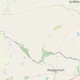
Map view of Murray Valley National Park

Use this park location map to pinpoint Murray Valley National Park in Australia, understand its exact geographic position, and read its mapped placement within the surrounding landscape more clearly.

Pigeon | © OpenStreetMap contributors

Location context for Murray Valley National Park

New South WalesRiverina
Natural feature types

Explore the Named Natural Features and Geographic Landscape of Murray Valley National Park

Navigate the diverse array of protected natural landmarks, water bodies, and forested areas associated with Murray Valley National Park. This MoriAtlas collection provides a focused geographic view of the features that shape this significant Australian riverine ecosystem and forest landscape.
Recorded earthquake history

Explore Historical Earthquake Records for Murray Valley National Park

Review documented seismic events near Murray Valley National Park through this structured historical catalogue. MoriAtlas provides transparent access to past earthquake data, allowing for deeper engagement with the geographic and environmental history of this New South Wales protected forest area.

Murray Valley National Park Earthquake Records

Catalogued events

18 events

Strongest magnitude

Magnitude 4.4

Most recent event

Jul 23, 2018

This history includes earthquakes recorded inside the park or within 50 km of its borders

Park atlas

Compare surrounding national parks and protected landscapes across the Murray River floodplain geography.

Explore More Protected Areas Near Murray Valley National Park and the Riverina Region

Browse other protected areas and national parks adjacent to Murray Valley National Park, exploring the diverse Riverina region and the extensive Murray River floodplain ecosystem. This geographic overview aids in comparing the spread and conservation context of red river gum forests and wetland habitats across Australia's protected landscapes.
Watercolor illustration of a river landscape with green hills, trees, and pink reeds
National parkAustralia
0 km away#1 closest

South

Barmah National Park National Park: World's Largest River Red Gum Forest Landscape

Explore Mapped Boundaries and Wetland Geography

Barmah National Park in Victoria, Australia, is renowned for protecting the largest river red gum floodplain forest on Earth, a globally significant Ramsar-listed wetland. This protected area's landscape is defined by majestic eucalypts bordering freshwater marshes along the Murray River. Dive into its distinct geography, mapped terrain, and the protected status of this remarkable ecosystem, offering unparalleled opportunities for understanding regional natural landscapes and conservation.

Area
285.21 km²
Established
2010
IUCN
II
Relief
Lowland
National parkAustralia
4.7 km away#2 closest

South

Lower Goulburn National Park: Australia's River Red Gum Woodland Protected Landscape

Explore mapped boundaries and riparian geography.

Lower Goulburn National Park in Victoria, Australia, safeguards a critical segment of the Goulburn River, celebrated for its magnificent river red gum woodlands. This protected area offers a linear exploration of a rare riparian ecosystem, providing essential habitat and scenic beauty. Understand its geographic layout, mapped extent, and the distinctive landscape formed by these iconic Australian trees, offering a vital natural contrast to the surrounding agricultural areas.

Area
93.1 km²
Established
2010
IUCN
II
Relief
Lowland
National parkAustralia
13 km away#3 closest

Southeast

Warby-Ovens National Park: Protected Landscape and Geographic Atlas Entry

Discover its Box-Ironbark forests and mapped regional terrain.

Warby-Ovens National Park is a protected national park situated in northeastern Victoria, Australia, covering 14,655 hectares of distinctive landscape. It is internationally recognized as an Important Bird Area, primarily for its significant Box-Ironbark forest ecosystem that supports numerous threatened woodland bird species. The park's geography features low granite hills and rolling terrain, with the Ovens River flowing through its northern section. This detail page provides structured information on its protected boundaries, natural landscape characteristics, and its place within regional geography.

Area
146.55 km²
Established
2010
IUCN
II
Relief
Upland
National parkAustralia
19 km away#4 closest

East

Chiltern-Mt Pilot National Park: Box-Ironbark Forest & Mapped Landscape

Explore its protected areas and regional geographic context.

Chiltern-Mt Pilot National Park preserves a significant portion of Victoria's box-ironbark forest, an ecosystem vital for threatened species and rich biodiversity. This park showcases varied terrain, from sedimentary hills to granite landscapes, offering a compelling subject for geographic study. Understand its mapped extent and its role within the broader regional geography, providing deep insights for atlas-based exploration.

Area
215.6 km²
Established
2002
IUCN
II
Relief
Mixed relief
National parkAustralia
24 km away#5 closest

West

Gunbower National Park: A National Park Protecting River Red Gum Forests and Ramsar Wetlands

Explore its mapped riverine landscape and regional protected area context.

Gunbower National Park offers a unique glimpse into Victoria's vital floodplain ecosystems, prominently featuring extensive River Red Gum forests and Ramsar-designated wetlands. This protected national park, situated along the Murray River, serves as a crucial sanctuary for migratory bird species within the Murray-Darling Basin. Its landscape is defined by waterways like Gunbower Creek and a mosaic of aquatic habitats, representing an important conservation area for its ecological communities and geographic significance.

Area
93.3 km²
Established
2010
IUCN
II
Relief
Lowland
National parkAustralia
34 km away#6 closest

Southwest

Terrick Terrick National Park: National Park Geography and Protected Land Exploration

Semi-arid woodland and grassland ecosystems in northern Victoria.

Terrick Terrick National Park represents a crucial protected area showcasing the characteristic Box-Ironbark forest and native grassland ecosystems of northern Victoria. This park is defined by its gently undulating terrain and semi-arid woodland character, offering a distinct natural landscape for geographic study and atlas exploration. Its mapped extent clearly delineates an environment vital for conservation, providing a valuable point of reference for understanding regional protected land distribution and ecological significance within Australia.

Area
38.8 km²
Established
1988
IUCN
II
Relief
Lowland
National parkNew South Wales
48 km away#7 closest

Northwest

Yanga National Park National Park: Mapped Boundaries and Regional Geographic Context in New South Wales

Protected landscape atlas entry for New South Wales.

Examine Yanga National Park, a dedicated national park situated in New South Wales, Australia. This entry provides essential details for atlas-based discovery, focusing on its mapped boundaries, protected area status, and integration into the regional geography. Understanding Yanga National Park contributes to a broader comprehension of protected lands and their distribution, offering a clear geographic perspective on conservation efforts within New South Wales for users seeking structured landscape data.

Area
667.34 km²
Established
2007
IUCN
II
Relief
Lowland
Nature reserveNew South Wales
About 56 km away#8 closest

East

Wiesners Swamp Nature Reserve: Mapping the Floodplain Landscapes of New South Wales

A preserved ephemeral wetland and woodland habitat

Wiesners Swamp Nature Reserve represents a critical protected wetland basin in the South Western Slopes of New South Wales. The reserve provides a mapped view of seasonal floodplain dynamics, including river red gum woodland and woodland patches on higher ground that support local waterbirds and native mammals.

Area
1.03 km²
Established
1996
IUCN
Ia
Relief
Lowland

Common questions about visiting, size, designation, and location context for Murray Valley National Park

Murray Valley National Park FAQs for park facts, access, geography, and protected area context

Find quick answers about Murray Valley National Park, including protected-area facts, park geography, trail and visitor context, and how the park fits into its surrounding country and regional landscape.
MoriAtlas Explorer

Continue Your Protected Areas Search Across the Global Atlas

Deepen your exploration by continuing the structured search for national parks and protected areas worldwide. Utilize the comprehensive filtering capabilities to compare different conservation landscapes and refine your understanding of global park geography. Discover more about the distribution and characteristics of protected natural areas.

Global natural geography