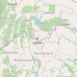
Why Na Yung, Nam Som National Park stands out
Na Yung, Nam Som National Park is best known for its intact dry dipterocarp forest ecosystems, which represent a characteristic vegetation type of mainland Southeast Asia that has faced significant pressure across the region. The park protects critical watershed functions for multiple river systems in the provinces of Udon Thani, Loei, and Nong Khai. The landscape features prominent sandstone cliffs at the Pha Daeng Viewpoint, which offers panoramic views over the forested slopes and connects to a network of nature trails leading to waterfalls including Yung Thong and Tat Noi. The combination of relatively preserved forest condition, mountain peak habitats, and waterfall attractions makes this park notable within Thailand's northeastern protected area network.
Na Yung, Nam Som National Park history and protected-area timeline
The area comprising Na Yung–Nam Som National Park was originally established as a forest park in December 1975, reflecting Thailand's broader policy during that period of designating forest reserves and protected areas to preserve remaining natural vegetation and watershed functions. The transition from forest park to national park status has proceeded gradually, with the area remaining in preparation as of 2022 while functioning under national park governance through the Department of National Parks, Wildlife and Plant Conservation. The establishment of the protected area corresponded with growing recognition in Thailand during the 1970s of the need to conserve remaining forest resources in the northeast, a region that had experienced significant deforestation due to agricultural expansion, logging, and shifting cultivation. The park's boundary encompasses portions of Nam Som District and reflects the intersection of three provincial jurisdictions, a common feature in Thai protected area planning that often places significant natural areas at administrative boundaries.
Na Yung, Nam Som National Park landscape and geographic character
The landscape of Na Yung–Nam Som National Park is defined by its mountainous topography, with complex slopes and ridges ascending from the lower foothills to the summit of Phu Ya-u at approximately 588 meters. The terrain consists of undulating hills and steep-sided valleys carved by the park's numerous streams and rivers, creating a landscape of moderate relief that contrasts with the more extensive flatlands that dominate much of the Thai northeast. Sandstone outcrops and cliff formations are notable features, particularly at the Pha Daeng Viewpoint where a sandstone slope cliff provides elevated views over the surrounding forest. The park's water features include the Huai Nam Som and Huai Tat Ton river systems, along with smaller streams that descend through the valleys, feeding several waterfalls including Yung Thong and Tat Noi. The combination of forest-covered slopes, rocky outcrops, and flowing water creates a landscape of considerable scenic value within the northeastern highland context.
Na Yung, Nam Som National Park ecosystems, habitats, and plant life
The ecological character of Na Yung–Nam Som National Park is defined by a mosaic of three principal forest types that reflect the elevational and moisture gradients across the terrain. Dry dipterocarp forest dominates the foothills and hill ranges, characterized by species such as Shorea obtasa, S. siamensis, and Dipterocarpus tuberculatus, with an understory including Vietnamosasa pusilla and Curcuma species. In the valley bottoms and lower slopes, mixed deciduous forest prevails, featuring Dalbergia oliveri, Xylia xylocarpa, Pterocarpus macrocarpus, and Sindora siamensis, interspersed with various bamboo species including Gigantochloa albocilliata, Bambusa bambos, and Dendrocalamus species. Along the riverside zones, dry evergreen forest contains species such as Afzelia xylocarpa, Anisoptera costata, Dipterocarpus species, Lagerstroemia species, and Hopea. The forest supports symbiotic relationships including orchids and ferns in the canopy and undergrowth of rattan, palm, and herbaceous plants. This forest diversity represents a relatively intact example of northeastern Thai highland ecosystems that have experienced significant clearance elsewhere in the region.
Na Yung, Nam Som National Park wildlife and species highlights
While the Wikipedia source provides detailed information on forest vegetation, it offers limited specific detail on vertebrate wildlife species present in Na Yung–Nam Som National Park. The forest types described, particularly the dry dipterocarp, mixed deciduous, and dry evergreen communities, typically support diverse animal communities in northeastern Thailand including various bird species, small mammals, reptiles, and insects, though the source material does not itemize these specifically. The intact forest cover and watershed protection function suggest the park provides important habitat for species adapted to these forest types, and the elevation range from 200 to 588 meters creates varied microhabitats. The preservation of forest connectivity with surrounding landscapes likely supports wildlife movement in a region where agricultural expansion has fragmented much of the original forest cover.
Na Yung, Nam Som National Park conservation status and protection priorities
Na Yung–Nam Som National Park represents an important conservation area within northeastern Thailand's protected area network, serving multiple critical functions. The park maintains relatively abundant forest cover in a region that has experienced substantial deforestation and land conversion, preserving representative examples of dry dipterocarp, mixed deciduous, and dry evergreen forest ecosystems that are characteristic of mainland Southeast Asia but increasingly rare in the Thai northeast. The protected area fulfills essential watershed functions, serving as the main source of rivers and streams that supply water to surrounding agricultural landscapes and communities in three provinces. The designation as a national park in preparation reflects ongoing efforts to secure formal protection status, with management under the Department of National Parks, Wildlife and Plant Conservation. The IUCN Category II designation recognizes the area's national park status and its role in protecting natural landscapes and biodiversity while allowing for compatible recreational use.
Na Yung, Nam Som National Park cultural meaning and human context
The cultural context of Na Yung–Nam Som National Park relates primarily to its setting within the traditional landscapes of northeastern Thailand's Thai-Lao border region. The park area falls within Nam Som District, an area with historical connections to broader regional patterns of settlement, agriculture, and natural resource use characteristic of the Isan region. The Pha Daeng Viewpoint area includes a small cave that served as a meditation site for Luang Pu Man Phurithatto, reflecting the tradition of forested mountain areas serving as locations for religious practice and spiritual retreat in Thai Buddhist culture. This monastic connection to the landscape adds a dimension of cultural heritage to the park's natural values, though detailed information on historical human settlement within the current park boundary is not provided in the source material.
Top sights and standout views in Na Yung, Nam Som National Park
The standout features of Na Yung–Nam Som National Park include the Pha Daeng Viewpoint, which offers sweeping vistas over the forested mountain slopes from a prominent sandstone cliff, accessible via a nature trail connecting to the park's waterfall network. The Yung Thong Waterfall and Tat Noi Waterfalls provide accessible natural attractions along designated trails, with the approximately 2,000 meter Yung Thong Waterfall Nature Trail incorporating multiple points of interest including the viewpoint and cascade areas. The park's role as a watershed source for the Huai Nam Som and Huai Tat Ton rivers underscores its importance beyond recreation, as a provider of ecosystem services to the surrounding provinces. The relatively intact forest condition across complex terrain represents a notable conservation achievement in the heavily agricultural landscape of northeastern Thailand.
Best time to visit Na Yung, Nam Som National Park
The optimal time to visit Na Yung–Nam Som National Park corresponds with the cooler winter months from November through February, when temperatures range from 10 to 20 degrees Celsius, making outdoor exploration and trail hiking more comfortable. This period falls within the dry season, offering more predictable conditions for sightseeing and wildlife viewing. The hot summer season from March to May can bring temperatures reaching approximately 40 degrees Celsius, which may limit outdoor activities and increase heat-related risks for visitors. The rainy season from June through October brings higher precipitation, with annual rainfall of 1,000 to 1,500 millimeters, which can affect trail conditions and accessibility but also contributes to the waterfalls and forest lushness that define the park's character. The monsoon influence means that the landscape is most verdant during and immediately after the rainy season, while the dry season provides clearer visibility for viewpoints.