
Mori Atlas logo
Protected landscapeNaturpark Lauenburgische Seen

Mapping the historic moraine terrain and interconnected lake networks of northern Germany

Naturpark Lauenburgische Seen: Glacial Geography and Protected Landscapes in Schleswig-Holstein

Naturpark Lauenburgische Seen represents one of the largest protected natural areas in Schleswig-Holstein, defined by its extensive young moraine landscape and a dense network of glacial lakes. This territory bridges the North Sea and Baltic Sea watershed, while preserving historic segments of the ancient Alte Salzstraße trade route. By integrating forest ridges and deep water bodies like Ratzeburger See, the area functions as a contiguous protected expanse extending to the border of the Schaalsee Biosphere Reserve.

nature parklake landscapeglacial landscapeyoung moraineforestsfreshwater lakes
A vector-style digital illustration depicting a vast mountain valley with steep cliffs, a winding river, evergreen forests, and a prominent waterfall in the distance under a pastel sky.

Naturpark Lauenburgische Seen

Protected landscape

Park overview

Structured park overview, official facts, and landscape profile for Naturpark Lauenburgische Seen

Naturpark Lauenburgische Seen park facts, protected area profile, and essential visitor context

Review the core facts for Naturpark Lauenburgische Seen, including designation, size, terrain, visitor scale, habitats, and operating context in one park-focused overview.

About Naturpark Lauenburgische Seen

Naturpark Lauenburgische Seen is a large nature park in southeastern Schleswig-Holstein, situated in the Kreis Herzogtum Lauenburg near the border with Mecklenburg-Vorpommern. Founded in 1961, it forms one of the three largest nature parks in the state and centers on a young moraine landscape created during the Weichsel glaciation, characterized by a dense mixture of forest, lakes, drumlins, and rolling low-relief terrain.

The defining feature of the park is its abundance of water. With 40 lakes included within its boundaries and a total area above 470 square kilometers, it ranks among the most lake-rich protected areas in northern Germany. The two dominant lakes, Ratzeburger See and Schaalsee, are linked by the Schaalsee Canal beginning near Salem, creating a continuous aquatic backbone across the park. Smaller lakes such as Behlendorfer See, Garrensee, Oldenburger See, Pinnsee, and Plötscher See contribute to a varied mosaic of freshwater habitats that supports the park's strong association with lakeside landscapes.

Ecologically, the park functions as a major forested corridor, with extensive coniferous and mixed woodlands dominating the terrain between the lakes. Its position directly adjacent to the Biosphärenreservat Schaalsee makes it an essential part of a larger internationally recognized protected landscape along the former inner-German border, increasing its ecological value for habitat connectivity across state lines. The Nordsee-Ostsee watershed, which divides waters flowing to the North Sea from those flowing to the Baltic Sea, passes through the park, giving it additional hydrological significance.

Culturally and historically, the park is crossed by the Alte Salzstraße, the medieval trading route between Lüneburg and Lübeck, and contains the towns of Ratzeburg and Mölln, including the Hellbachtal. The Elbe-Lübeck-Kanal loosely defines its western edge near Berkenthin and Büchen, while the regional Naturparkweg connects the park to the rest of Schleswig-Holstein's nature parks, making it an important node in the state's protected-area network and recreational infrastructure.

Quick facts and research context for Naturpark Lauenburgische Seen

The Naturpark Lauenburgische Seen is one of Schleswig-Holstein's three largest nature parks, covering more than 470 square kilometers. It contains 40 lakes, with the Ratzeburger See and the Schaalsee being the largest, and is essentially defined by a Weichsel-glaciation moraine landscape dominated by forest and water bodies.

Founded in 1961 and located in Kreis Herzogtum Lauenburg, the park sits directly on the border with Mecklenburg-Vorpommern. It connects with the Biosphärenreservat Schaalsee to form a large joint protected area along the former inner-German frontier. The regional Naturparkweg runs through it, and the Elbe-Lübeck-Kanal roughly marks its western edge.

Protection and recognition

Documented terrestrial protection metrics and official designation scope

Naturpark Lauenburgische Seen Protection Status and Conservation Recognition

Naturpark Lauenburgische Seen maintains documented terrestrial protection metrics within its regional geography. Structured administrative records compile official designation history and management scope without external attribution.

Protection details

Protection scope
Terrestrial
Transboundary protection
No
Park context

Deeper park guide and search-rich context for Naturpark Lauenburgische Seen

Naturpark Lauenburgische Seen history, landscape, wildlife, and travel context

Explore Naturpark Lauenburgische Seen through its history, landscape character, ecosystems, wildlife, conservation priorities, cultural context, and seasonal travel timing in a structured park guide built for atlas discovery and search intent.

Why Naturpark Lauenburgische Seen stands out

Naturpark Lauenburgische Seen is best known for its dense concentration of glacial lakes and extensive forested terrain within the young moraine landscape of the Schleswig-Holstein Hügelland. The park is closely associated with the Ratzeburger See and Schaalsee, and is recognized as part of the broader Schaalsee-protected region along the former German-German border. The historic Alte Salzstraße, still partly traceable as a medieval route near Fredeburg, gives the park an unusually strong cultural-historical layer in addition to its natural value. The crossing of the North Sea-Baltic Sea watershed through the park adds a further dimension to its geographic identity.
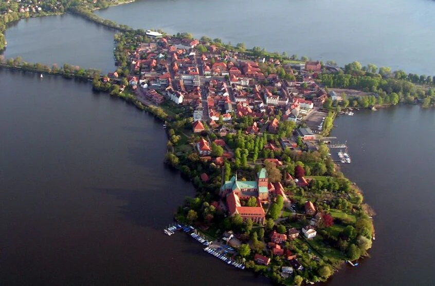
Aerial view of Ratzeburg, a town located on an island surrounded by glacial lakes.
Aerial view of the island city of Ratzeburg situated within the Naturpark Lauenburgische Seen.

Naturpark Lauenburgische Seen history and protected-area timeline

The Naturpark Lauenburgische Seen was founded in 1961 as part of the broader German tradition of designating large rural landscapes as nature parks for conservation, recreation, and regional identity.

Its location along what later became the inner-German border gave it a distinctive geopolitical history, as decades of restricted access along the boundary contributed to relatively low-intensity land use and helped preserve forest and lake ecosystems. Following German reunification, the connection with the Schaalsee Biosphere Reserve in Mecklenburg-Vorpommern transformed the area into a large cross-border protected region, reinforcing its conservation role along the former frontier.

The landscape also carries much older cultural traces, most clearly through the Alte Salzstraße, the medieval trading route between Lüneburg and Lübeck, which still survives in some sections such as near Fredeburg as a recognizable medieval trackway. Historic towns such as Ratzeburg and Mölln, including the Hellbachtal valley associated with Mölln, anchor the park within the regional heritage of the Duchy of Lauenburg.

Naturpark Lauenburgische Seen landscape and geographic character

The landscape of Naturpark Lauenburgische Seen is a classic Weichsel-glaciation young moraine terrain, defined by gentle ridges, kettle lakes, low drumlins, and extensive forest interspersed with open water. Smoothing of older glacial forms is offset by the rolling character of the Schleswig-Holstein Hügelland, giving the park a varied but predominantly low-relief appearance.

Water is the dominant landscape element. The park contains 40 lakes, with the large Ratzeburger See and Schaalsee anchoring the spatial composition and connected by the Schaalsee Canal near Salem. Smaller lakes such as the Pinnsee, Behlendorfer See, Garrensee, Oldenburger See, and Plötscher See add depth and variety to the scene. The Elbe-Lübeck-Kanal loosely bounds the park to the west near Berkenthin and Büchen, while the historic Alte Salzstraße winds through the region between Lüneburg and Lübeck, near Fredeburg still preserved as a medieval trackway.

Naturpark Lauenburgische Seen ecosystems, habitats, and plant life

Ecologically, the park is dominated by extensive forests that cover much of its roughly 470 square kilometers and surround an unusually dense network of lakes. This combination creates a continuous mosaic of forest edges, lake shores, kettle depressions, moraine ridges, and transitional wetland zones typical of the southeastern Schleswig-Holstein young moraine landscape.

Its direct connection to the Biosphärenreservat Schaalsee significantly increases the ecological coherence of the area, allowing habitats, species populations, and ecological processes to extend across state borders into a larger internationally oriented protected region. The presence of the Nordsee-Ostsee watershed means that even small changes in elevation or hydrology within the park can determine whether water ultimately flows toward the North Sea or the Baltic Sea.

Naturpark Lauenburgische Seen conservation status and protection priorities

The primary conservation significance of Naturpark Lauenburgische Seen lies in its scale: with more than 470 square kilometers of forested moraine terrain and 40 lakes, it is among the largest contiguous protected natural landscapes in Schleswig-Holstein. Its direct border with the Biosphärenreservat Schaalsee gives it a cross-state protected-area function along the former inner-German frontier, enhancing habitat connectivity beyond the park itself.

The lake-rich, forest-dominated setting, combined with the hydrological importance of the North Sea-Baltic watershed passing through the park, gives it notable value for freshwater ecology, woodland conservation, and landscape-scale ecological processes typical of the Weichsel-glaciation terrain.

Naturpark Lauenburgische Seen cultural meaning and human context

The cultural context of the park centers on the historic Duchy of Lauenburg region, anchored by the towns of Ratzeburg, the administrative seat of Kreis Herzogtum Lauenburg, and Mölln with its associated Hellbachtal.

A defining cultural element is the Alte Salzstraße, the medieval trade route between Lüneburg and Lübeck that still runs through the park and near Fredeburg remains visible as a medieval trackway.

Monthly climate preview

Measured monthly climate patterns and representative point averages for Naturpark Lauenburgische Seen

Naturpark Lauenburgische Seen Climate Normals, Long-Term Temperature and Precipitation Rhythm

Naturpark Lauenburgische Seen exhibits a measured annual temperature and precipitation rhythm spanning long-term averages from NASA POWER climatology records. Reviewing the complete twelve-month profile provides detailed meteorological context across all recorded monthly cycles.
Annual mean9 °C
0 °C18 °C
Jan
Feb
Mar
Apr
May13°
Jun16°
Jul18°
Aug18°
Sep14°
Oct
Nov
Dec
Warmest month
July

18.1 °C

Coolest month
January

0.3 °C

Wettest month
July

2.5 mm/day

Driest month
April

1.4 mm/day

Park location guide

Geography guide, regional context, and park location map for Naturpark Lauenburgische Seen

Naturpark Lauenburgische Seen park geography, regions, and map view in Germany

Understand where Naturpark Lauenburgische Seen sits in Germany through a broader geographic reading of the surrounding landscape, nearby location context, and its mapped position within the national park landscape.

How Naturpark Lauenburgische Seen fits into Germany

Germany is a federal republic in Western and Central Europe with a population of over 83 million across sixteen constituent states. It is Europe's largest economy by nominal GDP and a major global exporter and importer. The capital is Berlin, and the country borders Denmark, Poland, Czech Republic, Austria, Switzerland, France, Luxembourg, Belgium, and the Netherlands.

Wider geography shaping Naturpark Lauenburgische Seen in Germany

Germany is located in Western and Central Europe, spanning 357,022 km². It borders Denmark to the north, Poland and the Czech Republic to the east, Austria and Switzerland to the south, and France, Luxembourg, Belgium, and the Netherlands to the west. The country has coastlines on the Baltic Sea and North Sea to the north, with the Alps located in the southern region.

Map view of Naturpark Lauenburgische Seen

Use this park location map to pinpoint Naturpark Lauenburgische Seen in Germany, understand its exact geographic position, and read its mapped placement within the surrounding landscape more clearly.

Pigeon | © OpenStreetMap contributors

Location context for Naturpark Lauenburgische Seen

Schleswig-Holstein

Visual exploration of forest ridges, lake networks, and protected moraine terrain

Naturpark Lauenburgische Seen Photos and Glacial Landscape Scenery

Photographic views reveal the glacial lakes, extensive woodlands, and rolling young moraine terrain that define the protected landscape. Examining these visual references helps clarify the unique habitat character and geographical layout of the northern German reserve.

Aerial view of Ratzeburg, a town located on an island surrounded by glacial lakes.

A calm lake surface with a fallen tree trunk protruding from the water, backed by a dense forest under a clear sky.

Park atlas

Compare adjacent glacial landscapes and connected protected territories across northern Germany.

Explore Parks Near Naturpark Lauenburgische Seen and Surrounding Regional Protected Areas

Browse other protected areas and regional nature parks situated near Naturpark Lauenburgische Seen to examine contiguous woodland terrains and lake networks. Continuing through adjacent conservation territories provides broader geographic context for northern German glacial geography.
A watercolor painting showing a soft, panoramic landscape with rolling hills in the background, a small stream winding through a grassy foreground, and a cluster of trees on the right.
Nature reserveSchleswig-Holstein
About 20 km away#1 closest

Northwest

Kannenbruch Nature Reserve in Schleswig-Holstein: A Regional Atlas of Protected Woodland Geography

Mapping the radial forestry lanes and bog-forest ecosystems

Kannenbruch represents a distinctive intersection of cultural history and natural succession within Schleswig-Holstein. The reserve protects a waterlogged, low-lying bog-forest characterized by its deliberate, star-shaped layout of radiating forestry lanes. This structured landscape provides a window into Biedermeier-era spatial planning while supporting a rich diversity of spring-flowering geophytes on its damp, heavy soils.

Area
0.25 km²
Established
1995
Relief
Lowland
Climate
Temperate
Watercolor painting of a wide landscape with green fields, rolling hills, and trees with pink and green foliage.
Protected areaSchleswig-Holstein
About 43 km away#2 closest

Northwest

Leezener Au Protected Area: Glacial Tunnel Valley Geography and Habitat Conservation in Schleswig-Holstein

A mapped overview of glacial river corridors and riparian restoration

Discover the geographic essence of the Leezener Au, a protected river corridor shaped by Ice Age glacial activity in Schleswig-Holstein. This area preserves a mosaic of lowland peat, wet meadows, and forested slopes that serve as a crucial habitat link in the regional Trave river basin.

Established
2005
Relief
Lowland
Climate
Temperate
Scope
Terrestrial
Natural monumentSchleswig-Holstein
About 46 km away#3 closest

Northwest

Kalkberghöhle Natural Monument: Geological Profile and Protected Karst Landscape in Schleswig-Holstein

Mapping a unique gypsum cave and biological refuge

Located in Bad Segeberg, Kalkberghöhle represents a significant karst formation emerging from the young moraine landscape of northern Germany. The site showcases a rare phreatic gypsum cavern morphology and serves as one of the most vital subterranean bat hibernation habitats in Europe. This protected natural monument offers a distinct look into the interaction between salt tectonics and glacial surface geology.

Established
1913
Visitors
42.2K annual
Relief
Upland
Climate
Temperate
Nature reserveLower Saxony
About 46 km away#4 closest

Southwest

Streitmoor Nature Reserve Geography and Mapped Protected Land in Lower Saxony

A study in compact bog and wetland succession

Streitmoor provides a detailed look at a terrestrialized pond moor within the Lüneburg district. The site contains a layered sequence of peat mosses, cottongrass, and woodland, mapping the natural transition between open bog basins and dry forest margins in northwestern Germany.

Area
0.13 km²
Established
1972
IUCN
IV
Relief
Lowland
Nature reserveHamburg
About 47 km away#5 closest

Southwest

Zollenspieker Nature Reserve: Geographic Overview and Protected Riverine Landscapes

Tidal Elbe floodplain and inland brack wetland ecology

Located in the Hamburg borough of Bergedorf, Zollenspieker protects a significant stretch of the tidal Elbe. This nature reserve contains approximately 80 hectares of diverse terrain, from freshwater mudflats exposed at low tide to sheltered oak-dominated forests and old brack wetlands known as Carlsbrack and Riepenburger Brack.

Area
0.8 km²
Established
1988
IUCN
IV
Relief
Lowland
Nature reserveLower Saxony
About 50 km away#6 closest

Southwest

Wittsaal Nature Reserve: Mapped Wetland Geography and Protected Landscape in Lower Saxony

A rare mosaic of moor ponds and swamp woodland

Wittsaal is a specialized nature reserve in the Lüneburg region of Lower Saxony, Germany. The area protects a peat-cut moor pond currently undergoing natural silting, surrounded by willow-dominated swamp woodland, reedbeds, and sedge marshes. This compact site provides a critical, quiet refuge for wetland ecology within a wider landscape of agricultural fields and transitional glacial terrain.

Area
0.13 km²
Established
1985
IUCN
IV
Relief
Lowland
Nature reserveSchleswig-Holstein
About 53 km away#7 closest

Northwest

Tarbeker Moor Nature Reserve and Glacial Peatland Basin Geography

A restored wetland landscape in Schleswig-Holstein, Germany

Tarbeker Moor functions as a crucial nature reserve that showcases the successful rewetting of a former industrial peatland. Located in a shallow glacial meltwater channel north of Bad Segeberg, the park offers a distinct study in landscape recovery, featuring a dense mosaic of open water, floating vegetation, and diverse amphibian habitats.

Area
1.31 km²
Established
2004
A watercolor painting showing a panoramic view of a calm river with a small, vegetated island in the center and pink wildflowers in the foreground.
Nature reserveHamburg
About 54 km away#8 closest

West

Schweenssand Nature Reserve: Protected Elbe Floodplain Geography in Hamburg Germany

Tidal freshwater wetlands, reedbeds, and riverine forest mosaics

Spanning 35 hectares along the Süderelbe, Schweenssand acts as a vital protected area within the Hamburg city boundary. Its geography consists of freshwater tidal flats, mudflats, and ancient-looking floodplain forests that are continuously shaped by the Elbe river tide. This site offers a clear view into the ecological complexity of urban-fringe river landscapes and European Natura 2000 protected zones.

Area
0.4 km²
Established
1993
IUCN
IV
Relief
Lowland

Common questions about visiting, size, designation, and location context for Naturpark Lauenburgische Seen

Naturpark Lauenburgische Seen FAQs for park facts, access, geography, and protected area context

Find quick answers about Naturpark Lauenburgische Seen, including protected-area facts, park geography, trail and visitor context, and how the park fits into its surrounding country and regional landscape.
MoriAtlas Explorer

Continue Your Protected Areas Search Across the Global Atlas

Deepen your exploration by continuing the structured search for national parks and protected areas worldwide. Utilize the comprehensive filtering capabilities to compare different conservation landscapes and refine your understanding of global park geography. Discover more about the distribution and characteristics of protected natural areas.

Global natural geography