

Mori Atlas logo
National parkNorth Button Island National Park

Understand the mapped boundaries and regional natural terrain of this protected island area.

North Button Island National Park: Protected Landscape and Geographic Context in the Andaman and Nicobar Islands

North Button Island National Park is a designated national park situated within the Andaman and Nicobar Islands, an Indian union territory comprising a vast archipelago. This page provides detailed atlas-style insight into the park's protected area status, its precise geographic setting within the Bay of Bengal, and the surrounding natural landscape. Delve into the mapped terrain and regional context to understand the unique identity of this protected island.

marine protected areaisland national parktropical islandAndaman and Nicobar Islandsdugong habitatdeciduous forest

North Button Island National Park

National park

Park overview

Structured park overview, official facts, and landscape profile for North Button Island National Park

North Button Island National Park park facts, protected area profile, and essential visitor context

Review the core facts for North Button Island National Park, including designation, size, terrain, visitor scale, habitats, and operating context in one park-focused overview.

About North Button Island National Park

North Button Island National Park protects a significant portion of the Button Islands group in the northern Andaman archipelago. The park's establishment in 1979 reflected India's growing commitment to preserving the unique ecosystems of its remote island territories during the latter decades of the twentieth century. The Andaman and Nicobar Islands represent a biodiversity hotspot of considerable global significance, containing species found nowhere else on Earth due to the archipelago's long-term geographic isolation.

The park encompasses the island itself along with the surrounding marine environment, recognizing that effective conservation of island ecosystems requires protection of both terrestrial and oceanic components. This integrated approach is particularly important for North Button Island, where the marine waters support species that are dependent on healthy coastal and nearshore habitats. The park's location in the Andaman Sea places it within a region of significant marine diversity, with coral reefs, seagrass beds, and open water environments all contributing to the overall ecological value of the protected area.

Access to the park is facilitated through the nearby settlement of Long Island, which serves as a launching point for visits to the Button Islands. The park's relative remoteness within the Andaman archipelago contributes to its ecological integrity by limiting development pressure and human disturbance, though this same remoteness has historically limited scientific study and visitor access. The tropical setting ensures that the park experiences warm conditions year-round, with seasonal variation primarily expressed through monsoon rainfall patterns rather than temperature fluctuations.

Quick facts and research context for North Button Island National Park

North Button Island National Park was formally designated in 1979 and is situated in the Andaman district of the Andaman and Nicobar Islands union territory. The park protects both the terrestrial environment of North Button Island and the surrounding marine waters within its boundaries. The island forms part of the Button Islands group, a collection of small islands located in the Andaman Sea. The predominant forest type on the island is deciduous woodland, though coastal vegetation zones also occur. The park experiences a tropical climate with high humidity and seasonal monsoon influences.

Protection and recognition

Tracking documented management frameworks, international records, and official conservation boundaries

North Button Island National Park Protected Area Designation and Official Status

Verification of North Button Island National Park involves tracking documented protection status, international database listings, and official regional designations. Researchers can analyze structured conservation parameters to understand the formal administrative framework and documented records of the island territory.

Protection details

Transboundary protection
No
Park context

Deeper park guide and search-rich context for North Button Island National Park

North Button Island National Park history, landscape, wildlife, and travel context

Explore North Button Island National Park through its history, landscape character, ecosystems, wildlife, conservation priorities, cultural context, and seasonal travel timing in a structured park guide built for atlas discovery and search intent.

Why North Button Island National Park stands out

North Button Island National Park is best known for its significant marine mammal populations, particularly the dugong and various dolphin species that inhabit the surrounding waters. The dugong, a marine mammal that feeds on seagrass beds, represents one of the most notable conservation priorities for this protected area, as these animals face significant threats throughout their range across the Indo-Pacific. The park's waters also serve as a habitat for dolphins, which can be observed moving through the island's coastal zones. Additionally, the park is recognized for its deciduous forest ecosystem, which while not as biologically distinctive as the marine environment, provides important terrestrial habitat context for the island system.

North Button Island National Park history and protected-area timeline

North Button Island National Park was established in 1979 as part of India's expanding network of national parks during the conservation movement of the 1970s and 1980s. The creation of this protected area reflected growing awareness of the unique biodiversity values present in the Andaman and Nicobar Islands, an archipelago that had received limited formal protection until the mid-twentieth century. The park was designated to preserve both the terrestrial environment of North Button Island and the surrounding marine ecosystem, acknowledging the interconnected nature of island ecology.

The Andaman and Nicobar Islands came under Indian administration following independence in 1947, and the subsequent decades saw gradual expansion of protected area coverage across the territory. North Button Island's inclusion within this network represented recognition of its ecological significance, particularly regarding marine species such as the dugong that depend on coastal habitats. The Button Islands group, of which North Button Island is a member, had been identified as an area of biological importance warranting protection. The establishment of the park also served to formalize boundaries and management frameworks for the island, providing a legal basis for conservation activities and resource management.

North Button Island National Park landscape and geographic character

North Button Island presents a characteristic island landscape shaped by its tropical marine setting and humid climatic conditions. The island's terrain consists primarily of gently undulating land rising from coastal zones to a modest central elevation, typical of the smaller islands in the Andaman archipelago. The island covers approximately 19.5 hectares in total area, making it one of the smaller islands within the Button Islands group.

Deciduous forest dominates the island's interior, creating a green canopy that characterizes the terrestrial environment. The forest composition reflects the tropical location and seasonal rainfall patterns of the Andaman region. Coastal areas feature beach vegetation and transitional zones where terrestrial and marine ecosystems interact. The shoreline of North Button Island provides the interface between the island's land environment and the surrounding marine waters, with shallow coastal areas and reef formations present in the vicinity. The surrounding marine environment extends outward from the island, encompassing both nearshore waters and deeper areas of the Andaman Sea.

North Button Island National Park ecosystems, habitats, and plant life

The ecological character of North Button Island National Park is defined by the intersection of tropical deciduous forest ecosystems with a rich marine environment. The island's deciduous forest represents a vegetation type adapted to the seasonal climate patterns of the Andaman region, with trees that lose their leaves during the dry season before regenerating foliage with the return of monsoon rains. This forest provides habitat for terrestrial species, though the park's primary ecological significance lies in its marine components.

The surrounding marine environment supports a diversity of habitat types including seagrass beds, coral communities, and open water areas. The seagrass beds that occur in the shallow waters around North Button Island are particularly important as they provide the primary food source for dugongs, large marine mammals that graze on these underwater plants. The marine ecosystem also supports populations of dolphins that move through the Andaman Sea, using the coastal waters around the island as feeding and transit areas. Water monitoring lizard populations occur in the coastal zones, utilizing the interface between land and water environments. The overall ecological profile reflects the tropical marine biodiversity that makes the Andaman and Nicobar Islands one of India's most ecologically significant regions.

North Button Island National Park wildlife and species highlights

The wildlife of North Button Island National Park is most notable for its marine mammal populations, particularly the dugong and various dolphin species that inhabit the surrounding waters. The dugong represents the flagship species of the park, a marine mammal that can grow to lengths of around three meters and feeds almost exclusively on seagrass. These animals are considered vulnerable globally and face significant threats from habitat loss, entanglement in fishing gear, and boat strikes throughout their range. The waters around North Button Island provide important habitat for dugong populations, with the seagrass beds offering essential feeding resources.

Dolphin species found in the park's waters include several types that are known to occur in the Andaman Sea region. These intelligent marine mammals can be observed swimming near the island, particularly during certain seasons when they may be more frequently encountered. The park also supports populations of water monitor lizards, large reptiles that are commonly found in wetland and coastal areas throughout South and Southeast Asia. These lizards are adept swimmers and frequently occur in areas where freshwater meets saltwater. The combination of marine mammals, reptiles, and the various fish and invertebrate species that inhabit the surrounding waters creates a wildlife assemblage of considerable conservation significance.

North Button Island National Park conservation status and protection priorities

North Button Island National Park contributes significantly to India's conservation estate by protecting a portion of the Andaman and Nicobar Islands' unique biodiversity. The park's designation in 1979 established formal protection for an area that contains species of conservation concern at both national and international levels. The dugong population represents a particular conservation priority, as this species is listed as vulnerable on the IUCN Red List and faces declining numbers throughout much of its range across the Indo-Pacific region.

The marine protected area framework that the park operates under helps to safeguard critical habitat for dugongs and other marine species by limiting potentially harmful activities within the park boundaries. The Andaman and Nicobar Islands have been recognized as a region of significant biodiversity value, with numerous endemic species occurring only in this archipelago. North Button Island's protected status ensures that its ecological values are maintained against development pressures and resource exploitation that might otherwise threaten the island's natural environment. The park also contributes to the broader conservation network that protects key habitats throughout the Andaman archipelago, creating a connected system of protected areas that support regional biodiversity conservation.

North Button Island National Park cultural meaning and human context

North Button Island National Park is situated within the territory of the Andaman and Nicobar Islands, a region with a complex human history involving indigenous peoples, colonial powers, and post-independence development. The indigenous peoples of the Andaman Islands, including various tribal groups with long histories in the archipelago, have maintained connections to the marine environment surrounding the islands for generations. While North Button Island itself is not known to have significant permanent human habitation, the broader Andaman and Nicobar Islands contain communities whose traditional relationships with the sea and coastal environments shape regional cultural context.

The Button Islands group has been part of the Andaman archipelago's geographic understanding since well before formal administrative systems were established. The islands have experienced various phases of exploration, mapping, and scientific investigation during the colonial and post-colonial periods. The establishment of the national park reflects a contemporary approach to managing the island's natural values within a framework of protected area management. The park exists within a broader context of island conservation and sustainable development that characterizes contemporary approaches to the Andaman and Nicobar Islands.

Top sights and standout views in North Button Island National Park

North Button Island National Park offers visitors the opportunity to experience one of India's more remote island protected areas, where tropical forest meets productive marine waters. The chance to observe dugongs in their natural environment represents the park's most distinctive wildlife viewing opportunity, as these gentle marine mammals are rarely encountered elsewhere in Indian waters. Dolphins can also be spotted in the surrounding waters, particularly during favorable conditions. The island's deciduous forest provides a different nature experience, with birdlife and the occasional water monitor lizard offering terrestrial wildlife encounters.

The park's location within the Andaman archipelago places it in a region of exceptional marine biodiversity, with coral reefs, clear waters, and rich underwater life contributing to its appeal. The best months for visiting, from December to March, correspond with more comfortable weather conditions and reduced rainfall that facilitate outdoor activities and wildlife observation. The relative remoteness of the park, accessible primarily through boat travel from nearby islands, adds to the sense of exploration and adventure that characterizes a visit to North Button Island.

Best time to visit North Button Island National Park

The optimal period for visiting North Button Island National Park extends from December through March, when the region experiences its dry season and more comfortable climatic conditions prevail. During these months, rainfall is reduced compared to the monsoon season, and temperatures remain warm but less extreme than during the peak summer period. The dry season conditions create favorable opportunities for wildlife observation, as animals may be more active in the less humid atmosphere and visibility conditions improve for marine activities.

The monsoon season in the Andaman and Nicobar Islands typically runs from May through November, bringing heavy rainfall and sometimes rough sea conditions that can limit access to the park and affect visitor experiences. The transitional periods around November and April may offer a compromise between seasonal conditions, though the precise timing of weather patterns can vary from year to year. Visitors planning trips to North Button Island should consider that the park's island location means that weather conditions on the water can significantly affect access, and boat services may be limited during periods of inclement weather.
Monthly climate preview

Long-term temperature ranges and monthly precipitation rhythm for representative coordinates

North Button Island National Park Climate Normals and Annual Weather Patterns

Long-term representative records show sustained monthly temperatures paired with distinct shifts in precipitation across the coordinate point. Examining the complete twelve-month profile reveals detailed historical averages for informed geographic analysis.
Annual mean28 °C
26 °C30 °C
Jan26°
Feb27°
Mar28°
Apr30°
May29°
Jun28°
Jul28°
Aug28°
Sep27°
Oct27°
Nov28°
Dec27°
Warmest month
April

29.5 °C

Coolest month
January

26.3 °C

Wettest month
July

14.2 mm/day

Driest month
February

0.4 mm/day

Park location guide

Geography guide, regional context, and park location map for North Button Island National Park

North Button Island National Park park geography, regions, and map view in India

Understand where North Button Island National Park sits in India through a broader geographic reading of the surrounding landscape, nearby location context, and its mapped position within the national park landscape.

How North Button Island National Park fits into India

India is a South Asian country bordered by the Indian Ocean, Arabian Sea, and Bay of Bengal. It shares land borders with Pakistan, China, Nepal, Bhutan, Bangladesh, and Myanmar. The country has a population of over 1.4 billion people and operates as a federal parliamentary republic with its capital in New Delhi.

Wider geography shaping North Button Island National Park in India

India occupies the Indian subcontinent in South Asia, bordered by the Arabian Sea to the southwest, the Bay of Bengal to the southeast, and the Indian Ocean to the south. It shares land borders with Pakistan to the west, China, Nepal, and Bhutan to the north, and Bangladesh and Myanmar to the east. The territory also includes the Andaman and Nicobar Islands in the Indian Ocean.

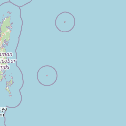
Map view of North Button Island National Park

Use this park location map to pinpoint North Button Island National Park in India, understand its exact geographic position, and read its mapped placement within the surrounding landscape more clearly.

Pigeon | © OpenStreetMap contributors

Location context for North Button Island National Park

Andaman and Nicobar Islands
Park atlas

Trace the Andaman and Nicobar Islands' Marine Protected Landscapes and Regional Park Geography

Explore Related National Parks and Protected Areas Near North Button Island National Park

Discover other island national parks and protected marine areas within the Andaman and Nicobar Islands, expanding your exploration beyond North Button Island National Park. Compare the diverse protected landscapes and coastal ecosystems of the archipelago, tracing the unique conservation geography of India's remote island chains.
National parkAndaman and Nicobar
About 6.5 km away#1 closest

Southwest

Middle Button Island National Park: National Park within Andaman and Nicobar's Geography

Explore protected landscape context and mapped park boundaries.

Middle Button Island National Park represents a significant protected natural landscape, offering users a focused entry point for geographic discovery. As a designated national park, it contributes distinct mapped boundaries and terrain characteristics to the Andaman and Nicobar region's atlas data. Understanding its specific identity helps contextualize the broader protected-area network and regional geography. This page details the park's role as a conserved territory, vital for those seeking structured landscape and geography information.

Area
64 km²
Established
1979
Relief
Lowland
Climate
Tropical
National parkAndaman and Nicobar Islands
About 12 km away#2 closest

Southwest

South Button Island National Park: Mapped Boundaries and Regional Protected Landscape

Key National Park in the Andaman and Nicobar Islands

South Button Island National Park is a protected natural area offering critical insight into the geography of the Andaman and Nicobar Islands. This detailed view focuses on its mapped boundaries and its significance as a national park within this Indian archipelago. Understanding its position within the regional geography provides essential context for exploring protected lands and natural landscapes across the Andaman and Nicobar Islands.

Area
5 km²
Relief
Lowland
Climate
Tropical
Access
Moderate access
Wildlife reserveAndaman and Nicobar Islands
About 45 km away#3 closest

North

Cuthbert Bay Wildlife Sanctuary: Coastal Habitat and Sea Turtle Nesting Ground

Eastern Middle Andaman protected coastal geography

Cuthbert Bay Wildlife Sanctuary covers 5.8 square kilometres of critical coastal terrain along the eastern Middle Andaman coastline. Renowned for its concentration of sea turtle nesting beaches, the reserve supports diverse coastal ecosystems ranging from open sand to inland forest patches. It serves as a compact but vital ecological anchor within the broader landscape of the Andaman and Nicobar Islands.

Area
5.8 km²
Established
1997
IUCN
IV
Scope
Terrestrial
Wildlife reserveAndaman and Nicobar Islands
About 49 km away#4 closest

Northwest

Flat Island Wildlife Sanctuary: Protected Island Geography in the Andaman and Nicobar Islands

Coastal wildlife reserve and isolated island terrain

Flat Island Wildlife Sanctuary stands as a distinct, low lying protected area within the Andaman and Nicobar Islands. Its compact oval shape and shoreline focused landscape provide a clear example of the archipelago's small scale, uninhabited marine reserves. This protected island serves as a vital geographic marker for those mapping the diverse coastal habitats found across the Bay of Bengal.

Area
2.48 km²
Relief
Lowland
Climate
Tropical
Access
Remote access
National parkAndaman and Nicobar Islands
About 58 km away#5 closest

Southwest

Mount Harriet National Park: National Park Mapping and Protected Landscape Identity

Explore its endemic biodiversity and mountain forest terrain.

Mount Harriet National Park provides a deep dive into a unique protected landscape, offering detailed insights into its geography, terrain, and ecological significance within the Andaman and Nicobar Islands. As a national park, it showcases a remarkable combination of mountainous forest ecosystems and coastal environments, serving as a vital habitat for numerous endemic species. Understanding its mapped boundaries and regional geographic context reveals why this protected area is a key point of interest for atlas-based natural landscape exploration.

Area
46.62 km²
Established
1979
IUCN
II
Relief
Mountain
Wildlife reserveAndaman and Nicobar Islands
About 65 km away#6 closest

Southwest

Defence Island Wildlife Sanctuary: Protected Geography and Island Ecosystems in the Andaman Archipelago

A remote wildlife reserve within the South Andaman district

Defence Island Wildlife Sanctuary represents a key protected landform within the Andaman and Nicobar union territory. Characterized by its coastal littoral habitats and dense tropical interior, this uninhabited island reserve serves as a significant site for regional biodiversity and landscape conservation efforts in the Bay of Bengal.

Area
5.04 km²
Water
Water-dominated
Season
Year-round
Marine protected areaIndia
About 73 km away#7 closest

Southwest

Rani Jhansi Marine National Park: An Indian Marine Protected Area for Geographic Discovery

Explore mapped marine boundaries and regional landscape context.

Rani Jhansi Marine National Park stands as a crucial marine protected area within India, offering a unique focus on aquatic ecosystems and coastal geography. This dedicated space allows for detailed exploration of its specific marine protected boundaries and its significance within the broader landscape of India's natural heritage. Delve into the mapped geography and protected areas of this vital conservation zone for a deeper understanding of its environmental role.

Area
256 km²
Established
1996
IUCN
II
Climate
Tropical
Protected areaAndaman and Nicobar Islands
About 74 km away#8 closest

Northwest

Interview Island Protected Area: Geography, Forested Plateau, and Island Map

A remote wilderness sanctuary in the Andaman archipelago

Interview Island encompasses a secluded, 23 kilometer long landscape characterized by dense tropical forests and a rising southern plateau. This protected area stands out for its feral elephant population and near-undisturbed coastal environment, providing a compelling focus for geographic exploration and study of the Andaman island chain.

Area
101 km²
Established
1997
Relief
Upland
Water
Major water bodies

Common questions about visiting, size, designation, and location context for North Button Island National Park

North Button Island National Park FAQs for park facts, access, geography, and protected area context

Find quick answers about North Button Island National Park, including protected-area facts, park geography, trail and visitor context, and how the park fits into its surrounding country and regional landscape.
MoriAtlas Explorer

Continue Your Protected Areas Search Across the Global Atlas

Deepen your exploration by continuing the structured search for national parks and protected areas worldwide. Utilize the comprehensive filtering capabilities to compare different conservation landscapes and refine your understanding of global park geography. Discover more about the distribution and characteristics of protected natural areas.

Global natural geography