
Mori Atlas logo
Nature reserveØstdelen af Læsø

Dynamic coastal formations and protected moorland terrain across the eastern tip of Læsø Island

Østdelen af Læsø Nature Reserve: Coastal Geography, Barrier Islands, and Heath-Mire Landscapes

Østdelen af Læsø comprises a protected expanse of coastal heath, high dune ridges, and evolving barrier islands in the Kattegat sea. This nature reserve provides a critical study of Danish coastal dynamics, showcasing a mosaic of beach ridges and wetland hollows that have formed over centuries. Explore the mapped boundaries of the reserve, from the prominent dunes of Danzigmand Klit to the active accretion of the Bløden Hale peninsula and offshore gravel formations.

coastal heathdunesbarrier islandsbeach ridgesheath and miresalt marsh
A stylized digital illustration of a scenic valley featuring a waterfall, a winding river, grassy fields with grazing cattle, and coniferous trees under a soft, pastel-colored sky.

Østdelen af Læsø

Nature reserve

Park overview

Structured park overview, official facts, and landscape profile for Østdelen af Læsø

Østdelen af Læsø park facts, protected area profile, and essential visitor context

Review the core facts for Østdelen af Læsø, including designation, size, terrain, visitor scale, habitats, and operating context in one park-focused overview.

About Østdelen af Læsø

Østdelen af Læsø occupies the easternmost portion of Læsø, an island in the Kattegat between Denmark's Jutland coast and northern Sweden. The protected area represents one of the clearer examples in Denmark of a landscape where natural processes, including dune formation, beach ridge buildup, heath vegetation succession, and sea-driven erosion and deposition, continue to shape the terrain with minimal human interference. Apart from a small number of summer cottages, the land has been allowed to develop on its own terms since conservation was enacted in 1963.

The northern coastline is edged by the dunes of Danzigmand Klit, the tallest of the dune formations within the reserve, which offers a wide view southward across Syrsig and the surrounding heath. Inland, the terrain shifts to a flat mosaic of old beach ridges (rimmer) and intervening wet hollows (dobber), creating the classic Danish coastal heath-mire structure. Along the shore itself, the Bløden Hale peninsula extends into the sea as an active accretion zone, where sand and gravel have been deposited by the sea in recently formed beach ridges only a few decades old.

The ecological value of the site extends beyond the land. The shallow marine areas south and west of the barrier islands and the whole of Bovet Bugt are designated as a wildlife reserve, contributing to seasonal protection for waterbirds. As a result, Østdelen af Læsø functions as a compound protected area, combining terrestrial conservation, Natura 2000 habitat protection, and marine bird protection in a single connected landscape.

Quick facts and research context for Østdelen af Læsø

Østdelen af Læsø is a 266-hectare protected coastal landscape on the eastern end of the Danish island of Læsø. The reserve was established through conservation in 1963 and includes beach, dune, and heath habitats along with offshore barrier islands. It forms part of Natura 2000 area No. 9, which covers the salt marshes and shallow sea around Læsø. Beyond its terrestrial habitats, the surrounding marine zone is also designated as a wildlife reserve supporting breeding and resting waterbirds.

Protection and recognition

Review the mixed protection scope and official designation records for Østdelen af Læsø.

Østdelen af Læsø Protection Status and Documented Conservation Scope

Documented protection records for Østdelen af Læsø outline a mixed conservation scope and governance framework. Official records compile available management data and designation details without external recognition sources.

Protection details

Protection scope
Mixed
Transboundary protection
No
Park context

Deeper park guide and search-rich context for Østdelen af Læsø

Østdelen af Læsø history, landscape, wildlife, and travel context

Explore Østdelen af Læsø through its history, landscape character, ecosystems, wildlife, conservation priorities, cultural context, and seasonal travel timing in a structured park guide built for atlas discovery and search intent.

Why Østdelen af Læsø stands out

The area is best known for its mosaic of active coastal landscapes: high dunes at Danzigmand, a broad flat heath-mire wetland in Syrsig, and the young, still-growing barrier islands of Store Knot, Lille Knot, and Knogen. It is equally recognized as a key site for seabird colonies in Denmark, particularly for hosting the country's only larger breeding colony of great black-backed gull (svartbag) on the Knots. The combination of traditional cliff heath vegetation and a dynamic, newly formed coastal margin makes the area distinctive among Danish protected landscapes.
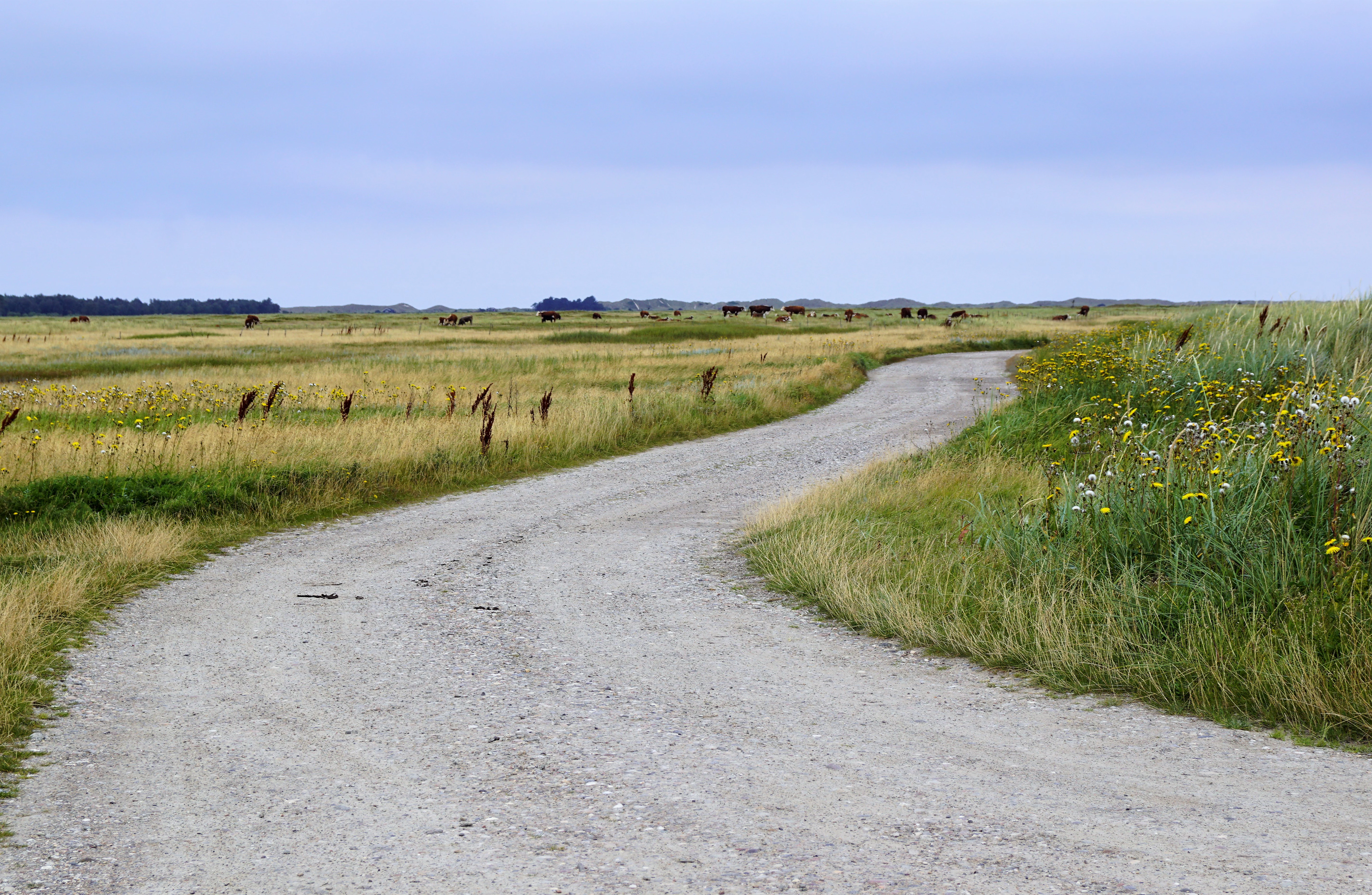
A winding gravel road leads through a flat, grassy coastal meadow under a pale, overcast sky.
A gravel path winds through the open coastal landscape of Østdelen af Læsø, where grazing livestock can be seen in the distance.

Østdelen af Læsø history and protected-area timeline

The area was formally protected in 1963, covering 266 hectares of beach, dune, and heathland on the eastern part of Læsø. The protection was part of Denmark's broader nature conservation effort, and the site has since been integrated into the European Natura 2000 network as part of site No. 9, which focuses on the strandenge (salt marsh), coastal heath, and shallow sea environments around Læsø.

The name Danzigmand Klit carries a piece of local maritime history: the dune is named after a ship from Danzig that was wrecked at that location in 1741. Over the centuries, the eastern tip of Læsø has continued to shift with the sea. While the northern coast has suffered long stretches of erosion caused by ocean currents, the Bløden area has been built up by ongoing deposition of sand and gravel, producing the youngest part of the island in geological terms. The marine zone offshore has more recently been designated a wildlife reserve in recognition of its importance to breeding and migrating waterbirds.

Østdelen af Læsø landscape and geographic character

The landscape of Østdelen af Læsø is shaped almost entirely by the interplay between the sea and the sandy shore. Along the northern edge, Danzigmand Klit stands as the highest of the dunes that line the protected area, offering an elevated vantage point over the flat terrain to the south. South of the dunes lies Syrsig, a large, level expanse where old beach ridges alternate with small pools and wet hollows, characteristic of the classic Danish coastal heath-mire environment.

At the very eastern end of the island, Syrodde forms the northeasternmost point of Læsø. Just south of it, the Bløden Hale peninsula juts out into the Kattegat, and beyond it the barrier islands of Store Knot, Lille Knot, and Knogen form a small but growing chain. These islands are among the youngest geological features on Læsø, having been added by the sea in recent centuries, with their southernmost beach ridges sometimes less than a century old.

The coastal dynamics of the area are notable for their contrast. The northern coast experiences long stretches of erosion as currents cut into the shore, while Bløden and the Knots are areas of active buildup, where regular beach ridge patterns can be seen clearly in the landscape. South of the Knots, sand and stone flats occasionally surface that do not appear on standard maps, some fleeting, others more lasting, illustrating how active the seabed remains here.
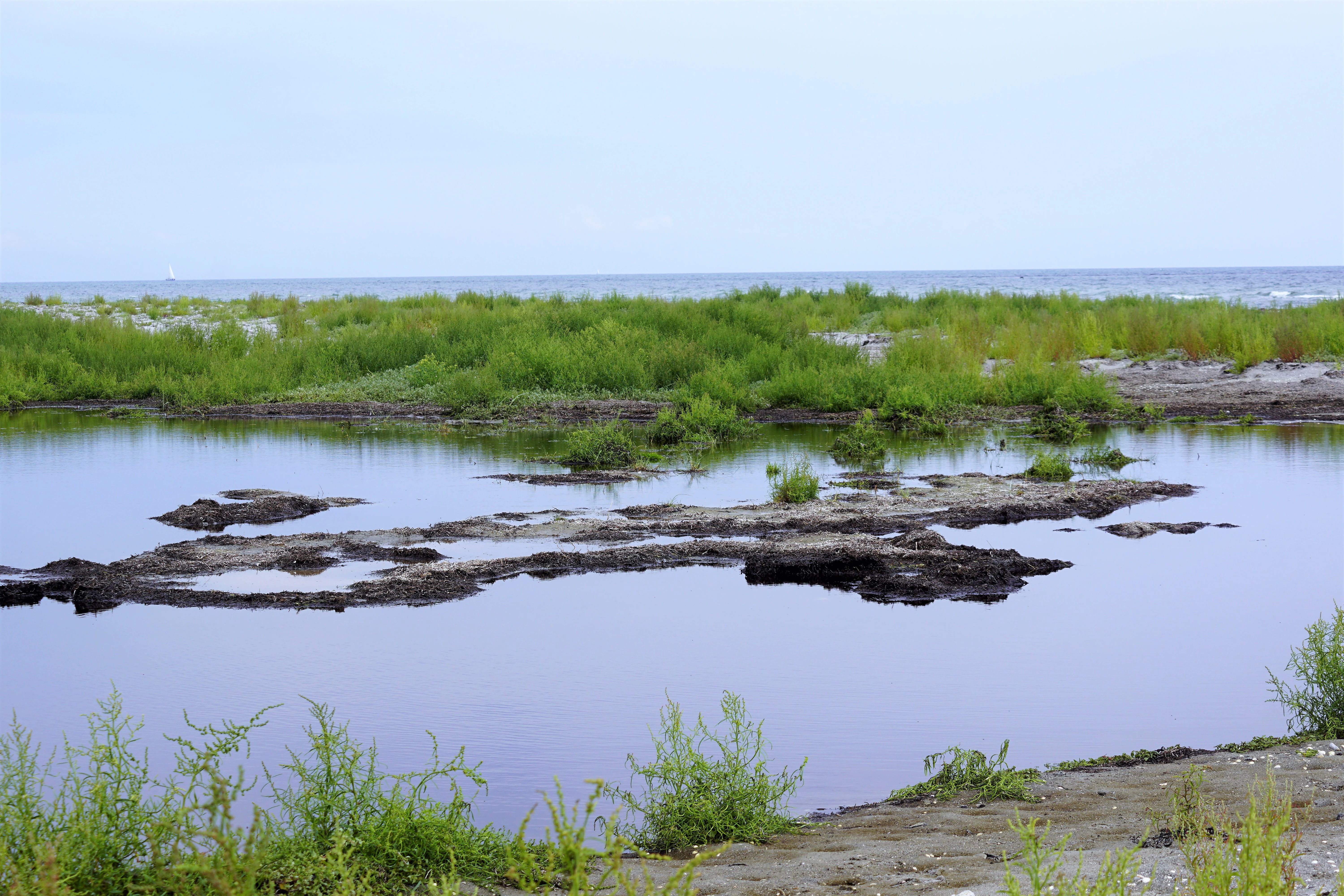
A calm, shallow coastal lagoon with dark water, low-lying green marsh vegetation, and a distant sea horizon under a pale sky.
A coastal lagoon at Bløden Hale in the Østdelen af Læsø protected area.

Østdelen af Læsø ecosystems, habitats, and plant life

The terrestrial vegetation of the reserve follows the well-known pattern of Danish coastal heath on former beach ridges. The raised ridges (rimmer) support heather, crowberry (revling), and creeping willow, while the deeper, wetter areas between them (dobber) host marsh spurge (mosepors), cross-leaved heath (klokkelyng), and the grass blåtop. Several more sensitive species, including sundews and the early-purple orchid (plettet gøgeurt), also occur in these mires.

On the Bløden Hale peninsula, vegetation transitions into salt marsh (strandeng) communities. Here, dense-flowered sea lavender (tætblomstret hindebæger), sea wormwood (strandmalurt), sea centaury (strandtusindgylden), and sand sedge (sandkryb) are characteristic. Portions of the salt marsh are fenced for cattle grazing, which keeps the habitat open and prevents succession into denser vegetation, while ungrazed areas support larger stands of sea club-rush (strandkogleaks).

The marine environment to the south and southwest, with its shallow shelves, stones, and small islets, functions as a rich feeding ground that supports both resident and migratory waterbird populations.
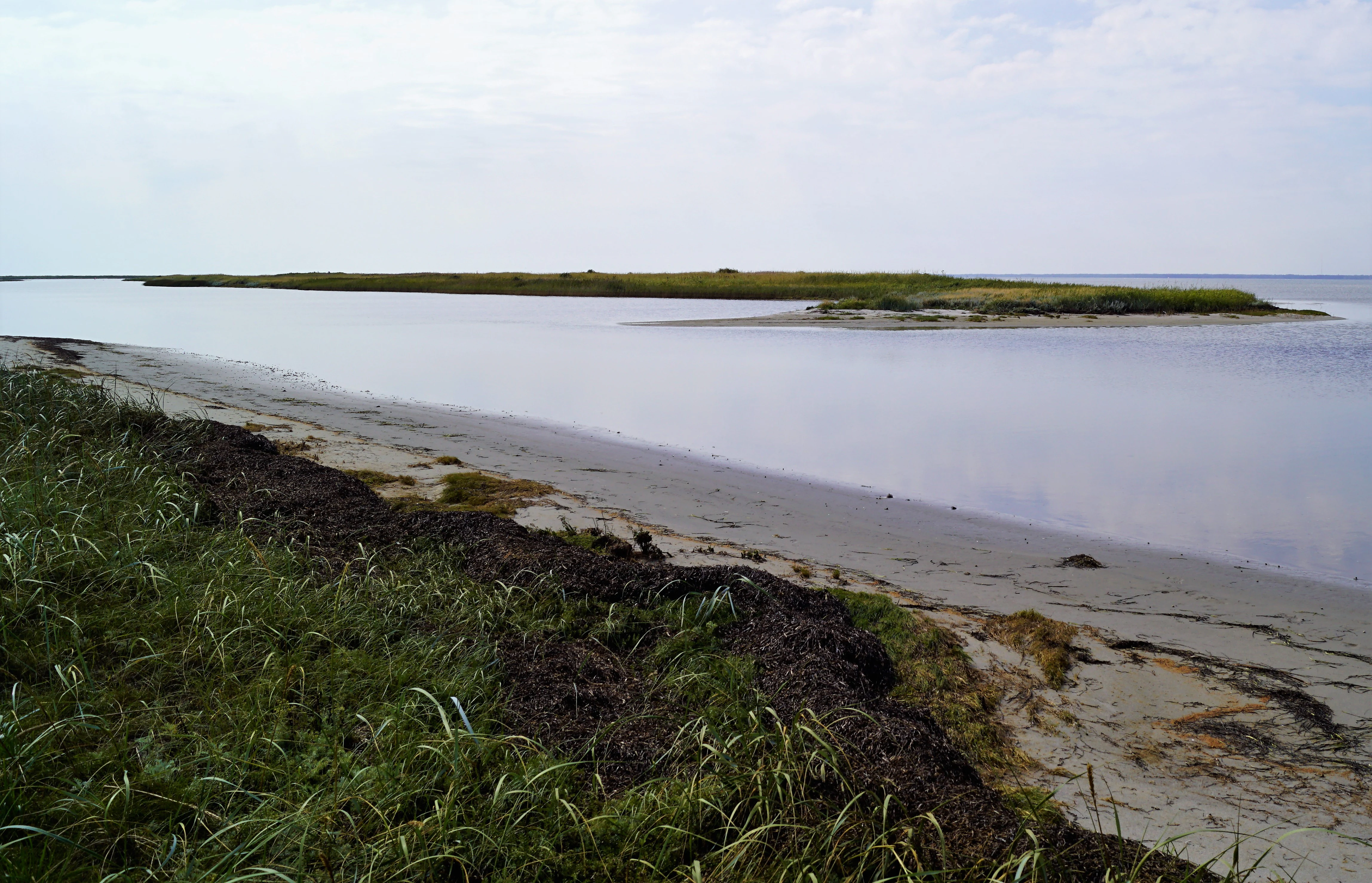
A low-lying coastal landscape with a sandy beach, shoreline vegetation, and a narrow grass-covered islet in the calm water under an overcast sky.
A coastal view of the Store Knot area in Østdelen af Læsø.

Østdelen af Læsø wildlife and species highlights

Wildlife is one of the most distinctive features of Østdelen af Læsø. The shallow waters around the Knot barrier islands and the broader Bovet Bugt are a productive feeding ground for a wide range of seabirds and waterfowl, and the area has been formally recognized with a wildlife reserve designation to give the birds undisturbed space for feeding, roosting, and breeding.

The Knots themselves host Denmark's only larger breeding colony of great black-backed gull (svartbag), and the area also serves, sometimes only sporadically, as a breeding site for common eider, mallard, common shelduck, oystercatcher, ringed plover, red-breasted merganser, common redshank, herring gull, common gull, sandwich tern, common tern, little tern, Arctic tern (splitterne), mute swan, and curlew. The visible seal haul-out (sælhunderevet) northwest of Danzigmand also offers chances to observe seals from the dune top.

During spring migration, the area becomes especially active with passerines and other small birds passing through. From the summit of Danzigmand, birdwatchers have a wide vantage point to observe seabirds offshore, coastal waders along the shoreline, and seasonal migrants in the heath and scrub behind the dunes.

Østdelen af Læsø conservation status and protection priorities

Østdelen af Læsø has been protected since 1963, initially through traditional Danish conservation law covering 266 hectares of beach, dune, and heath. Its conservation status has since been strengthened by its inclusion in the European Natura 2000 network as part of area No. 9, which also encompasses the strandenge on Læsø and the sea to the south. This dual designation reflects both the terrestrial and marine ecological importance of the site.

In addition to terrestrial protection, the waters south and west of the Knot island chain and the whole of Bovet Bugt have been designated as a wildlife reserve, giving waterbirds formal protection for both resting and breeding. The protection strategy combines habitat conservation (preserving active dune, beach ridge, and heath-mire processes), species protection (especially breeding seabirds and seals), and landscape-scale connectivity between land and sea.

Long-running civilian and governmental management efforts include seasonal grazing by cattle on parts of the salt marsh to maintain open vegetation, and regulation of visitor and cottage pressure to keep the broader landscape in a condition where natural dynamics continue to dominate over built infrastructure.

Østdelen af Læsø cultural meaning and human context

The protected area has a layered cultural context rooted in its maritime and island history. The name Danzigmand Klit preserves local memory of a 1741 maritime event, when a ship from the Baltic port of Danzig was wrecked along the Læsø coast. Such place names, tied to individual shipwrecks, are a feature of many Danish coastal dune landscapes and connect natural sites directly to long histories of North Sea and Kattegat navigation.

The Læsø island itself has a long history of small-scale habitation, salt production, and maritime livelihoods. In the eastern part of the island, however, the building footprint remains very limited: apart from a small number of summer cottages, the landscape has been left largely to its natural development, which reflects a deliberate cultural choice to preserve the area as an open, lightly managed coastal wilderness within an inhabited island setting. The continuing use of cattle grazing on portions of the salt marsh is another element of that long-standing human-landscape relationship.

Top sights and standout views in Østdelen af Læsø

Østdelen af Læsø offers a compact but information-rich set of highlights: the panoramic dune view from Danzigmand Klit, the broad Syrsig heath-mire plain to the south, the actively accreting Bløden Hale peninsula with its distinctive beach ridge formations, and the young barrier islands of Store Knot, Lille Knot, and Knogen. Offshore, the wildlife reserve waters around the Knots and Bovet Bugt add a strong marine dimension, while the seal haul-out visible from Danzigmand offers a memorable wildlife encounter above and below the waterline.

In ecological terms, the area is a reference example of the Danish coastal heath zone, showing the rimmer-dobber mosaic with characteristic heather, crowberry, and creeping willow on the ridges and marsh spurge and cross-leaved heath in the hollows. The presence of Denmark's only significant breeding colony of great black-backed gull on the Knots elevates the area's national importance well beyond its modest 266 hectares.

Best time to visit Østdelen af Læsø

The character of Østdelen af Læsø shifts meaningfully with the seasons, and spring and early summer tend to be especially rewarding for visitors interested in the area's birdlife. During the spring migration, a wide variety of waterbirds, seabirds, and smaller passerines pass through or settle along the shoreline and heath, and this is also the key period for observing breeding terns, oystercatchers, and ringed plovers on the Knots. Late spring and early summer are also when coastal heath plants are most visibly in bloom, adding color to the Syrsig moor.

Summer brings the most settled weather for walking the dunes, but the area remains quiet at any time of year due to its low level of development. Late summer and early autumn are favorable for observing seals at the haul-out near Danzigmand and for general landscape photography as the light softens over the heath and shingle. Winter brings a stark, exposed quality to the dunes, and storm-driven erosion along the northern coast can be especially dramatic, though visitors should be aware that this is the most weather-sensitive season for accessing exposed coastal points.

Monthly climate preview

Long-term representative temperature and precipitation patterns across twelve months

Østdelen af Læsø Climate Normals and Average Annual Weather by Month

Representative coordinates record mean monthly temperatures from 1.27 degrees Celsius to 17.39 degrees Celsius alongside fluctuating daily precipitation rates from 1.83 mm to 3.51 mm. Reviewing the complete twelve-month climatology profile reveals comprehensive monthly data variations for long-term regional analysis.
Annual mean9 °C
1 °C17 °C
Jan
Feb
Mar
Apr
May11°
Jun15°
Jul17°
Aug17°
Sep14°
Oct10°
Nov
Dec
Warmest month
August

17.4 °C

Coolest month
February

1.3 °C

Wettest month
October

3.5 mm/day

Driest month
April

1.8 mm/day

Park location guide

Geography guide, regional context, and park location map for Østdelen af Læsø

Østdelen af Læsø park geography, regions, and map view in Denmark

Understand where Østdelen af Læsø sits in Denmark through a broader geographic reading of the surrounding landscape, nearby location context, and its mapped position within the national park landscape.

How Østdelen af Læsø fits into Denmark

Denmark is a constitutional monarchy and Nordic country in Northern Europe. It is the southernmost of the Scandinavian countries, bordering Germany to the south, Norway to the north, and Sweden to the southwest. The country consists of the Jutland peninsula and an archipelago of islands, with Copenhagen as its capital and largest city. Denmark has a population of over 6 million and is characterized by flat, arable land, sandy coasts, and a temperate climate.

Wider geography shaping Østdelen af Læsø in Denmark

Denmark occupies the Jutland peninsula and roughly 406 islands in Northern Europe. It is situated between the North Sea to the west and the Baltic Sea to the east. The country borders Germany to the south and is connected to Sweden via the Øresund Bridge. Denmark is predominantly flat terrain with low elevation, the highest point being Møllehøj at 170.86 meters.

Map view of Østdelen af Læsø

Use this park location map to pinpoint Østdelen af Læsø in Denmark, understand its exact geographic position, and read its mapped placement within the surrounding landscape more clearly.

Pigeon | © OpenStreetMap contributors

Location context for Østdelen af Læsø

Læsø

Examine protected dunes, barrier islands, and heath-mire habitats across the reserve

Østdelen af Læsø Photos and Landscapes: Visual Explorer of Coastal Scenery

Photographic records reveal the distinct coastal terrain, high dunes, and evolving barrier islands of Østdelen af Læsø in sharp detail. Visual documentation clarifies the delicate balance of heath-mire vegetation and active marine deposition across the reserve.

A winding gravel road leads through a flat, grassy coastal meadow under a pale, overcast sky.

A wide coastal landscape in Denmark showing grassy dunes in the foreground and a calm inlet of water leading to a low grassy island in the distance.

A calm, shallow coastal lagoon with dark water, low-lying green marsh vegetation, and a distant sea horizon under a pale sky.

A low-lying coastal landscape with a sandy beach, shoreline vegetation, and a narrow grass-covered islet in the calm water under an overcast sky.

Park atlas

Discover adjacent protected areas, barrier islands, and regional coastal habitats

Explore Parks Near Østdelen af Læsø and Compare Protected Coastal Landscapes

Continue browsing other parks near Østdelen af Læsø to examine similar coastal heath reserves, dune formations, and marine wildlife habitats across the surrounding region. Comparing these protected areas provides broader geographic context on dynamic shoreline ecology and regional conservation landscapes.
Watercolor painting of a low-lying coastal landscape with grasses, shrubs, and soft, hazy distant hills.
Nature reserveLæsø
About 6.9 km away#1 closest

West

Bovet Nature Reserve and Coastal Habitat Geography in Læsø, Denmark

A protected coastal corridor of heathland and salt marsh

Bovet is a 65-hectare nature reserve on the island of Læsø that safeguards a pristine 2.5 km stretch of Danish coastline. Characterized by a flat, open topography of heath, beach meadow, and reedbed, the site is defined by its sweeping views across Bovet Bugt and scattered glacial erratics. Its status as a bird protection area and Ramsar wetland highlights its importance as a habitat for breeding and resting waders within the Kattegat region.

Area
0.65 km²
Established
1964
Relief
Lowland
Climate
Temperate
Nature reserveLæsø Municipality
About 14 km away#2 closest

West

Nordre Rønner: Protected Island Landscapes and Geographic Mapping of Læsø Municipality

Remote coastal nature reserve and marine habitat within the Danish Kattegat sea

Nordre Rønner represents a significant cluster of islets in the Kattegat, showcasing the interplay of post-glacial land rise and coastal ecology. Managed within Læsø Municipality, these eleven hectares of protected land include essential nesting grounds for terns and harbor seals. This resource outlines the physical geography, mapped island connections, and the status of this unique maritime nature reserve.

Area
0.11 km²
Relief
Lowland
Climate
Temperate
Access
Moderate access
Nature reserveRegion Nordjylland
About 39 km away#3 closest

West

Solsbæk Nature Reserve: Geographic Profile and Protected Coastal Dune Landscapes

A rare calcareous dune ecosystem in Region Nordjylland, Denmark.

Solsbæk is a designated nature reserve on the Vendsyssel coast, notable for its concentrated series of coastal dune habitats. Formed by lime-rich shell sand, the landscape sustains a diverse array of vegetation including grey and green dunes, juniper scrub, and dune heath. This compact site provides a vital reference for understanding the ecological structure and botanical variety of protected coastal lands in northern Denmark.

Area
0.33 km²
Established
1972
Relief
Lowland
Climate
Temperate
A soft watercolor painting of a low-lying coastal scene with rolling green hills and a light foreground.
Nature reserveRegion Nordjylland
About 40 km away#4 closest

Northwest

Natura 2000-område nr. 4 Hirsholmene, havet vest herfor og Ellinge Å's udløb: Mapping Protected Landscapes

A dual marine and coastal nature reserve in Region Nordjylland

Analyze the marine and coastal topography of this significant Natura 2000 site. The mapped region spans from the Kattegat bubble reefs to the freshwater influence of the Ellinge Å outlet, offering a clear perspective on the distribution of sandbanks, island groups, and terrestrial habitats that characterize this protected Danish geography.

Area
95.33 km²
Established
2011
Relief
Lowland
Climate
Temperate
Watercolor illustration of a lush green valley with rolling hills, meadows, and trees in soft, muted tones.
Nature reserveNordjylland
About 47 km away#5 closest

West

Åsted Ådal Nature Reserve: Glacial Valley Mapping and Protected Land Context in Nordjylland

A diverse Natura 2000 habitat mosaic in Northern Denmark

Åsted Ådal serves as a premier example of Danish glacial topography, offering a deep dive into the complex environmental transitions of a moraine-carved valley. The protected site highlights a rich botanical and avian assemblage, anchored by its unique stream corridor and steep slopes, providing a comprehensive view of regional landscape character.

Area
1.24 km²
Relief
Upland
Climate
Temperate
Scope
Terrestrial
Protected areaRegion Nordjylland
About 49 km away#6 closest

Northwest

Jerup Hede, Råbjerg og Tolshave Mose: Protected Area and Ridge and Pool Terrain

Geographic landscape overview in Region Nordjylland

Jerup Hede, Råbjerg og Tolshave Mose contains the largest continuous area of ridge and pool landscapes in Denmark. The site features an undulating terrain of hummocks and wet hollows typical of intact raised bogs, transitioning from inland heaths to coastal dune formations near the Skagerrak coast. It remains an essential site for studying Northern European mire ecosystems and wetland habitat patterns.

Area
40.24 km²
Relief
Lowland
Climate
Temperate
Access
Access unknown
Protected areaDenmark
About 59 km away#7 closest

Southwest

Aalborg Bugt: Geography and Protected Area Overview in Northern Denmark

Coastal wetlands, shallow marine habitat, and fjord systems

Aalborg Bugt represents a defining seascape for northern Denmark, stretching along the Kattegat coast to include diverse coastal features like dunes, salt meadows, and rich fens. As the largest Natura 2000 site in the country, the bay supports a continuous conservation corridor that bridges marine environments with inland fjord networks, offering a deep look into the regional geography and protected-land dynamics of the Jutland peninsula.

Area
1,774 km²
Protected areaRegion Nordjylland
About 70 km away#8 closest

Northwest

Natura 2000-område nr. 5 Uggerby Klitplantage og Uggerby Å's udløb Protected Area

Coastal dune and riverine landscape mapping in Region Nordjylland

Explore the varied terrain of this 717-hectare site featuring a complete sequence of green dune habitats, fresh water slacks, and the Uggerby Å river estuary. The area displays a dense concentration of coastal geomorphology and protected plant species, providing a deep look into the natural landscape character of the northern Danish coast along the Skagerrak.

Area
7.17 km²
Relief
Lowland
Climate
Temperate
Scope
Terrestrial

Common questions about visiting, size, designation, and location context for Østdelen af Læsø

Østdelen af Læsø FAQs for park facts, access, geography, and protected area context

Find quick answers about Østdelen af Læsø, including protected-area facts, park geography, trail and visitor context, and how the park fits into its surrounding country and regional landscape.
MoriAtlas Explorer

Continue Your Protected Areas Search Across the Global Atlas

Deepen your exploration by continuing the structured search for national parks and protected areas worldwide. Utilize the comprehensive filtering capabilities to compare different conservation landscapes and refine your understanding of global park geography. Discover more about the distribution and characteristics of protected natural areas.

Global natural geography