Mori Atlas logo
Nature reserveNaturschutzgebiet Osterkopf bei Usseln

Mapping the ecological boundaries and Atlantic-Boreal vegetation of this Hessian protected landscape

Naturschutzgebiet Osterkopf bei Usseln: Highland Heath and Protected Nature Reserve Geography

(Naturschutzgebiet "Osterkopf bei Usseln")

Naturschutzgebiet Osterkopf bei Usseln preserves a critical fragment of high-altitude mountain heath and mat-grass swards in the Upland region of northern Hesse. This nature reserve serves as a vital southern stronghold for plant communities typically found in northern Europe, creating a mosaic of open habitats across the summit of the Osterkopf hill. Its protection as both a Hessian nature reserve and a European Habitats Directive site ensures the continuity of this distinct upland wilderness.

highland heathupland meadowsmat-grass swardsprotected nature reserveIUCN Category IVFFH site

Naturschutzgebiet Osterkopf bei Usseln

Nature reserve

Park overview

Structured park overview, official facts, and landscape profile for Naturschutzgebiet Osterkopf bei Usseln

Naturschutzgebiet Osterkopf bei Usseln park facts, protected area profile, and essential visitor context

Review the core facts for Naturschutzgebiet Osterkopf bei Usseln, including designation, size, terrain, visitor scale, habitats, and operating context in one park-focused overview.

About Naturschutzgebiet Osterkopf bei Usseln

Naturschutzgebiet Osterkopf bei Usseln protects a compact but ecologically distinctive piece of the Upland highlands in northern Hesse. The reserve sits on the Osterkopf hill, just north of the village of Usseln, and occupies the upper slopes and summit of the mountain together with adjacent montane meadows. Despite its modest size of around 35 hectares, the site carries considerable conservation weight because it represents a particularly well-preserved example of high-elevation heathland vegetation in central Germany.

The reserve was established in 1982 by the Kassel administrative region, with the official justification citing the area's botanical importance. It was one of several protected highland heaths in the region recognised during that period, and it functions as part of a broader landscape-level conservation network. Its boundaries exactly overlap with those of the EU Habitats Directive site DE-4718-301, which gives the area dual status under both Hessian nature protection law and European nature conservation policy. It is also included within the Naturpark Diemelsee, a larger regional park providing a softer landscape-scale context of sustainable land use and recreation.

Although the reserve is small, it embodies a strongly contrasting ecological character compared to the surrounding forested uplands. Where the wider Upland region is dominated by mixed woodland and pasture, the Osterkopf retains open, dry, low-nutrient habitats that support unusual plant communities. This gives the site outsized value for botanists, ecologists, and conservation managers interested in maintaining semi-natural upland habitats in central Europe.

Visitors encounter a landscape defined by openness, elevation, and a sense of being above the tree line on a local scale. Views from the Osterkopf extend eastward toward the Kasseler Berge, while the surrounding Waldeck-Frankenberg countryside stretches out in all directions. The reserve's modest footprint makes it well suited to quiet exploration on foot, with the surrounding network of highland heaths offering additional scope for nature-focused walking.

Quick facts and research context for Naturschutzgebiet Osterkopf bei Usseln

Naturschutzgebiet Osterkopf bei Usseln is a 35.65-hectare nature reserve located in the municipality of Willingen (Upland) in the Waldeck-Frankenberg district of northern Hesse, Germany. It lies north of the village of Usseln on the summit and slopes of the Osterkopf hill, within the broader Naturpark Diemelsee. The site was designated as a Naturschutzgebiet in 1982 by the former Kassel administrative region, citing its botanical significance.

The area is simultaneously identified as the FFH-Gebiet Osterkopf bei Usseln (site code DE-4718-301) under the EU Habitats Directive, making it a nationally and European-level protected area. It is classified in the IUCN system as Category IV, meaning it is managed primarily for habitat and species conservation. Its ecological role is closely linked to other highland heaths across the Upland and North Rhine-Westphalia, forming a regional network of similar open habitats.

Protection and recognition

Review documented terrestrial protection scope and baseline administrative records for this reserve.

Protection Status and International Recognition for Naturschutzgebiet Osterkopf bei Usseln

Terrestrial protection status and administrative records for Naturschutzgebiet Osterkopf bei Usseln outline its official boundaries and designation framework. Documented recognition metrics and baseline management parameters provide clear context for this protected natural area.

Protection details

Protection scope
Terrestrial
Transboundary protection
No
WDPA ID
82295
Park context

Deeper park guide and search-rich context for Naturschutzgebiet Osterkopf bei Usseln

Naturschutzgebiet Osterkopf bei Usseln history, landscape, wildlife, and travel context

Explore Naturschutzgebiet Osterkopf bei Usseln through its history, landscape character, ecosystems, wildlife, conservation priorities, cultural context, and seasonal travel timing in a structured park guide built for atlas discovery and search intent.

Why Naturschutzgebiet Osterkopf bei Usseln stands out

The reserve is best known for protecting a high-altitude heath landscape with an Atlantic-Boreal vegetation character that is unusually rare for central Germany. Mountain-top dry heath, species-rich mountain meadows, and mat-grass swards (Borstgrasrasen) dominate the open habitats, creating a distinctive upland mosaic far from the more typical woodlands of the region. Its botanical significance is the explicit legal reason for its 1982 designation. The vegetation patterns found here reflect climatic and ecological conditions more typical of northwestern Europe and Scandinavia, making the site a notable southern outlier for this vegetation type within the German central uplands.
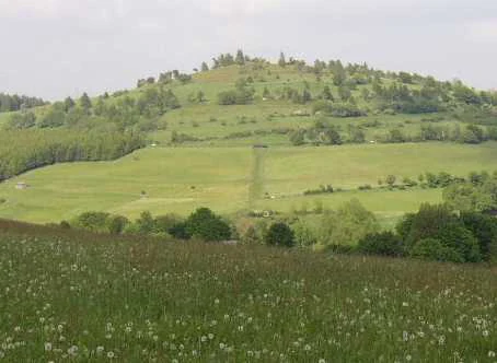
A green, rounded mountain peak rises above rolling, grassy hills with small trees and shrubs scattered across the slopes.
A view of the Osterkopf peak from the Heimberg, showcasing the mountain meadow and heath landscape of the nature reserve.

Naturschutzgebiet Osterkopf bei Usseln history and protected-area timeline

The Osterkopf bei Usseln reserve was formally designated in 1982 by the Regierungsbezirk Kassel, the regional administrative authority in northern Hesse at that time. Its establishment was driven by the area's recognised botanical importance, particularly the presence of high-altitude heath and associated plant communities that had become rare in intensively cultivated central Europe.

By the time of designation, ecologists and conservation planners had begun to view the remaining upland heaths of the Upland as relics of once more extensive open landscapes. Protective status was seen as a means to halt further loss through afforestation, agricultural improvement, or abandonment-driven succession. Designating the area as a Naturschutzgebiet under Hessian law provided the strongest available national-level protection.

A subsequent and important development in the site's history is its formal recognition as a European Habitats Directive site. The boundaries of the Naturschutzgebiet coincide exactly with those of the FFH-Gebiet Osterkopf bei Usseln, coded DE-4718-301. This alignment effectively embedded the reserve within the pan-European Natura 2000 network and ensured its continued conservation significance within an EU framework.

Although the local designation order refers broadly to "rarity, special character, and beauty" of the area, the underlying motivation highlighted in its history is the preservation of a specific type of upland vegetation that remains under pressure across central Europe.

Naturschutzgebiet Osterkopf bei Usseln landscape and geographic character

The Osterkopf bei Usseln reserve is defined by its position on the summit and upper slopes of the Osterkopf hill in the Upland highlands of northern Hesse. The terrain rises above the surrounding valleys, creating an exposed, windswept mountain-top environment that contrasts sharply with the lower-lying agricultural land of the nearby Upland villages. The summit itself is rounded rather than sharply peaked, with broad ridge crests and gentle high-elevation plateaus.

The reserve's landscape character is dominated by open ground. Mountain-top dry heath occupies much of the higher ground, while species-rich mountain meadows and mat-grass swards (Borstgrasrasen) extend along the slopes. These open habitats are separated by occasional transitions into scrub or bracken and are framed by the surrounding forested slopes typical of the wider Waldeck-Frankenberg region.

The result is a distinctive mosaic of habitat types compressed into a small area. Visitors approaching the Osterkopf from Usseln pass through forested hillside before emerging onto the open summit heath, where the landscape opens up considerably. From the summit, eastward views reach toward the Kasseler Berge, and the wider rolling upland countryside of the Diemelsee Naturpark unfolds in all directions. The combination of elevation, openness, and managed semi-natural vegetation gives the landscape a markedly northern, almost austere character for its latitude.

Naturschutzgebiet Osterkopf bei Usseln ecosystems, habitats, and plant life

Ecologically, the Osterkopf bei Usseln reserve is significant as a protected example of high-altitude heathland vegetation within the German central uplands. Although small, it preserves ecological conditions more commonly associated with the Atlantic fringe of Europe and the Boreal zone further north. This unusual character is reflected in the explicit reference in the reserve's description to an Atlantic-Boreal vegetation character (atlantisch-nordischer Vegetationscharakter).

The core of the reserve is mountain-top dry heath, a habitat dominated by low shrubs, dwarf shrubs, grasses, and herbs adapted to nutrient-poor, acidic, and often exposed conditions. Around the heath, species-rich mountain meadows contribute additional botanical diversity, with flowering plants typical of upland grassland communities. Mat-grass swards, a particularly characteristic and increasingly rare upland habitat, form another important component.

What makes the reserve ecologically distinctive is not a single dominant feature but the persistence of the entire heath-meadow mosaic in close combination. Many similar sites in central Germany have been lost to agricultural intensification, reforestation, or succession following land abandonment. The Osterkopf retains its open character because of its protected status, and it functions as a refuge for plant communities that have become fragmented elsewhere in the region.

Naturschutzgebiet Osterkopf bei Usseln wildlife and species highlights

The official justification for the nature reserve highlights botanical rather than faunal importance, so detailed wildlife information is not central to the site's record. Nevertheless, open upland habitats of the kind preserved at the Osterkopf typically support characteristic assemblages of insects, breeding birds, and small mammals adapted to dry heath and unimproved grassland.

Mountain heaths of this character are commonly used by specialist invertebrates, including butterflies, bees, and other pollinators associated with flowering-rich, nutrient-poor grassland. Birdlife typical of such open upland habitats may include meadow-breeding species, while the mosaic of heath and meadow edges provides structural diversity for small ground-nesting fauna. The reserve's connectivity with neighbouring protected heaths in the Upland and across the state border into North Rhine-Westphalia increases its functional value for species that require larger habitat networks.

Naturschutzgebiet Osterkopf bei Usseln conservation status and protection priorities

The Osterkopf bei Usseln carries strong and layered conservation significance. As a Hessian Naturschutzgebiet, it benefits from the strictest form of national nature protection available under German law, with restrictions on land use, development, and damaging activities. The reserve is also IUCN Category IV, meaning it is primarily managed for the conservation of specific habitats and species rather than for landscape-scale protection or wilderness values.

A key conservation feature is its exact overlap with the FFH-Gebiet Osterkopf bei Usseln (DE-4718-301), a site designated under the European Union Habitats Directive. This ensures that the area is treated within the Natura 2000 network, and it obligates ongoing monitoring and reporting of conservation condition at the European level. The dual status of national and EU protection has helped secure long-term stability for the site.

The reserve functions within a wider conservation landscape. It lies inside the Naturpark Diemelsee, a regional park that frames the reserve within broader sustainable land-use goals. Functionally, the Osterkopf is also linked to other highland heaths in the Upland and adjacent North Rhine-Westphalia, creating a cross-border network of similar habitats. Management priorities focus on preserving the open heath and meadow mosaic, preventing succession toward woodland, and maintaining the nutrient-poor conditions that sustain the specialised plant communities.

Naturschutzgebiet Osterkopf bei Usseln cultural meaning and human context

The Osterkopf bei Usseln reserve is situated in the Upland, a traditional highland region of northern Hesse known historically for its small villages, upland farming, and long-established patterns of mixed land use. The village of Usseln, just south of the reserve, is part of the municipality of Willingen (Upland), a community well known both for its upland character and for winter tourism.

The reserve itself reflects a broader European cultural shift in the late twentieth century, when many small upland heaths across Germany lost their traditional use as extensive grazing land and were either ploughed, fertilised, afforested, or abandoned. By formally protecting a remaining patch of this cultural-natural landscape in 1982, the reserve effectively preserves an artefact of older agricultural systems alongside the ecological communities those systems sustained.

Local conservation groups have played a notable role. The reserve features in the work of regional naturalist publications, and NABU Waldeck-Frankenberg, the local branch of Germany's largest nature conservation association, maintains a public profile for the site. This local stewardship reflects the broader cultural recognition of the Upland region as a landscape of high ecological and recreational value.

Top sights and standout views in Naturschutzgebiet Osterkopf bei Usseln

A compact Upland highland reserve whose protected status preserves both a rare habitat and a piece of regional ecological identity. Co-designation as a Hessian Naturschutzgebiet and an EU Habitats Directive site gives the Osterkopf unusually robust conservation protection for its modest size.

The reserve's defining qualities are its mountain-top heath, its mat-grass swards, and the unusually Atlantic-Boreal character of its vegetation, all retained in a small footprint directly accessible from the village of Usseln. Its position within the Naturpark Diemelsee and its ecological links to neighbouring highland heaths make it a meaningful waypoint in the broader Upland heath network.

Best time to visit Naturschutzgebiet Osterkopf bei Usseln

The Osterkopf bei Usseln is an open, high-elevation landscape in the Upland, so weather and season strongly shape the visitor experience. Late spring and summer bring the most visible botanical display, when mountain meadows around the heath reach their flowering peak and the open slopes are at their most colourful. The exposed summit can be windswept even in mild months.

Late summer and early autumn offer quieter visits as the meadows begin to dry and the heath takes on warmer tones, making the open landscape particularly easy to read from walking paths. Winter visits are possible but require preparation: snow is common at this elevation, and the open terrain offers little shelter. In all seasons, the small size of the reserve rewards a slow, short walk rather than a longer expedition, and pairing it with neighbouring heaths in the Upland is the natural way to extend the experience.

Monthly climate preview

Long term temperature and precipitation measurements across twelve monthly periods

Naturschutzgebiet Osterkopf bei Usseln Climate Normals and Annual Weather Patterns

Representative coordinate records show average temperatures ranging from subzero winter minima to warm summer maximums alongside consistent year round precipitation rates. Examining the full twelve month statistical breakdown provides deeper insight into the long term climate rhythm governing this protected landscape.
Annual mean9 °C
0 °C18 °C
Jan
Feb
Mar
Apr
May12°
Jun15°
Jul18°
Aug18°
Sep14°
Oct
Nov
Dec
Warmest month
July

18 °C

Coolest month
January

-0.2 °C

Wettest month
July

2.6 mm/day

Driest month
April

1.7 mm/day

Park location guide

Geography guide, regional context, and park location map for Naturschutzgebiet Osterkopf bei Usseln

Naturschutzgebiet Osterkopf bei Usseln park geography, regions, and map view in Germany

Understand where Naturschutzgebiet Osterkopf bei Usseln sits in Germany through a broader geographic reading of the surrounding landscape, nearby location context, and its mapped position within the national park landscape.

How Naturschutzgebiet Osterkopf bei Usseln fits into Germany

Germany is a federal republic in Western and Central Europe with a population of over 83 million across sixteen constituent states. It is Europe's largest economy by nominal GDP and a major global exporter and importer. The capital is Berlin, and the country borders Denmark, Poland, Czech Republic, Austria, Switzerland, France, Luxembourg, Belgium, and the Netherlands.

Wider geography shaping Naturschutzgebiet Osterkopf bei Usseln in Germany

Germany is located in Western and Central Europe, spanning 357,022 km². It borders Denmark to the north, Poland and the Czech Republic to the east, Austria and Switzerland to the south, and France, Luxembourg, Belgium, and the Netherlands to the west. The country has coastlines on the Baltic Sea and North Sea to the north, with the Alps located in the southern region.

Map view of Naturschutzgebiet Osterkopf bei Usseln

Use this park location map to pinpoint Naturschutzgebiet Osterkopf bei Usseln in Germany, understand its exact geographic position, and read its mapped placement within the surrounding landscape more clearly.

Pigeon | © OpenStreetMap contributors

Location context for Naturschutzgebiet Osterkopf bei Usseln

Hesse

Visualizing high-altitude heath landscapes, summit terrain, and protected habitats

Naturschutzgebiet Osterkopf bei Usseln Photos and Highland Scenery

Visual records capture the distinctive mountain-top heath, open meadows, and windswept terrain characterizing Naturschutzgebiet Osterkopf bei Usseln. Photographic documentation reveals how rare Atlantic-Boreal vegetation shapes the protected upland environment across northern Hesse.

A green, rounded mountain peak rises above rolling, grassy hills with small trees and shrubs scattered across the slopes.

A wooden bench placed on a grassy, heath-covered summit with conifers nearby and rolling hills in the distance.

Park atlas

Compare adjacent highland heaths and regional nature reserves across northern Hesse

Parks Near Naturschutzgebiet Osterkopf bei Usseln and Surrounding Protected Areas

Browse other protected areas and mountain reserves located near Naturschutzgebiet Osterkopf bei Usseln in central Germany. Expanding the regional park comparison reveals connected upland landscapes and similar botanical habitats across the wider highland terrain.
A soft watercolor painting depicting a landscape of rolling green hills, gentle slopes, and distant mountains against a plain background.
Nature reserveHessen
About 2.3 km away#1 closest

South

Naturschutzgebiet Kahle Pön bei Usseln: Protected Highland Heath and Upland Landscapes

A rare botanical nature reserve within the Hessian Upland landscape

Naturschutzgebiet Kahle Pön bei Usseln protects an open heath plateau above the Usseln valley, providing essential habitat for heath-breeding birds and rare butterflies. This nature reserve serves as an vital component of the transboundary highland heath network, demonstrating unique conservation efforts through sheep grazing and sod removal on former beech woodland soils in Waldeck-Frankenberg.

Area
0.35 km²
Established
1987
IUCN
IV
Nature reserveHochsauerlandkreis
About 3 km away#2 closest

Southeast

Naturschutzgebiet Osterntal: Protected Valley Mosaic and Regional Geography

Explore nature reserve boundaries and ecological terrain in Hochsauerlandkreis.

Naturschutzgebiet Osterntal protects a distinct valley mosaic in the eastern Sauerland, featuring rare wet grasslands and nutrient-poor meadows. This nature reserve provides essential habitat connectivity within the broader European Bird Protection Area, showcasing the region's managed pastoral landscape and varied topography.

Area
0.064 km²
Established
2003
Relief
Upland
Climate
Temperate
A pale, minimalist watercolor painting showing rolling green hills, meadows, and sparse trees against a soft, light background.
Nature reserveWaldeck-Frankenberg
About 4.4 km away#3 closest

East

Naturschutzgebiet Grotenberg bei Welleringhausen: Mapped Nature Reserve in Waldeck-Frankenberg

A preserved dry grassland landscape in the eastern Sauerland mountains.

This protected area represents a crucial remnant of silicate dry grassland in the Waldeck-Frankenberg district. Known for its diabase-rich volcanic substrate and successful habitat restoration through traditional Heidschnucken sheep grazing, the reserve offers a compact window into the upland ecology of the eastern Sauerland mountain region.

Area
0.198 km²
Established
1992
IUCN
IV
A watercolor-style digital illustration of a gentle, rolling green landscape with a winding path and distant hills on a white background.
Nature reserveWaldeck-Frankenberg
About 4.5 km away#4 closest

Southwest

Naturschutzgebiet Grebensteine bei Willingen: Protected Forest and Rock Outcrop Atlas

Ecological mapping of the Itter valley gorge forest in Waldeck-Frankenberg

This nature reserve protects a rare, near-primary gorge forest (Schluchtwald) in northern Hesse. Its steep slopes are characterized by isolated rock outcrops, boulder-rich substrates, and springs that foster high botanical diversity. The site serves as a critical example of upland forest conservation within the larger protected landscape of the Rothaargebirge foothills and the Diemelsee Nature Park.

Area
0.157 km²
Established
1985
IUCN
IV
Relief
Mountain
Nature reserveHochsauerlandkreis
About 5 km away#5 closest

South

Naturschutzgebiet Almecke: Geographic Atlas and Protected Landscape Overview

A preserved hedgerow mosaic in the Hochsauerlandkreis region.

Naturschutzgebiet Almecke is a significant nature reserve characterized by its formal inclusion in the European bird protection area network. The site offers a concentrated look at traditional cultural landscapes, specifically the interaction between steep valley topography, contour-following hedgerows, and dry upland pastures. This protected area serves as an essential case study in localized conservation geography and habitat structure within the wider Sauerland region.

Area
0.058 km²
Established
2003
Relief
Upland
Scope
Terrestrial
Nature reserveWaldeck-Frankenberg
About 5 km away#6 closest

Southwest

Naturschutzgebiet Jägers Weinberg: Geographic Profile of a Protected Upland Wetland

A mapped nature reserve in the Waldeck-Frankenberg district of northern Hesse

Naturschutzgebiet Jägers Weinberg is a protected wetland landscape in northern Hesse, Germany. This area preserves a rare combination of raised bog and birch swamp forest, functioning as a vital botanical refuge in the Waldeck-Frankenberg district. Its mapped boundaries highlight a specialized ecological site that offers clear insights into the micro-topography and natural history of the local Upland terrain.

Area
0.254 km²
Established
1979
IUCN
IV
Relief
Upland
A horizontal watercolor painting depicting a soft, pastel-colored landscape with rolling hills in the background, a line of trees in the midground, and a small winding stream or boggy area in the foreground.
Nature reserveHessen
About 5.4 km away#7 closest

Southwest

Naturschutzgebiet Alter Hagen bei Willingen: Protected Nature Reserve and Wetland Atlas

Landscape and geographic overview in the Hessen region

Naturschutzgebiet Alter Hagen bei Willingen covers a significant floodplain system in the Hessen uplands. This nature reserve serves as a critical habitat for diverse butterfly communities and relict woodland flora, centered on the headwaters of the River Itter. Its mix of swamps, bogs, and beech-dominated forest makes it a key site for understanding the geography of protected mire ecosystems in Central Germany.

Area
1.436 km²
Established
1989
IUCN
IV
Relief
Upland
Nature reserveNordrhein-Westfalen
About 7.1 km away#8 closest

West

Hoppecke-Quellbäche Nature Reserve: Protected Headwater Landscapes in Nordrhein-Westfalen

Highland spring and mountain brook habitats within the Rothaargebirge

Hoppecke-Quellbäche safeguards essential headwater habitats across the mid-slopes of the Clemensberg and the high ground leading to the Langenberg. This nature reserve, organized into three distinct parcels, maps the hydrological connections that feed the upper Hoppecke stream within the broader protected-area network of the northern Sauerland region.

Area
0.169 km²
Established
2008
IUCN
IV
Relief
Mountain

Common questions about visiting, size, designation, and location context for Naturschutzgebiet Osterkopf bei Usseln

Naturschutzgebiet Osterkopf bei Usseln FAQs for park facts, access, geography, and protected area context

Find quick answers about Naturschutzgebiet Osterkopf bei Usseln, including protected-area facts, park geography, trail and visitor context, and how the park fits into its surrounding country and regional landscape.
MoriAtlas Explorer

Continue Your Protected Areas Search Across the Global Atlas

Deepen your exploration by continuing the structured search for national parks and protected areas worldwide. Utilize the comprehensive filtering capabilities to compare different conservation landscapes and refine your understanding of global park geography. Discover more about the distribution and characteristics of protected natural areas.

Global natural geography