


Why Parque Departamental y Área Natural de Manejo Integrado Iténez stands out
The park is best known for its enormous expanse of lowland Amazonian habitat along the Iténez River and its exceptional biodiversity. It is especially recognized for the local populations of river dolphins, giant otters, and black caimans, as well as for the genetic uniqueness of the wild cacao, known locally as Beniano cacao, that grows in natural 'chocolatales' across the reserve. It is also notable as one of the largest integrated-management protected areas in the Bolivian Amazon, where conservation and traditional rural land use coexist. The combination of large-scale habitat protection with a resident human population engaged in non-industrial forest harvesting gives the park a distinctive profile among Bolivian and South American reserves.
Parque Departamental y Área Natural de Manejo Integrado Iténez history and protected-area timeline
The Iténez park was formally established on April 8, 2003, through Prefectural Resolution No. 47/03, under the administration of the Beni Department. The designation as an integrated management natural area reflected an approach that combined biodiversity conservation with the recognition of the social and economic realities of the communities already living in the region.
At the time of its creation, the broader area surrounding the modern park boundaries supported a population of roughly 3,550 inhabitants, with communities spread across 13 localities in the municipality of Magdalena and one additional settlement in the adjoining municipality of Baures. This human presence shaped the management model chosen for the reserve, allowing traditional livelihoods and subsistence agriculture to continue alongside conservation objectives.
In August 2022, the park experienced a serious environmental crisis when a series of forest fires affected more than 5,000 hectares within and near the protected area, putting local inhabitants, particularly those of Bella Vista, at direct risk. The response involved around 100 members of the Bolivian Armed Forces alongside 46 local volunteers, supported by helicopter operations with water-carrying capability provided by the Ministry of Defense. The incident underscored the vulnerability of large tropical protected areas to wildfire and highlighted the importance of coordinated local and national response in Amazonian conservation.
Parque Departamental y Área Natural de Manejo Integrado Iténez landscape and geographic character
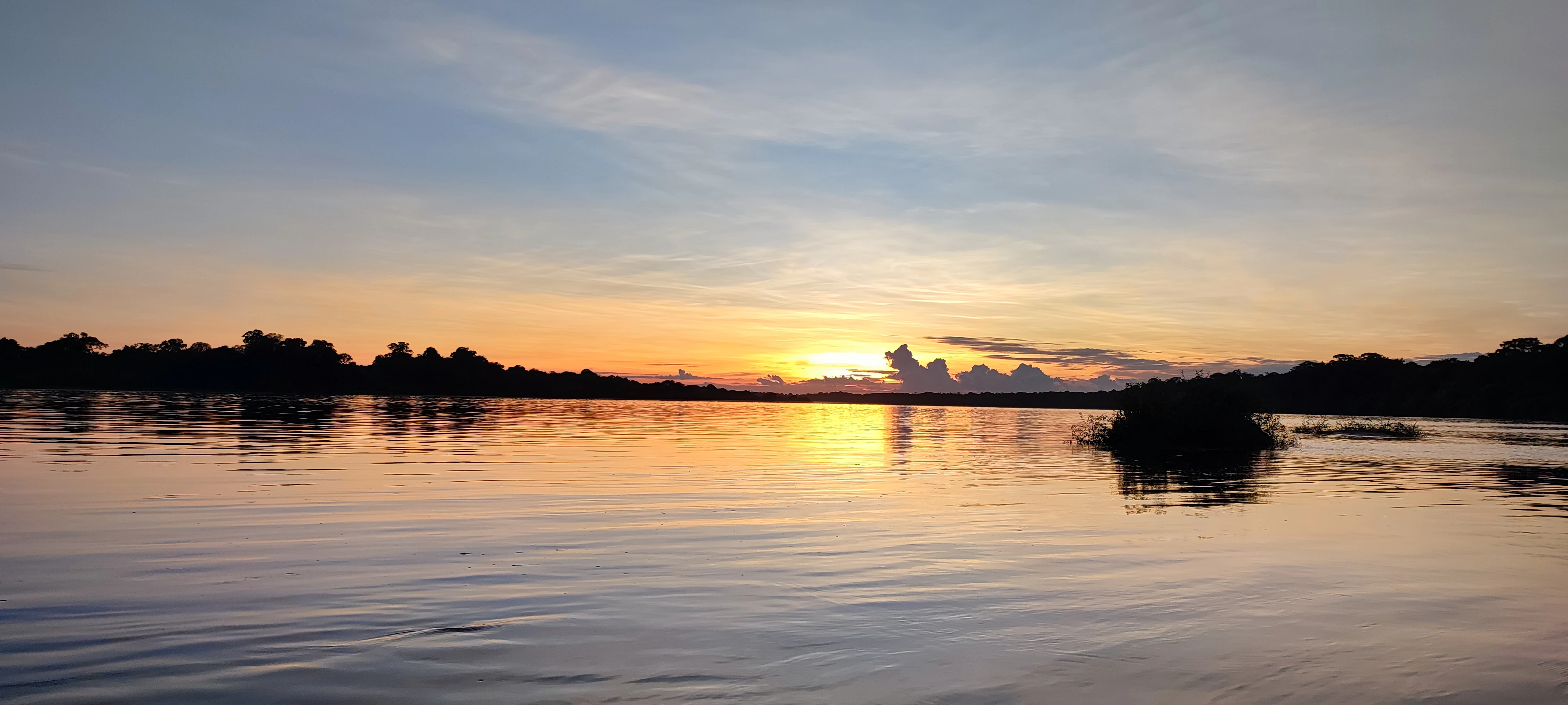
The Iténez park is defined by the vast lowland geography of the southwestern Amazon. Its terrain is dominated by extensive tracts of tropical forest interspersed with the river systems, floodplains, and wetland mosaics associated with the Iténez River basin. Elevation throughout the area is consistently low, reflecting the position of the Beni Department within the broader Amazon Depression.
Large river corridors shape much of the landscape, with the Iténez River and its tributaries creating a network of permanent and seasonal waterways. These riverine corridors, along with associated lagoons and seasonally flooded forests, give the park its characteristic alternation between dense dry-ground forest and wetter floodplain environments. The result is a largely flat but ecologically varied landscape, with little topographic relief but pronounced hydrological complexity.
The combination of unbroken forest cover, large wetland systems, and extensive river frontage creates the visual and ecological scale that defines the Iténez park. While not marked by dramatic geological features such as mountains or canyons, the area's landscapes carry considerable scenic value through their sheer extent and the contrast between river channels, flooded forest, and terra firme vegetation.
Parque Departamental y Área Natural de Manejo Integrado Iténez ecosystems, habitats, and plant life
The park harbors a rich ecological mosaic shaped by the interface between Amazonian terra firme forest, riverine habitats, and seasonally inundated floodplains. Forest cover dominates the protected area, sustaining a network of trees, understory plants, and lianas adapted to the seasonal climate of the southern Amazon. More than 490 plant species have been documented, providing a foundation for the area's exceptional biological value.
Wetland and freshwater habitats are particularly important features of the park's natural systems. The rivers and lagoons support freshwater communities of fish, aquatic mammals, and reptiles, while adjacent riparian and floodplain forests contribute additional floral and structural diversity. This ecological complexity gives the park a notable role in maintaining hydrological and ecological processes across a very large tract of the Bolivian Amazon.
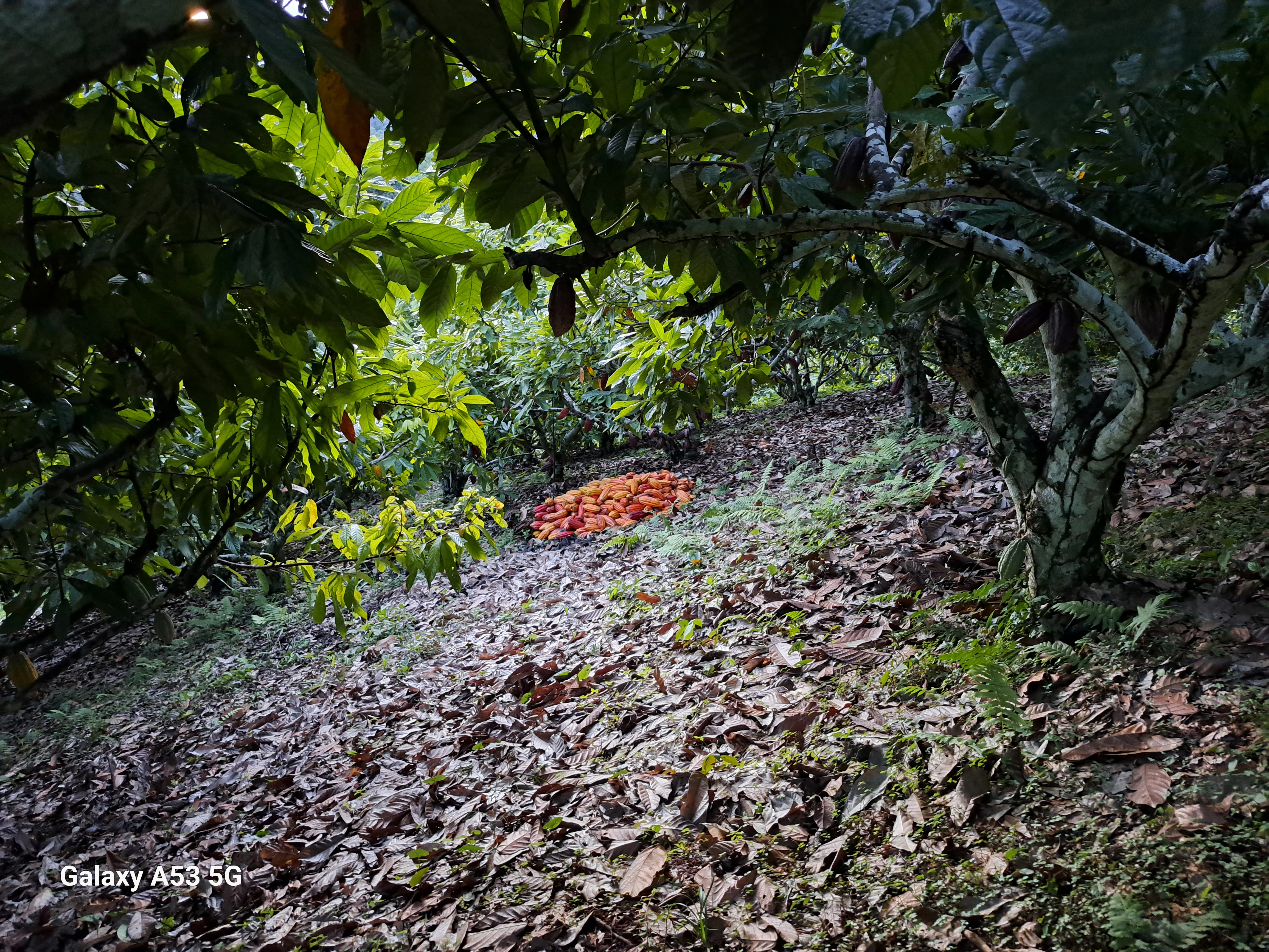
Of special ecological interest is the presence of naturally occurring wild cacao populations, locally known as chocolatales, which represent a unique genetic lineage known as Beniano cacao. These wild stands integrate plant biodiversity, traditional land use, and regional economic activity into a single ecological and cultural system, giving the park an unusual combination of biodiversity conservation and sustainable resource use.
Parque Departamental y Área Natural de Manejo Integrado Iténez wildlife and species highlights
Faunal diversity is one of the defining features of the Iténez park, with more than 714 recorded species across mammals, birds, reptiles, amphibians, and fish. The area is particularly recognized for its freshwater and aquatic wildlife, an outcome of the dominance of river and floodplain habitats across the protected landscape.
Among the most emblematic species are the river dolphins that inhabit the Iténez River and its tributaries, the giant otter, one of the rarest and most threatened mustelids in South America, and the black caiman, a large crocodilian that occupies many of the region's slow-moving rivers and lagoons. The presence of these species highlights the importance of the park for aquatic and semi-aquatic wildlife conservation in lowland Bolivia.
Beyond these flagship species, the park supports 74 mammal species, 360 bird species, 45 reptile species, and 42 amphibian species, creating one of the richest faunal inventories of any Bolivian protected area. This abundance is sustained by the park's size, habitat heterogeneity, and relatively unbroken forest cover, and it positions the reserve as an important refuge for wildlife across the southwestern Amazon.
Parque Departamental y Área Natural de Manejo Integrado Iténez conservation status and protection priorities
The Iténez park plays an important role in conserving lowland Amazonian ecosystems at a regional scale. As the third largest protected area in the Bolivian Amazon, it safeguards an extensive block of tropical forest and freshwater habitat, helping to maintain ecological connectivity and ecosystem function in a region otherwise affected by expanding human pressures.
Its integrated management category reflects a conservation model that places equal emphasis on protecting natural values and sustaining the traditional livelihoods of resident communities. By formalizing the presence of local populations and their subsistence activities, the park seeks to align biodiversity protection with long-term socio-environmental stability in a frontier region of the Amazon basin.
The 2022 forest fires demonstrated the vulnerability of large tropical reserves to environmental threats and reinforced the need for active management, rapid response capacity, and community involvement. The response, which combined military support, local volunteers, and aerial firefighting resources, illustrated how the conservation significance of the park extends beyond biodiversity alone to encompass the protection of human communities and their traditional way of life in the Amazon.
Parque Departamental y Área Natural de Manejo Integrado Iténez cultural meaning and human context
The cultural identity of the Iténez park is closely interwoven with the indigenous and farming communities that have long inhabited the Magdalena municipality and surrounding areas. At its establishment, roughly 3,550 people lived in communities distributed across the park and its immediate surroundings, with larger settlements such as Bella Vista serving as the main population centers. This long-standing human presence shapes the cultural geography of the protected area.
Traditional productive activities, including subsistence agriculture and the harvesting of cacao, Brazil nuts, and natural rubber, form the backbone of local livelihoods and connect the community to specific forest resources such as the chocolatales. These practices reflect a relationship with the landscape in which cultural identity, economic survival, and ecological knowledge are mutually reinforcing.
The presence of these communities is a defining feature of the park, distinguishing the Iténez reserve from strictly exclusionary protected areas. By integrating cultural heritage and traditional land use into its management framework, the park represents a model of conservation that recognizes the value of resident human communities as part of the Amazonian landscape.
Top sights and standout views in Parque Departamental y Área Natural de Manejo Integrado Iténez
Among the strongest highlights of the Iténez park are its sheer size as one of the largest protected areas in the Bolivian Amazon, the exceptional biodiversity across flora and fauna, and the presence of emblematic freshwater species such as river dolphins, giant otters, and black caimans.
Equally important is the unique conservation and cultural model represented by the integration of 14 indigenous and farming communities into the protected-area framework, and the global ecological importance of the wild Beniano cacao populations found in the forest. These qualities together give the park a distinctive identity that combines ecosystem-scale conservation with traditional Amazonian livelihoods.
Best time to visit Parque Departamental y Área Natural de Manejo Integrado Iténez
The Iténez region follows the climatic rhythm of the southwestern Amazon, with a pronounced wet season and a drier period that affects both accessibility and the character of the landscape. The dry months generally offer easier overland access and clearer conditions for wildlife observation along rivers and lagoons, when water levels recede and animal activity concentrates near permanent water sources.
The wet season transforms the park into a landscape of swollen rivers, flooded forests, and saturated lowlands, creating exceptional conditions for aquatic wildlife viewing. River dolphins, giant otters, and black caimans remain active year-round, but their visibility varies with seasonal hydrology. Travellers drawn to river-based exploration may find the wet season especially rewarding, while those seeking stable ground conditions and broader forest access may prefer the drier months.