

Mori Atlas logo
Protected landscapePaisaje protegido Paso Centurión y Sierra de Ríos

Mapping the ecological transition between subtropical forests, sierras, and native grasslands

Paisaje protegido Paso Centurión y Sierra de Ríos: A Detailed Map of Uruguay Borderland Landscapes

Paisaje protegido Paso Centurión y Sierra de Ríos represents a significant protected area within the Cerro Largo Department of northeastern Uruguay. This region functions as a vital transition zone where rocky sierras, quebradas, and plateaus integrate with influences from the Brazilian Mata Atlántica and Paraná subtropical forest. The geography features a complex mosaic of woody vegetation and natural grasslands, reflecting the intersection of distinct biogeographic regions.

protected landscapeSierras del EsteMata AtlânticaParaná subtropical foresttransition zonenatural grasslands
A minimalist, flat-style illustration of a river landscape with pine trees, steep valley walls, and a rising sun in the background.

Paisaje protegido Paso Centurión y Sierra de Ríos

Protected landscape

Park overview

Structured park overview, official facts, and landscape profile for Paso Centurión y Sierra de Ríos Protected Landscape

Paso Centurión y Sierra de Ríos Protected Landscape park facts, protected area profile, and essential visitor context

Review the core facts for Paso Centurión y Sierra de Ríos Protected Landscape, including designation, size, terrain, visitor scale, habitats, and operating context in one park-focused overview.

About Paso Centurión y Sierra de Ríos Protected Landscape

Paso Centurión y Sierra de Ríos Protected Landscape is a young but ecologically significant area in Uruguay's protected-area network. Created in 2019 under the category of Paisaje Protegido, or protected landscape, it was formally incorporated into Uruguay's National System of Protected Areas (SNAP) to conserve a representative example of the Sierras del Este landscapes and their associated ecological transitions.

Geographically, the area is anchored in the Cerro Largo department in northeastern Uruguay, directly along the international border with Brazil. Its position gives the park an unusual identity: while it belongs administratively to Uruguay and is shaped by Uruguayan sierras, hills, plateaus, and natural grasslands, its ecology carries strong elements from the Mata Atlântica and the Paraná subtropical forest, large biomes that dominate across the border in Brazil. This makes the park a kind of southern outpost or ecological meeting zone where these two influences overlap.

The landscape itself is varied and visually distinctive. Sierras and quebradas alternate with rolling lomadas and broad upland plateaus, creating a mosaic of habitats across the protected area. Native grasslands are not uniform pastures but highly heterogeneous plant communities, mixing winter and summer species with both annual and perennial life cycles and varied growth habits. These grassy systems coexist with traditional livestock-raising activities, which have helped preserve the area's overall naturalness and which are regarded as part of the cultural heritage embedded in the landscape.

From an ecological perspective, the protected area is recognized as a stronghold for species and vegetation patterns that are otherwise scarce or absent in Uruguay's protected-area network. It is particularly valued for harbouring flora and fauna with strong Mata Atlântica affinity, including some records that appear to be the first of their kind for the country. This unique character has made Paso Centurión a priority area for ongoing biological surveys and for understanding how southern Uruguay's natural systems connect to the larger South American subtropical forest biome.

As a protected landscape category, the area is managed not only for biodiversity conservation but also to maintain the relationship between natural environments and the cultural practices, particularly livestock ranching, that have shaped the land over time. This dual focus, on ecological values and on a working cultural landscape, is an important part of the protected area's identity within the SNAP.

Quick facts and research context for Paso Centurión y Sierra de Ríos Protected Landscape

Paso Centurión y Sierra de Ríos is a protected landscape category within Uruguay's SNAP, formally created by Decree No. 198/2019 on 8 July 2019. The area sits in northeastern Cerro Largo department, along Uruguay's border with Brazil, with the nearby town of Aceguá as a reference point. It lies within the Sierras del Este system and combines sierras, quebradas, hills, lomadas, and upland plateaus with natural grasslands and subtropical forest influences derived from the Mata Atlântica and the Paraná phytogeographic province.

Park context

Deeper park guide and search-rich context for Paso Centurión y Sierra de Ríos Protected Landscape

Paso Centurión y Sierra de Ríos Protected Landscape history, landscape, wildlife, and travel context

Explore Paso Centurión y Sierra de Ríos Protected Landscape through its history, landscape character, ecosystems, wildlife, conservation priorities, cultural context, and seasonal travel timing in a structured park guide built for atlas discovery and search intent.

Why Paso Centurión y Sierra de Ríos Protected Landscape stands out

The protected landscape is especially known for being a meeting point between Uruguayan sierras and the Atlantic Forest and Paraná subtropical forest biomes, giving it a distinctive borderland ecological character. It also stands out for hosting flora and fauna records that are unique or exceptionally rare elsewhere in Uruguay, reflecting strong Mata Atlântica influence on the Uruguayan side of the border.
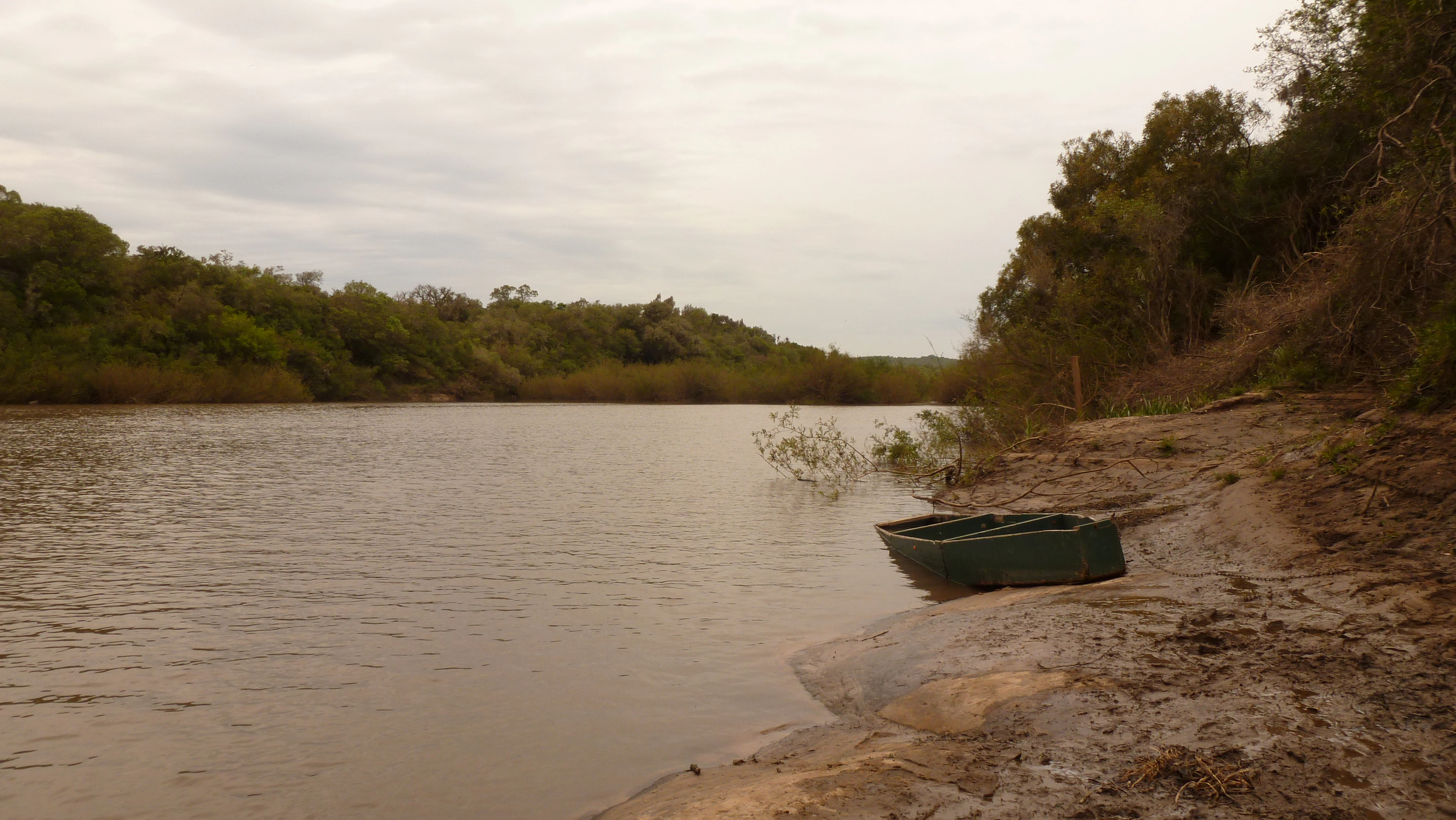
A small, dark boat sits at the edge of the Yaguaron River with a forested riverbank in the background under an overcast sky.
The Yaguaron River at Paso Centurion, showing a small boat moored along the riverbank.

Paso Centurión y Sierra de Ríos Protected Landscape history and protected-area timeline

The Paso Centurión y Sierra de Ríos Protected Landscape was formally established as part of Uruguay's National System of Protected Areas (SNAP) on 8 July 2019 through Decree No. 198/2019, under the Paisaje Protegido, or Protected Landscape, designation. The creation of the area reflects a national effort to conserve representative examples of Uruguay's Sierras del Este system and the ecological transition zones that occur along the Brazilian border.

The protected landscape builds on a long-standing tradition of livestock ranching in the region, which has shaped the grasslands and helped maintain the area's overall naturalness. Designation under the protected landscape category, rather than a strictly strict-reserve category, recognizes this combination of natural and cultural values. Since its creation, ongoing biological surveys have continued to expand records of unique species and vegetation types within the park.

Paso Centurión y Sierra de Ríos Protected Landscape landscape and geographic character

The protected landscape forms part of the Sierras del Este system in northeastern Uruguay, a region characterized by a mosaic of physical features rather than a single dominant landform. Rocky sierras and quebradas, or ravines, alternate with more rounded lomadas, raised plateaus, and undulating hill country, producing a varied relief across the protected area. These landforms create different exposures, slopes, and microclimates that support contrasting plant communities within short distances.

Because the protected area lies directly along the Uruguay-Brazil border, its landscape carries a distinctive southeastern-position character. The terrain reflects both Uruguayan sierras geology and the broader influences of the Mata Atlântica and Paraná subtropical forest regions just across the border. Natural grasslands, which are a defining feature of the area, occur in a patchwork alongside these woody habitats, often shaped by ongoing traditional livestock use.

Paso Centurión y Sierra de Ríos Protected Landscape ecosystems, habitats, and plant life

Ecologically, Paso Centurión y Sierra de Ríos is defined by the meeting of major South American biomes. The protected area falls within the transition zone where Uruguayan sierras ecosystems meet the Mata Atlântica and the Paraná phytogeographic province. This transitional character gives the park unusual ecological richness and a vegetation profile that is more diverse than many other protected areas in the country.

Natural vegetation in the area includes subtropical forest elements with strong Atlantic Forest affinity, alongside native grasslands that are notable for their heterogeneity. The grasslands combine winter and summer species, annual and perennial plants, and species with varying growth habits, contributing to high ecological resilience, particularly in the face of climate variability. Woody plant communities occupy the sierras, quebradas, and plateaus, integrating with the open grassland systems to form a complex vegetation mosaic.

The protected area is also important as a refuge for species with distributions that are primarily centred in Brazilian subtropical forest biomes but reach their southern limits in this part of Uruguay. Botanical surveys have steadily expanded the list of first-time Uruguay records for various plant species within the park, reinforcing its importance as a transitional refuge.

Paso Centurión y Sierra de Ríos Protected Landscape wildlife and species highlights

The protected area has been documented as hosting at least 18 mammal species, and several of these records are considered notable or unique within Uruguay's system of protected areas. Among the most remarkable are records of the paca, the cuica de agua (a water opossum), the yapok, the jaguarundi (Puma yagouaroundi), and the aguara guazú or maned wolf (Chrysocyon brachyurus), the last of which represents a particularly significant occurrence in Uruguay.

Birdlife in the area also carries strong Mata Atlântica and Paraná forest affinity. The Chiripepé cabeza verde (a green-headed araçari-type bird) and the Yacutoro (Pyroderus scutatus) are recorded here as unique or especially significant occurrences for Uruguay, reflecting the area's role as a southern extension of Atlantic Forest avifauna. Combined with the area's position along an international border, these records mark Paso Centurión as an important step in understanding the wildlife connections between Uruguay and southern Brazil.

Paso Centurión y Sierra de Ríos Protected Landscape conservation status and protection priorities

Paso Centurión y Sierra de Ríos is significant from a conservation perspective because it conserves a landscape that sits at the southern edge of two major South American biomes, the Mata Atlântica and the Paraná subtropical forest. Its inclusion in Uruguay's SNAP under Decree No. 198/2019 in 2019 reflects the country's recognition of the area's importance for representing transitional ecosystems and for protecting biota that are otherwise marginal or absent from Uruguay's protected-area system.

The protected landscape category chosen for the area acknowledges both ecological and cultural values. The natural heterogeneity of its grasslands confers notable environmental, economic, and social sustainability, as well as resilience to climate change, while the long coexistence of livestock-raising activities with natural vegetation has helped maintain overall naturalness. This combination of natural and cultural values gives the protected area a distinctive role in Uruguay's broader conservation strategy, emphasizing the maintenance of working landscapes alongside biodiversity protection.

Paso Centurión y Sierra de Ríos Protected Landscape cultural meaning and human context

The cultural dimension of the protected landscape is closely tied to traditional livestock ranching, which has historically shaped the natural grasslands and helped preserve their heterogeneity. Grazing systems within the park are regarded as part of the local cultural heritage, complementing the area's natural values and reinforcing its protected landscape, rather than strict-reserve, designation.

Top sights and standout views in Paso Centurión y Sierra de Ríos Protected Landscape

Paso Centurión's standout features include its position as a transitional refuge at the southern edge of the Mata Atlântica and Paraná subtropical forest, the heterogeneity of its natural grasslands and woody vegetation mosaic, and its record as a unique site within Uruguay for several mammal and bird species with Atlantic Forest affinities. The combination of sierras, quebradas, plateaus, and traditional ranching landscapes gives the area a strong and distinctive identity within Uruguay's national protected-area system.

Best time to visit Paso Centurión y Sierra de Ríos Protected Landscape

As an evergreen reference, Paso Centurión is best experienced when its natural grasslands and subtropical vegetation are at their most expressive. Late spring through early autumn in the Southern Hemisphere generally brings warmer conditions and more active foliage growth, while cooler months can highlight the structural character of the grasslands and the visibility of wildlife signs in more open terrain. Seasonal conditions can also affect the experience of the rolling sierras and quebradas, which feel different under wetter versus drier conditions. Visitors interested in birdlife and the area's Atlantic Forest species may find periods when both native grasslands and forest vegetation are active, generally outside the deepest winter, most rewarding.

Park location guide

Geography guide, regional context, and park location map for Paso Centurión y Sierra de Ríos Protected Landscape

Paso Centurión y Sierra de Ríos Protected Landscape park geography, regions, and map view in Uruguay

Understand where Paso Centurión y Sierra de Ríos Protected Landscape sits in Uruguay through a broader geographic reading of the surrounding landscape, nearby location context, and its mapped position within the national park landscape.

How Paso Centurión y Sierra de Ríos Protected Landscape fits into Uruguay

Uruguay is a unitary presidential republic located in southeastern South America. It covers approximately 176,215 km² and has a population of nearly 3.5 million people. The capital and largest city is Montevideo, where roughly 2 million people live in the metropolitan area. Uruguay gained independence between 1825 and 1828 following territorial disputes involving Portugal, Spain, Brazil, and the United Provinces of the Río de la Plata.

Wider geography shaping Paso Centurión y Sierra de Ríos Protected Landscape in Uruguay

Uruguay is situated in the southeastern part of South America, bordering Argentina to its west and southwest, Brazil to its north and northeast, the Río de la Plata estuary to the south, and the Atlantic Ocean to the southeast. The terrain consists primarily of rolling plains and low hills, with the highest point being Cerro Catedral at approximately 514 meters. The country has several rivers including the Uruguay River, Paraná River, and Negro River.

Location context for Paso Centurión y Sierra de Ríos Protected Landscape

Cerro Largo Department

Visual reference for regional habitats, rocky terrain, and borderland scenery

Paisaje protegido Paso Centurión y Sierra de Ríos Photos and Landscapes

Protected area photography reveals the complex mosaic of rocky sierras, wooded quebradas, and open grasslands that define this borderland refuge. Visual documentation helps researchers and visitors analyze native vegetation patterns, subtropical forest transitions, and unique regional topography.

A small, dark boat sits at the edge of the Yaguaron River with a forested riverbank in the background under an overcast sky.

Common questions about visiting, size, designation, and location context for Paso Centurión y Sierra de Ríos Protected Landscape

Paso Centurión y Sierra de Ríos Protected Landscape FAQs for park facts, access, geography, and protected area context

Find quick answers about Paso Centurión y Sierra de Ríos Protected Landscape, including protected-area facts, park geography, trail and visitor context, and how the park fits into its surrounding country and regional landscape.
MoriAtlas Explorer

Continue Your Protected Areas Search Across the Global Atlas

Deepen your exploration by continuing the structured search for national parks and protected areas worldwide. Utilize the comprehensive filtering capabilities to compare different conservation landscapes and refine your understanding of global park geography. Discover more about the distribution and characteristics of protected natural areas.

Global natural geography