
Mori Atlas logo
Nature reservePfälzerwoog

A quiet ecological refugium within the sandstone-forested hills of the Wasgau border region.

Pfälzerwoog Nature Reserve, Mapping the Protected Wetland Landscapes of the Southern Palatinate Forest

(Naturschutzgebiet Pfälzerwoog)

Pfälzerwoog serves as a protected nature reserve in the Landkreis Südwestpfalz, offering a significant look at transitional bog and shoreline habitats within the Wasgau section of the Palatinate Forest. The protected area features a mosaic of open water, marsh, and wet-ground vegetation, contrasting with the surrounding dry sandstone slopes. This atlas entry provides a focus on the site's hydrologic character, its regional geographic setting near the border with France, and the protected mosaic that defines its ecological boundaries.

nature reserveNaturschutzgebietlakewetlandbog habitatflat bog
A stylized flat-design illustration of a tranquil lake with water lilies in the foreground, framed by trees on both sides, leading to a distant waterfall flanked by mountains under a soft sun.

Pfälzerwoog

Nature reserve

Park overview

Structured park overview, official facts, and landscape profile for Pfälzerwoog

Pfälzerwoog park facts, protected area profile, and essential visitor context

Review the core facts for Pfälzerwoog, including designation, size, terrain, visitor scale, habitats, and operating context in one park-focused overview.

About Pfälzerwoog

Pfälzerwoog is a small protected lake and surrounding wetland complex located in the southern Palatinate Forest region of Germany. It sits in the Landkreis Südwestpfalz, in the state of Rhineland-Palatinate, in the rolling and deeply wooded hill country known as the Wasgau. This part of Germany lies close to the French border, and the protected area occupies a forested corridor between the villages of Fischbach bei Dahn and Ludwigswinkel, two small Palatinate communities that embody the rural, forested character of this region.

The nature reserve designated as Pfälzerwoog was formally placed under protection in 1979. Its legal designation as a Naturschutzgebiet reflects the German system of statutory nature protection, which is reserved for areas of particular ecological value. The reserve covers roughly eleven hectares. Although the lake at its heart gives the area its name, the protected zone extends beyond the shoreline to incorporate the ecological gradients around it, including wet meadows, sedge stands, and the gradual transitions from open water to land.

Ecologically, the defining character of Pfälzerwoog is its hydrology. The site is best understood as a flat-bog and transitional-bog landscape: a formerly or still waterlogged system where groundwater chemistry, soil saturation, and gradual infilling by vegetation together create a habitat quite unlike the surrounding dry forests on sandstone. These flatter mire habitats are scarce in the predominantly well-drained Wasgau landscape, which makes Pfälzerwoog disproportionately valuable at regional scale.

The reserve is embedded in a broader recreational landscape. Several themed long-distance hiking routes run along its northern and eastern shores, including the Felsenland Sagenweg, the Wasgau-Seen-Tour, and the long green-marked Saar-Rhein main hiking trail that links Zweibrücken with the Rhine. The nearby Landesstraße 478 provides regional road access, while the proximity of the Franco-German border gives the surrounding landscape a distinctive cross-border cultural flavor. Pfälzerwoog is therefore both a seriously protected ecological site and a small, contemplative stop along hiking and discovery routes through the southern Palatinate.

Quick facts and research context for Pfälzerwoog

Pfälzerwoog is a lake and nature reserve in the Landkreis Südwestpfalz in Rhineland-Palatinate, Germany. The protected area covers about 11.32 hectares and was placed under nature protection in 1979.

It lies in the Wasgau, the forested hill country at the southern end of the Palatinate Forest, close to the state border with France and near the local communities of Fischbach bei Dahn and Ludwigswinkel. The reserve is recognized in the World Database on Protected Areas under the WDPA ID 82322.

Protection and recognition

Terrestrial protected area records and international recognition sources

Pfälzerwoog Protection Status and Documented Conservation Scope

Pfälzerwoog maintains a documented terrestrial protection status within global conservation registries. Official records detail the management framework, territorial scope, and associated designation listings for public review.

Protection details

Protection scope
Terrestrial
Transboundary protection
No
WDPA ID
82322
Park context

Deeper park guide and search-rich context for Pfälzerwoog

Pfälzerwoog history, landscape, wildlife, and travel context

Explore Pfälzerwoog through its history, landscape character, ecosystems, wildlife, conservation priorities, cultural context, and seasonal travel timing in a structured park guide built for atlas discovery and search intent.

Why Pfälzerwoog stands out

Pfälzerwoog is best known for its flat-bog and transitional-bog habitat complex, combined with open water and gently transitioning shoreline zones that harbor rare plant communities and animal species. Rather than being a dramatic scenic landmark, it is valued as a quiet wetland refugium within the matrix of the Wasgau forest, with its ecological importance grounded primarily in its moor-like hydrology and the biodiversity tied to those waterlogged conditions.
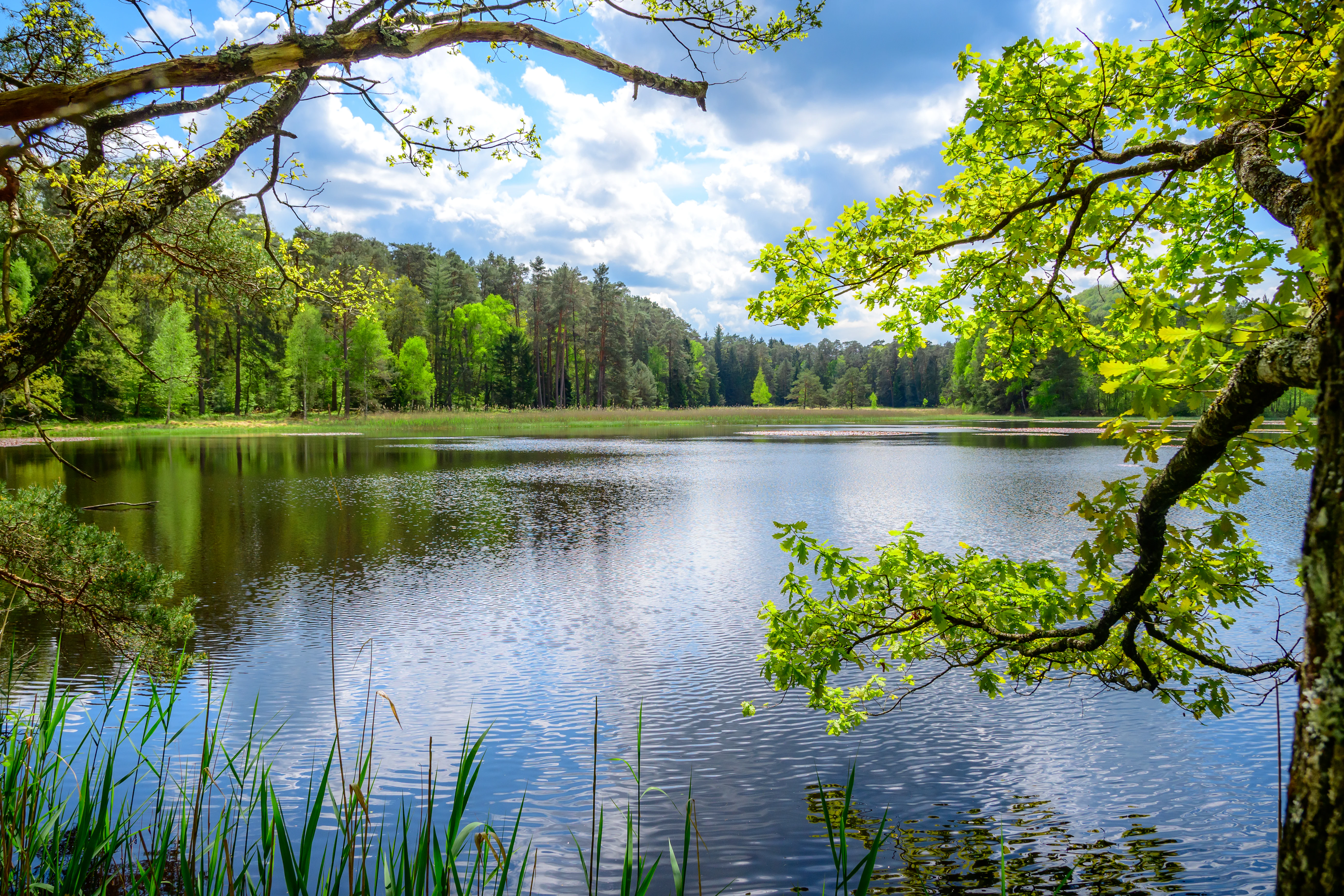
A serene lake view at Pfälzerwoog nature reserve with overhanging tree branches in the foreground, calm dark water reflecting the sky, and a dense mixed forest in the background.
The Pfälzerwoog lake surrounded by lush green forest in the nature reserve.

Pfälzerwoog history and protected-area timeline

Pfälzerwoog entered the formal German nature-conservation system in 1979, when the area was officially designated as a Naturschutzgebiet by the then-Landkreis Pirmasens, as documented in the conservation ordinance of December 11, 1979. This placement under legal protection reflected an understanding of the site as a regionally uncommon example of flat-bog and transitional-bog habitat within the broader Wasgau forest landscape.

The site's recognition was not driven by scenic drama but by its ecological role. The ordinance articulates the protection purpose as the preservation of the flat-bog to transitional-bog character, the open-water and shoreline zones, and their function as habitats for rare plant communities and animal species of scientific interest. By inscribing the area in Germany's protected-area network and giving it a WDPA record (ID 82322), the designation connected the site to international frameworks for tracking protected areas worldwide. Since 1979, the reserve has continued to function as a small, dedicated island of mire-like wetland within a much larger forested region.

Pfälzerwoog landscape and geographic character

The Pfälzerwoog reserve lies in a softly undulating section of the Wasgau, the southern extension of the Palatinate Forest defined by its forested sandstone hills, deeply incised valleys, and frequent rock outcrops. Within this broader upland setting, the protected area represents a contrasting low-lying basin where water collects rather than drains rapidly.

The lake itself is modest in size and is surrounded by wet ground that shifts gradually from open water through shallow-water and shoreline zones to denser vegetation. These transitions are central to the site's landscape character, producing a mosaic of pond, marsh, and mire-like edges rather than a single clear waterbody rimmed by dry forest.

The reserve's wider environment is shaped by the Wasgau's typical sandstone topography. Forest covers the surrounding slopes, while the lower elevations near the lake carry moisture-tolerant vegetation that thrives where groundwater emerges. The Franco-German border lies only a few kilometers to the south, and the nearby communities of Fischbach bei Dahn and Ludwigswinkel give the wider countryside a quiet, sparsely populated character.

Pfälzerwoog ecosystems, habitats, and plant life

Pfälzerwoog's ecological identity is dominated by its standing water and the bog-like habitats around it. The site's defining ecological features are its flat-bog (Flachmoor) and transitional-bog (Zwischenmoor) character, which together support a gradient of wet habitats from open water and floating vegetation through sedge- and reed-dominated margins to wet meadows and shrubby edges.

These conditions are regionally uncommon within the Wasgau, where sandstone geology and well-drained slopes favor dry forests. The reservoir of groundwater that feeds the Woog creates a small but pronounced contrast: a soft, waterlogged substrate supporting moisture-loving plants in the middle of an otherwise drier forest matrix. The protected shoreline and water-to-land transition zones (Verlandungszonen) are highlighted in the protection ordinance as the specific ecological structures worth safeguarding.

By design, the reserve aims to maintain the slow natural processes by which open water gradually fills with vegetation over time, producing species-rich, layered habitats. This makes the area ecologically interesting far beyond its size, acting as a refugium for wetland-dependent flora and fauna in a landscape that otherwise offers few comparable conditions.

Pfälzerwoog wildlife and species highlights

Because the Pfälzerwoog reserve is small and ecologically focused on wetland habitats, its wildlife significance lies less in charismatic large mammals and more in the diversity of species associated with bog and shoreline environments. The protection ordinance explicitly identifies the water and shoreline zones as habitats for rare animal species, framing the site as a refuge for fauna tied to wet conditions.

Such conditions typically support communities of aquatic invertebrates, amphibians, and wetland-associated insects, as well as birdlife that uses open water and the surrounding marsh-like edges. The reserve's location within the larger forested Wasgau, where woodland habitats dominate, makes its small wetland island especially valuable for any animal groups that depend on standing water or wet meadows.

Specific species coverage in the source material is limited, so the reserve's wildlife value is best summarized as a small but ecologically important wetland refugium set against an extensive dry-forest backdrop.

Pfälzerwoog conservation status and protection priorities

Pfälzerwoog's conservation significance derives above all from its legal designation as a Naturschutzgebiet since 1979 and from the specific ecological function it serves in the Wasgau landscape. The formal purpose of protection is to preserve the flat-bog to transitional-bog character of the area, along with its open water and shoreline zones, as habitats for rare plant species and plant communities and rare animal species of scientific interest.

In regional terms, the reserve fills an important niche. The Wasgau's sandstone geology generally produces well-drained, drought-tolerant forest, which means true mire habitats are scarce. By protecting a small area where groundwater emerges and accumulates, the site safeguards a type of habitat that the surrounding landscape cannot easily recreate if lost.

The reserve is recorded in the international World Database on Protected Areas under the identifier 82322, which signals its integration into global tracking of formally protected sites. The original 1979 protection ordinance remains the legal foundation for the area's management, and the continued emphasis on scientific and ecological value rather than purely scenic appreciation underscores its role as a long-term conservation site rather than a high-traffic recreational destination.

Pfälzerwoog cultural meaning and human context

Pfälzerwoog is not primarily a cultural-heritage site, but it sits in a landscape with strong regional identity. The Wasgau, where the reserve is located, is a culturally distinct subregion of the Palatinate Forest known for its sandstone formations, legend-rich hiking trails, and cross-border heritage with neighboring Alsace.

The nearby communities of Fischbach bei Dahn and Ludwigswinkel represent the small-village character typical of this part of the Palatinate, with traditional settlement patterns nestled in forested valleys. The area's proximity to the French border, only a few kilometers to the south, adds a transnational cultural dimension, and hikers following routes such as the Felsenland Sagenweg encounter a landscape long shaped by storytelling and walking traditions.

Top sights and standout views in Pfälzerwoog

Pfälzerwoog's standout qualities are its compact concentration of bog and shoreline habitat, its long-standing legal protection since 1979, and its position within the Wasgau, where it offers a striking ecological contrast to the surrounding dry sandstone forests. The reserve's accessibility via established themed hiking routes, including the Felsenland Sagenweg and the Wasgau-Seen-Tour, also makes it a natural pausing point for travelers exploring the southern Palatinate on foot.

What most distinguishes the site is the combination of rarity and modesty: a small area, but one that protects a habitat type that is regionally uncommon and ecologically rich.

Best time to visit Pfälzerwoog

Pfälzerwoog's character is shaped by its wetland hydrology, so the cooler and wetter months of late spring through early autumn are typically when the surrounding vegetation is most lush and the contrast between water, shore, and surrounding forest is most visible. Late spring and early summer tend to favor the growth of wetland plants and visibility of birds and insects around the Woog, while autumn brings softer light through the Wasgau forest and quieter hiking conditions.

Winter visits are also possible because the area is accessible year-round along established trails, but the ecological contrasts are more subtle when vegetation is dormant. Visitors should generally expect the gentle weather conditions typical of the Palatinate Forest rather than alpine extremes.

Monthly climate preview

Long-term representative monthly temperature and precipitation rhythm for Pfälzerwoog

Pfälzerwoog Climate Normals and Measured Annual Temperature Patterns

Historical NASA Power records track twelve-month temperature variations and daily precipitation rates measured at a representative point within Pfälzerwoog. Detailed monthly climate normals provide a complete record of long-term temperature ranges and precipitation metrics across the protected area.
Annual mean10 °C
0 °C20 °C
Jan
Feb
Mar
Apr
May14°
Jun17°
Jul20°
Aug19°
Sep15°
Oct10°
Nov
Dec
Warmest month
July

19.6 °C

Coolest month
January

0.4 °C

Wettest month
December

2.4 mm/day

Driest month
April

1.5 mm/day

Park location guide

Geography guide, regional context, and park location map for Pfälzerwoog

Pfälzerwoog park geography, regions, and map view in Germany

Understand where Pfälzerwoog sits in Germany through a broader geographic reading of the surrounding landscape, nearby location context, and its mapped position within the national park landscape.

How Pfälzerwoog fits into Germany

Germany is a federal republic in Western and Central Europe with a population of over 83 million across sixteen constituent states. It is Europe's largest economy by nominal GDP and a major global exporter and importer. The capital is Berlin, and the country borders Denmark, Poland, Czech Republic, Austria, Switzerland, France, Luxembourg, Belgium, and the Netherlands.

Wider geography shaping Pfälzerwoog in Germany

Germany is located in Western and Central Europe, spanning 357,022 km². It borders Denmark to the north, Poland and the Czech Republic to the east, Austria and Switzerland to the south, and France, Luxembourg, Belgium, and the Netherlands to the west. The country has coastlines on the Baltic Sea and North Sea to the north, with the Alps located in the southern region.

Map view of Pfälzerwoog

Use this park location map to pinpoint Pfälzerwoog in Germany, understand its exact geographic position, and read its mapped placement within the surrounding landscape more clearly.

Pigeon | © OpenStreetMap contributors

Location context for Pfälzerwoog

Rheinland-Pfalz

Visualizing the wetland habitats and forest edge terrain of the Wasgau region

Pfälzerwoog Landscape Photos and Protected Area Scenery

Visual records capture the distinctive wetland habitats, transitional bogs, and open water zones defining the protected reserve. Photographic documentation reveals the subtle lowland topography and forested sandstone surroundings typical of the southern Palatinate landscape.

A serene lake view at Pfälzerwoog nature reserve with overhanging tree branches in the foreground, calm dark water reflecting the sky, and a dense mixed forest in the background.

Park atlas

Discover adjacent nature reserves and regional forest habitats across the Wasgau

Explore Parks Near Pfälzerwoog and Surrounding Protected Landscapes

Browsing other protected areas near Pfälzerwoog reveals the broader ecological diversity of the southern Palatinate forest region. Comparing these adjacent wetland reserves and wooded valleys provides essential context for regional conservation geography.
Nature reserveRheinland-Pfalz
About 2 km away#1 closest

Northwest

Faunertal Nature Reserve and Palatinate Forest Wetland Mapping

A protected aquatic mosaic in southwestern Germany

Faunertal represents a specialized nature reserve in Rheinland-Palatinate characterized by its chain of abandoned fish ponds along the Dielbach. The site provides a clear case study in landscape transformation, where historic ponds now support diverse sedge mires, reed beds, and complex wetland ecosystems. This area serves as a critical focus for amphibian conservation and habitat connectivity within the broader forest geography of the Palatinate region.

Area
0.253 km²
Established
1983
Nature reserveRheinland-Pfalz
About 2.8 km away#2 closest

North

Wolfsägertal Nature Reserve: Mapped Wetlands and Sandstone Valley Geography

Protected aquatic ecosystems in the Wasgau, Rheinland-Pfalz

Discover the precise geographic footprint and ecological characteristics of Wolfsägertal. This nature reserve, located within the forested sandstone terrain of the Wasgau, provides a concentrated study of stream-side wetland habitats, including the Nollenkopf impoundment and associated fen meadows, all mapped and structured for clear regional context.

Area
0.222 km²
Established
1983
Nature reserveRheinland-Pfalz
About 3.6 km away#3 closest

West

Rohrweiher-Rösselsweiher Nature Reserve: Geography and Protected Area Mapping

Wetland and bog landscapes in the Rheinland-Pfalz region

Rohrweiher-Rösselsweiher is a distinctive nature reserve covering 40 hectares of complex wetland, bog, and forest edge habitats. Defined by the convergence of two forest streams, the area functions as a critical component of the regional ecology within the Palatinate Forest. This entry provides mapped insights into the hydrological features and protected land boundaries that define this vital German nature preserve.

Area
0.405 km²
Established
1979
Scope
Terrestrial
Water
Major water bodies
Nature reserveRheinland-Pfalz
About 3.7 km away#4 closest

East

Königsbruch Nature Reserve: Geographic Map and Protected Landscape Overview

Riparian ecosystems and stream networks in Rheinland-Pfalz

Königsbruch represents a vital conservation landscape in the southern Palatinate Forest, characterized by its damp woodland and the convergence of the Saarbach stream system. Our detailed geographic mapping reveals the protected valley corridors of this nature reserve, providing a clear view of its terrain, hydrological features, and boundary context within the region of Rheinland-Pfalz.

Area
1.226 km²
Established
1996
Nature reserveRhineland-Palatinate
About 6.3 km away#5 closest

East

Brauntal Nature Reserve: Protected Wetland Landscapes and Geography in Southern Palatinate

Mapped protected areas in Rhineland-Palatinate, Germany

Brauntal serves as an important nature reserve centered on a dystrophic pond and its surrounding silting zones. The site acts as a critical protected habitat within the Südwestpfalz region, offering insights into wetland ecology, stream headwaters, and hilly transition zones near the French border.

Area
0.71 km²
Established
1984
Nature reserveRheinland-Pfalz
About 7.3 km away#6 closest

East

Zeppelinhalde Nature Reserve: A Protected Juniper Hillside in the Southern Palatinate Landscape

Mapped protected habitats in the Rheinland-Pfalz region

Zeppelinhalde is a protected nature reserve in the Südwestpfalz, characterized by its rare juniper-dominated dry grassland habitat on the eastern slopes of the Kuhnenkopf. This area serves as a vital ecological link within the cross-border Palatinate Forest landscape, contrasting open, sun-exposed terrain with surrounding woodland ridges near the French border.

Established
1942
Nature reserveRhineland-Palatinate
About 8.2 km away#7 closest

North

Moosbachtal Nature Reserve: Protected Valley Geography and Ecosystem Map in Rhineland-Palatinate

A historic pond and stream mosaic in the southern Palatinate

Moosbachtal stands as a significant protected nature reserve in Rhineland-Palatinate, encompassing a unique 111-hectare mix of sandy slopes, stream-fed meadows, and historic impoundment ponds. This mapped habitat mosaic illustrates the complex successional stages of southern Palatinate forest valleys, offering clear insight into the regional conservation landscape and the connectivity between riparian systems and forested ridges.

Area
1.11 km²
Established
1984
IUCN
IV
Relief
Upland
Nature reserveRheinland-Pfalz
About 8.3 km away#8 closest

Northwest

Wolfslöcher Nature Reserve: Protected Terrain and Regional Geography in Rheinland-Pfalz

Specialized bog and rock habitat analysis within the Palatinate Forest region.

Focusing on its distinctive geological and hydrological profile, this atlas record details the ecological importance of the Wolfslöcher protected area. The site is a concentrated refuge for threatened plant species, featuring a rare combination of alder carr, narrow valley bogs, and spring-loaded sandstone niches that define the character of the southern Palatinate landscape.

Area
0.9 km²
Established
1983

Common questions about visiting, size, designation, and location context for Pfälzerwoog

Pfälzerwoog FAQs for park facts, access, geography, and protected area context

Find quick answers about Pfälzerwoog, including protected-area facts, park geography, trail and visitor context, and how the park fits into its surrounding country and regional landscape.
MoriAtlas Explorer

Continue Your Protected Areas Search Across the Global Atlas

Deepen your exploration by continuing the structured search for national parks and protected areas worldwide. Utilize the comprehensive filtering capabilities to compare different conservation landscapes and refine your understanding of global park geography. Discover more about the distribution and characteristics of protected natural areas.

Global natural geography