

Mori Atlas logo
Nature reservePiccaninny Plains Sanctuary

Tracing the tropical savanna and seasonal river corridors of a vital Queensland wildlife reserve.

Piccaninny Plains Sanctuary: Exploring Protected Landscapes and Cape York Geography

(Piccaninny Plains Wildlife Sanctuary)

Piccaninny Plains Sanctuary stands as one of the most extensive private conservation areas in the interior of the Cape York Peninsula. This vast nature reserve serves as a critical habitat corridor within Far North Queensland, connecting diverse tropical ecosystems including lush gallery rainforests, expansive grasslands, and dynamic seasonal floodplains. The property is defined by the hydrologic pulse of the Archer and Wenlock Rivers, which shape the terrain through intense monsoonal cycles and establish a continuous, unbroken landscape that supports tropical fauna across the northern Australian interior.

Cape York Peninsulatropical savannatropical grasslandsgallery rainforestwetlandsfloodplains

Piccaninny Plains Sanctuary

Nature reserve

Park overview

Structured park overview, official facts, and landscape profile for Piccaninny Plains Sanctuary

Piccaninny Plains Sanctuary park facts, protected area profile, and essential visitor context

Review the core facts for Piccaninny Plains Sanctuary, including designation, size, terrain, visitor scale, habitats, and operating context in one park-focused overview.

About Piccaninny Plains Sanctuary

Piccaninny Plains Sanctuary represents a landmark effort in private conservation within one of Australia's last great tropical wilderness regions, the Cape York Peninsula. Stretching across approximately 1,700 square kilometers in the interior of Far North Queensland, the sanctuary lies at the heart of the peninsula, surrounded by national park, Aboriginal land, and other conservation holdings. This strategic location gives the property an importance well beyond its own boundaries, as it functions as a bridging landscape between the wetter tropical forests of the east coast and the drier savanna woodlands that characterise the western side of Cape York.

The land itself is ecologically diverse, capturing a wide range of tropical habitats that are otherwise fragmented across the region. Gallery rainforests line the watercourses, while broad tropical grasslands dominate the uplands and plains, interspersed with wetlands and floodplains that pulse with water during the monsoon months. The Archer and Wenlock Rivers, both of which flow through the property, shape these habitats and feed the floodplain systems that support much of the reserve's seasonal productivity. The tropical monsoonal climate, with roughly 1,600 millimeters of rainfall concentrated largely between December and April, drives a strongly seasonal pattern of growth, flooding, and wildlife abundance.

Piccaninny Plains was historically operated as a cattle station, and its transition from grazing land to a dedicated sanctuary is a defining chapter in its modern identity. The property was purchased in 2008 and is now owned jointly by The Tony and Lisette Lewis Foundation and the Australian Wildlife Conservancy. The Australian Wildlife Conservancy manages the land as part of its broader network of sanctuaries, applying fire management, invasive species control, and ecological monitoring at a landscape scale. Within this framework, the reserve serves both as a refuge for native wildlife and as a platform for research and conservation outcomes in one of Australia's most intact tropical regions.

The sanctuary's significance is amplified by its neighbours. Oyala Thumotang National Park extends along portions of its boundary, while surrounding Aboriginal land adds further continuity to a vast, connected block of natural landscape. Together these areas form one of the largest largely intact tropical savanna systems in the country. Piccaninny Plains contributes crucially to this network by anchoring a habitat corridor that links the peninsula's two coasts, allowing wildlife to move across an enormous and largely undisturbed interior. Its combination of ecological richness, strategic geography, and professional conservation management makes it a central piece of the Cape York conservation landscape.

Quick facts and research context for Piccaninny Plains Sanctuary

Piccaninny Plains Sanctuary is a private nature reserve of about 1,700 square kilometers situated on the Cape York Peninsula in Far North Queensland, Australia. It is owned jointly by The Tony and Lisette Lewis Foundation and the Australian Wildlife Conservancy, and was acquired in 2008 after functioning for many decades as a cattle station.

The property lies adjacent to Oyala Thumotang National Park and Aboriginal-held land, creating a continuous belt of wilderness in the interior of the peninsula. It protects tropical grasslands, gallery rainforests, wetlands, and floodplain habitats, with the Archer and Wenlock Rivers running through it. Annual rainfall averages about 1,600 millimeters under a tropical monsoonal climate.

Protection and recognition

Terrestrial protected area framework and designation records

Piccaninny Plains Sanctuary Protection Status and Conservation Data

Documented protection status and territorial management scope define the conservation framework governing Piccaninny Plains Sanctuary. Official records outline terrestrial protected area metrics and international recognition standards across the landscape.

Protection details

Protection scope
Terrestrial
Transboundary protection
No
Park context

Deeper park guide and search-rich context for Piccaninny Plains Sanctuary

Piccaninny Plains Sanctuary history, landscape, wildlife, and travel context

Explore Piccaninny Plains Sanctuary through its history, landscape character, ecosystems, wildlife, conservation priorities, cultural context, and seasonal travel timing in a structured park guide built for atlas discovery and search intent.

Why Piccaninny Plains Sanctuary stands out

Piccaninny Plains Sanctuary is best known as one of the largest private conservation reserves in northern Australia and for its role in creating a habitat corridor across the Cape York Peninsula. Its combination of tropical grasslands, gallery rainforests, wetlands, and seasonal floodplains makes it an unusually rich mosaic of Cape York ecosystems within a single protected property. The sanctuary is also recognised for its wildlife conservation outcomes, particularly the reappearance of species long lost from the area. The documented return of the Northern quoll after an absence of more than eighty years highlights the reserve's significance as a refuge for tropical fauna and as a living example of how landscape-scale conservation can restore ecological processes across vast tropical country.
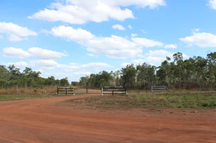
A wide dirt road leads towards a simple wooden farm-style gate, marking the entrance into a dry, grassy landscape with sparse trees under a blue sky.
An unpaved access road leading to the entrance of Piccaninny Plains Sanctuary.

Piccaninny Plains Sanctuary history and protected-area timeline

Piccaninny Plains functioned for many years as a cattle station on the Cape York Peninsula before its transformation into a conservation reserve. The pastoral history of the property followed the broader pattern of land use across inland Cape York, where vast cattle operations shaped the open tropical grasslands and savannas of the region for much of the twentieth century. This grazing legacy left enduring marks on the landscape, from pasture grasses to alterations in fire regimes, but it also left large tracts of land in a relatively undeveloped state compared with many other parts of tropical Australia.

The pivotal moment in the reserve's modern history came in 2008, when the property was purchased jointly by The Tony and Lisette Lewis Foundation and the Australian Wildlife Conservancy. The acquisition marked a deliberate shift from grazing to dedicated conservation management, converting a working cattle station into one of the largest private nature sanctuaries in northern Australia. The Australian Wildlife Conservancy took on the role of managing the land, bringing it into the organization's network of sanctuaries known for science-based ecological management, controlled burning programs, invasive species control, and long-term biodiversity monitoring.

Following the change in ownership and management, the reserve entered a new phase focused on ecological recovery. The reappearance of the Northern quoll on the property in 2025, the first recorded sighting in the area in more than eighty years, reflected the slow but tangible benefits of removing grazing pressure and restoring conservation management over a very large and continuous landscape. This event became an early milestone in the sanctuary's conservation record, signaling the capacity of the property to once again support species that had retreated from the broader region during the era of widespread pastoral and land use change.

Piccaninny Plains Sanctuary landscape and geographic character

Piccaninny Plains sits in the geographic interior of the Cape York Peninsula, a vast tropical landmass that forms the northern tip of the Australian continent. The sanctuary's terrain is defined by broad plains, gently undulating country, and the corridors of major rivers that cut through the property. The Archer River and the Wenlock River are the principal waterways, and their valleys give structure to the landscape, creating floodplains, riparian zones, and the gallery rainforests that line the larger watercourses. Away from the rivers, tropical grasslands dominate, giving way to woodland and seasonal wetland environments where soils and drainage allow.

The monsoon-driven climate imposes a strong seasonal pulse on the landscape. During the wet season from December to April, heavy rains swell the rivers and flood the low-lying plains, transforming large areas into shallow seasonal wetlands. As the dry season advances, these waters recede, and the grasslands become the dominant visual feature of the property. The contrast between the lush, inundated wet season and the drier, sun-bleached dry season creates one of the most defining rhythms of the Cape York interior, and Piccaninny Plains captures both extremes within its boundaries.

Surrounding the sanctuary are other major landscape elements that enhance its physical setting. Oyala Thumotang National Park lies adjacent to the property and continues many of the same habitat types into adjoining country, while Aboriginal-held lands further extend the unbroken sweep of tropical savanna. This broader landscape context gives Piccaninny Plains a sense of scale and continuity that few private reserves in Australia can match, situating the property as part of an enormous and largely natural region rather than an isolated conservation island.

Piccaninny Plains Sanctuary ecosystems, habitats, and plant life

Piccaninny Plains contains an unusually complete mosaic of the ecosystems that define central Cape York. Tropical grasslands are the most visually dominant habitat, supporting the savanna character that defines much of the peninsula's interior. These open landscapes are punctuated by gallery rainforests that hug the rivers and permanent creeks, creating narrow ribbons of closed-canopy forest that contrast sharply with the surrounding plains. Wetlands of various sizes appear across the property, particularly along the floodplains of the Archer and Wenlock Rivers, and they expand and contract dramatically with the annual monsoon rains.

The diversity of habitats on the property reflects the broader ecological richness of the Cape York Peninsula, one of the last large tropical regions in Australia where major ecological processes still operate across extensive areas. Fire is a defining ecological factor, with periodic burning shaping the structure of the grasslands and the boundaries between forest and savanna. The management of fire at Piccaninny Plains is therefore a central element of the reserve's ecological program, influencing vegetation patterns and habitat availability for the wildlife that depends on the mosaic of open and forested environments.

The sanctuary's position between the peninsula's east and west coasts is central to its ecological identity. By linking wetter eastern forests with drier western woodlands through a continuous band of protected habitat, the sanctuary contributes to the integrity of the region's broader ecological networks. The combination of intact grasslands, healthy riparian forests, functioning floodplains, and seasonally active wetlands gives the property an ecological depth that supports a wide array of tropical species, including birds, mammals, and reptiles that depend on the full range of Cape York habitats.

Piccaninny Plains Sanctuary wildlife and species highlights

The wildlife of Piccaninny Plains reflects the rich tropical fauna of the Cape York Peninsula. The reserve supports a mix of savanna, woodland, rainforest, and wetland species, benefiting from its large size and its connectivity with surrounding national parks and Aboriginal land. Among the bird species documented on the property are the palm cockatoo, the trumpet manucode, the yellow-billed kingfisher, and the magnificent riflebird, each of which is associated with different parts of the habitat mosaic. The palm cockatoo is particularly emblematic of Cape York's tropical woodlands, while the riflebird and manucode reflect the presence of rainforest elements along the property's waterways.

Mammals recorded at Piccaninny Plains include the spotted cuscus, a tree-dwelling marsupial associated with tropical rainforests and gallery forests. The reserve's mix of forest and open habitats provides important refuges for species that depend on both environments. Reptiles and amphibians also occupy the property in numbers typical of monsoonal tropical Australia, exploiting the wetlands, rivers, and grasslands that pulse with water during the wet season.

One of the most notable wildlife events in the sanctuary's short conservation history was the sighting in 2025 of a Northern quoll, the first documented occurrence in this part of Cape York in more than eighty years. The return of this small carnivorous marsupial is widely regarded as a hopeful sign that the conversion of the former cattle station to an actively managed sanctuary, combined with its connectedness to neighbouring reserves, is allowing species to recolonize landscapes from which they had been lost. The quoll's reappearance captures the broader conservation significance of Piccaninny Plains as a refuge for tropical wildlife under sustained, landscape-scale protection.

Piccaninny Plains Sanctuary conservation status and protection priorities

Piccaninny Plains Sanctuary is one of the largest privately protected areas in northern Australia and a cornerstone of conservation efforts on the Cape York Peninsula. Managed by the Australian Wildlife Conservancy and co-owned with The Tony and Lisette Lewis Foundation, the reserve plays a complementary role to surrounding national parks and Aboriginal-held conservation lands, helping to maintain a vast and largely unbroken belt of tropical wilderness. Its strategic position between the wetter east coast and the drier west coast of the peninsula makes it an essential link in the regional habitat corridor that allows wildlife to move across some of Australia's most intact tropical country.

The sanctuary's conservation value is rooted in the combination of its size, its diversity of habitats, and the intensity of management applied to it. The Australian Wildlife Conservancy employs scientific monitoring, targeted fire management, and invasive species control to maintain and restore ecological function across the property. These efforts are particularly important in a tropical savanna environment where fire regimes have a strong influence on vegetation structure and habitat availability for native fauna. By managing fire at a landscape scale, the sanctuary aims to preserve the mosaic of grasslands, forests, and wetlands that supports the region's biodiversity.

The return of the Northern quoll after an eighty-year absence stands as a tangible indicator of the reserve's conservation impact. It demonstrates that large, well-managed sanctuaries can serve as refuges for species whose ranges have contracted, and that the conversion of former pastoral land into dedicated conservation estates can yield measurable ecological benefits over time. Piccaninny Plains thus represents both a vital piece of the Cape York conservation network and a working example of how private reserves can contribute to the long-term resilience of tropical Australian wildlife.

Piccaninny Plains Sanctuary cultural meaning and human context

The name Piccaninny Plains derives from an outdated and offensive term historically used as a racial slur toward Aboriginal children. The retention of the historical name on a property now dedicated to conservation does not reflect endorsement of that language, and the place itself sits within a region of deep and ongoing Aboriginal cultural significance. The Cape York Peninsula is home to many Aboriginal peoples whose traditional lands connect directly with the sanctuary and its surroundings, and the reserve forms part of a broader landscape in which Aboriginal custodianship and conservation coexist.

The sanctuary's setting, bordered by Aboriginal-held land and by national parks that protect culturally important country, places it within a regional context where Indigenous connection to land is foundational. Recognition of this cultural setting is an important part of understanding the reserve's full significance, even as the property itself is primarily recognized for its ecological and conservation role.

Top sights and standout views in Piccaninny Plains Sanctuary

Piccaninny Plains Sanctuary stands out for its sheer scale within the Australian private conservation estate and for the diversity of habitats protected within a single property. Its tropical grasslands, gallery rainforests, wetlands, and floodplain systems capture a representative cross-section of central Cape York's ecological character, while the Archer and Wenlock Rivers tie these habitats together hydrologically and ecologically.

Equally distinctive is the sanctuary's role as a corridor linking the east and west coasts of the Cape York Peninsula through a continuous band of protected habitat. The documented return of the Northern quoll in 2025, alongside the continued presence of Cape York signature species such as the palm cockatoo, the trumpet manucode, and the spotted cuscus, highlights the reserve's growing significance for tropical wildlife conservation.

Best time to visit Piccaninny Plains Sanctuary

The experience of Piccaninny Plains is shaped strongly by the tropical monsoonal climate, with a clear distinction between the wet and dry seasons. The wet season, running roughly from December through April, brings the majority of the year's rainfall and transforms the property's floodplains and lowlands into expansive seasonal wetlands. This is a dynamic and visually dramatic period, with swollen rivers, lush vegetation, and intense wildlife activity around the water bodies, but the conditions are also challenging, with heavy rain, high humidity, and difficult access across much of the country.

The dry season, spanning roughly May through November, offers calmer and more accessible conditions. As floodwaters recede, the tropical grasslands dominate the landscape, and wildlife tends to concentrate around remaining water sources, making viewing more predictable. Cooler nights and milder daytime temperatures create more comfortable conditions for outdoor activity. Although the sanctuary is managed primarily for conservation rather than mass tourism, anyone visiting the region around this period generally encounters a wide-open tropical savanna in its characteristic dry-season form, complemented by permanent green ribbons of gallery forest along the rivers.


Monthly climate preview

Long term representative temperature and precipitation averages across the year

Piccaninny Plains Sanctuary Climate Normals and Annual Weather Rhythm

Representative coordinates record distinct seasonal shifts in temperature and precipitation across the sanctuary from 1991 to 2020. Examining the complete monthly climate normals reveals full baseline measurements for every month of the year.
Annual mean26 °C
23 °C29 °C
Jan27°
Feb27°
Mar26°
Apr25°
May24°
Jun23°
Jul23°
Aug24°
Sep26°
Oct28°
Nov29°
Dec28°
Warmest month
November

28.9 °C

Coolest month
July

22.6 °C

Wettest month
February

15 mm/day

Driest month
September

0.1 mm/day

Park location guide

Geography guide, regional context, and park location map for Piccaninny Plains Sanctuary

Piccaninny Plains Sanctuary park geography, regions, and map view in Australia

Understand where Piccaninny Plains Sanctuary sits in Australia through a broader geographic reading of the surrounding landscape, nearby location context, and its mapped position within the national park landscape.

How Piccaninny Plains Sanctuary fits into Australia

Australia is a constitutional monarchy and federal parliamentary democracy comprising six states and ten territories. With a population of nearly 28 million, it is one of the world's most urbanised countries, with most people concentrated on the eastern seaboard. The country has a high Human Development Index and is known for its cultural diversity, ancient Aboriginal heritage, and unique wildlife.

Wider geography shaping Piccaninny Plains Sanctuary in Australia

Australia occupies the entire Australian continent, the island of Tasmania, and numerous smaller islands. It is the world's flattest and driest inhabited continent, featuring vast deserts in the interior (the Outback), tropical rainforests along the eastern coast, and a coastline bordering the Indian and Pacific Oceans.

Map view of Piccaninny Plains Sanctuary

Use this park location map to pinpoint Piccaninny Plains Sanctuary in Australia, understand its exact geographic position, and read its mapped placement within the surrounding landscape more clearly.

Pigeon | © OpenStreetMap contributors

Location context for Piccaninny Plains Sanctuary

Queensland

Visualizing tropical savannas, gallery rainforests, and seasonal floodplains across Cape York Peninsula

Piccaninny Plains Sanctuary Photos and Landscape Scenery

Visual records reveal the diverse terrain and tropical habitats defining Piccaninny Plains Sanctuary across wet and dry seasons. Examining these protected landscapes provides clear insight into northern Australia conservation environments.

A wide dirt road leads towards a simple wooden farm-style gate, marking the entrance into a dry, grassy landscape with sparse trees under a blue sky.

Park atlas

Compare adjacent tropical reserves, regional national parks, and connected habitat corridors.

Parks Near Piccaninny Plains Sanctuary and Surrounding Cape York Protected Areas

Browse protected areas and national parks situated near Piccaninny Plains Sanctuary across the Cape York Peninsula. Comparing adjacent tropical reserves and surrounding regional terrain provides a broader geographic view of northern Australia conservation landscapes.
National parkAustralia
About 48 km away#1 closest

Southwest

Oyala Thumotang National Park: Australia's National Park Geographic Identity and Mapped Boundaries

Discover the landscape and regional context of this Australian protected area.

Oyala Thumotang National Park serves as a crucial element in Australia's protected lands network. This page offers detailed geographic information, focusing on the park's mapped boundaries, its role as a national park, and its contribution to the understanding of natural landscapes within the continent. Explore its specific location and the structured data available for regional atlas exploration and geographic analysis of Australian conservation areas.

Area
4,570 km²
Established
1994
IUCN
II
Relief
Mixed relief
A wide watercolor illustration showing green hills in the distance, a body of shallow water with pink and green patches, and foreground vegetation including green grasses and pink coral-like structures.
Marine protected areaQueensland
About 86 km away#2 closest

Southeast

Great Barrier Reef Marine Park: Atlas and Geographic Context for Queensland Protected Waters

Exploring the reef system and marine conservation zones in northeastern Australia

The Great Barrier Reef Marine Park stands as an internationally significant marine protected area. By spanning a massive stretch of the Queensland coast, this protected landscape provides a critical framework for marine governance and reef conservation. Users can examine the unique zoning and distribution of coral reef habitats that define this extensive tropical ecosystem.

Area
343,966 km²
Established
1975
Climate
Tropical
Scope
Marine
National parkQueensland
About 100 km away#3 closest

Northeast

Kutini-Payamu National Park: Queensland National Park Protected Landscape Explorer

Mapped natural terrain and geographic context within Queensland Australia.

Kutini-Payamu National Park is a significant protected area represented on the MoriAtlas platform as a distinct national park. This entry provides detailed insights into its geographic location within Queensland, Australia, detailing the park's protected landscape characteristics and its mapped natural features. Delve into the regional geography and understand the specific atlas context of this important conservation area, offering a clear view of its place within the broader natural terrain of northeastern Australia.

Area
346 km²
Established
1977
IUCN
II
Relief
Mixed relief
National parkAustralia
About 111 km away#4 closest

Northeast

Ma'alpiku Island National Park: A Detailed Look at Australia's Protected National Park Geography

Explore the mapped terrain and protected landscape of this Australian national park.

This MoriAtlas page offers an in-depth exploration of Ma'alpiku Island National Park, focusing on its identity as a protected natural area within Australia. Understand the park's geographic significance, its mapped boundaries, and the surrounding landscape context. It serves as a key resource for discovering the specific protected terrain and the broader regional geography that makes Ma'alpiku Island National Park a notable entity in the Australian conservation atlas.

Area
0.26 km²
Established
1989
Relief
Lowland
Climate
Tropical
National parkQueensland
About 125 km away#5 closest

Southeast

Claremont Isles National Park: Queensland's Protected Landscape and Geographic Identity

Atlas mapping and regional park context within northeastern Australia.

This entry for Claremont Isles National Park provides essential details for understanding its role as a protected landscape within Queensland. Explore its geographic attributes, mapped boundaries, and its contribution to the atlas of Australian conservation areas. The park's identity as a national park is highlighted, offering a specific focus for geographic discovery and landscape context within the northeastern Australian region.

Area
0.41 km²
Established
1989
IUCN
II
Relief
Lowland
National parkQueensland
About 126 km away#6 closest

Northeast

Piper Islands National Park: Queensland National Park with Critical Seabird Colonies

Explore mapped boundaries and landscape context for this Great Barrier Reef island sanctuary.

Piper Islands National Park in Queensland is a protected area comprising four coral cays vital for significant seabird nesting populations. Recognized as an Important Bird Area, these islands showcase distinct mangrove and Pisonia forest ecosystems against the backdrop of the inner northern Great Barrier Reef. The park's protected landscape offers a unique glimpse into the ecological importance of these small, dynamic coastal landforms within a world-heritage marine setting.

Area
0.07 km²
Established
1989
IUCN
II
Relief
Lowland
National parkQueensland
About 130 km away#7 closest

Northeast

Mitirinchi Island National Park: A Queensland National Park with Defined Protected Boundaries

Explore its unique Queensland geography and natural landscape.

Mitirinchi Island National Park is a designated national park located within Queensland, Australia, offering a specific point of focus for geographic and atlas exploration. This entity contributes to the understanding of protected land distribution across the northeastern Australian region. Examining Mitirinchi Island National Park allows for detailed appreciation of its mapped terrain and its role as a conservation landscape within the broader Queensland geography.

Area
0.012 km²
Established
1989
IUCN
II
Relief
Lowland
National parkQueensland
About 133 km away#8 closest

Northeast

Wuthara Island National Park: Protected Island Geography in Queensland's Coral Sea

Explore mapped coastal landscape and protected area context.

Wuthara Island National Park is a significant protected area located in the Coral Sea, contributing to Queensland's network of national parks. Its island geography and position within the Great Barrier Reef Marine Park region offer a unique perspective on coastal landscape conservation. This page provides detailed information to help users understand the park's role as a protected national park and its specific contribution to the mapped geography of tropical Australia.

Area
1.09 km²
Established
1990
IUCN
II
Relief
Lowland

Common questions about visiting, size, designation, and location context for Piccaninny Plains Sanctuary

Piccaninny Plains Sanctuary FAQs for park facts, access, geography, and protected area context

Find quick answers about Piccaninny Plains Sanctuary, including protected-area facts, park geography, trail and visitor context, and how the park fits into its surrounding country and regional landscape.
MoriAtlas Explorer

Continue Your Protected Areas Search Across the Global Atlas

Deepen your exploration by continuing the structured search for national parks and protected areas worldwide. Utilize the comprehensive filtering capabilities to compare different conservation landscapes and refine your understanding of global park geography. Discover more about the distribution and characteristics of protected natural areas.

Global natural geography