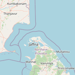
Why Pigeon Island National Park stands out
Pigeon Island is best known for its exceptional coral reef ecosystems, which rank among the finest remaining in Sri Lanka. The park protects critical marine habitats supporting diverse invertebrate and vertebrate communities, including reef sharks, multiple sea turtle species, and abundant fish populations. The terrestrial component features Large Pigeon Island as an important breeding ground for rock pigeons, lending the park its name. The combination of accessible coral reefs for snorkeling and scuba diving, along with the island's colonial history as a shooting range, gives this marine protected area a distinctive character within Sri Lanka's park system.
Pigeon Island National Park history and protected-area timeline
Pigeon Island's protected area status began in 1963 when it was designated as a sanctuary, recognizing the ecological importance of its coral reefs and the bird populations that gave the island its name. For four decades, the sanctuary status provided baseline protection for the marine and terrestrial environments. In 2003, the Sri Lankan government elevated Pigeon Island to national park status, becoming the 17th national park in the country and expanding the level of protection and management oversight. This re-designation reflected growing recognition of the reef's conservation significance and aligned with broader national strategies for marine protected area expansion. During the Sri Lankan civil war, which spanned approximately three decades, scientific research and monitoring in the park were significantly hindered. The park also experienced impacts from the 2004 Indian Ocean tsunami, which affected several protected areas along Sri Lanka's coastline including Pigeon Island.
Pigeon Island National Park landscape and geographic character
Pigeon Island National Park consists of two distinct islands set within the dry zone of Sri Lanka's Eastern Province. Large Pigeon Island measures approximately 200 meters in length and 100 meters in width, featuring a highest point of 44.8 meters above mean sea level and fringed by a well-developed coral reef. Small Pigeon Island differs in character, being surrounded by rocky islets rather than a continuous reef. The marine landscape centers on coral reef formations that vary in composition, with Acropora species dominating the reef around Large Pigeon Island while Montipora, Faviidae, Mussidae, and Poritidae species are more prominent around the rocky islets. Soft coral communities featuring Sinularia, Lobophyton, and Sarcophyton also occur within the park's waters.
Pigeon Island National Park ecosystems, habitats, and plant life
The marine ecosystems within Pigeon Island National Park represent some of the finest coral reef habitats in Sri Lanka. The reefs support high coral diversity with over 100 species recorded in the surrounding Trincomalee area, including both hard and soft coral formations. The coral reef fauna is dominated by Acropora species on the main island reef, while other coral families dominate around the rocky islets. These reef systems support extraordinary fish diversity, with approximately 300 coral reef fish species found in the broader area. The marine environment provides habitat for juvenile and adult blacktip reef sharks in shallow coral areas, while hawksbill turtles, green turtles, and olive ridley turtles visit the reef. The terrestrial environment features vegetation that supports the park's namesake rock pigeon, which uses the island as an important breeding ground.
Pigeon Island National Park wildlife and species highlights
The wildlife in Pigeon Island National Park spans both marine and terrestrial environments. The coral reef systems support diverse vertebrate and invertebrate communities, including numerous fish species that inhabit the reef structures. Blacktip reef sharks are commonly observed in the shallow coral areas, both as juveniles and adults. Sea turtle species including hawksbill turtles, green turtles, and olive ridleys visit the reef at various times. On land, the rock pigeon colony gives the island its name and represents a significant breeding population for this bird species. The fish community includes numerous coral reef-associated species, making the park important for marine biodiversity. The reef also supports invertebrate populations that form the base of the coral reef food web.
Pigeon Island National Park conservation status and protection priorities
Pigeon Island National Park faces several conservation challenges despite its protected status. The primary economic uses of the coral reef involve fishing and ornamental fish collection, which place pressure on marine resources. Tourism, particularly scuba diving and snorkeling activities, has grown uncontrolled and resulted in reef degradation and loss of biodiversity along with reduced fish density. Scientific research and monitoring were significantly disrupted during the decades-long Sri Lankan civil war, creating gaps in understanding of ecosystem changes. Proposals to construct a pier connecting the mainland to the island have attracted conservation criticism over potential impacts to the sensitive marine environment. The park remains significant as one of the best remaining coral reef areas in Sri Lanka and serves as an important reference site for marine conservation in the region.
Pigeon Island National Park cultural meaning and human context
Pigeon Island carries historical significance beyond its ecological value. During the British colonial period in Ceylon, the island was used as a shooting range, an activity that left historical traces on the island's landscape. This colonial-era use contributes to the layered human history of the site, though the primary identity today centers on marine conservation. The local community of Nilaveli on the mainland maintains connections to the island through fishing and tourism activities that intersect with the park's boundaries.
Top sights and standout views in Pigeon Island National Park
The standout features of Pigeon Island National Park include its accessibility from the coast near Trincomalee, the quality of its coral reefs considered among Sri Lanka's best, and the combination of marine and terrestrial environments within a single protected area. Visitors can observe reef sharks, multiple sea turtle species, and diverse fish populations while exploring the underwater environments. The rock pigeon breeding colonies on land provide birdwatching opportunities. The park's designation as a marine national park places it within a small group of only three such protected areas in Sri Lanka, underscoring its national significance for marine conservation.
Best time to visit Pigeon Island National Park
Pigeon Island National Park experiences a tropical climate within Sri Lanka's dry zone, with the northeastern monsoon bringing most rainfall from October through March. Mean annual temperatures hover around 27°C, creating warm conditions year-round. The monsoon season influences water conditions and visibility for underwater activities, with the period from April to September generally offering better conditions for snorkeling and diving. Visitors interested in marine wildlife viewing should consider seasonal patterns when planning trips, though the park remains accessible throughout the year.