Mori Atlas logo
Nature reservePrügelwiesen bei Wiesbaden in Breckenheim

Analyzing the mapped boundaries and wetland geography of this vital Hesse nature reserve

Prügelwiesen bei Wiesbaden in Breckenheim: A Protected Nature Reserve and Fen Landscape

(Naturschutzgebiet Prügelwiesen bei Wiesbaden in Breckenheim)

Prügelwiesen bei Wiesbaden in Breckenheim serves as a critical nature reserve within the state of Hesse, protecting a rare mosaic of calcareous fens and wet meadow habitats. This protected landscape preserves groundwater-fed soil gradients and traditional orchard meadows that represent essential ecological remnants in a suburban fringe region. By examining the mapped terrain, observers can understand how this small valley system maintains rare sedge beds and grassland communities across the transition from the Taunus foothills to the Main lowlands.

wetlandcalcareous fenmeadoworchard meadowgrassland conservationnature reserve

Prügelwiesen bei Wiesbaden in Breckenheim

Nature reserve

Park overview

Structured park overview, official facts, and landscape profile for Prügelwiesen bei Wiesbaden in Breckenheim

Prügelwiesen bei Wiesbaden in Breckenheim park facts, protected area profile, and essential visitor context

Review the core facts for Prügelwiesen bei Wiesbaden in Breckenheim, including designation, size, terrain, visitor scale, habitats, and operating context in one park-focused overview.

About Prügelwiesen bei Wiesbaden in Breckenheim

Prügelwiesen bei Wiesbaden in Breckenheim is a compact but ecologically rich protected area tucked into a small valley east of Breckenheim, one of Wiesbaden's outlying districts. Despite covering only a few hectares, the reserve plays an outsize role in conserving wetland and grassland habitats that are otherwise under heavy pressure in the Rhine-Main region.

The site lies at the meeting point of two natural regions: the flatter, agriculturally shaped Main-Taunusvorland to the south and the more rounded, forested Vortaunus to the north. This transitional position, combined with groundwater emerging from the slopes, has produced the soil conditions that allow calcareous fens to develop. Within the reserve, a mosaic of habitats includes calcareous fen flat meadows, sedge beds dominated by Davall's sedge, wet and moist grasslands, and orchard meadows (Streuobstwiesen) along the edges and upper slopes.

The protected area's purpose is explicitly tied to maintaining this habitat mosaic in working condition. Conservation management aims to preserve the natural balance of the site, safeguard the biotopes and species present, and protect the visual character of the rural landscape. To keep the grassland communities species-rich, the area is managed through extensive agricultural use, conversion of former arable land into grassland, and ongoing care of the traditional orchard trees. The reserve is administered by Hessen-Forst from the Chausseehaus forestry office, which oversees habitat maintenance across this part of Wiesbaden.

Although the reserve is not a major tourism destination, it exemplifies the type of small-scale, ecologically focused nature reserve that is central to Germany's Naturschutzgebiet system. Its quiet fen meadows, declining Davall's sedge populations, and surviving wetland insects give it clear scientific and conservation value within the network of protected sites in Wiesbaden.

Quick facts and research context for Prügelwiesen bei Wiesbaden in Breckenheim

Prügelwiesen bei Wiesbaden in Breckenheim is a German nature reserve (Naturschutzgebiet) covering about 7.9 hectares on the eastern edge of the Wiesbaden district of Breckenheim in Hesse. It was designated on 14 December 1994 under IUCN Category IV as a habitat and species management area. The reserve lies between the natural regions of Main-Taunusvorland and Vortaunus at elevations of roughly 180 to 210 meters above sea level, and it is managed by Hessen-Forst from the Chausseehaus forestry office.

Protection and recognition

Documented terrestrial protection scope, management records, and verified international registry data.

Prügelwiesen bei Wiesbaden in Breckenheim Protection Status and Territorial Designation

Prügelwiesen bei Wiesbaden in Breckenheim holds a documented terrestrial protection scope cataloged within official global databases. Official records outline the verified administrative designation parameters and baseline environmental jurisdiction without external recognition sources.

Protection details

Protection scope
Terrestrial
Transboundary protection
No
WDPA ID
165049
Park context

Deeper park guide and search-rich context for Prügelwiesen bei Wiesbaden in Breckenheim

Prügelwiesen bei Wiesbaden in Breckenheim history, landscape, wildlife, and travel context

Explore Prügelwiesen bei Wiesbaden in Breckenheim through its history, landscape character, ecosystems, wildlife, conservation priorities, cultural context, and seasonal travel timing in a structured park guide built for atlas discovery and search intent.

Why Prügelwiesen bei Wiesbaden in Breckenheim stands out

The reserve is best known for protecting a calcareous fen flat meadows complex with Davall's sedge (Davalls Segge), sedge beds, wet and moist meadows, and adjoining orchard meadows. It is distinctive because these species-rich fen and grassland communities still survive in an intensively used agricultural and suburban region around Wiesbaden, and because it supports rare and declining species such as adder's tongue ferns and specialized wetland insects.
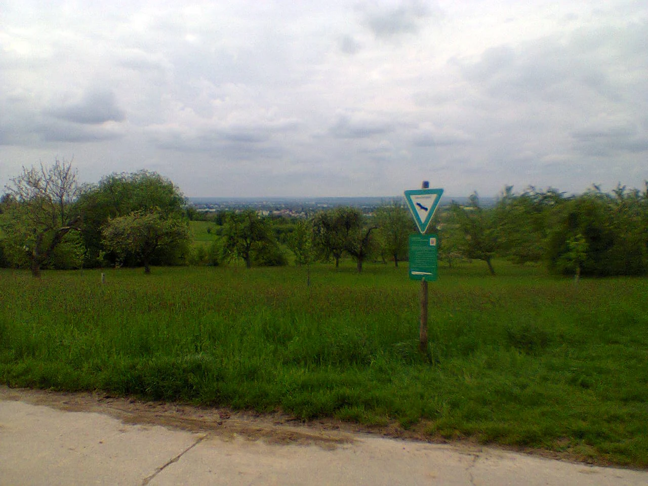
A nature reserve sign with a green triangle symbol stands in a grassy field with trees under a cloudy sky.
A nature reserve sign marking the Prügelwiesen area in Wiesbaden-Breckenheim.

Prügelwiesen bei Wiesbaden in Breckenheim history and protected-area timeline

The Prügelwiesen area has a long history of traditional rural use. The place name itself is documented as early as 1363, when the site was recorded as "gein der Brulwysen," a form that traces back to the old German toponym Brühl, meaning meadows, woodland, or wet ground. This linguistic record indicates that the area's character as low-lying wet meadows has been recognized for centuries.

The modern protected status came relatively recently. On 14 December 1994, the area was formally designated as a Naturschutzgebiet under Hessian nature conservation law, creating the Prügelwiesen bei Wiesbaden in Breckenheim reserve as it exists today. The designation reflected growing awareness that these small fen and meadow complexes were being lost to intensification of agriculture and suburban expansion around Wiesbaden. Since its establishment, the reserve has been integrated into the city's broader network of protected natural areas and has been managed by Hessen-Forst from the Chausseehaus forestry office, with the explicit aim of preserving both its ecological value and its cultural-landscape character, including the traditional orchard meadows surrounding the wet core.

Prügelwiesen bei Wiesbaden in Breckenheim landscape and geographic character

The landscape of Prügelwiesen is shaped by a small valley setting east of Breckenheim, where gentle slopes descend into a low-lying, groundwater-influenced basin. Elevations across the reserve range only from about 180 to 210 meters above sea level, but this modest relief is enough to create the soil and moisture gradients that define the site.

Geologically and regionally, the reserve sits in the transitional belt between the Main-Taunusvorland and the Vortaunus. The flatter agricultural land of the foothills gives way to the wooded and undulating terrain of the Taunus foreland, and it is in this transition that the fen and wet meadows have survived. Calcareous seepage from the slopes feeds the basin, producing the conditions needed for calcareous flat fens and sedge beds, while the fringes of the valley carry drier, more traditionally managed grassland and orchard meadow.

A small watercourse rises from the spring mires at the heart of the reserve. Originally an open stream, it has been piped underground and flows onward into the Klingenbach, which in turn drains through the Wickerbach into the Main river. This subtle hydrological link ties the reserve into the larger Rhine-Main watershed and explains why such groundwater-fed habitats remain possible on the edge of a densely populated metropolitan region.

Prügelwiesen bei Wiesbaden in Breckenheim ecosystems, habitats, and plant life

Ecologically, Prügelwiesen is defined by a tight mosaic of calcareous fen, wet and moist meadow, sedge bed, and orchard meadow habitats packed into just a few hectares. The most important element is the calcareous flat fen with Davall's sedge, a plant community now considered highly threatened across Hesse and much of central Germany. Around the fen, sedge formations dominated by Davall's sedge give way to wet meadows and then to orchard-covered slopes.

The reserve's flora includes the strong-to-strongly endangered adder's tongue ferns of the genus Ophioglossum, a small group of plants that depend on the short, species-rich, lightly grazed turf maintained by the fen conditions. These rare ferns are among the botanical highlights of the site and underline how much ecological meaning is concentrated in a small area.

Vegetation management is built into the conservation concept. The goal is to maintain the species-rich grassland community through extensive agricultural use, to convert remaining arable land into permanent grassland, and to actively manage the orchard meadows that frame the wetter core. Together, these measures sustain the openness of the landscape and the habitat structure that the rare plants and insects depend on.

Prügelwiesen bei Wiesbaden in Breckenheim wildlife and species highlights

Although the reserve's fame is primarily botanical, it also supports a distinctive small-scale fauna typical of well-preserved calcareous fens and wet meadows. Among the invertebrates, the site is notable for the Kamelläufer, a ground beetle associated with the open, lightly grazed fen habitat, and for the rare Sumpfschrecke, a wetland bush-cricket that depends on similar conditions.

Birdlife is shaped by the surrounding orchard meadows and the mosaic of grassland and scrub, supporting typical species of traditional German rural landscapes. The reserve's small size means wildlife conservation is closely tied to maintaining habitat quality rather than to supporting large mammals or wide-ranging species. The adder's tongue ferns and the dependent invertebrate community, including these specialized beetles and grasshoppers, are the most characteristic and conservation-relevant animal and plant associations in the area.

Population status is a concern: Davall's sedge, the linchpin species of the fen community, was still documented at the site in 2015, but only at very low numbers and with a clearly declining trend. This makes the reserve an important refuge for a species and a community that are otherwise retreating from the region.

Prügelwiesen bei Wiesbaden in Breckenheim conservation status and protection priorities

Prügelwiesen bei Wiesbaden in Breckenheim was designated as a nature reserve to maintain the natural balance, biotope value, species conservation importance, and landscape character of a small but unusually rich complex of calcareous fen and wet meadow habitats. The site's conservation value lies in the persistence of Davall's sedge fens and associated plant communities in an area otherwise dominated by intensive farming and suburban development around Wiesbaden.

The protection regime emphasizes active management rather than simple exclusion. The reserve is to be kept in a state of extensive agricultural use, arable land converted to grassland, and the extensively managed orchard meadows carefully tended. These measures are intended to preserve the openness of the habitat, the diversity of the grassland community, and the traditional landscape mosaic of orchards, meadows, and wet ground. The reserve is administered by Hessen-Forst from the Chausseehaus forestry office, integrating it into state-level habitat management. It sits within the broader network of Naturschutzgebiete within Wiesbaden and contributes to maintaining ecological connectivity in the transition zone between the Main-Taunus foothills and the Vortaunus.

Prügelwiesen bei Wiesbaden in Breckenheim cultural meaning and human context

The reserve carries a layered cultural imprint that goes back at least to the medieval period. Its place name is documented in 1363 as "gein der Brulwysen," derived from the older German toponym Brühl, which described meadows, woodland, or wet ground. The continuation of this name into a modern protected area reflects how strongly the rural identity of the landscape has been tied to its wet-meadow character.

Culturally, the surrounding Streuobstwiesen, traditional orchard meadows with scattered fruit trees, are a key element of the European rural heritage typical of Hesse and other parts of central Germany. These orchards form both a visual and an ecological frame around the fen core of the reserve, blending working agriculture with conservation. Their inclusion in the protected area reflects a wider German conservation practice of safeguarding cultural landscapes alongside purely natural habitats.

Top sights and standout views in Prügelwiesen bei Wiesbaden in Breckenheim

The defining highlights of Prügelwiesen lie in the survival of a calcareous fen complex, the occurrence of Davall's sedge, the presence of rare adder's tongue ferns, and the integration of wet meadows with traditional orchard meadows. The reserve demonstrates how a small, intensively managed Naturschutzgebiet can protect disproportionately important fen and grassland biodiversity on the edge of a major metropolitan region.

Best time to visit Prügelwiesen bei Wiesbaden in Breckenheim

The reserve is best appreciated in late spring and early summer, when the species-rich wet meadows and calcareous fens are at their most diverse flowering and when the surrounding orchard meadows are in blossom. Late spring is also a good time to observe wetland insects such as the rare Sumpfschrecke. Summer visits allow extended grassland views but can coincide with management mowing. As a small wetland reserve, winter conditions emphasize the muted, damp character of the fen valley rather than active wildlife displays.

Monthly climate preview

Long-term representative point measurements tracking monthly temperature and precipitation variation

Climate Normals and Annual Temperature Rhythm for Prügelwiesen bei Wiesbaden in Breckenheim

Representative coordinates record measured multi-year temperature ranges alongside daily precipitation averages across twelve distinct monthly intervals. Detailed month-by-month climate profiles provide comprehensive long-term atmospheric data for this protected area.
Annual mean9 °C
0 °C20 °C
Jan
Feb
Mar
Apr
May13°
Jun17°
Jul20°
Aug19°
Sep15°
Oct
Nov
Dec
Warmest month
July

19.6 °C

Coolest month
January

-0.1 °C

Wettest month
July

2.2 mm/day

Driest month
April

1.5 mm/day

Park location guide

Geography guide, regional context, and park location map for Prügelwiesen bei Wiesbaden in Breckenheim

Prügelwiesen bei Wiesbaden in Breckenheim park geography, regions, and map view in Germany

Understand where Prügelwiesen bei Wiesbaden in Breckenheim sits in Germany through a broader geographic reading of the surrounding landscape, nearby location context, and its mapped position within the national park landscape.

How Prügelwiesen bei Wiesbaden in Breckenheim fits into Germany

Germany is a federal republic in Western and Central Europe with a population of over 83 million across sixteen constituent states. It is Europe's largest economy by nominal GDP and a major global exporter and importer. The capital is Berlin, and the country borders Denmark, Poland, Czech Republic, Austria, Switzerland, France, Luxembourg, Belgium, and the Netherlands.

Wider geography shaping Prügelwiesen bei Wiesbaden in Breckenheim in Germany

Germany is located in Western and Central Europe, spanning 357,022 km². It borders Denmark to the north, Poland and the Czech Republic to the east, Austria and Switzerland to the south, and France, Luxembourg, Belgium, and the Netherlands to the west. The country has coastlines on the Baltic Sea and North Sea to the north, with the Alps located in the southern region.

Map view of Prügelwiesen bei Wiesbaden in Breckenheim

Use this park location map to pinpoint Prügelwiesen bei Wiesbaden in Breckenheim in Germany, understand its exact geographic position, and read its mapped placement within the surrounding landscape more clearly.

Pigeon | © OpenStreetMap contributors

Location context for Prügelwiesen bei Wiesbaden in Breckenheim

Hesse

Explore the wetland terrain, calcareous fens, and meadow habitats through field photography.

Visualizing Prügelwiesen bei Wiesbaden in Breckenheim Photos and Protected Landscapes

Examine detailed park photography to understand the distinct valley topography, groundwater-fed fens, and transitional meadow habitats preserved within Prügelwiesen bei Wiesbaden in Breckenheim. Visual reference materials reveal the subtle ecological character and preserved grassland mosaics defining this regional protected area.

A nature reserve sign with a green triangle symbol stands in a grassy field with trees under a cloudy sky.

Park atlas

Compare nearby nature reserves and regional wetland habitats across the Taunus foothills

Parks Near Prügelwiesen bei Wiesbaden in Breckenheim and Surrounding Protected Landscapes

Continue exploring protected areas near Prügelwiesen bei Wiesbaden in Breckenheim to examine similar wetland reserves, valley basins, and grassland habitats throughout the regional watershed. Comparing adjacent conservation landscapes reveals how small nature reserves maintain ecological continuity across the suburban transition zone.
A soft watercolor painting depicting rolling green hills and a forested landscape under a pale, sunrise-hued sky.
Nature reserveHessen
About 8.4 km away#1 closest

North

Rossert - Hainkopf - Dachsbau Nature Reserve: Geography and Protected Taunus Forest Landscapes

A preserved ridge system in the Hessen region of Germany

The Rossert - Hainkopf - Dachsbau nature reserve represents a compact but ecologically vital ridge system in the Taunus foothills. Spanning over 120 hectares of mixed forest, this protected area preserves the transition between woodland and open meadow while securing the headwaters of the Wellbach stream within its geographic boundaries.

Area
1.19 km²
Established
1977
IUCN
IV
Nature reserveHessen
About 8.5 km away#2 closest

North

Krebsbachtal bei Ruppertshain: Protected Stream Valley and Conservation Geography

Nature reserve and FFH site in the Hessian Taunus

Located in the western foothills of the Taunus, Krebsbachtal bei Ruppertshain is a protected nature reserve and Natura 2000 site. It features a linear valley landscape defined by the Fischbach stream corridor and dense mixed deciduous forest. The reserve plays a crucial role in maintaining regional ecological continuity within the Rhine-Main area, providing a distinct geographic boundary near the Rossert massif.

Area
0.845 km²
Established
1992
IUCN
IV
Relief
Upland
A watercolor painting showing a soft, atmospheric landscape with a river flowing through green hills and gentle, misty mountains.
Nature reserveRhineland-Palatinate
About 11 km away#3 closest

Southwest

Inselrhein Nature Reserve, Rhineland-Palatinate: A Geographic and Protected-Area Atlas

River islands, floodplain forests, and Upper Rhine wetlands

Inselrhein features a chain of natural river islands and side channels forming a critical wetland habitat. The terrain transition from soft-wood to hardwood forest communities creates a layered landscape. Examine the protected boundaries and geographic significance of this river corridor between Mainz and Bingen, documented within the Rhineland-Palatinate atlas.

Relief
Lowland
Climate
Temperate
Access
Easy access
Scope
Terrestrial
A watercolor illustration of a landscape with green meadows, flowering bushes, and distant rolling hills on a white background.
Nature reserveHesse
About 11 km away#4 closest

West

Rabengrund von Wiesbaden: Mapping Protected Landscapes and Habitats in Hesse

Nature reserve and FFH site in the Taunus foothills

Rabengrund von Wiesbaden serves as a distinct protected valley system characterized by a compact coexistence of acid grasslands, reedbeds, and orchid-rich meadows. Managed as both a nature reserve and a Natura 2000 site, this area provides a rare window into the historical cultural landscape of the Taunus region. The site offers essential insight into small-scale habitat diversity near the urban core of the Hessian state capital.

Area
0.791 km²
Established
1988
IUCN
IV
Relief
Upland
A wide watercolor illustration showing a winding river flowing through a green floodplain with scattered trees and pale pink and purple hills in the distance.
Nature reserveHesse
About 13 km away#5 closest

Southwest

Rettbergsaue Nature Reserve: Geography and Protected Landscapes in the Rhine Valley

A vital river island ecosystem and floodplain forest in Hesse.

Rettbergsaue serves as an essential riverine habitat in the Upper Rhine. This nature reserve, characterized by its alluvial woodland and riparian meadows, offers a detailed study of sediment-formed islands and the interplay between main-channel water flow and sheltered side-arm environments within the state of Hesse.

Area
0.68 km²
Established
1978
Relief
Lowland
Climate
Temperate
A watercolor illustration of a serene valley landscape with a small winding stream running through grassy meadows, bordered by trees in the distance.
Nature reserveHesse
About 13 km away#6 closest

North

Dattenbachtal zwischen Kröftel und Vockenhausen Nature Reserve in Hesse, Germany

Stream valley and protected riparian landscape mapping

This nature reserve protects a vital section of the Dattenbach stream valley between the villages of Kröftel and Vockenhausen. Spanning cross-district boundaries in the Taunus foothills, the site is defined by its two-parcel structure and its role in preserving headwater stream habitats within the larger Hessian landscape.

Area
0.909 km²
Established
1993
A horizontal watercolor painting showing a soft, impressionistic landscape with rolling green hills and patches of forest under a pale, muted sky.
Nature reserveHessen
About 13 km away#7 closest

Northeast

Burghain Falkenstein Nature Reserve: Protected Woodland Map and Regional Geography

A forest enclave in the Taunus uplands of Hessen, Germany

Burghain Falkenstein stands as a prominent nature reserve and Natura 2000 site located on the slopes of the Burgberg. This compact protected area features a mosaic of beech and ravine forests, providing a rare green massif amidst the urban sprawl of the Taunus foothills. The reserve documents a complex history where natural woodland succession intersects with medieval fortification remains, offering a concentrated study of regional forest geography near Frankfurt am Main.

Area
0.363 km²
Established
1966
IUCN
IV
Relief
Mountain
Watercolor painting of a green wetland landscape with a winding river and distant blue hills against a pale sky.
Nature reserveRhineland-Palatinate
About 15 km away#8 closest

South

Laubenheimer-Bodenheimer Ried Nature Reserve in Rhineland-Palatinate: An Atlas of Protected Floodplain Habitats

A vital protected mosaic of reedbeds, wet meadows, and rare dike grasslands in the Upper Rhine region.

The Laubenheimer-Bodenheimer Ried functions as a crucial nature reserve that captures the historical movement of the Rhine through its network of ponds and channels. This area protects a high concentration of botanical diversity and serves as a landmark for regional birding, centered around its prominent stork colony. The reserve offers a clear look at how human-modified landscapes, such as former clay pits, have transitioned into high-value conservation sites.

Area
1.8 km²
Established
1982
Relief
Lowland
Climate
Temperate

Common questions about visiting, size, designation, and location context for Prügelwiesen bei Wiesbaden in Breckenheim

Prügelwiesen bei Wiesbaden in Breckenheim FAQs for park facts, access, geography, and protected area context

Find quick answers about Prügelwiesen bei Wiesbaden in Breckenheim, including protected-area facts, park geography, trail and visitor context, and how the park fits into its surrounding country and regional landscape.
MoriAtlas Explorer

Continue Your Protected Areas Search Across the Global Atlas

Deepen your exploration by continuing the structured search for national parks and protected areas worldwide. Utilize the comprehensive filtering capabilities to compare different conservation landscapes and refine your understanding of global park geography. Discover more about the distribution and characteristics of protected natural areas.

Global natural geography