
Mori Atlas logo
Nature reserveNaturschutzgebiet Quellgebiet der Henne

Examining the hydrology and ash-dominated forest geography of the upper Henne river watershed.

Naturschutzgebiet Quellgebiet der Henne: A Protected Forest and Springhead Landscape in Nordrhein-Westfalen

The Naturschutzgebiet Quellgebiet der Henne preserves a vital upland springhead forest within the Rothaargebirge foothills of Nordrhein-Westfalen. This protected area safeguards the source streams of the Henne river, maintaining essential hydrological conditions and a moisture-rich microclimate for specialized spring flora. The reserve represents a key segment of the Sauerland upland landscape, characterized by its narrow wooded valleys and consistent forest cover.

nature reserveprotected forestspringheadheadwatersmixed forestash forest
An illustration showing a river flowing through a deep valley between rocky cliffs and pine forests, with distant mountains under a soft sky.

Naturschutzgebiet Quellgebiet der Henne

Nature reserve

Park overview

Structured park overview, official facts, and landscape profile for Quellgebiet der Henne Nature Reserve

Quellgebiet der Henne Nature Reserve park facts, protected area profile, and essential visitor context

Review the core facts for Quellgebiet der Henne Nature Reserve, including designation, size, terrain, visitor scale, habitats, and operating context in one park-focused overview.

About Quellgebiet der Henne Nature Reserve

The Quellgebiet der Henne Nature Reserve is a focused, small-scale conservation area in the Rothaargebirge foothills of the Sauerland. It lies southwest of Rimberg, within the city of Schmallenberg, and encompasses the uppermost watershed of the Henne, a stream that ultimately flows northward through the Hochsauerland district. By concentrating protection on the forested sources rather than on a larger landscape, the reserve reflects a deliberate management approach aimed at the sensitive headwater zone where water quality, soil conditions, and forest composition intersect.

The protected landscape is shaped by two parallel source brooks that emerge close together and run northward along shallow wooded valleys. The surrounding slopes are clothed in a mixed forest in which European ash dominates and Norway spruce occurs as an accompanying species. This forest type is characteristic of moist, nutrient-rich spring areas in central German uplands, where the cool microclimate created by groundwater seepage supports shade-tolerant herbaceous plants and a stable, humid forest floor.

Designated in 2008, the reserve marks one of many targeted conservation efforts by the Hochsauerland district to safeguard individual ecologically valuable features within its broader landscape planning framework. The Schmallenberg Südost landscape plan provides the overarching context for the protection, and the area is administered by the regional lower landscape authority. Its IUCN Category IV status places it among Germany's habitat and species management areas, underscoring that its primary value is the preservation of a specific natural habitat rather than a broad wilderness or scenic landscape.

Despite its modest extent, the reserve illustrates a broader principle of European conservation: the recognition that small springhead forests are disproportionately important for regional hydrology and biodiversity. Protecting these zones helps maintain clean groundwater discharge, retains characteristic spring vegetation, and provides refuge for species that depend on stable, cool, humid conditions rarely found in more open or disturbed landscapes.

Quick facts and research context for Quellgebiet der Henne Nature Reserve

The Quellgebiet der Henne Nature Reserve covers roughly 10.7 hectares in the municipal area of Schmallenberg, Hochsauerlandkreis, North Rhine-Westphalia. It carries the official designation HSK-563 and is managed by the lower landscape authority of the Hochsauerland district.

It was designated under the Schmallenberg Südost landscape plan in 2008. The reserve is classified as an IUCN Category IV area, recognizing it as a habitat and species management zone focused on conserving the springhead forest ecosystem of the Henne river.

Protection and recognition

Examine documented protection metrics and official designation records for Naturschutzgebiet Quellgebiet der Henne.

Naturschutzgebiet Quellgebiet der Henne Protection Status and Records

Examine recorded protection metrics and official designation details associated with Naturschutzgebiet Quellgebiet der Henne. Review verified database identifiers and international conservation recognition sources linked to the reserve.

Protection details

WDPA ID
389865
Park context

Deeper park guide and search-rich context for Quellgebiet der Henne Nature Reserve

Quellgebiet der Henne Nature Reserve history, landscape, wildlife, and travel context

Explore Quellgebiet der Henne Nature Reserve through its history, landscape character, ecosystems, wildlife, conservation priorities, cultural context, and seasonal travel timing in a structured park guide built for atlas discovery and search intent.

Why Quellgebiet der Henne Nature Reserve stands out

The reserve is best known for protecting the wooded spring area of the Henne river, including both of its source streams and the small valleys through which they flow. Its defining feature is the ash-dominated mixed forest that frames the cold, moist conditions of a Sauerland upland spring, supporting characteristic spring flora such as bittercress, opposite-leaved golden saxifrage, and marsh forget-me-not.
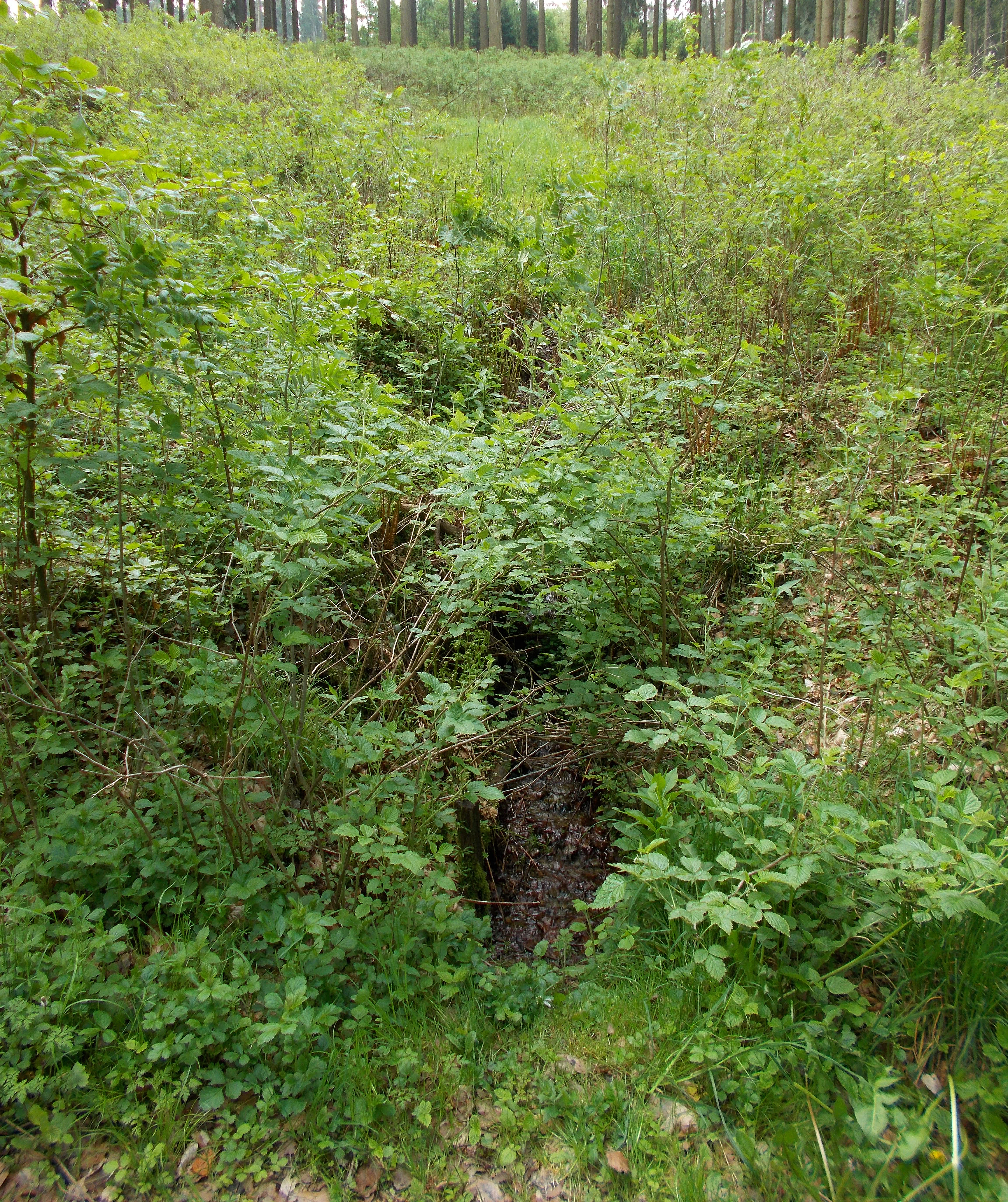
A small, narrow channel of water emerges from a dense, verdant patch of forest vegetation and low shrubs.
The spring area of the Henne river, the namesake and primary natural feature of the Quellgebiet der Henne nature reserve.

Quellgebiet der Henne Nature Reserve history and protected-area timeline

The Quellgebiet der Henne Nature Reserve was formally designated in 2008 through the Schmallenberg Südost landscape plan, which was prepared and issued by the Hochsauerland district. The establishment came as part of a systematic effort to identify and protect ecologically valuable sites within the municipal area of Schmallenberg, including the headwater forests of regional streams.

The underlying rationale for the designation, as noted in the official protection order, cites the rarity, distinctive character, and natural beauty of the area, a standard justification used across German nature reserves. This formal recognition placed the springhead forest of the Henne under the protections afforded to nature reserves under German federal and state conservation law, restricting land use activities that could compromise the forest and hydrological system.

The reserve represents one stage in a longer regional history of landscape planning in the Hochsauerland district, where successive landscape plans have progressively built a network of protected forest and meadow sites. Although the reserve itself is relatively new as a formal designation, the forest it protects reflects long-standing land use patterns of the Sauerland, where steep valleys and poor soils historically supported continuous forest cover rather than intensive agriculture.

Quellgebiet der Henne Nature Reserve landscape and geographic character

The reserve occupies a characteristic segment of the Sauerland upland landscape, a region of rolling forested hills, narrow valleys, and consistent elevations around the watershed divide of the Rothaargebirge. In this setting, the protected area lies on gently sloping terrain shaped by the headwater erosion of the Henne and its tributaries, with shallow valleys cutting northward into the surrounding hillsides.

The two source brooks of the Henne define the local relief, creating a corridor of low ground flanked by slightly steeper forested slopes. The streams are small and slow-flowing, fed by groundwater seepage that keeps their channels cool and stable through much of the year. This setting produces a sheltered, humid microclimate along the brook corridors that contrasts subtly with the drier, more exposed slopes above.

Throughout the reserve, the surface is largely covered by forest canopy, with only minimal openings along the immediate stream margins. The topographic setting is modest but ecologically significant, since the springhead represents the highest, most sensitive point in the Henne watershed, where hydrological processes are most easily disrupted.

Quellgebiet der Henne Nature Reserve ecosystems, habitats, and plant life

Ecologically, the reserve is defined by its ash-dominated mixed forest, a forest community typical of moist, base-rich streambank environments in central European uplands. European ash forms the structural backbone of the woodland, accompanied by Norway spruce that lends coniferous character to portions of the canopy. This mixture produces a shaded, humid interior that limits ground-level plant diversity in some areas while supporting a specialized flora along the watercourses.

The forest floor reflects the moisture and nutrient gradient typical of upland spring forests. Cool, shaded conditions along the brooks favor moisture-dependent species such as bittercress, opposite-leaved golden saxifrage, and marsh forget-me-not, alongside broader spring forest indicators including woodruff, wood sorrel, and intermediate enchanter's nightshade. Ferns such as oak fern and broad buckler fern contribute to the understory in places, while soft rush indicates persistently damp soil conditions.

Beyond the immediate stream corridors, the surrounding wooded slopes carry a more standard mixture of forest species, including sycamore maple, that reflect the broader mixed deciduous character of the Rothaargebirge foothills. The combination of stable hydrology, intact forest cover, and limited disturbance makes the springhead ecosystem one of the more ecologically distinctive forest units in the Schmallenberg area.

Quellgebiet der Henne Nature Reserve wildlife and species highlights

Although the source provides no formal species inventory of the reserve's fauna, the forest and stream habitat supports the typical wildlife community of a small Sauerland upland forest: forest birds, small forest mammals, and invertebrates associated with cool, shaded spring brooks. The undisturbed spring zones and mature mixed forest provide habitat structure that is increasingly rare in more heavily used parts of the surrounding landscape.

Quellgebiet der Henne Nature Reserve conservation status and protection priorities

The reserve's principal conservation value lies in protecting the springhead of the Henne and the associated spring forest, a habitat that is both rare locally and ecologically sensitive. By keeping the uppermost section of the catchment under nature reserve status, the designation secures groundwater discharge patterns, retains the characteristic mixed forest structure, and prevents land use changes that could alter the hydrology or species composition of the spring area.

Its IUCN Category IV classification reflects this management orientation, recognizing the site as a habitat and species management area. The reserve fits into a wider network of protected forest and meadow sites across the Hochsauerland district, contributing to the district's broader effort to maintain ecological connectivity and to safeguard representative examples of the region's natural habitats. Even as a small site, the reserve provides a reference point for the type of springhead forest community that once would have been more widespread across the Rothaargebirge.

Quellgebiet der Henne Nature Reserve cultural meaning and human context

The reserve sits within the Sauerland, a region historically shaped by small-scale forestry, scattered farmsteads, and a scarcity of large-scale agriculture due to its soils and elevation. The protection of the Henne springhead reflects the modern Sauerland's continued emphasis on landscape and forest preservation, in which traditional land use patterns have given way to managed woodland, conservation, and recreation. The reserve's formal designation through a landscape plan also illustrates the strong role of regional planning institutions in shaping environmental protection in North Rhine-Westphalia.

Top sights and standout views in Quellgebiet der Henne Nature Reserve

The reserve's standout qualities are concentrated rather than expansive: a compact, intact springhead forest; two parallel source brooks forming the beginning of the Henne; an ash-dominated mixed woodland sheltering moisture-loving spring flora; and a formal protection status that anchors the area within the Hochsauerland district's broader conservation network. Together these features make the site a clear example of targeted headwater protection in the Rothaargebirge foothills.

Best time to visit Quellgebiet der Henne Nature Reserve

The reserve is best experienced in the warmer months, when the spring forest is most visually accessible and the herbaceous spring flora along the brooks is at its most active. Late spring and early summer offer the richest display of moisture-dependent understory plants, while early autumn brings color to the mixed ash and spruce canopy. Cool, damp conditions near the brooks remain a feature of the site throughout the year, so visitors should expect shaded and humid ground conditions regardless of season.

Monthly climate preview

Long term temperature and precipitation measurements across twelve monthly observation cycles

Naturschutzgebiet Quellgebiet der Henne Climate Normals and Annual Temperature Rhythm

Representative coordinate sampling records long term average monthly temperature variation alongside consistent daily precipitation patterns for Naturschutzgebiet Quellgebiet der Henne. Examining the complete twelve month climate profile reveals detailed temperature bounds and precipitation rates across the protected area.
Annual mean8 °C
-1 °C17 °C
Jan-1°
Feb
Mar
Apr
May12°
Jun15°
Jul17°
Aug17°
Sep13°
Oct
Nov
Dec
Warmest month
July

17.4 °C

Coolest month
January

-0.7 °C

Wettest month
December

3 mm/day

Driest month
April

1.8 mm/day

Park location guide

Geography guide, regional context, and park location map for Quellgebiet der Henne Nature Reserve

Quellgebiet der Henne Nature Reserve park geography, regions, and map view in Germany

Understand where Quellgebiet der Henne Nature Reserve sits in Germany through a broader geographic reading of the surrounding landscape, nearby location context, and its mapped position within the national park landscape.

How Quellgebiet der Henne Nature Reserve fits into Germany

Germany is a federal republic in Western and Central Europe with a population of over 83 million across sixteen constituent states. It is Europe's largest economy by nominal GDP and a major global exporter and importer. The capital is Berlin, and the country borders Denmark, Poland, Czech Republic, Austria, Switzerland, France, Luxembourg, Belgium, and the Netherlands.

Wider geography shaping Quellgebiet der Henne Nature Reserve in Germany

Germany is located in Western and Central Europe, spanning 357,022 km². It borders Denmark to the north, Poland and the Czech Republic to the east, Austria and Switzerland to the south, and France, Luxembourg, Belgium, and the Netherlands to the west. The country has coastlines on the Baltic Sea and North Sea to the north, with the Alps located in the southern region.

Map view of Quellgebiet der Henne Nature Reserve

Use this park location map to pinpoint Quellgebiet der Henne Nature Reserve in Germany, understand its exact geographic position, and read its mapped placement within the surrounding landscape more clearly.

Pigeon | © OpenStreetMap contributors

Location context for Quellgebiet der Henne Nature Reserve

Nordrhein-Westfalen

Visual reference for the forested springhead, woodland habitats, and Sauerland upland terrain

Naturschutzgebiet Quellgebiet der Henne Photos and Protected Landscape Imagery

Visual documentation captures the ash-dominated mixed forest and gentle stream valleys that define the upland headwaters of the Henne river. Examining photographic records reveals the sheltered microclimate and dense canopy cover characteristic of protected Sauerland spring zones.

A small, narrow channel of water emerges from a dense, verdant patch of forest vegetation and low shrubs.

A small narrow stream flows through a lush green deciduous forest with fallen logs crossing the water.

Park atlas

Compare adjacent Rothaargebirge headwaters and regional Sauerland conservation zones.

Parks Near Naturschutzgebiet Quellgebiet der Henne and Surrounding Protected Landscapes

Browsing nearby protected areas allows travelers to examine how adjacent upland spring systems and mixed forests connect across the wider watershed. Comparing these regional nature reserves provides deeper geographic context regarding Sauerland conservation landscapes.
Nature reserveNordrhein-Westfalen
About 3.9 km away#1 closest

South

Naturschutzgebiet Schmalenautal: Protected Grassland and Valley Mosaic in North Rhine-Westphalia

Regional geography and protected landscape analysis

Discover the topography and conservation geography of Naturschutzgebiet Schmalenautal, a nature reserve in the Hochsauerlandkreis district. This protected area features a steep-sided valley with distinct Magergrünland meadows, spring-fed brooks, and shrubby slopes that support a rare regional biodiversity mosaic.

Area
0.118 km²
Established
2008
IUCN
IV
Relief
Upland
Nature reserveNordrhein-Westfalen
About 6.2 km away#2 closest

Northeast

Naturschutzgebiet Palmetal Protected Area Map and Sauerland Highland Landscape Context

Stream corridors and floodplain meadows in Nordrhein-Westfalen

Located in the foothills of the Rothaargebirge, Naturschutzgebiet Palmetal preserves a cohesive upland stream ecosystem. The reserve centers on the Palme and Brabecke brooks, protecting 11.7 hectares of wet meadow and gallery forest habitats. This site provides a representative look at the small-scale valley landscapes found within the Hochsauerlandkreis region, emphasizing the interplay between waterway, floodplain, and local terrain.

Area
0.117 km²
Established
2008
IUCN
IV
Relief
Upland
Nature reserveNordrhein-Westfalen
About 7 km away#3 closest

North

Naturschutzgebiet Oegmannsholz: Protected Forest and Geological Landscapes in Nordrhein-Westfalen

A dense nature reserve featuring beech woodland, rock formations, and valley springs.

Naturschutzgebiet Oegmannsholz represents a concentrated protected area within the Sauerland region of Germany. This reserve safeguards diverse forest microhabitats, including mature beech stands and steep drainage lines known as Kerbtalsiepen. Its structural variety, from rocky outcrops to flowing springs, creates a distinct natural terrain within the broader North Rhine-Westphalia conservation network.

Area
0.113 km²
Established
2008
IUCN
IV
A watercolor painting of a grassy marshland with low hills in the background under a soft light.
Nature reserveNordrhein-Westfalen
About 8 km away#4 closest

South

Naturschutzgebiet Opspring: Mapped Forest Reserve and Stream Valley Geography

A protected nature reserve in the Schmallenberg highlands of Germany

Deeply forested and centered on the headwaters of the Grafschaft stream, Naturschutzgebiet Opspring represents a vital protected link in the Sauerland conservation network. This nature reserve captures unique north-facing slope microclimates, characterized by beech forests and rocky ravine habitats. Our mapping documents the three distinct parcels that form this essential upland catchment, highlighting the site's botanical significance and ecological structure.

Area
0.117 km²
Established
2008
IUCN
IV
Relief
Upland
Nature reserveHochsauerlandkreis
About 8.3 km away#5 closest

North

Naturschutzgebiet Piepenbruchsiepen: Protected Landscape and Mountain Brook Geography

Mapping nature reserves in the Hochsauerlandkreis region

This nature reserve covers a steep, forested valley in the Hochsauerlandkreis, showcasing a classic Sauerland Siepen. The terrain is defined by a rocky mountain brook, seeping springs, and structurally rich beech forests that preserve native biodiversity within a heavily managed timber landscape.

Area
0.077 km²
Established
2020
Relief
Mountain
Scope
Terrestrial
Nature reserveNorth Rhine-Westphalia
About 10 km away#6 closest

Southeast

Naturschutzgebiet Oberes Lennetal: Protected Stream Valley and Meadow Ecosystem Atlas

Geographic analysis of the Upper Lenne valley conservation area.

Naturschutzgebiet Oberes Lennetal serves as a cornerstone of habitat protection along the upper Lenne River in North Rhine-Westphalia. The reserve features a unique combination of near-natural stream channels and traditionally managed valley meadows. This atlas entry details the site's role in the regional network of protected lands, emphasizing its hydrological features and diverse mountain grassland character within the Sauerland.

Area
0.256 km²
Established
2008
IUCN
IV
A watercolor illustration depicting a serene river valley landscape with soft rolling hills and clusters of trees in the distance.
Nature reserveNordrhein-Westfalen
About 10 km away#7 closest

Northeast

Naturschutzgebiet Oberes Elpetal: Protected Stream Valley and Floodplain Geography

A representative Sauerland nature reserve in Nordrhein-Westfalen.

This nature reserve protects a vital section of the upper Elpe stream, characterized by intact meanders, small-scale fish ponds, and moisture-loving vegetation. The valley floor creates a sheltered micro-habitat of riparian strips and traditional grazing lands, essential for the regional integrity of upland stream systems in the Hochsauerland district.

Area
0.112 km²
Established
2004
IUCN
IV
Nature reserveNorth Rhine-Westphalia
About 12 km away#8 closest

Southeast

Naturschutzgebiet Odeborn-Talsystem: Protected Valley and Meadow Geography

Nature reserve terrain in the Rothaar Mountains of North Rhine-Westphalia.

Naturschutzgebiet Odeborn-Talsystem protects a vital valley system featuring traditionally managed mountain grasslands and the winding course of the Odeborn stream. This nature reserve provides essential habitat connectivity within the broader North Rhine-Westphalia region, representing a unique intersection of stream, forest, and open-field topography managed for conservation.

Area
0.575 km²
Established
2008
IUCN
IV
Relief
Upland

Common questions about visiting, size, designation, and location context for Quellgebiet der Henne Nature Reserve

Quellgebiet der Henne Nature Reserve FAQs for park facts, access, geography, and protected area context

Find quick answers about Quellgebiet der Henne Nature Reserve, including protected-area facts, park geography, trail and visitor context, and how the park fits into its surrounding country and regional landscape.
MoriAtlas Explorer

Continue Your Protected Areas Search Across the Global Atlas

Deepen your exploration by continuing the structured search for national parks and protected areas worldwide. Utilize the comprehensive filtering capabilities to compare different conservation landscapes and refine your understanding of global park geography. Discover more about the distribution and characteristics of protected natural areas.

Global natural geography