
Mori Atlas logo
Natural monumentRadotínské skály

A striking peri-urban mosaic of Paleozoic rock formations, rocky steppes, and diverse forest-steppe habitats.

Radotínské skály Natural Monument: Geological Heritage and Protected Landscapes in Prague

(Přírodní památka Radotínské skály)

Radotínské skály serves as a pivotal natural monument on the edge of Prague, protecting a remarkably continuous geological section that spans the Ordovician, Silurian, and Devonian periods. The site features steep limestone outcrops, abandoned quarries, and sun-drenched rocky slopes that provide a vital refuge for thermophilic plants and rare insect populations. This distinct geography offers a rare glimpse into Earth's ancient past integrated within a modern, metropolitan environment.

geological heritagenatural monumentPaleozoic rocksSilurian-Devonian boundaryrocky steppeforest-steppe
A stylized, flat-design illustration showing a steep, striped canyon wall in the foreground with pine trees and a river running through a valley under a bright sun.

Radotínské skály

Natural monument

Park overview

Structured park overview, official facts, and landscape profile for Radotínské skály

Radotínské skály park facts, protected area profile, and essential visitor context

Review the core facts for Radotínské skály, including designation, size, terrain, visitor scale, habitats, and operating context in one park-focused overview.

About Radotínské skály

Radotínské skály is a small but scientifically rich protected area on the southwestern edge of Prague. Although modest in size at roughly 28 hectares, it contains one of the most complete and accessible geological sections through the lower Paleozoic of the Prague Basin, drawing geologists, paleontologists, and students for decades. The site was designated a natural monument in 1988, primarily to safeguard its geological exposures from the Upper Ordovician through the Lower Devonian.

Physically, the area consists of steep rock faces, ledges, and abandoned quarries in the left bank slope of the Radotín Valley, set between the cement plant at Lochkov and the residential edge of Radotín. The protected area is divided into three main sections, all situated within the catchment of the Radotínský potok, a left tributary of the Berounka River. The largest and most prominent of these is the steep wall known as Šikmá skála, while a second area incorporates a former basalt quarry within the so-called Malý háj, and the southernmost section lies near a former agricultural school.

Ecologically, Radotínské skály is known for its rocky steppe, forest-steppe, and warm-loving woodland communities, many of which depend on open conditions maintained historically by grazing, coppicing, and disturbance. After decades of heavy dust fallout from the neighboring cement works, the site's ecosystems have shown a remarkable recovery since pollution control measures were introduced in the early 1990s. Today, the area is part of the wider landscape protection zone Přírodní park Radotínsko – Chuchelský háj, and combines geological, biological, and landscape value within a major European capital.

Quick facts and research context for Radotínské skály

Radotínské skály is a Czech natural monument (přírodní památka), IUCN category III, established on 1 September 1988 by the National Committee of the City of Prague. It lies in the cadastral territory of Radotín and Lochkov, within Prague 5 and Prague 16, at elevations between roughly 215 and 331 meters.

The site covers around 27 to 28 hectares, split into three separate parts along the deeply incised Radotín Valley (Radotínské údolí) and the Radotínský potok stream basin. Its central geological exposure is one of the best Silurian-Devonian boundary profiles in Bohemia, containing significant fossil localities of brachiopods, bivalves, gastropods, cephalopods, trilobites, and graptolites.

Protection and recognition

Terrestrial protected area geography and formal conservation tracking

Radotínské skály Protection Status and Documented Conservation Scope

Radotínské skály maintains a documented terrestrial protection scope without imported international recognition sources. Conservation records compile official designation details and management context for structured environmental analysis.

Protection details

Protection scope
Terrestrial
Transboundary protection
No
Park context

Deeper park guide and search-rich context for Radotínské skály

Radotínské skály history, landscape, wildlife, and travel context

Explore Radotínské skály through its history, landscape character, ecosystems, wildlife, conservation priorities, cultural context, and seasonal travel timing in a structured park guide built for atlas discovery and search intent.

Why Radotínské skály stands out

Radotínské skály is best known for its exceptionally well-exposed geological profile through Paleozoic rocks of the Prague Basin, presenting one of the most complete sections of the Silurian-Devonian boundary in Bohemia. The site's outcrops include formations from the uppermost Ordovician (Kosov Formation) through the entire Silurian and into the lower Devonian Prague Formation. Equally distinctive is the combination of this geological heritage with rocky steppe and forest-steppe communities that host rare warm-loving invertebrates and plants, including relict oak woodland with pubescent oak, dry grassland specialists, and a noteworthy assemblage of thermophilic beetles, butterflies, and solitary bees. The protected area is therefore regarded as both a major stratigraphic reference site and a unique peri-urban refugium for steppe species.
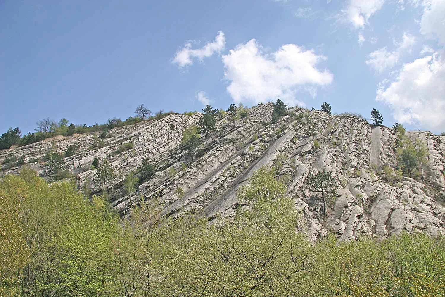
A steep, light-colored rocky hillside featuring distinct slanted geological strata, partially covered with sparse trees and bushes under a clear blue sky.
A view of the exposed geological rock strata at Radotínské skály.

Radotínské skály history and protected-area timeline

The area of today's Radotínské skály has long been shaped by human activity, including quarrying, grazing, and forestry. Past extraction left several abandoned quarries, including a former basalt quarry, and created the bare rock exposures that now form the core of the protected site.

The natural monument was officially established on 1 September 1988 by the National Committee of the City of Prague (Národní výbor hl. m. Prahy). Its designation was motivated by the outstanding geological profile recording the development of the Prague Paleozoic Basin from the upper Ordovician through the Silurian and into the lower Devonian, as well as by the associated fossil localities.

Throughout much of the 20th century, the surrounding area was heavily affected by emissions from the Lochkov cement plant, which deposited alkaline dust across the rock faces and vegetation. Beginning in the early 1990s, the installation of dust collectors and modernization of production technology significantly reduced this pollution load. This environmental improvement allowed rocky steppe and forest-steppe communities to regenerate, and the site's biodiversity gradually recovered, strengthening the long-term scientific and ecological value of the protected area.

Radotínské skály landscape and geographic character

Radotínské skály occupies the deeply incised left-hand slope of the Radotín Valley (Radotínské údolí), directly above the Radotínský potok stream as it flows toward its confluence with the Berounka River. Elevations within the site range from approximately 215 to 331 meters, producing a striking vertical relief against the surrounding lowlands of southwestern Prague.

The protected landscape is composed of steep rock walls, natural outcrops, abandoned quarry faces, and a network of ledges and shallow terraces. The most prominent feature is Šikmá skála, a tall, sloping rock wall above the Lochkov cement plant, which forms the largest of the three protected sections. A separate section is built around a former basalt quarry embedded within the woodland area known as Malý háj, while the southernmost section lies near an agricultural school between Radotín streets.

The broader landscape context is shaped by the Radotínský potok, the adjacent Berounka valley, and proximity to the Přírodní park Radotínsko – Chuchelský háj. The juxtaposition of natural cliffs, industrial heritage, peri-urban development, and the surrounding protected park landscape gives Radotínské skály a characteristic and unusually layered geography.
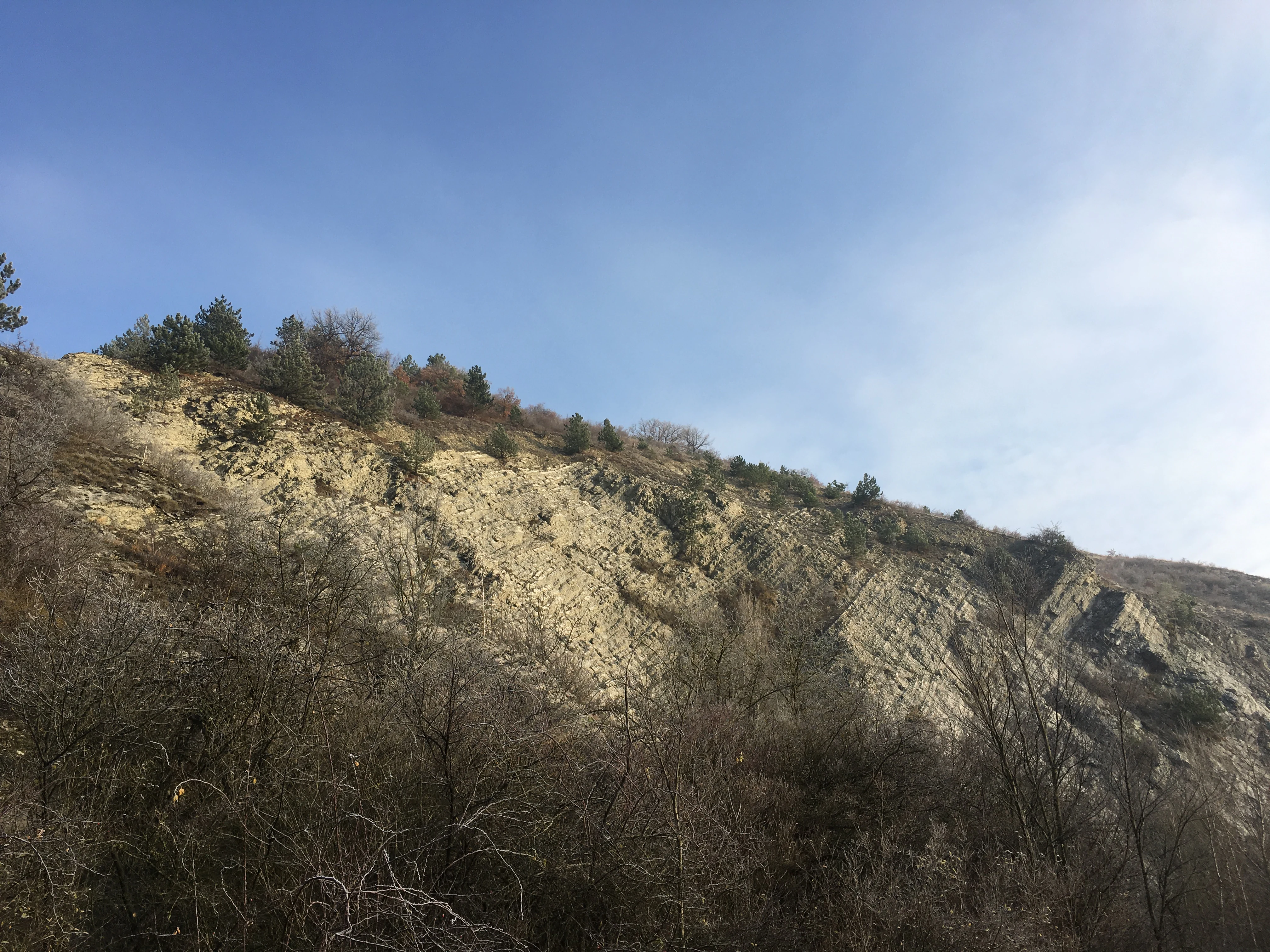
A sloped limestone rock formation with sparse vegetation and scattered trees, rising against a clear blue sky.
A view of the exposed limestone rock faces at Radotínské skály.

Radotínské skály ecosystems, habitats, and plant life

The natural character of Radotínské skály is defined by a rare combination of exposed calcareous and siliceous bedrock, warm microclimates, and a long history of open-land management. The site's vegetation ranges from relict pubescent oak woodland (doubrava) on the upper rock faces to dry rocky steppes and forest-steppe communities on the sun-exposed slopes.

Rocky steppe and forest-steppe communities are particularly significant. These open habitats support characteristic assemblages including Helianthemum canum, Carex humilis, Sesleria caerulea, Stipa capillata, Cirsium eriophorum, Teucrium botrys, Potentilla arenaria, and Bothriochloa ischaemum. Historical grazing by sheep and goats helped maintain these open conditions, and coppice management in surrounding woodlands favored broadleaf regrowth at the expense of beech, increasing overall habitat diversity.

Shadier slopes support shrubby woodland, including patches of black locust (Robinia pseudoacacia) on rocky ground, and secondary succession on former fields has produced shrubby fallow land above the rock outcrops. The varied substrate also supports rare fungi, including the mycorrhizal species Tricholoma radotinense and the earthstar Geastrum pouzarii, reflecting the unusual combination of limestone and silicate bedrock within a single protected area.
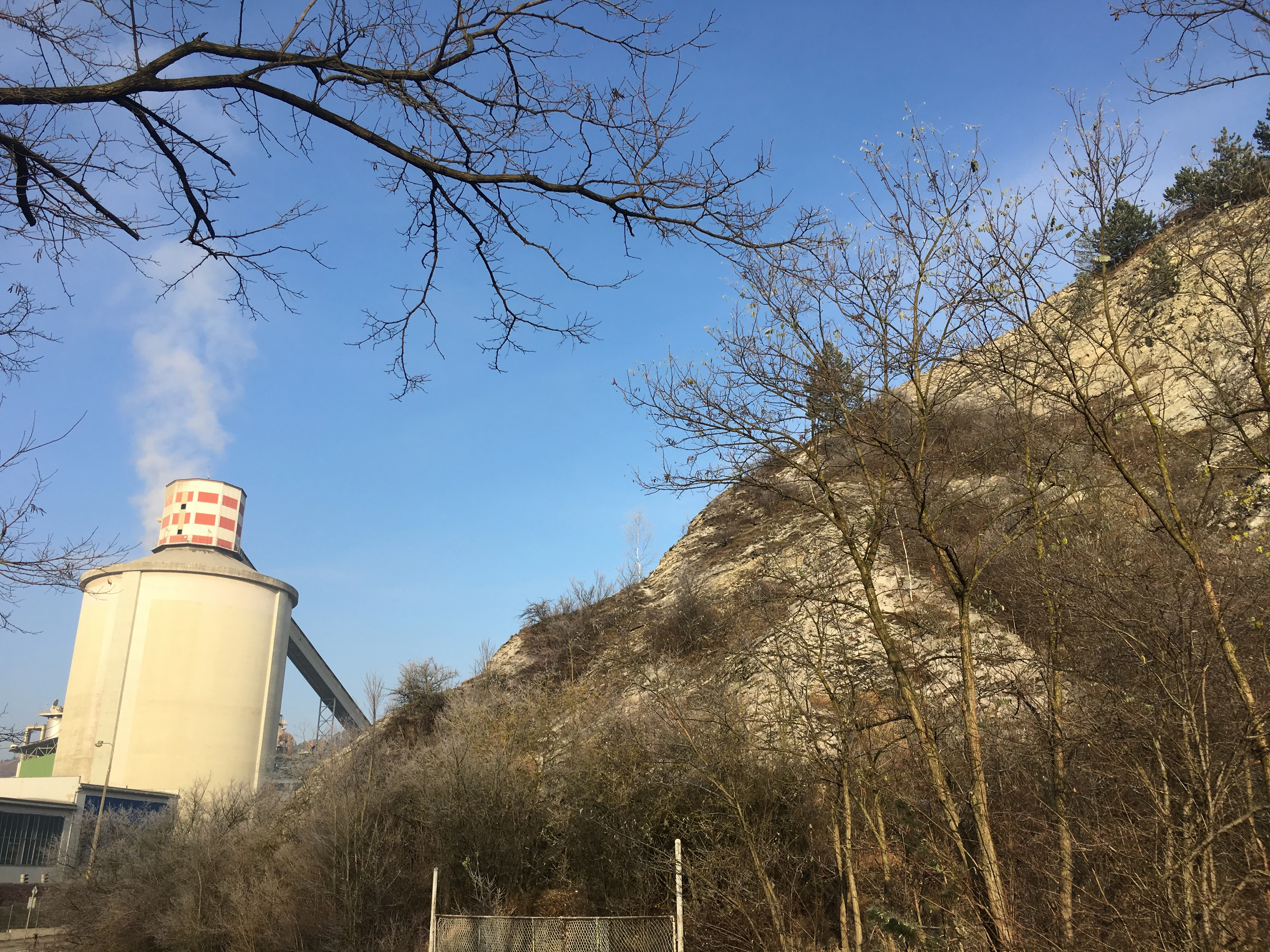
A pale, rocky cliff face rises on the right, contrasted against a large, cylindrical industrial cement silo emitting a plume of steam on the left, viewed through bare tree branches.
A view of the rock face at Radotínské skály adjacent to a cement production facility.

Radotínské skály wildlife and species highlights

Wildlife at Radotínské skály is shaped by its warm, dry rocky habitats, which support a rich community of thermophilic invertebrates. The site's recovery from cement-plant pollution, combined with ongoing conservation management, has allowed specialized steppe and forest-steppe fauna to return and flourish.

Among beetles, ground beetles such as Harpalus caspius roubali, Harpalus honestus, Ophonus rufibarbis, Microlestes maurus, and Microlestes minutulus are characteristic of the open habitats, while Cicindela campestris occurs in the lower parts of the rocks. Phytophagous beetles include Coptocephala rubicunda, Apion penetrans, and Otiorhynchus velutinus. The rare dung-beetle Sisyphus schaefferi, known for rolling dung balls, inhabits the steppe areas.

Butterfly communities include whites and blues, while rare warm-loving bees such as Hoplitis rufohirta represent the site's Hymenoptera. Reptiles are represented by Lacerta agilis and Lacerta viridis, while nesting birds include Anthus trivialis, warblers, Aegithalos caudatus, and Emberiza citrinella. Mammals recorded in the area include Erinaceus europaeus and several bat species, highlighting the site's value as a peri-urban refuge for warmth-loving wildlife.
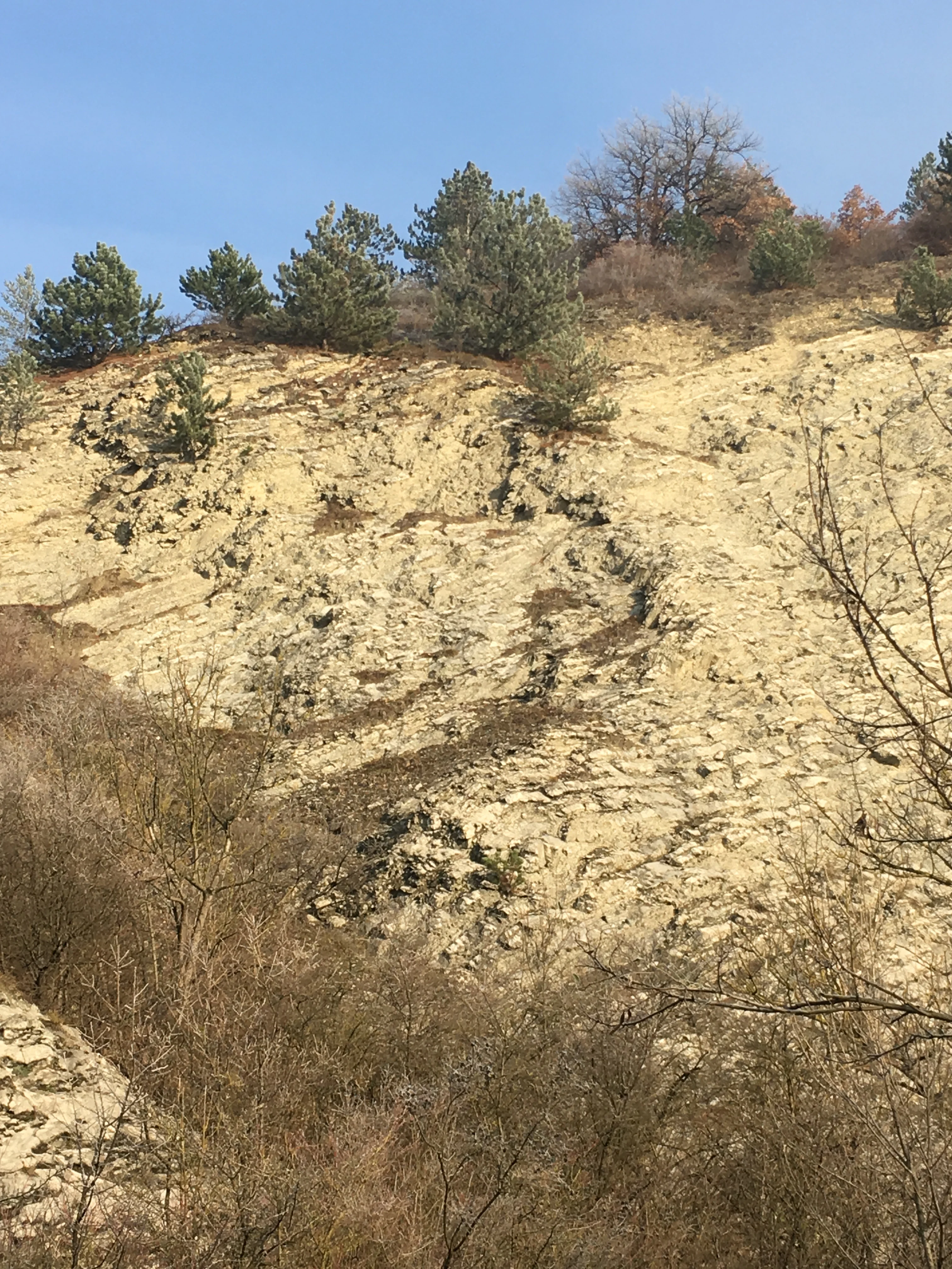
A steep, light-colored rocky hillside with patches of dry vegetation and small evergreen trees, under a clear blue sky.
The exposed limestone rock formations and rocky slopes of Radotínské skály.

Radotínské skály conservation status and protection priorities

The conservation significance of Radotínské skály rests on two complementary pillars: the protection of an irreplaceable geological and paleontological reference section, and the preservation of rare rocky-steppe and forest-steppe habitats within a heavily modified peri-urban landscape.

Designated as a natural monument in 1988, the site safeguards a near-continuous Paleozoic profile that documents the development of the Prague Basin during the late Ordovician, Silurian, and early Devonian, including the globally important Silurian-Devonian boundary interval. The exposures, especially the Antipleurová rokle section with its Antipleura bohemica bivalve assemblage, are internationally recognized for biostratigraphy and micro-biostratigraphy, making the site essential for ongoing paleontological research.

On the ecological side, conservation management is focused on maintaining existing rocky steppe and forest-steppe habitats, restoring lost patches, controlling invasive black locust, and gradually increasing the proportion of natural tree species with diverse age structure. Regular mowing, shrub reduction, and grazing support open conditions. Active threats include residual industrial influence from the adjacent cement plant, increasing visitor pressure from nearby Prague, and erosion caused by riders from nearby stables, all of which require continued active management.

Radotínské skály cultural meaning and human context

Radotínské skály lies within Radotín, a historic Prague district whose identity has long been shaped by the cement industry, most visibly the Lochkov cement plant adjacent to the protected rocks. This industrial heritage is integral to the site's modern story, as decades of cement dust influenced both the landscape and its ecological recovery once emissions were reduced.

The surrounding landscape also features a rich network of hiking trails connecting the site to cultural landmarks in the Berounka valley, including Karlštejn, Tetín, and Svatý Jan pod Skalou, embedding the natural monument within a broader regional tradition of geological and cultural exploration in central Bohemia.

Top sights and standout views in Radotínské skály

What makes Radotínské skály notable is the unusual concentration of geological, paleontological, and ecological value within a single protected area on the edge of Prague. Its near-continuous profile through the uppermost Ordovician, Silurian, and lower Devonian includes one of the best Silurian-Devonian boundary sections in Bohemia and globally important fossil-bearing strata.

At the same time, the exposed rocks, quarries, and warm slopes support relict oak woodland and rocky steppe habitats that harbor rare thermophilic beetles, butterflies, solitary bees, reptiles, and steppe plants. The site's location within a major European capital, alongside an active cement plant and a protected landscape park, makes it a striking example of how geological heritage and steppe biodiversity can be conserved even in heavily modified peri-urban environments.

Best time to visit Radotínské skály

Radotínské skály can be visited year-round, but spring and early summer are particularly rewarding for observing the rocky steppe vegetation in bloom, when species such as Helianthemum canum and Anthericum liliago are most visible. Late spring and early summer also offer the best conditions for spotting thermophilic invertebrates and reptiles active on warm rock surfaces.

Autumn brings softer light on the rock faces and a quieter atmosphere, which is favorable for geological observation and photography along the exposures and former quarries. Winters tend to be mild within the city's microclimate, but bare deciduous vegetation and exposed rock make the geological structures easier to read at this time. Visitors should expect to combine the visit with awareness of the nearby industrial areas and respect seasonal grazing or conservation management on the slopes.

Monthly climate preview

Long-term monthly averages and temperature ranges for this protected location

Radotínské skály Climate Normals: Annual Temperature and Precipitation Profiles

Historical climate records for Radotínské skály capture measured monthly temperature swings from subfreezing winter lows to warm summer maximums alongside steady precipitation rates. Reviewing these representative coordinate measurements provides clear baseline context for annual weather patterns across the protected landscape.
Annual mean9 °C
-2 °C20 °C
Jan-2°
Feb-1°
Mar
Apr
May13°
Jun17°
Jul20°
Aug19°
Sep14°
Oct
Nov
Dec-1°
Warmest month
July

19.7 °C

Coolest month
January

-2.2 °C

Wettest month
June

2.6 mm/day

Driest month
February

1.1 mm/day

Park location guide

Geography guide, regional context, and park location map for Radotínské skály

Radotínské skály park geography, regions, and map view in Czechia

Understand where Radotínské skály sits in Czechia through a broader geographic reading of the surrounding landscape, nearby location context, and its mapped position within the national park landscape.

How Radotínské skály fits into Czechia

Czech Republic is a landlocked Central European country with a population of approximately 10.9 million people. The nation was established as an independent state on January 1, 1993, following the dissolution of Czechoslovakia. Its capital and largest city is Prague, with other major urban centers including Brno, Ostrava, Plzeň, and Liberec.

Wider geography shaping Radotínské skály in Czechia

The Czech Republic is a landlocked country in Central Europe. It is bordered by Germany to the west, Austria to the south, Poland to the northeast, and Slovakia to the southeast. The landscape is predominantly hilly, with the territory covering 78,871 square kilometers.

Map view of Radotínské skály

Use this park location map to pinpoint Radotínské skály in Czechia, understand its exact geographic position, and read its mapped placement within the surrounding landscape more clearly.

Pigeon | © OpenStreetMap contributors

Location context for Radotínské skály

Prague

Visual reference guide to exposed rock faces, geological outcrops, and rocky steppe habitats

Radotínské skály Photos and Landscape Scenery

Visual documentation captures the dramatic vertical relief, steep limestone walls, and unique protected-area environment of Radotínské skály. Photographic records reveal the distinctive terrain and specialized habitats that define this protected natural monument near Prague.

A steep, light-colored rocky hillside featuring distinct slanted geological strata, partially covered with sparse trees and bushes under a clear blue sky.

A wide panoramic photograph showing a steep, light-colored rocky cliff face covered with sparse trees and brush in the foreground.

A sloped limestone rock formation with sparse vegetation and scattered trees, rising against a clear blue sky.

A pale, rocky cliff face rises on the right, contrasted against a large, cylindrical industrial cement silo emitting a plume of steam on the left, viewed through bare tree branches.

A steep, light-colored rocky hillside with patches of dry vegetation and small evergreen trees, under a clear blue sky.

Park atlas

Compare surrounding regional geography and connected protected areas near Prague

Explore Other Parks Near Radotínské Skály and Related Protected Landscapes

Continue browsing other parks near Radotínské skály to examine similar geological formations, rocky steppes, and peri-urban conservation zones. Expanding the geographic comparison reveals broader protected landscapes and regional park networks across the surrounding territory.
Natural monumentPrague
About 3.2 km away#1 closest

Northwest

Zmrzlík Natural Monument: Geological Profile and Protected Landscape Map of Prague

Silurian stratotype sites and calcareous grassland ecosystems

Zmrzlík is a protected natural monument in Prague, defined by its rich Silurian geological sequences and fossil-bearing limestone deposits. The site offers a clear view into the Kopanina Formation, featuring distinct basaltic volcanic remains and rare xerothermic vegetation. This map-based resource details the terrain and ecological mosaic of the area, ranging from rocky ridges to the valleys of the Mlýnský potok.

Area
0.164 km²
Established
1988
IUCN
IV
Relief
Upland
Nature reservePraha 5
About 4.9 km away#2 closest

North

Prokopské údolí Nature Reserve: Geological Mapping and Protected Area Discovery

A limestone karst landscape situated within the Praha 5 district

Prokopské údolí is an essential protected nature reserve in Praha 5, featuring a deep limestone valley that serves as a globally significant site for Paleozoic fossils and karst geography. This protected landscape encompasses a range of habitats including rock steppes, thermophilic woodlands, and volcanic outcrops, providing a unique look at urban-adjacent nature conservation and historical limestone quarrying within the Czech Republic.

Area
1.71 km²
Established
1978
IUCN
III
Relief
Upland
Nature reservePrague
About 6.9 km away#3 closest

East

V hrobech Nature Reserve: A Protected Botanical Island within the Urban Landscape of Prague

Rare dry-grassland habitats in the Kamýk district

V hrobech is a designated nature reserve in Prague featuring 1.3 hectares of southeast-facing slopes and species-rich grassland. This site is home to rare thermophilic plants and represents an important example of intensive conservation management in an urban environment. Its protected boundaries connect with local forest fragments to maintain ecological value amidst the residential developments of Lhotka and Libuš.

Area
0.013 km²
Established
1988
IUCN
IV
Relief
Lowland
Natural monumentPrague
About 7.8 km away#4 closest

North

Vidoule Natural Monument: Geological Profile and Protected Landscape Context in Prague

A table mountain remnant with exposed Cretaceous sandstone formations.

Vidoule stands as a significant natural monument in western Prague, defined by its flat-topped table mountain geometry and horizontal Cretaceous strata. The site offers a unique perspective on the regional geology of the Prague Plateau, where protected slopes guard rare dry grassland habitats and fossil-rich layers against a backdrop of dense urban development.

Area
0.087 km²
Established
1988
IUCN
III
Relief
Upland
A soft watercolor painting of a green landscape featuring a small body of water, rolling hills, and trees, painted in a minimalist style on a white background.
Protected landscapePrague
About 13 km away#5 closest

Northeast

Hostivař-Záběhlice Nature Park: Protected Landscape and Mapped Prague Geography

River valleys and reservoir terrain within the capital city.

Hostivař-Záběhlice Nature Park represents a vital natural zone in Prague, characterized by the mature forests and meandering river paths along the Botič stream. This record highlights the park's geographic composition, including its reservoirs, lowland forest patches, and its function as a preserved natural corridor within the city.

Area
4.23 km²
Established
1990
Relief
Lowland
Climate
Temperate
Natural monumentPrague
About 13 km away#6 closest

North

Vizerka Natural Monument: Mapped Protected Landscapes and Rocky Terrain in Prague

A rare xerothermic steppe refuge on the edge of the Šárka Valley

Vizerka represents a compact yet significant natural monument located on the rocky slopes of the Šárecké údolí in Prague. Featuring exposed Proterozoic shale and shallow soils, this protected site serves as a vital island of thermophilic grasslands and shrubby terrain. It offers a fascinating look at relict warm-loving habitats and rare species survival within the dense geographical context of a European capital city.

Area
0.031 km²
Established
1988
IUCN
IV
Relief
Upland
A horizontal watercolor illustration showing a soft, dreamy landscape with rolling green hills, light purple and yellow tones, a winding path or stream, and a lone bare tree in the foreground.
Protected landscapePraha
About 13 km away#7 closest

North

Přírodní park Šárka-Lysolaje: Protected Landscape Mapping and Geographic Identity in Praha

A dense mosaic of stream valleys and protected natural monuments near the heart of Praha

Examine the detailed geography of Přírodní park Šárka-Lysolaje, an extensive protected landscape in Praha that functions as a critical green corridor. Its terrain, defined by deeply incised stream valleys and steep forested slopes, hosts a unique concentration of smaller nature reserves and monuments, creating a coherent ecological framework directly adjacent to the urban metropolitan environment.

Area
10.05 km²
Established
1990
Climate
Temperate
Scope
Terrestrial
A soft, minimalist watercolor painting showing a green treeline against a pale pink and white background, suggestive of wetlands or ponds.
Natural monumentPrague
About 14 km away#8 closest

East

Milíčovský les a rybníky: Protected Landscape and Wetland Map in Prague, Czech Republic

Natural monument geography and forest-wetland habitat atlas

Milíčovský les a rybníky represents a core natural monument in southern Prague, featuring a mature deciduous forest integrated with a managed system of ponds. This protected area serves as a critical refuge for rare wetland and woodland species. Use the mapping tools to trace the terrain, from the dense oak-hornbeam canopy to the extensive reedbeds and aquatic environments that define this unique urban-edge landscape.

Area
1.047 km²
Established
1991
IUCN
III
Relief
Upland

Common questions about visiting, size, designation, and location context for Radotínské skály

Radotínské skály FAQs for park facts, access, geography, and protected area context

Find quick answers about Radotínské skály, including protected-area facts, park geography, trail and visitor context, and how the park fits into its surrounding country and regional landscape.
MoriAtlas Explorer

Continue Your Protected Areas Search Across the Global Atlas

Deepen your exploration by continuing the structured search for national parks and protected areas worldwide. Utilize the comprehensive filtering capabilities to compare different conservation landscapes and refine your understanding of global park geography. Discover more about the distribution and characteristics of protected natural areas.

Global natural geography