

Mori Atlas logo
Marine protected areaRani Jhansi Marine National Park

Mapping the protected marine boundaries and regional geography of this vital Indian conservation area.

Rani Jhansi Marine National Park: India's Premier Marine Protected Area and Geographic Landscape

Rani Jhansi Marine National Park represents a significant marine protected area situated within the diverse geography of India. As a protected landscape, it offers critical insights into the country's coastal conservation efforts and the mapping of its marine environments. Understanding this park's boundaries and its role in the broader South Asian maritime context is essential for exploring India's protected lands through an atlas lens.

Marine National ParkCoral ReefsMangrove ForestsAndaman and Nicobar IslandsIsland ConservationRitchie's Archipelago

Rani Jhansi Marine National Park

Marine protected area

Park overview

Structured park overview, official facts, and landscape profile for Rani Jhansi Marine National Park

Rani Jhansi Marine National Park park facts, protected area profile, and essential visitor context

Review the core facts for Rani Jhansi Marine National Park, including designation, size, terrain, visitor scale, habitats, and operating context in one park-focused overview.

About Rani Jhansi Marine National Park

Rani Jhansi Marine National Park represents a significant marine protected area within the Union Territory of the Andaman and Nicobar Islands, positioned in the Bay of Bengal off the eastern coast of India. The park occupies a substantial portion of Ritchie's Archipelago, a cluster of islands known for their scenic beauty and rich marine biodiversity. Established in 1996, the park was created with the dual purpose of preserving the region's unique marine ecosystems and honoring the historical legacy of Rani Lakshmibai, the iconic queen of Jhansi. The park's 256-square-kilometer expanse encompasses both the aquatic environments surrounding the islands and the terrestrial mangrove areas that fringe the coastlines. The significance of Rani Jhansi Marine National Park extends beyond its ecological value to encompass the broader conservation priorities of India in its island territories. The Andaman and Nicobar Islands represent one of India's most ecologically diverse regions, with the park serving as a protected stronghold for marine habitats that include coral reef communities and mangrove forest systems. These habitats support a range of species and contribute to the overall health of the Bay of Bengal's coastal ecosystems. The park's location in Ritchie's Archipelago places it within a region that is both geographically distinctive and environmentally sensitive, requiring careful management to balance ecological preservation with appropriate access.

Quick facts and research context for Rani Jhansi Marine National Park

Rani Jhansi Marine National Park occupies 256 square kilometers in the Ritchie's Archipelago of the Andaman and Nicobar Islands, established in 1996. The park is located about 30 kilometers from Port Blair, the territorial capital, and lies within the Bay of Bengal. It was designated under IUCN Category II as a national park, reflecting its primary conservation mandate. The park protects coral reef formations and mangrove forest habitats that define the marine environment of these islands. The park bears the name of Rani Lakshmibai of Jhansi, the 19th-century queen celebrated for her role in the Indian Rebellion of 1857.

Protection and recognition

Documented marine conservation framework and official environmental status

Rani Jhansi Marine National Park Protection Status and Designation

Geographic records outline the official marine designation status and documented boundaries established for Rani Jhansi Marine National Park. Detail profiles compile the legal conservation framework, protection scope, and available international management records to support structured regional analysis.

Protection details

Protection scope
Marine
Park context

Deeper park guide and search-rich context for Rani Jhansi Marine National Park

Rani Jhansi Marine National Park history, landscape, wildlife, and travel context

Explore Rani Jhansi Marine National Park through its history, landscape character, ecosystems, wildlife, conservation priorities, cultural context, and seasonal travel timing in a structured park guide built for atlas discovery and search intent.

Why Rani Jhansi Marine National Park stands out

Rani Jhansi Marine National Park is particularly notable for its combination of coral reef and mangrove forest ecosystems that thrive in the clear tropical waters of Ritchie's Archipelago. The park is distinguished by the presence of a fruit-eating bat species that inhabits the area and plays a significant ecological role within the park's ecosystem. This bat contributes to the broader ecological function of the marine environment by pollinating plants and dispersing seeds, making it the biggest attraction within the park. The convergence of terrestrial and marine habitats creates a distinctive conservation area where mangrove forests border coral reef systems, supporting interconnected ecological processes.

Rani Jhansi Marine National Park history and protected-area timeline

Rani Jhansi Marine National Park was established in 1996 as part of India's expanding network of marine protected areas. The creation of the park reflected a growing recognition of the ecological importance of the Andaman and Nicobar Islands' marine environments and the need for dedicated conservation areas to protect these habitats. The park was named after Rani Lakshmibai of Jhansi, the celebrated queen who became an emblem of resistance during the Indian Rebellion of 1857. Naming the park after this historical figure connected the protected area to a significant narrative in Indian history, reflecting the practice of honoring important figures through geographic designations. The establishment of the park in Ritchie's Archipelago represented a commitment to preserving the unique island ecosystems that characterize this portion of the Bay of Bengal. As a Category II protected area under the IUCN classification system, the national park designation provides a framework for conservation management that emphasizes the protection of natural ecosystems while allowing for some controlled uses compatible with conservation objectives.

Rani Jhansi Marine National Park landscape and geographic character

Rani Jhansi Marine National Park is characterized by the aquatic and coastal landscapes of Ritchie's Archipelago, a cluster of islands scattered across the Bay of Bengal. The park's terrain encompasses the marine environments surrounding these islands, including the shallow coastal waters where coral reef formations develop. The mangrove forests that fringe the island coastlines represent a distinctive landscape feature, where tidal influence creates a transition zone between terrestrial and marine ecosystems. The waters of Ritchie's Archipelago are typically clear and tropical, providing conditions suitable for the development of coral reef communities. The islands themselves are relatively low-lying, with coastal areas characterized by the presence of mangrove vegetation that thrives in the saline waters of tidal zones. The overall landscape of the park is defined by the interplay between the islands' terrestrial surfaces and the extensive marine environment that surrounds them, creating a maritime protected area with both underwater and coastal landscapes.

Rani Jhansi Marine National Park ecosystems, habitats, and plant life

The natural environment of Rani Jhansi Marine National Park is defined by the convergence of coral reef ecosystems and mangrove forest habitats that characterize the marine environments of the Andaman and Nicobar Islands. Coral reef systems develop in the clear, warm waters surrounding the islands, supporting diverse marine communities adapted to reef environments. Mangrove forests occupy the coastal margins where tidal fluctuations create conditions suitable for these salt-tolerant tree species. The combination of these two habitat types creates a complex ecological system where terrestrial and marine processes interact. The park's location in Ritchie's Archipelago places it within a region where tropical marine biodiversity is relatively high, supporting communities of reef organisms, fish species, and other marine life that depend on healthy coral and mangrove habitats. The ecological interconnectedness between coral reefs and mangrove forests is significant, as mangroves provide nursery habitat for many reef species and help maintain water quality that supports coral health.

Rani Jhansi Marine National Park wildlife and species highlights

The wildlife of Rani Jhansi Marine National Park is centered on its marine ecosystems, where coral reef communities and mangrove habitats support diverse assemblages of species. Among the notable inhabitants is a fruit-eating bat species that represents the park's most prominent attraction. This bat plays a fundamental ecological role within the park's environment through its pollination activities and seed dispersal functions. By visiting flowering plants and consuming fruits, the fruit-eating bat facilitates pollination and contributes to the propagation of plant species throughout the island environment. The bat's activities connect the park's terrestrial and marine ecosystems in meaningful ways, as seed dispersal can influence forest composition and regeneration. The coral reef environments support fish species and invertebrate communities that are characteristic of tropical reef systems, while the mangrove habitats provide refuge for various species that utilize these productive coastal forests.

Rani Jhansi Marine National Park conservation status and protection priorities

Rani Jhansi Marine National Park serves as an important conservation area within India's system of protected territories, with its marine focus addressing the need to preserve the ecological value of the Andaman and Nicobar Islands' coastal and oceanic environments. The national park designation provides a framework for protecting the coral reef and mangrove habitats that represent significant ecological assets. The presence of the fruit-eating bat highlights the park's conservation relevance, as this species fulfills ecological functions that contribute to ecosystem health and resilience. Protecting the bat's habitat supports broader ecological processes including plant pollination and seed dispersal that maintain forest communities. The park's designation under IUCN Category II reflects its primary objective of conserving natural ecosystems while recognizing its role within the broader network of protected areas in the Bay of Bengal region. Conservation of this marine environment also contributes to maintaining the ecological character of Ritchie's Archipelago and supports the biodiversity objectives of the Andaman and Nicobar Islands territory.

Rani Jhansi Marine National Park cultural meaning and human context

Rani Jhansi Marine National Park carries historical significance through its naming after Rani Lakshmibai, the queen of Jhansi who became one of the most celebrated figures of the Indian Rebellion of 1857. Born in 1828 and dying in 1858, Rani Lakshmibai led resistance forces against British rule and became an emblem of defiance and courage in Indian historical memory. The decision to name this marine protected area after her connects the ecological landscape of the Andaman and Nicobar Islands to a major figure from mainland Indian history, reflecting the practice of commemorating important historical personalities through geographic designations. The park exists within the territory of the Andaman and Nicobar Islands, which have their own complex history of human habitation and colonial administration. While the park itself focuses on marine conservation, the broader cultural context of the islands includes indigenous communities and historical periods of colonial use that have shaped the region's character.

Top sights and standout views in Rani Jhansi Marine National Park

Rani Jhansi Marine National Park protects 256 square kilometers of marine environments in Ritchie's Archipelago, featuring both coral reef systems and mangrove forests. The park is distinguished by its fruit-eating bat, an ecologically significant species that contributes to pollination and seed dispersal throughout the island environment. Located approximately 30 kilometers from Port Blair, the park offers access to tropical marine ecosystems within the Andaman and Nicobar Islands. The park's designation as an IUCN Category II protected area reflects its conservation mandate for preserving natural ecosystems. Named after Rani Lakshmibai of Jhansi, the park connects ecological preservation to historical commemoration. The combination of coral reefs and mangroves creates interconnected habitats that support marine biodiversity and ecological processes.

Best time to visit Rani Jhansi Marine National Park

The Andaman and Nicobar Islands, including the waters of Ritchie's Archipelago where Rani Jhansi Marine National Park is located, experience a tropical climate with distinct wet and dry seasons. The optimal period for visiting the park generally falls during the cooler, drier months from October through April, when weather conditions are more favorable for marine activities and island exploration. During this season, sea conditions tend to be calmer and visibility underwater is typically better, supporting better conditions for observing coral reef environments. The monsoon season from May through September brings increased rainfall and rougher sea conditions that may affect access and visibility. The tropical setting means that temperature variations are minimal throughout the year, though the dry season offers more comfortable conditions for visitors.
Monthly climate preview

Long term average temperature and monthly precipitation patterns across representative coordinates

Rani Jhansi Marine National Park Climate Normals and Weather by Month

Representative coordinates record sustained thermal averages alongside distinct seasonal shifts in monthly precipitation volumes. Deeper examination of the complete twelve month profile reveals detailed temperature ranges and precipitation normals across the protected area.
Annual mean28 °C
27 °C29 °C
Jan27°
Feb27°
Mar28°
Apr29°
May29°
Jun28°
Jul28°
Aug28°
Sep28°
Oct28°
Nov28°
Dec27°
Warmest month
April

29.2 °C

Coolest month
January

26.7 °C

Wettest month
September

13.2 mm/day

Driest month
February

0.4 mm/day

Park location guide

Geography guide, regional context, and park location map for Rani Jhansi Marine National Park

Rani Jhansi Marine National Park park geography, regions, and map view in India

Understand where Rani Jhansi Marine National Park sits in India through a broader geographic reading of the surrounding landscape, nearby location context, and its mapped position within the national park landscape.

How Rani Jhansi Marine National Park fits into India

India is a South Asian country bordered by the Indian Ocean, Arabian Sea, and Bay of Bengal. It shares land borders with Pakistan, China, Nepal, Bhutan, Bangladesh, and Myanmar. The country has a population of over 1.4 billion people and operates as a federal parliamentary republic with its capital in New Delhi.

Wider geography shaping Rani Jhansi Marine National Park in India

India occupies the Indian subcontinent in South Asia, bordered by the Arabian Sea to the southwest, the Bay of Bengal to the southeast, and the Indian Ocean to the south. It shares land borders with Pakistan to the west, China, Nepal, and Bhutan to the north, and Bangladesh and Myanmar to the east. The territory also includes the Andaman and Nicobar Islands in the Indian Ocean.

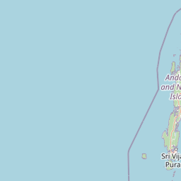
Map view of Rani Jhansi Marine National Park

Use this park location map to pinpoint Rani Jhansi Marine National Park in India, understand its exact geographic position, and read its mapped placement within the surrounding landscape more clearly.

Pigeon | © OpenStreetMap contributors

Location context for Rani Jhansi Marine National Park

Andaman and Nicobar Islands
Park atlas

Map the protected marine landscapes and connected island conservation areas throughout the Andaman and Nicobar region.

Compare National Parks and Protected Areas Surrounding Rani Jhansi Marine National Park

After exploring Rani Jhansi Marine National Park, delve into a curated atlas of nearby national parks and protected areas, focusing on marine, coastal, and island conservation landscapes in the Andaman and Nicobar Islands. This expanded view allows you to compare diverse ecosystems, understand regional protected-area geography, and trace the spread of unique conservation territories across the Bay of Bengal.
National parkAndaman and Nicobar Islands
About 6.7 km away#1 closest

Southeast

Mount Harriet National Park: National Park Mapping and Protected Landscape Identity

Explore its endemic biodiversity and mountain forest terrain.

Mount Harriet National Park provides a deep dive into a unique protected landscape, offering detailed insights into its geography, terrain, and ecological significance within the Andaman and Nicobar Islands. As a national park, it showcases a remarkable combination of mountainous forest ecosystems and coastal environments, serving as a vital habitat for numerous endemic species. Understanding its mapped boundaries and regional geographic context reveals why this protected area is a key point of interest for atlas-based natural landscape exploration.

Area
46.62 km²
Established
1979
IUCN
II
Relief
Mountain
Wildlife reserveAndaman and Nicobar Islands
About 20 km away#2 closest

North

Defence Island Wildlife Sanctuary: Protected Geography and Island Ecosystems in the Andaman Archipelago

A remote wildlife reserve within the South Andaman district

Defence Island Wildlife Sanctuary represents a key protected landform within the Andaman and Nicobar union territory. Characterized by its coastal littoral habitats and dense tropical interior, this uninhabited island reserve serves as a significant site for regional biodiversity and landscape conservation efforts in the Bay of Bengal.

Area
5.04 km²
Water
Water-dominated
Season
Year-round
National parkIndia
About 29 km away#3 closest

South

Mahatma Gandhi Marine National Park: India National Park Protected Landscape and Geography

Explore mapped boundaries and regional geographic context.

Gain a detailed understanding of Mahatma Gandhi Marine National Park, a designated national park in India. This entry focuses on its protected area status, the mapped extent of its natural landscape, and its significance within India's diverse geography. Discover the park's spatial context and contribution to the nation's protected lands through an atlas-focused lens, providing essential geographic details for informed exploration.

Area
281.5 km²
Established
1983
IUCN
II
Relief
Lowland
National parkAndaman and Nicobar Islands
About 62 km away#4 closest

Northeast

South Button Island National Park: Mapped Boundaries and Regional Protected Landscape

Key National Park in the Andaman and Nicobar Islands

South Button Island National Park is a protected natural area offering critical insight into the geography of the Andaman and Nicobar Islands. This detailed view focuses on its mapped boundaries and its significance as a national park within this Indian archipelago. Understanding its position within the regional geography provides essential context for exploring protected lands and natural landscapes across the Andaman and Nicobar Islands.

Area
5 km²
Relief
Lowland
Climate
Tropical
Access
Moderate access
National parkAndaman and Nicobar
About 67 km away#5 closest

Northeast

Middle Button Island National Park: National Park within Andaman and Nicobar's Geography

Explore protected landscape context and mapped park boundaries.

Middle Button Island National Park represents a significant protected natural landscape, offering users a focused entry point for geographic discovery. As a designated national park, it contributes distinct mapped boundaries and terrain characteristics to the Andaman and Nicobar region's atlas data. Understanding its specific identity helps contextualize the broader protected-area network and regional geography. This page details the park's role as a conserved territory, vital for those seeking structured landscape and geography information.

Area
64 km²
Established
1979
Relief
Lowland
Climate
Tropical
National parkAndaman and Nicobar Islands
About 73 km away#6 closest

Northeast

North Button Island National Park: Protected Landscape and Mapped Geographic Identity

Explore the mapped boundaries and regional natural terrain.

Gain a clear understanding of North Button Island National Park as a distinct protected landscape within the Andaman and Nicobar Islands region. This entry offers detailed geographic context, focusing on the park's mapped boundaries and its role within the archipelago's natural terrain. It serves as a foundational element for understanding this Indian National Park's place in a broader atlas of conservation areas.

Area
114 km²
Established
1979
Wildlife reserveAndaman and Nicobar Islands
About 83 km away#7 closest

North

Flat Island Wildlife Sanctuary: Protected Island Geography in the Andaman and Nicobar Islands

Coastal wildlife reserve and isolated island terrain

Flat Island Wildlife Sanctuary stands as a distinct, low lying protected area within the Andaman and Nicobar Islands. Its compact oval shape and shoreline focused landscape provide a clear example of the archipelago's small scale, uninhabited marine reserves. This protected island serves as a vital geographic marker for those mapping the diverse coastal habitats found across the Bay of Bengal.

Area
2.48 km²
Relief
Lowland
Climate
Tropical
Access
Remote access
Wildlife reserveAndaman and Nicobar Islands
About 108 km away#8 closest

North

Cuthbert Bay Wildlife Sanctuary: Coastal Habitat and Sea Turtle Nesting Ground

Eastern Middle Andaman protected coastal geography

Cuthbert Bay Wildlife Sanctuary covers 5.8 square kilometres of critical coastal terrain along the eastern Middle Andaman coastline. Renowned for its concentration of sea turtle nesting beaches, the reserve supports diverse coastal ecosystems ranging from open sand to inland forest patches. It serves as a compact but vital ecological anchor within the broader landscape of the Andaman and Nicobar Islands.

Area
5.8 km²
Established
1997
IUCN
IV
Scope
Terrestrial

Common questions about visiting, size, designation, and location context for Rani Jhansi Marine National Park

Rani Jhansi Marine National Park FAQs for park facts, access, geography, and protected area context

Find quick answers about Rani Jhansi Marine National Park, including protected-area facts, park geography, trail and visitor context, and how the park fits into its surrounding country and regional landscape.
MoriAtlas Explorer

Continue Your Protected Areas Search Across the Global Atlas

Deepen your exploration by continuing the structured search for national parks and protected areas worldwide. Utilize the comprehensive filtering capabilities to compare different conservation landscapes and refine your understanding of global park geography. Discover more about the distribution and characteristics of protected natural areas.

Global natural geography