Mori Atlas logo
Nature reserveRéserve naturelle régionale de la forêt de Mequillet « Le Hardtwald »

A detailed geographic study of dry forest and steppe clearings on the Alsace Rhine terrace

Réserve naturelle régionale de la forêt de Mequillet Le Hardtwald Protected Landscape and Map

The Réserve naturelle régionale de la forêt de Mequillet Le Hardtwald represents a critical protected area in the Grand Est region, defined by its rare continental botanical assemblages and dry woodland character. This structured geographic entry traces the park boundaries across the coarse alluvium of the Rhine plain, illustrating how elevated terraces support ecosystems that diverge from typical lowland forests. Users can examine the physical terrain, including the steppe-like clearings and mature broadleaf habitats that characterize this protected nature reserve.

dry foreststeppe clearingsAlsace plainRhine terracebroadleaf woodlandcontinental flora

Réserve naturelle régionale de la forêt de Mequillet « Le Hardtwald »

Nature reserve

Park overview

Structured park overview, official facts, and landscape profile for Mequillet Forest Regional Nature Reserve (Le Hardtwald)

Mequillet Forest Regional Nature Reserve (Le Hardtwald) park facts, protected area profile, and essential visitor context

Review the core facts for Mequillet Forest Regional Nature Reserve (Le Hardtwald), including designation, size, terrain, visitor scale, habitats, and operating context in one park-focused overview.

About Mequillet Forest Regional Nature Reserve (Le Hardtwald)

Mequillet Forest Regional Nature Reserve lies in the southern Alsace plain, just a few kilometers east of Colmar and close to the German border, on the territory of the commune of Heiteren. Its compact form, stretching roughly 3 km north to south and about 1 km across, places it firmly within the open agricultural landscape of the Upper Rhine plain, yet the character of the woodland itself feels distinctly inland and continental rather than typically Alsatian.

The reserve's defining feature is its dry forest character, a consequence of its position on an elevated terrace of old Rhine alluvium made up of coarse gravels and conglomerates. These free-draining substrates, combined with relatively modest rainfall and a steadily deepening groundwater table, create soils that are much drier than those of the surrounding plain. The result is a woodland dominated by broadleaf species adapted to dryness and warmth, interspersed with open clearings where thin soils and exposure have generated small patches of steppe-like vegetation. Around 23 hectares of these steppe-like clearings form the second pillar of the site's ecological value.

Beyond its botanical interest, the reserve hosts an unusually rich entomological community, especially saproxylic insects tied to mature broadleaf trees. The combination of old woodland trees, deadwood, and warm dry clearings provides conditions for species that are rare or declining elsewhere in the region. Cultural and historical context adds another layer: the forest was formerly a private estate of the Mequillet family and was later transferred to the Protestant consistory of Colmar, which helps explain its long continuity as a wooded landscape.

Today, Le Hardtwald serves as a working example of how a small protected area can preserve dry lowland and steppe-like habitats that are otherwise rare in the Rhine plain. Its trails, botanical path in the northern section, and limited allowances for cyclists and riders make it accessible for low-impact outdoor use, while its conservation mission centers on maintaining both the dry forest structure and the open steppe clearings.

Quick facts and research context for Mequillet Forest Regional Nature Reserve (Le Hardtwald)

The reserve is a French regional nature reserve (Réserve naturelle régionale) classified on 16 March 2012 and managed by the Conservatoire des Sites Alsaciens. It lies in the Haut-Rhin department of the Grand Est region, on the commune of Heiteren, southwest of Colmar.

The protected area covers around 249 hectares of forest and dry habitat on an elevated Rhine terrace close to the German border. A separate, older status as a protected forest (forêt de protection) covers a 66.7 hectare portion of the same woodland, granted by decree in 1996. The reserve's ecology combines dry oak-rich forest with around 23 hectares of steppe-like clearings.

Protection and recognition

Documented terrestrial protection history and designation records

Réserve naturelle régionale de la forêt de Mequillet Le Hardtwald Protection Status

Terrestrial protected area records establish the official designation history and management scope established in 2012. Systematic database metrics trace verified conservation boundaries without assuming external recognition programs.

Protection details

Protection scope
Terrestrial
Designated year
2012
Transboundary protection
No
WDPA ID
555559621
Park context

Deeper park guide and search-rich context for Mequillet Forest Regional Nature Reserve (Le Hardtwald)

Mequillet Forest Regional Nature Reserve (Le Hardtwald) history, landscape, wildlife, and travel context

Explore Mequillet Forest Regional Nature Reserve (Le Hardtwald) through its history, landscape character, ecosystems, wildlife, conservation priorities, cultural context, and seasonal travel timing in a structured park guide built for atlas discovery and search intent.

Why Mequillet Forest Regional Nature Reserve (Le Hardtwald) stands out

Le Hardtwald is known above all for its surprising dry-forest and steppe character on the Alsace plain. The site is notable for hosting a continental botanical assemblage, including Adonis vernalis, pasqueflower, wood anemone, and dittany, that contrasts with the wetter forest habitats usually found in the Rhine valley. It is also recognized for its rich saproxylic insect fauna, including stag beetles, great capricorn beetles, and the butterfly Minois dryas, which thrive in the combination of mature broadleaf trees and open dry clearings. Together, these ecological traits make it a reference site for dry lowland habitats and steppe relicts in northeastern France.
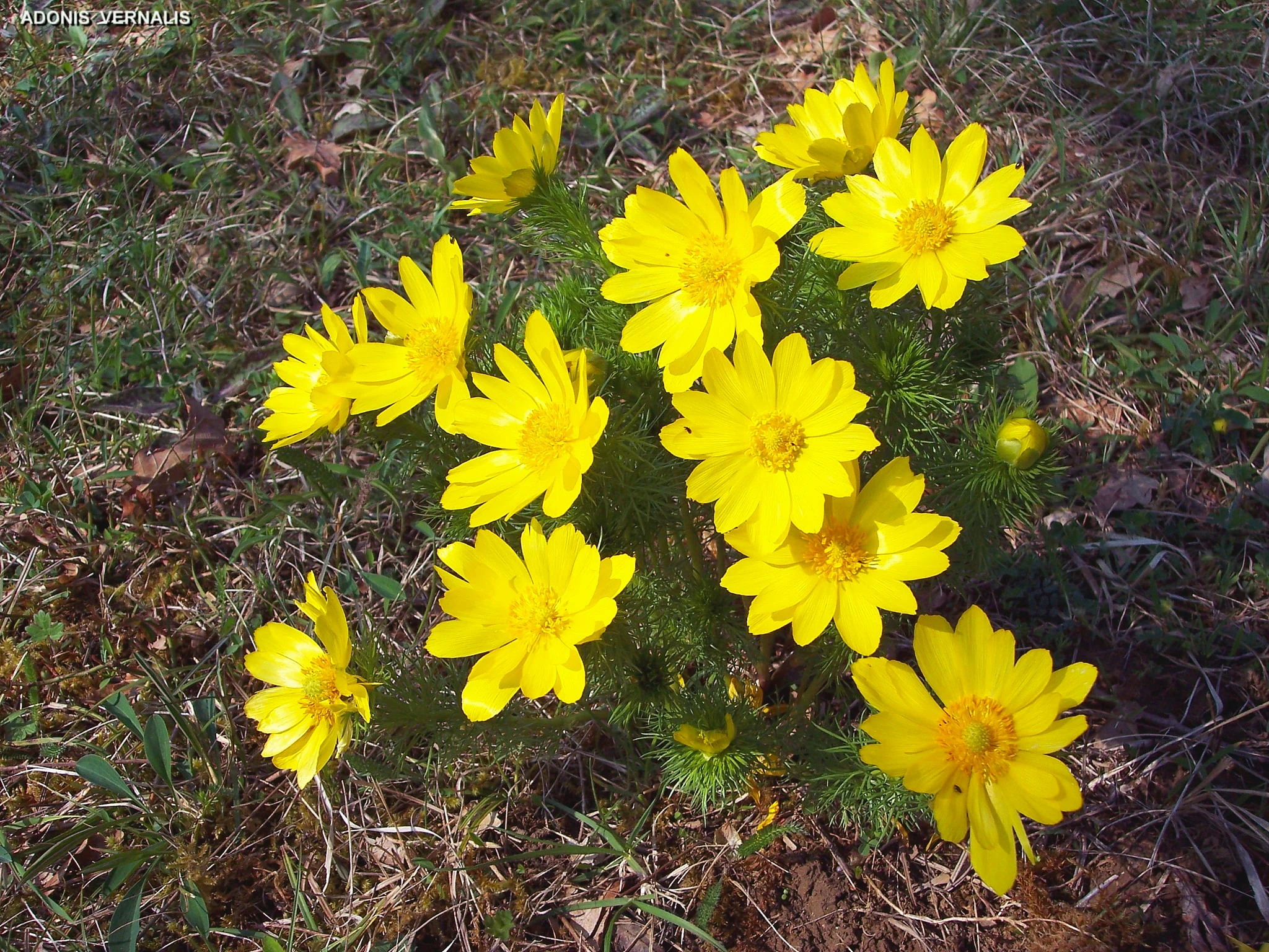
A cluster of vibrant yellow Adonis vernalis flowers growing from a patch of grassy forest ground.
A cluster of Adonis vernalis blooming in the Hardtwald forest.

Mequillet Forest Regional Nature Reserve (Le Hardtwald) history and protected-area timeline

The forest has a long history as a private and ecclesiastical estate rather than a typical forestry property. It originally belonged to the Mequillet family and was subsequently bequeathed to the Protestant consistory of Colmar, which held it for generations and helped maintain its character as an unbroken woodland.

Formal protection began in the early 1990s, when the site was designated as a voluntary nature reserve (réserve naturelle volontaire) by prefectoral decree on 16 November 1993. In 1996, a portion of the woodland of about 66.7 hectares received additional status as a protected forest (forêt de protection), reflecting its recognized role as a major forest ecosystem in the plain.

A new phase of protection came on 16 March 2012, when the site was reclassified as a Regional Nature Reserve (Réserve naturelle régionale) under the new regional framework, with a classification term of 25 years. The reserve has been managed throughout by the Conservatoire des Sites Alsaciens, which has overseen the management plans, including an initial 2001-2006 plan, and the active stewardship of the steppe-like clearings.

Mequillet Forest Regional Nature Reserve (Le Hardtwald) landscape and geographic character

The landscape of Le Hardtwald is defined by the contrast between a flat, open Alsatian plain and an elevated, dry woodland perched above it. The reserve lies on a former Rhine terrace built from coarse alluvium, gravels, and conglomerates, which gives it a subtly higher and drier footprint than the surrounding fields and wetlands of the Upper Rhine plain.

This elevation and the porous nature of the substrate produce a woodland that feels light and warm, with dry soils and relatively open canopies of broadleaf trees. Within this dry forest matrix lie the steppe-like clearings, around 23 hectares of open, grass-dominated openings where thin soils, exposure, and grazing history have produced vegetation with a distinctly continental character more commonly associated with landscapes further east.

From a visitor's perspective, the reserve reads as a long, narrow strip of varied woodland separated into forested sections and open clearings, crossed by a network of paths and a botanical trail in the north. The visual identity is one of dryness, openness, and edge habitat, set against the agricultural matrix of the Rhine plain.

Mequillet Forest Regional Nature Reserve (Le Hardtwald) ecosystems, habitats, and plant life

Ecologically, Le Hardtwald is built around two complementary habitats: dry broadleaf forest and steppe-like clearings, both rare in the Alsace plain. The dry forest develops on free-draining Rhine alluvium and conglomerate terraces, and the combination of low rainfall and a deepening water table amplifies the dryness. This substrate creates a microhabitat more typical of inland continental woodlands than of the wetter elm-oak forests common elsewhere along the Rhine.

The steppe-like clearings introduce an additional distinctive layer, with thin soils and open exposure supporting a flora adapted to dry continental conditions rather than the mesic forest habitats of the surrounding plain. Together, these habitats support a botanical ensemble that includes both forest-floor specialists and species more characteristic of steppe grasslands, making the reserve an important refuge for dry-habitat flora in northeastern France.

The site's ecology is reinforced by the management approach of the Conservatoire des Sites Alsaciens, which maintains the open nature of the clearings and works to preserve the dry woodland structure. The combination of mature broadleaf trees, deadwood, and open dry habitats creates favorable conditions for saproxylic insect communities that depend on the continuity of these features.

Mequillet Forest Regional Nature Reserve (Le Hardtwald) wildlife and species highlights

While the terrestrial mammal community of Le Hardtwald is broadly typical of lowland broadleaf forests in the region, including common forest species such as roe deer and wild boar, it is the insect fauna that stands out ecologically. The reserve is notable for its rich entomological communities associated with mature trees, deadwood, and dry open habitats.

Among the species highlighted by the reserve's documentation are stag beetles (Lucanus cervus), great capricorn beetles (Cerambyx cerdo), and the woodland butterfly known in French as the Grand nègre des bois (Minois dryas). These species are bioindicators of high-quality broadleaf woodland with sufficient deadwood continuity, a habitat condition that Le Hardtwald helps maintain.

The presence of steppe-like clearings also creates opportunities for grassland insects, adding open-ground diversity alongside the forest fauna. For visitors interested in invertebrates and the small-scale wildlife of dry lowland woods, the reserve offers an unusually concentrated example of this ecological combination in the Rhine plain.

Mequillet Forest Regional Nature Reserve (Le Hardtwald) conservation status and protection priorities

The principal conservation value of Le Hardtwald lies in the protection of dry forest and steppe-like grassland habitats that have become rare in the intensively cultivated Upper Rhine plain. By securing a substantial block of forest and open habitat above the alluvial plain, the reserve provides a refuge for species that have retreated elsewhere in the region.

Recognition of the site's importance runs through multiple layers of protection. In addition to the Regional Nature Reserve designation established in 2012, a portion of the same woodland was classified as a protected forest (forêt de protection) by decree in 1996. The reserve is listed under the IUCN management category IV (habitat/species management area) and registered in the World Database on Protected Areas (WDPA 555559621), reflecting its role within international protected-area networks.

The reserve's biodiversity value is closely tied to continuity: the dry forest structure, the presence of mature trees with deadwood, and the maintained openness of the steppe-like clearings all depend on sustained management. The Conservatoire des Sites Alsaciens actively manages these open habitats to counter natural forest encroachment and preserve the dry-substrate flora, making the conservation of the clearings as central as that of the forest itself.

Mequillet Forest Regional Nature Reserve (Le Hardtwald) cultural meaning and human context

The forest has a distinctive cultural lineage compared with many other protected woodlands in France. Rather than being royal, municipal, or monastic property, it originated as a private estate of the Mequillet family and was later bequeathed to the Protestant consistory of Colmar, the institutional body of the local Reformed church.

This ecclesiastical stewardship helped the woodland remain an unbroken mass of trees for generations, despite the intensive agricultural conversion of much of the surrounding Rhine plain. The historical continuity provided by consistorial ownership is part of the explanation for the survival of the dry forest and its associated flora, and gives the reserve a modest but genuine cultural dimension tied to local Protestant heritage.

Top sights and standout views in Mequillet Forest Regional Nature Reserve (Le Hardtwald)

The standout qualities of Le Hardtwald revolve around the rare coincidence of dry forest and steppe-like openings in the Rhine plain, the conservation of continental and sub-continental flora species such as Adonis vernalis and pasqueflower, and the strong saproxylic beetle fauna supported by mature broadleaf woodland.

A botanical trail in the northern part of the site offers a structured way to encounter the habitats, while accessible paths and limited allowances for cyclists and riders keep the reserve usable for low-impact outdoor activities. The richness of the protected site is amplified by its compact size: roughly 249 hectares pack several contrasting dry habitats into a small territory very close to Colmar.

Best time to visit Mequillet Forest Regional Nature Reserve (Le Hardtwald)

The dry, warm character of the reserve means that spring is an especially rewarding period, when the continental flora of the steppe-like clearings is in flower and the woodland edges are at their most vivid. Late spring, when Adonis vernalis and pasqueflower bloom, is a good window for botanical interest.

Summer and early autumn also work well for walking, cycling, or riding along the reserve's paths thanks to the dry substrates and generally well-drained trails, though open clearings can feel exposed in the hottest weather. The compact nature of the site and its proximity to Colmar make it well suited to short visits at any time when conditions are mild and dry, while winter visits remain feasible for those interested in the structure of the dry woodland itself.

Monthly climate preview

Long-term representative temperature ranges and monthly precipitation distributions for regional conservation terrain.

Climate Normals and Annual Weather Patterns in Réserve naturelle régionale de la forêt de Mequillet « Le Hardtwald »

Historical monitoring data records average monthly temperatures shifting from winter lows near zero to warm summer maximums alongside consistent precipitation throughout the year. Reviewing the comprehensive monthly climate profile provides deeper context for analyzing long-term meteorological trends across the protected landscape.
Annual mean10 °C
0 °C20 °C
Jan
Feb
Mar
Apr
May14°
Jun18°
Jul20°
Aug19°
Sep15°
Oct10°
Nov
Dec
Warmest month
July

19.6 °C

Coolest month
January

0.1 °C

Wettest month
May

3 mm/day

Driest month
February

1.7 mm/day

Park location guide

Geography guide, regional context, and park location map for Mequillet Forest Regional Nature Reserve (Le Hardtwald)

Mequillet Forest Regional Nature Reserve (Le Hardtwald) park geography, regions, and map view in France

Understand where Mequillet Forest Regional Nature Reserve (Le Hardtwald) sits in France through a broader geographic reading of the surrounding landscape, nearby location context, and its mapped position within the national park landscape.

How Mequillet Forest Regional Nature Reserve (Le Hardtwald) fits into France

France is a unitary semi-presidential republic and one of the world's largest economies. It borders Belgium, Luxembourg, Germany, Switzerland, Italy, Monaco, Andorra, and Spain, with a maritime border to the United Kingdom. The country is known for its cultural influence, art, cuisine, and political history spanning centuries.

Wider geography shaping Mequillet Forest Regional Nature Reserve (Le Hardtwald) in France

France is located in Western Europe. Metropolitan France extends from the Rhine to the Atlantic Ocean and from the Mediterranean Sea to the English Channel and North Sea. The country borders Belgium, Luxembourg, Germany, Switzerland, Italy, Monaco, Andorra, Spain, and has a maritime border with the United Kingdom.

Map view of Mequillet Forest Regional Nature Reserve (Le Hardtwald)

Use this park location map to pinpoint Mequillet Forest Regional Nature Reserve (Le Hardtwald) in France, understand its exact geographic position, and read its mapped placement within the surrounding landscape more clearly.

Pigeon | © OpenStreetMap contributors

Location context for Mequillet Forest Regional Nature Reserve (Le Hardtwald)

Grand Est

Examine the dry woodland habitats, steppe clearings, and distinctive terrain features of this protected natural area

Visual Exploration and Landscape Photography of Réserve naturelle régionale de la forêt de Mequillet « Le Hardtwald »

Photographic records illustrate the unique dry forest character and open continental clearings perched above the alluvial Rhine plain. Visual documentation reveals the mature broadleaf canopy and terrain variations that define the protected landscape.

A cluster of vibrant yellow Adonis vernalis flowers growing from a patch of grassy forest ground.

Park atlas

Compare surrounding protected landscapes and regional nature reserves across northeastern France

Parks Near Réserve naturelle régionale de la forêt de Mequillet « Le Hardtwald »

Browsing nearby protected areas allows users to examine neighboring woodland reserves and continental habitats sharing the geographic context of the Alsace plain. Extending the comparison reveals broader regional ecosystems and protected landscapes situated along the Upper Rhine valley.
Nature reserveGrand Est
About 15 km away#1 closest

Southwest

Réserve naturelle régionale de l'Eiblen et l'Illfeld: Alsace Floodplain Protected Area

Geographic context of regional alluvial habitats in Haut-Rhin

Located in the Alsace plain, this nature reserve preserves a rare cross-section of original river floodplain geography. The area provides a critical look at alluvial ecosystems and sediment-rich lowland terrain that defines the historical character of the Upper Rhine plain within France.

Area
0.66 km²
Established
1992
Nature reserveGrand Est
About 19 km away#2 closest

West

Réserve naturelle régionale des collines de Rouffach: Protected Hills and Dry Grasslands

A Mediterranean-influenced nature reserve in the Alsace foothills.

Located in the Grand Est region, this reserve preserves Bollenberg and Strangenberg hills through a mosaic of downy oak woodland and xerobrometum grasslands. The site functions as a botanical refuge where limestone geology creates an exceptionally warm, arid environment rare for northeastern France.

Area
0.44 km²
Established
2013
IUCN
IV
A wide panoramic watercolor illustration showing a green landscape with rolling hills, a line of trees, and foreground grass.
Protected landscapeBaden-Württemberg
About 23 km away#3 closest

East

Östliches Hexental: Protected Landscape and Regional Geographic Context in Baden-Württemberg

Black Forest valley mosaic and protected meadow systems

Located in the Breisgau-Hochschwarzwald district, Östliches Hexental forms a vital protected landscape of approximately 526 hectares. The region showcases a traditional Black Forest valley structure, defined by riparian gallery forests, orchard meadows, and small field hedges that provide essential habitat connectivity between the High Black Forest and the Markgräfler Hügelland.

Area
5.264 km²
Established
2008
IUCN
V
A soft watercolor illustration of rolling hills, forested slopes, and meadow vegetation with a light, airy aesthetic.
Nature reserveBaden-Württemberg
About 26 km away#4 closest

Southeast

Belchen Nature Reserve: Exploring the Mountain Geography of the High Black Forest

A diverse protected landscape in Baden-Württemberg

Belchen represents an essential protected area in the southern Black Forest, known for its compressed ecological profile ranging from lowland beech forests to exposed subalpine summits. The site maps a complex mosaic of scree slopes, mires, and rocky habitats that sustain specialized bat species and rare montane flora, offering a detailed perspective on central European highland ecosystems.

Area
29.072 km²
Established
2019
Relief
Mountain
Climate
Temperate
A panoramic watercolor painting depicting a calm wetland or marsh with pink and yellow reeds in the foreground, green trees in the midground, and soft purple mountains in the background.
Nature reserveHaut-Rhin
About 29 km away#5 closest

Southwest

Réserve naturelle régionale des marais et landes du Rothmoos Protected Landscape and Geography

Regional nature reserve in the Haut-Rhin department of Alsace

The Réserve naturelle régionale des marais et landes du Rothmoos encompasses a rare inland saline habitat complex within the Nonnenbruch forest. Its terrain is defined by stable pools created from mining subsidence, transitioning into heathland and oak forests. This protected area stands as an ecological refuge for migratory waterbirds and specialized aquatic species within an industrial-legacy environment.

Area
1.457 km²
Established
1988
IUCN
IV
Relief
Lowland
A watercolor painting showing a wide view of a green field with clumps of trees in the foreground and soft rolling hills in the background under a pale sky.
Nature reserveBas-Rhin
About 31 km away#6 closest

North

Réserve naturelle régionale du Ried de Sélestat, l'Ill*Wald: Protected Alluvial Forest Mapping

Explore the wetland geography and floodplain ecosystem of the Alsatian Grand Ried.

Spanning over 1,800 hectares, the Réserve naturelle régionale du Ried de Sélestat, l'Ill*Wald stands as one of the most significant regional nature reserves in France. This detailed atlas entry reveals its complex hydrological structure, consisting of dense forest, marshland, and a dense web of distributaries shaped by the Ill river and unique phreatic groundwater systems.

Area
18.55 km²
Established
1995
IUCN
IV
Relief
Lowland
A horizontal watercolor illustration showing a winding river through a flat, green landscape with distant hills under a soft pink and yellow sky.
Nature reserveHaut-Rhin
About 36 km away#7 closest

South

Réserve naturelle nationale de la Petite Camargue alsacienne: Protected Rhine Floodplain Geography

A unique wetland and alluvial forest habitat in Haut-Rhin

Investigate the geographic significance of the Réserve naturelle nationale de la Petite Camargue alsacienne. This site acts as a protected reference for Upper Rhine floodplain ecology, showcasing a rare intersection of relict river meanders, marshy depressions, and diverse vegetation types near the French, Swiss, and German borders.

Area
9.04 km²
Established
1982
IUCN
IV
Relief
Lowland
Nature reserveGrand Est
About 38 km away#8 closest

Southwest

Réserve naturelle régionale Im'Berg: Mapping a Unique Protected Nature Reserve in France

A rare calcareous grassland habitat in the Grand Est region.

Réserve naturelle régionale Im'Berg preserves a sun-drenched limestone slope in the commune of Tagolsheim. Known as the Buxberg, this protected area guards one of the most significant natural boxwood populations in Europe alongside specialized dry-habitat flora. The reserve functions as an essential geographic reference for studying how steep, calcareous terrain creates isolated, warm microclimates within the broader Alsatian landscape.

Area
0.017 km²
Established
2013
IUCN
IV

Common questions about visiting, size, designation, and location context for Mequillet Forest Regional Nature Reserve (Le Hardtwald)

Mequillet Forest Regional Nature Reserve (Le Hardtwald) FAQs for park facts, access, geography, and protected area context

Find quick answers about Mequillet Forest Regional Nature Reserve (Le Hardtwald), including protected-area facts, park geography, trail and visitor context, and how the park fits into its surrounding country and regional landscape.
MoriAtlas Explorer

Continue Your Protected Areas Search Across the Global Atlas

Deepen your exploration by continuing the structured search for national parks and protected areas worldwide. Utilize the comprehensive filtering capabilities to compare different conservation landscapes and refine your understanding of global park geography. Discover more about the distribution and characteristics of protected natural areas.

Global natural geography