

Mori Atlas logo
Nature reserveRezerwat przyrody Dolina Smarkatej

Analyzing the fluvial processes and natural river corridors within this protected lowland reserve

Rezerwat przyrody Dolina Smarkatej: Mapped Protected River Valley and Wetland Landscapes in Poland

(Rezerwat przyrody „Dolina Smarkatej")

Rezerwat przyrody Dolina Smarkatej preserves nearly five kilometers of an unregulated, meandering river corridor within Poland. This protected landscape features a complex mosaic of oxbow lakes, lowland peat bogs, and riparian forests that highlight active fluvial dynamics. Situated within the Sandomierz Forest region, the reserve demonstrates the ecological value of free-flowing water systems and citizen-led conservation initiatives.

river valleyfree-flowing rivermeandering riveroxbow lakeslowland peat bogsriparian forest
Stylized flat illustration of a mountain valley with a winding river, a waterfall, and surrounding forests.

Rezerwat przyrody Dolina Smarkatej

Nature reserve

Park overview

Structured park overview, official facts, and landscape profile for Rezerwat przyrody Dolina Smarkatej

Rezerwat przyrody Dolina Smarkatej park facts, protected area profile, and essential visitor context

Review the core facts for Rezerwat przyrody Dolina Smarkatej, including designation, size, terrain, visitor scale, habitats, and operating context in one park-focused overview.

About Rezerwat przyrody Dolina Smarkatej

Rezerwat przyrody Dolina Smarkatej sits in the lowland landscape of the Mielecko-Kolbuszowsko-Głogowski Protected Landscape Area, in the northwestern part of the historical Sandomierz Forest. Its territory belongs to two forest districts, Nowa Dęba and Mielec, and spans the communes of Cmolas and Majdan Królewski. The reserve centers on the lower, still unregulated course of the small Smarkata river, capturing almost five kilometers of channel along with the immediate valley, riparian forest, and associated wetlands.

What makes this protected area distinctive is the degree to which natural river processes have been preserved. The Smarkata retains its original meandering pattern, carving a crossing through a low dune-like ridge known as Smarkata Góra, which rises to roughly 198 meters above sea level. Within the reserve, the river corridor includes abandoned meanders evolving into oxbow lakes, lowland peatlands along former channels, and active floodplain features such as seasonal pools and accumulations of woody debris. Beaver dams and fallen trees are visible features shaping the channel and slowing the flow.

The reserve also has a layered cultural dimension. The protected landscape includes remains of two historic bridges dating to the Second World War, traces of older human presence, and a documented botanical history: the local flora was already described in the interwar period by the eminent Polish botanist Władysław Szafer. Together, these ecological, geomorphological, and historical threads give Dolina Smarkatej a strong identity as a small but content-rich nature reserve within a wider network of protected forest and river landscapes in southeastern Poland.

Quick facts and research context for Rezerwat przyrody Dolina Smarkatej

Dolina Smarkatej is a Polish landscape nature reserve of the subtype "natural landscapes," covering roughly 55.94 hectares with an additional protective buffer zone of about 155.11 hectares. It was established on 18 April 2024 by order of the Regional Director of Environmental Protection in Rzeszów. The reserve lies in Kolbuszowski County, Podkarpackie Voivodeship, within the forest districts of Nowa Dęba and Mielec, and overlaps with both a protected landscape area and a Natura 2000 bird site (Puszcza Sandomierska PLB180005). Its core feature is an almost five-kilometer unregulated section of the Smarkata river that breaks through the Smarkata Góra dune ridge at about 198 meters above sea level.

Protection and recognition

Examine the documented conservation framework and designation history for this protected area.

Rezerwat przyrody Dolina Smarkatej Protection Status and Recognition

Rezerwat przyrody Dolina Smarkatej protection status details incorporate available conservation records and administrative frameworks. Structured data entries organize the recorded designation history and formal recognition parameters for geographic analysis.

Protection details

Buffer area
1.55 km²
Park context

Deeper park guide and search-rich context for Rezerwat przyrody Dolina Smarkatej

Rezerwat przyrody Dolina Smarkatej history, landscape, wildlife, and travel context

Explore Rezerwat przyrody Dolina Smarkatej through its history, landscape character, ecosystems, wildlife, conservation priorities, cultural context, and seasonal travel timing in a structured park guide built for atlas discovery and search intent.

Why Rezerwat przyrody Dolina Smarkatej stands out

The reserve is best known for protecting a free-flowing, meandering stretch of the Smarkata river with intact fluvial and peat-forming dynamics. It is one of the most recently created reserves in Poland and stands out for its oxbow lakes, small lowland peat bogs, beaver-modified channels, and rich assemblages of protected flora and freshwater fauna. The site is also notable as a model of grassroots conservation, having been proposed and documented by the Podkarpackie Society of Naturalists "Free Rivers."
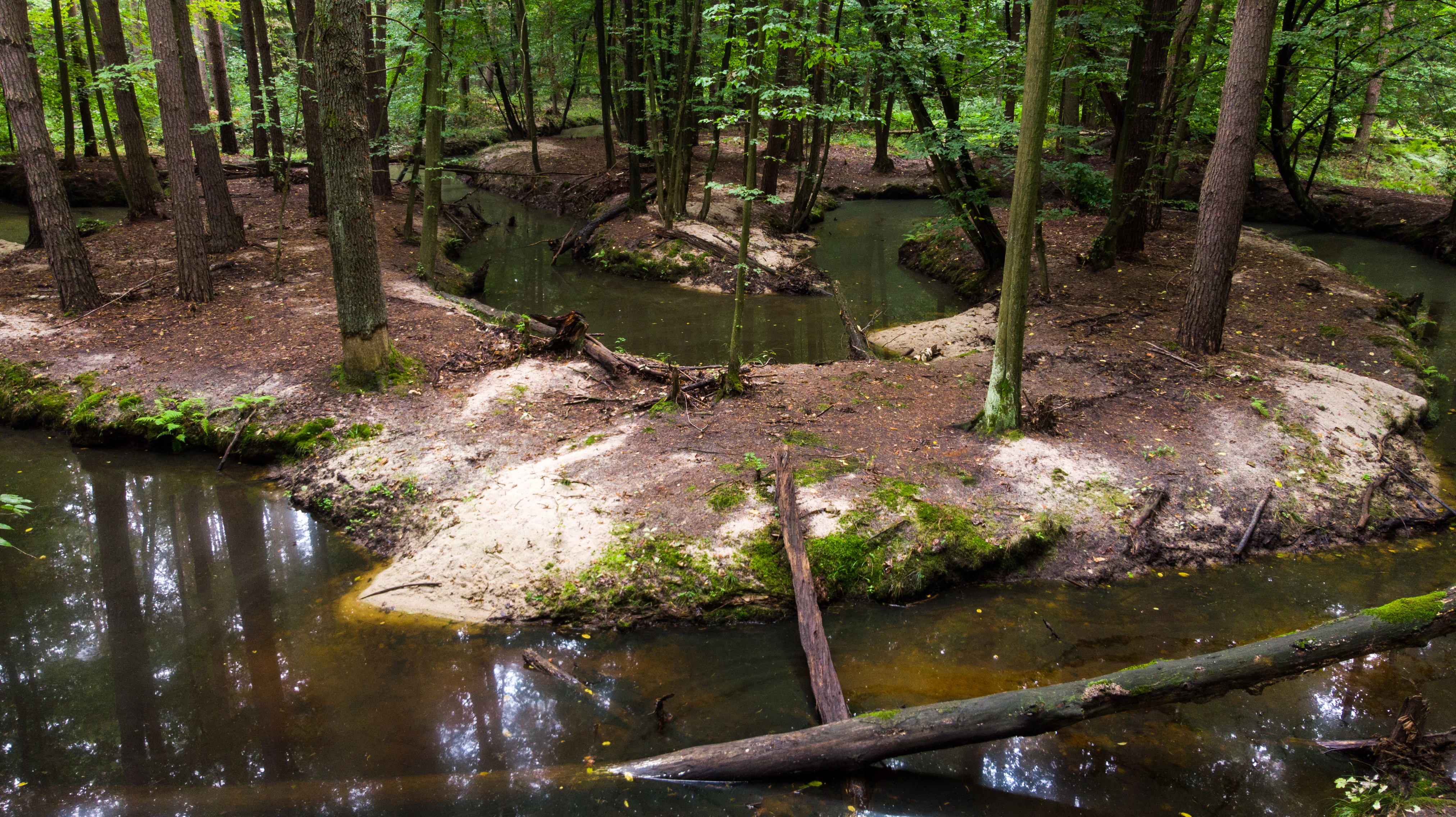
A winding narrow stream flows through a forested area with sandy banks and fallen logs.
The Smarkata stream flowing through a dense forest in the Rezerwat przyrody Dolina Smarkatej.

Rezerwat przyrody Dolina Smarkatej history and protected-area timeline

The reserve is very recent in formal terms. It was created on 18 April 2024 by an order of the Regional Director of Environmental Protection in Rzeszów dated 2 April 2024, published in the official journal of the Podkarpackie Voivodeship. The designation followed years of grassroots effort by the Podkarpackie Society of Naturalists "Free Rivers" (Wolne Rzeki), which carried out a field inventory of the site in 2017 and 2018 and in 2019 submitted a formal proposal to the regional environmental authority requesting protection. The original proposal envisioned a larger reserve area than what was ultimately established.

Although the reserve itself is new, the natural values it protects have been recognized for much longer. The plant communities along the Smarkata river were already characterized in scientific literature during the interwar period by the botanist Władysław Szafer, one of Poland's most influential twentieth-century naturalists. The wartime-era bridges that still stand within the area add a human-historical layer, reflecting the strategic and rural character of the region during the Second World War. Since the reserve was only recently created, it had, as of April 2024, no approved protection plan or set of conservation tasks, leaving its detailed management framework yet to be developed.

Rezerwat przyrody Dolina Smarkatej landscape and geographic character

The landscape of Dolina Smarkatej is a typical lowland river valley within the broader Nizina Nadwiślańska mesoregion. The reserve is shaped by the valley of the Smarkata river, which here retains the natural winding pattern of an unregulated lowland stream rather than the straightened channel common elsewhere in Poland's agricultural lowlands.

A defining local feature is Smarkata Góra, a low dune-like ridge around 198 meters above sea level that crosses the valley. The river cuts through this sandy elevation, creating a small natural "breakthrough" that adds vertical interest to an otherwise gently rolling terrain. Around the channel, the valley floor is dotted with abandoned meanders transitioning into oxbow lakes and small lowland peat bogs, while the higher ground carries forest belonging to the state forest districts of Nowa Dęba and Mielec.

The wet elements dominate visually: cut-off meanders, marshy pockets, peat-forming zones, fallen trees spanning the channel, and beaver-built dams all give the corridor a strongly process-driven, "living river" appearance. Combined with the surrounding forests of the Sandomierz Forest, the result is a varied but compact landscape mosaic of dry sandy ridges, mixed forest, wet meadows, and flowing water.

Rezerwat przyrody Dolina Smarkatej ecosystems, habitats, and plant life

Ecologically, the reserve exists to preserve natural river dynamics and the habitats they create. The official protection goal targets the undisturbed character of the Smarkata, specifically maintaining intact fluvial processes and peat-forming dynamics along its course. From a typological standpoint, the area is classified as protecting a mix of ecosystems, with forests and waters as the dominant subtypes.

The reserve's vegetation mosaic includes riverine and swamp forest communities linked to the floodplain, peat bog vegetation along former channels and seepage zones, and wet meadow or marsh patches where conditions allow. The dune ridge of Smarkata Góra introduces drier pine-associated forest types nearby, creating a sharp ecological contrast within a small area. This juxtaposition of dry sandy uplands and waterlogged valley floor supports a relatively rich flora.

In terms of flora, the reserve hosts protected and regionally notable species including the carnivorous common bladderwort, which floats in stiller stretches and oxbows, the spring-flowering shrub mezereon, and common bog bean, a classic indicator of base-rich, calcareous wetland habitats. Together, these features make the reserve a compact but ecologically diverse site where water, peat, and forest processes interact.

Rezerwat przyrody Dolina Smarkatej wildlife and species highlights

Wildlife in Dolina Smarkatej is closely tied to the structure of the river and its floodplain. Freshwater fauna benefits from the clean, oxygen-rich, structurally complex channel. The reserve supports the noble crayfish, a strictly protected and ecologically sensitive species whose presence indicates good water quality and intact bottom substrate.

Mammals are not heavily documented in the source material, but beavers are functionally central to the river ecosystem here. Their dams, lodged woody debris, and ponds reshape the channel and influence water levels in the oxbows and side pools. The dense riparian forest surrounding the channel provides cover for typical lowland forest mammal species, while the mosaic of wet meadows, peatlands, and woodland offers varied foraging conditions for bats, small carnivores, and ungulates typical of the Sandomierz Forest region.

The reserve lies within the Natura 2000 bird area Puszcza Sandomierska PLB180005, meaning its broader landscape context is considered important for bird species of European concern. The combination of open water, riparian woodland, marshy patches, and dry forest patches makes the wider area valuable for breeding, feeding, and migrating birds, even though species-level bird lists for the reserve itself are not detailed in the available sources.

Rezerwat przyrody Dolina Smarkatej conservation status and protection priorities

Dolina Smarkatej is significant from a conservation perspective because it preserves a free-flowing river corridor that remains rare in lowland Poland. The reserve's stated purpose is to maintain natural fluvial and peat-forming processes, which have been heavily disrupted elsewhere by channel straightening, drainage, and intensive agriculture. By safeguarding oxbow formation, peat accumulation, and natural flooding dynamics, the reserve helps maintain ecological functions that have largely vanished from surrounding landscapes.

The site also strengthens an existing layered protection network. It sits within the Mielecko-Kolbuszowsko-Głogowski Protected Landscape Area and overlaps with the Natura 2000 site Puszcza Sandomierska PLB180005, reinforcing protection for the broader Sandomierz Forest and its bird populations. The presence of protected species such as the noble crayfish underscores the conservation value of water quality and habitat continuity.

Beyond its ecological role, the reserve is a notable example of NGO-driven conservation in Poland. The Podkarpackie Society of Naturalists "Free Rivers" generated the underlying inventory and petition, illustrating how local naturalist groups can influence regional protection decisions. As of April 2024, however, the reserve still lacked an approved protection plan or formal conservation tasks, marking the beginning of its management phase.

Rezerwat przyrody Dolina Smarkatej cultural meaning and human context

Culturally, the reserve is tied to the identity of the Sandomierz Forest region, an area historically associated with extensive woodlands, small rural communities, and traditional land use patterns that have largely given way to modern forestry and agriculture. Within the reserve, the remains of two historic bridges from the Second World War period link the landscape to the area's more recent history, hinting at the strategic and everyday movement of people through this rural lowland corridor during the mid-twentieth century.

The site also carries a scientific-cultural heritage through the work of Władysław Szafer, whose interwar botanical descriptions of the local vegetation helped establish the region's ecological significance in Polish natural science. The grassroots campaign led by the Podkarpackie Society of Naturalists "Free Rivers" further embeds the reserve within a contemporary Polish tradition of civil society engagement in river conservation. Together, these threads connect the reserve not only to natural processes but also to regional identity and citizen-led environmentalism.

Top sights and standout views in Rezerwat przyrody Dolina Smarkatej

Nearly five kilometers of free-flowing, meandering Smarkata river with intact fluvial and peat-forming processes.

A compact mosaic of oxbow lakes, lowland peat bogs, riparian forest, and a sandy dune-like ridge (Smarkata Góra, around 198 m above sea level).

Protected and ecologically sensitive species such as noble crayfish, common bladderwolf, mezereon, and common bog bean.

Recent designation (April 2024) following an inventory and proposal by the Podkarpackie Society of Naturalists "Free Rivers."

Historical layers including remains of Second World War-era bridges and interwar botanical documentation by Władysław Szafer.

Position within the Mielecko-Kolbuszowsko-Głogowski Protected Landscape Area and the Natura 2000 site Puszcza Sandomierska PLB180005.

Best time to visit Rezerwat przyrody Dolina Smarkatej

Because the reserve is currently not officially open to visitors and detailed seasonal access guidance is not provided in the source material, broad timing advice must remain cautious. For similar lowland river valleys in southeastern Poland's Podkarpackie region, late spring is typically a strong period for viewing wetland vegetation and breeding bird activity, while early autumn often offers favorable water levels, milder conditions, and rich forest colors. Cooler months can highlight geomorphological features such as oxbows and beaver dams more clearly, when vegetation is less dense. Visitors should treat the area as ecologically sensitive and respect any access restrictions in place.


Monthly climate preview

Long-term representative point measurements tracking monthly temperature and precipitation variation

Rezerwat przyrody Dolina Smarkatej Climate Normals and Temperature Rhythms

Historical data recorded at a representative coordinate reveals distinct annual temperature shifts alongside measured precipitation variations for Rezerwat przyrody Dolina Smarkatej. Examining the complete twelve-month profile provides deeper analytical context regarding long-term climate normals across the protected area.
Annual mean9 °C
-4 °C21 °C
Jan-4°
Feb-2°
Mar
Apr
May15°
Jun19°
Jul21°
Aug20°
Sep15°
Oct
Nov
Dec-2°
Warmest month
July

20.8 °C

Coolest month
January

-3.6 °C

Wettest month
July

2.8 mm/day

Driest month
January

1.2 mm/day

Park location guide

Geography guide, regional context, and park location map for Rezerwat przyrody Dolina Smarkatej

Rezerwat przyrody Dolina Smarkatej park geography, regions, and map view in Poland

Understand where Rezerwat przyrody Dolina Smarkatej sits in Poland through a broader geographic reading of the surrounding landscape, nearby location context, and its mapped position within the national park landscape.

How Rezerwat przyrody Dolina Smarkatej fits into Poland

Poland, officially the Republic of Poland, is a Central European country spanning from the Baltic Sea in the north to the Carpathian Mountains in the south. It borders Germany, Czech Republic, Slovakia, Ukraine, Belarus, Lithuania, and Kaliningrad Oblast. The country has a temperate climate, diverse landscapes, and is known for its rich history, cultural heritage, and strong economic position within the EU.

Wider geography shaping Rezerwat przyrody Dolina Smarkatej in Poland

Poland occupies 312,696 km2 in Central Europe, extending from the Baltic Sea coast in the north to the Sudetes and Carpathian Mountains in the south. It borders Germany to the west, Czech Republic and Slovakia to the south, Ukraine and Belarus to the east, and Lithuania and Kaliningrad Oblast to the northeast. The landscape includes lowland plains, uplands, and mountain ranges.

Map view of Rezerwat przyrody Dolina Smarkatej

Use this park location map to pinpoint Rezerwat przyrody Dolina Smarkatej in Poland, understand its exact geographic position, and read its mapped placement within the surrounding landscape more clearly.

Pigeon | © OpenStreetMap contributors

Visualizing the river valley, meandering waters, and protected wetland habitats

Rezerwat przyrody Dolina Smarkatej Photos and Landscapes

Visual records document the meandering river channel, oxbow lakes, and wetland habitats that define the protected landscape of Rezerwat przyrody Dolina Smarkatej. Photographic views offer direct insight into the terrain, forest mosaics, and fluvial processes shaping the protected river corridor.

A winding narrow stream flows through a forested area with sandy banks and fallen logs.

Park atlas

Compare nearby river valleys and connected conservation areas across the surrounding region

Parks Near Rezerwat Przyrody Dolina Smarkatej and Regional Protected Landscapes

Browse other protected areas and river valley reserves located near Rezerwat przyrody Dolina Smarkatej. Comparing adjacent natural habitats helps contextualize regional river dynamics and broader lowland conservation patterns.
Protected landscapeTarnobrzeska Dolina Wisły
About 17 km away#1 closest

North

Tarnobrzeska Dolina Wisły Protected Landscape: Mapped Riverine Geography and Habitat Corridor

A sprawling Vistula valley floodplain site in southeastern Poland.

The Tarnobrzeska Dolina Wisły protected area encompasses a 4,060-hectare corridor of rare lowland habitats. This map-focused site highlights an ecologically active river system composed of riparian forests, shifting banks, and extensive wetlands that define the regional geography of the middle Vistula basin.

Area
40.597 km²
Established
2011
Scope
Terrestrial
Water
Major water bodies
Nature reserveświętokrzyskie
About 21 km away#2 closest

Northwest

Ostoja Żyznów Protected Landscape: Loess Ravines and River Valleys of Świętokrzyskie

A dense mosaic of xerothermic grasslands and mixed forest ecosystems

Ostoja Żyznów protects a compact yet ecologically rich region characterized by deep loess gullies and the meandering paths of the Koprzywianka and Kacanka rivers. The area creates a striking transitional landscape, shifting from flat agricultural plateaus to steep, forest-covered ravines and cliff-like river walls. This site offers significant value for understanding regional biodiversity, featuring a rare combination of warm-dry grasslands and moisture-dependent peatland habitats in the heart of Poland.

Area
44.8 km²
Established
2011
Relief
Mixed relief
Climate
Temperate
A horizontal watercolor painting showing a stylized landscape with rolling green hills, a forest of trees, and distant purple-hued mountains under a soft light.
Nature reservePodkarpackie Voivodeship
About 27 km away#3 closest

Southwest

Rezerwat przyrody Bagno Przecławskie: Mapped Peatland and Protected Forest Geography

Protected wetland landscapes in Podkarpackie Voivodeship

Examine the geographic profile of Rezerwat przyrody Bagno Przecławskie, a significant nature reserve in the Sandomierz Basin. This protected area features open peatland, floating bog mats, and forest transition zones, providing a clear window into the ecological history and lowland wetland terrain of this unique Polish region.

Area
0.256 km²
Established
1979
Relief
Lowland
Climate
Temperate
Protected areaPoland
About 41 km away#4 closest

Northeast

Uroczyska Lasów Janowskich: Protected Forest and Wetland Geography in Eastern Poland

Mapping the extensive Natura 2000 lowland forest and peatland complexes

Spanning the Biłgoraj Plain and San River valley, Uroczyska Lasów Janowskich is a notable lowland forest complex in Poland. Its terrain integrates mature oak-hornbeam woods with diverse peatland systems, offering a clear look at how layered conservation strategies protect rare European habitats within a single continuous geographic block.

Area
345.443 km²
Established
2009
Relief
Lowland
Climate
Temperate
Nature reservePodkarpackie Voivodeship
About 46 km away#5 closest

South

Wisłok Środkowy z Dopływami Protected Nature Reserve in the Podkarpackie Voivodeship

River corridor geography and riparian ecosystem analysis

Wisłok Środkowy z Dopływami serves as a crucial Natura 2000 site, safeguarding the middle course of the Wisłok River and the Stobnica tributary. This nature reserve provides essential habitat for various protected fish species and butterfly populations within a terrain shaped by the transition between the Jasielsko-Krośnieńska Basin and the Carpathian foothills. The area represents a significant riparian landscape, offering a window into the natural freshwater geography of southeastern Poland.

Area
10.646 km²
Established
2011
Relief
Upland
Scope
Terrestrial
Protected areaPodkarpackie Voivodeship
About 53 km away#6 closest

South

Wisłoka z dopływami Protected Area: River Valley Landscape and Carpathian Foothills Atlas

Freshwater habitat mapping in southern Poland

Wisłoka z dopływami covers a long, ecologically rich segment of the Wisłoka river valley in the Carpathian foothills. This protected area connects diverse riparian, floodplain, and alluvial forests, serving as a critical habitat for six Annex II fish species and sixteen distinct riparian woodland types.

Area
26.51 km²
Established
2011
Relief
Mixed relief
Scope
Terrestrial
Nature reserveLubelskie Voivodeship
About 53 km away#7 closest

Northeast

Szczecyn Nature Reserve: Mapping Protected Deciduous Forest Habitats in Eastern Poland

A vital mosaic of oak-hornbeam forest enclaves and nature reserves.

Szczecyn functions as a specialized Natura 2000 conservation landscape, spanning four forest enclaves across the border of the Lubelskie and Podkarpackie voivodeships. This site provides an essential reference for lowland deciduous forest protection, emphasizing the preservation of old-growth oak-hornbeam stands and thermophilic habitats. The area serves as a critical refuge for rare flora and invertebrates within a broader agricultural mosaic.

Area
9.325 km²
Established
2011
Relief
Upland
Climate
Temperate
Protected landscapeŚwiętokrzyskie Voivodeship
About 56 km away#8 closest

West

Szaniecki Park Krajobrazowy: Protected Landscape Atlas and Regional Map Context

Exploring xerothermic habitats across the Ponidzie plateau

Szaniecki Park Krajobrazowy anchors conservation efforts across the Płaskowyż Szaniecki and the Garb Pińczowski ridge. This detailed profile tracks the regional geography, calcareous soil influence, and the protection of rare steppe flora within the broader Świętokrzyskie Voivodeship landscape framework.

Area
112.896 km²
Established
1986
Relief
Upland
Climate
Temperate

Common questions about visiting, size, designation, and location context for Rezerwat przyrody Dolina Smarkatej

Rezerwat przyrody Dolina Smarkatej FAQs for park facts, access, geography, and protected area context

Find quick answers about Rezerwat przyrody Dolina Smarkatej, including protected-area facts, park geography, trail and visitor context, and how the park fits into its surrounding country and regional landscape.
MoriAtlas Explorer

Continue Your Protected Areas Search Across the Global Atlas

Deepen your exploration by continuing the structured search for national parks and protected areas worldwide. Utilize the comprehensive filtering capabilities to compare different conservation landscapes and refine your understanding of global park geography. Discover more about the distribution and characteristics of protected natural areas.

Global natural geography