

Mori Atlas logo
National parkSacromonte National Park

Explore the mapped boundaries and regional landscape of this protected national park.

Sacromonte National Park: Protected Area Identity and Geographic Atlas Context

Sacromonte National Park stands as a significant protected area within the State of Mexico, offering a unique focus for geographic and atlas exploration. This page details the park's identity as a national park, highlighting its mapped boundaries and the surrounding natural landscape context. Users can delve into the specific geography that defines Sacromonte National Park, understanding its place within the regional terrain and its value as a distinct protected landscape for structured discovery.

National ParkProtected AreaCentral MexicoState of MexicoHighland EcosystemsBiodiversity Hotspot

Sacromonte National Park

National park

Park overview

Structured park overview, official facts, and landscape profile for Sacromonte National Park

Sacromonte National Park park facts, protected area profile, and essential visitor context

Review the core facts for Sacromonte National Park, including designation, size, terrain, visitor scale, habitats, and operating context in one park-focused overview.

About Sacromonte National Park

Sacromonte National Park is a designated protected area in central Mexico, situated within the State of Mexico (Estado de México) that surrounds Mexico City. The park was created to preserve natural ecosystems in a region where agricultural conversion and urban expansion have dramatically altered the landscape. As one of Mexico's national parks, it receives protection under the country's federal environmental framework and is managed by the National Commission of Natural Protected Areas (CONANP). The park's small size makes it distinctive among Mexico's protected areas, demonstrating that even compact reserves can provide meaningful ecological value when they protect representative habitats. The central Mexican highlands where the park is located feature unique environmental conditions that support specialized plant and animal communities adapted to the region's climate and elevation.

Quick facts and research context for Sacromonte National Park

Sacromonte National Park covers approximately 45 hectares (0.44 square kilometers) in the State of Mexico, making it one of Mexico's smaller national parks. The park is administered by the National Commission of Natural Protected Areas (CONANP) and falls under IUCN Category II protection. Located at coordinates approximately 19.12887°N, 98.77485°W, the park sits in the central Mexican highlands at an elevation that supports unique ecological communities adapted to this mid-altitude environment. The establishment of this protected area reflects mid-20th century conservation efforts in Mexico.

Protection and recognition

Documenting terrestrial boundaries and designation history since 1952

Sacromonte National Park Official Protection Status and Conservation History

Established in 1952, Sacromonte National Park maintains a dedicated terrestrial protection scope that safeguards its geographical boundaries. Tracking such historical conservation designations provides vital context for understanding regional biodiversity management and global protected area datasets.

Protection details

Protection scope
Terrestrial
Designated year
1952
Transboundary protection
No
Park context

Deeper park guide and search-rich context for Sacromonte National Park

Sacromonte National Park history, landscape, wildlife, and travel context

Explore Sacromonte National Park through its history, landscape character, ecosystems, wildlife, conservation priorities, cultural context, and seasonal travel timing in a structured park guide built for atlas discovery and search intent.

Why Sacromonte National Park stands out

Sacromonte National Park is best known as a small but significant protected area in central Mexico's State of Mexico. It represents one of the few protected green spaces in this densely populated region, providing habitat for more than 250 species of plants and animals. The park's biodiversity includes several species that fall within risk categories under Mexican environmental regulations (NOM-059), highlighting its conservation importance despite its modest size.

Sacromonte National Park history and protected-area timeline

The establishment date of Sacromonte National Park shows some variation between sources, with English-language references noting 1952 as the year of establishment while Spanish-language sources indicate 1939. This discrepancy may reflect different interpretations of when the area first received formal protected status versus when it received its current national park designation. Regardless, the park emerged from Mexico's mid-20th century conservation movement, which established national parks as a primary tool for protecting representative natural areas across the country. The park's small area reflects both the limited remaining natural habitat in this heavily populated region and the prioritization of preserving even modest conservation areas. Today, the park continues to operate under the management framework established by Mexico's protected areas system.

Sacromonte National Park landscape and geographic character

Sacromonte National Park occupies a modest area in the central Mexican highlands, a region characterized by undulating terrain, volcanic soils, and a climate that supports mixed grasslands, scrubland, and forest patches. The landscape around the park reflects the broader ecological character of the State of Mexico, where natural vegetation has been extensively modified by agriculture and human settlement. Within the park's boundaries, the terrain provides habitat diversity that supports the area's biodiversity, with gentle slopes and natural vegetation providing contrast to the intensively cultivated lands surrounding the protected zone.

Sacromonte National Park ecosystems, habitats, and plant life

The park supports remarkable biodiversity for its size, with more than 250 species of plants and animals recorded within its boundaries according to Mexico's National Biodiversity Information System (CONABIO). This biodiversity includes species representing various ecological groups, from forest-dwelling organisms to grassland species adapted to open habitats. The central Mexican highlands host unique ecological communities that have evolved in isolation from other mountain systems, making the conservation of these habitats important for preserving regional biodiversity patterns. The park functions as a refugium for native species in a landscape where natural habitat has become increasingly fragmented.

Sacromonte National Park wildlife and species highlights

The wildlife community within Sacromonte National Park includes species adapted to central Mexican highland environments. The park's biodiversity inventory includes several species that have been categorized according to Mexico's official risk listing (NOM-059), indicating that some resident species face conservation concerns and benefit from the protection the park provides. Additionally, the park contains both native species and introduced exotic species, with approximately 24 exotic species recorded alongside the native community. This mix reflects both the park's ecological value and the challenges of maintaining ecological integrity in a fragmented landscape.

Sacromonte National Park conservation status and protection priorities

Sacromonte National Park represents an important conservation node within the heavily modified landscape of central Mexico. The park's inclusion of species at risk according to Mexican environmental standards (NOM-059) underscores its significance for protecting vulnerable populations. Despite its small size, the park contributes to regional biodiversity conservation by maintaining a protected area where native species can persist. The presence of eight species in risk categories highlights the conservation value this small protected area provides, demonstrating that even compact reserves serve important ecological functions when they protect quality habitat.

Top sights and standout views in Sacromonte National Park

Sacromonte National Park stands out as a small but significant protected area in one of Mexico's most densely populated regions. The park's biodiversity—containing over 250 species including eight species in conservation risk categories—demonstrates the ecological importance of preserving even compact green spaces. As a Category II protected area, it represents Mexico's commitment to maintaining representative natural ecosystems across the country's diverse environmental regions. The park provides a rare natural habitat island within the agricultural and urban matrix of the State of Mexico.

Best time to visit Sacromonte National Park

The central Mexican highlands experience a temperate climate with distinct wet and dry seasons. The best time to visit Sacromonte National Park typically falls during the dry season from November through April, when precipitation is minimal and trail conditions are most favorable. The winter months often offer clear skies and pleasant temperatures for outdoor exploration. Visitors should note that the park's small size and location in a populated region may affect access, and checking current access conditions with local authorities is advisable before planning a visit.
Monthly climate preview

Trace long term average monthly temperatures and precipitation patterns across the protected terrain

Sacromonte National Park Climate Normals and Annual Temperature Rhythm

Sacromonte National Park registers measured monthly climate normals spanning from cooler baseline temperatures to warmer midday maximums alongside distinct precipitation shifts. Reviewing the complete twelve month dataset provides deeper meteorological context for the protected area.
Annual mean17 °C
14 °C20 °C
Jan14°
Feb16°
Mar18°
Apr20°
May20°
Jun19°
Jul17°
Aug17°
Sep17°
Oct16°
Nov15°
Dec14°
Warmest month
May

20.4 °C

Coolest month
January

13.9 °C

Wettest month
September

5.9 mm/day

Driest month
December

0.3 mm/day

Park location guide

Geography guide, regional context, and park location map for Sacromonte National Park

Sacromonte National Park park geography, regions, and map view in Mexico

Understand where Sacromonte National Park sits in Mexico through a broader geographic reading of the surrounding landscape, nearby location context, and its mapped position within the national park landscape.

How Sacromonte National Park fits into Mexico

Mexico, officially the United Mexican States, is a country in North America spanning the Sierra Madre mountain ranges, coastal plains, and tropical regions. It borders the United States to the north, Guatemala and Belize to the southeast, and has coastlines along the Pacific Ocean, Gulf of Mexico, and Caribbean Sea. With a population exceeding 130 million, Mexico is home to one of the world's most significant concentrations of Indigenous languages alongside Spanish.

Wider geography shaping Sacromonte National Park in Mexico

Mexico occupies a land area of 1,972,550 km2, making it the thirteenth-largest country in the world. The terrain is highly diverse, featuring the Sierra Madre Occidental and Sierra Madre Oriental mountain ranges, the Mexican Plateau, coastal lowlands along the Pacific and Gulf/Caribbean margins, and the Yucatan Peninsula. The country spans multiple climate zones from desert in the north to tropical rainforest in the south.

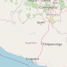
Map view of Sacromonte National Park

Use this park location map to pinpoint Sacromonte National Park in Mexico, understand its exact geographic position, and read its mapped placement within the surrounding landscape more clearly.

Pigeon | © OpenStreetMap contributors

Location context for Sacromonte National Park

State of Mexico
Park atlas

Compare conservation landscapes, mapped terrain, and protected areas across the central Mexican highlands surrounding Sacromonte National Park.

Explore Nearby National Parks and Protected Areas in Central Mexico After Sacromonte National Park

Continue your park discovery beyond Sacromonte National Park by browsing additional protected areas and national parks throughout central Mexico. Compare their diverse landscapes, conservation objectives, and regional significance to gain a broader understanding of Mexico's protected heritage in the State of Mexico and surrounding highlands.
National parkMexico
About 17 km away#1 closest

Northeast

Iztaccíhuatl, Popocatépetl National Park: Mexico's National Park Protected Area

Mapped boundaries and regional geographic context.

Iztaccíhuatl, Popocatépetl National Park is a protected natural landscape offering insight into Mexico's geography. This atlas entry focuses on the park's defined boundaries and its role within the national protected areas framework. Explore the unique geographic character and mapped extent of this significant park, understanding its position within the country's natural landscape atlas.

Area
398.19 km²
Established
1935
IUCN
II
Relief
Mountain
Protected areaMorelos
About 31 km away#2 closest

Southwest

Corredor biológico Chichinautzin: Protected Area and Volcanic Highland Geography

Mapping the biological corridor between Morelos and the Mexican highlands

As a strategic biological corridor, Corredor biológico Chichinautzin preserves a rugged, volcanic landscape of pine forests and deep ravines. The protected area ensures essential connectivity between major national parks and provides a critical water source for the surrounding region, marking it as a centerpiece of ecological conservation in the central Mexican highlands.

Area
378.73 km²
Established
1988
Scope
Terrestrial
Water
Major water bodies
National parkMorelos
About 40 km away#3 closest

Southwest

El Tepozteco National Park: Protected National Park in Morelos

Explore the mapped geography and protected landscape of this Mexican national park.

Delve into El Tepozteco National Park, a key protected area designated as a national park within the Morelos region of Mexico. This profile provides detailed insight into its mapped boundaries and its significance within the broader regional geography. It serves as a resource for understanding the park's protected landscape and its context for atlas-based geographic exploration.

Area
232.587 km²
Established
1937
IUCN
II
Relief
Mountain
National parkMexico City
About 41 km away#4 closest

Northwest

Cerro de la Estrella National Park: Mapped Protected Landscape and Regional Geography

Explore the national park's mapped boundaries within Mexico City.

Cerro de la Estrella National Park represents a key protected area for geographic study and atlas exploration within the urban landscape of Mexico City. This entry provides detailed insight into the park's mapped boundaries and its role as a national park, highlighting its unique protected landscape character. Understand its position within the regional geography and explore what makes this park an important feature for mapped terrain and conservation awareness.

Area
1.5 km²
Established
1938
IUCN
II
Relief
Mixed relief
National parkState of Mexico
About 43 km away#5 closest

North

Molino de Flores Nezahualcóyotl National Park: National Park Protected Landscape Exploration

Mapped geographic context within the State of Mexico.

Access structured details about Molino de Flores Nezahualcóyotl National Park, a significant protected area designated as a national park. This entry focuses on its role as a mapped landscape, providing essential geographic context for understanding its boundaries and natural terrain. Discover how this protected area contributes to the broader atlas of conservation lands in the region.

Area
0.49 km²
Established
1937
IUCN
II
Visitors
10K annual
National parkMexico
About 46 km away#6 closest

West

Fuentes Brotantes de Tlalpan National Park: National Park Geographic Atlas and Terrain Exploration

Explore protected land boundaries and mapped natural landscapes.

Delve into the geographic specifics of Fuentes Brotantes de Tlalpan National Park, a protected national park situated within Mexico. This detailed view highlights the park's mapped terrain and its significance as a distinct natural landscape. Understand its role in the country's protected area network and its contribution to the broader atlas of natural geography.

Area
0.08 km²
Established
1936
IUCN
II
Relief
Upland
Protected landscapeEstado de México
About 47 km away#7 closest

Northwest

Parque Ecológico Lago de Texcoco: Mapped Protected Landscape and Regional Geography

A large-scale wetland and ecological restoration project in the Valley of Mexico.

Parque Ecológico Lago de Texcoco stands as a significant protected landscape, transforming a drained lacustrine basin into a vibrant mosaic of saline vegetation and water regulation zones. As an internationally recognized Ramsar wetland and Important Bird Area, the site offers a deep look into the ecological recovery of the Valley of Mexico. The terrain is defined by its flat basin character, ancient archaeological remnants on elevated hill areas, and a expansive network of restored water systems.

Area
140 km²
Established
2024
Relief
Lowland
Climate
Temperate
National parkMexico
About 52 km away#8 closest

West

Cumbres del Ajusco National Park: Exploring Mexico's National Park Protected Landscape

Discover mapped boundaries and regional geography.

Cumbres del Ajusco National Park is an important national park offering rich opportunities for geographic exploration. This detailed profile focuses on its identity as a protected landscape within Mexico, providing essential context for map-based discovery. Understand the park's specific location, its mapped territory, and its role within the nation's network of conservation areas, facilitating a structured atlas view.

Area
9.2 km²
Established
1936
IUCN
II
Relief
Mountain

Common questions about visiting, size, designation, and location context for Sacromonte National Park

Sacromonte National Park FAQs for park facts, access, geography, and protected area context

Find quick answers about Sacromonte National Park, including protected-area facts, park geography, trail and visitor context, and how the park fits into its surrounding country and regional landscape.
MoriAtlas Explorer

Continue Your Protected Areas Search Across the Global Atlas

Deepen your exploration by continuing the structured search for national parks and protected areas worldwide. Utilize the comprehensive filtering capabilities to compare different conservation landscapes and refine your understanding of global park geography. Discover more about the distribution and characteristics of protected natural areas.

Global natural geography