Mori Atlas logo
National parkSaint Katherine Protectorate

Discover mapped boundaries and the unique regional geography of this protected area in Egypt.

Saint Katherine Protectorate National Park: Egypt's Protected Landscape and Geographic Atlas

Saint Katherine Protectorate represents a significant national park within Egypt, offering a distinct window into the protected landscapes of the Sinai Peninsula. As an integral part of the nation's protected areas network, it provides a unique geographic context for understanding regional natural terrain. This entry serves as a gateway to exploring the mapped boundaries and the intrinsic atlas value of this protected land.

World Heritage SiteMountain protected areaEndemic species hotspotReligious heritage siteBedouin communitiesArid ecosystem

Saint Katherine Protectorate

National park

Park overview

Structured park overview, official facts, and landscape profile for Saint Katherine Protectorate

Saint Katherine Protectorate park facts, protected area profile, and essential visitor context

Review the core facts for Saint Katherine Protectorate, including designation, size, terrain, visitor scale, habitats, and operating context in one park-focused overview.

About Saint Katherine Protectorate

Saint Katherine Protectorate represents one of Egypt's most significant protected areas, encompassing the dramatic mountainous heart of the southern Sinai Peninsula. This rugged wilderness preserves not only the nation's highest peaks and most ecologically important montane habitat but also some of humanity's oldest continuous religious traditions. The protectorate's landscape is defined by towering granite mountains, deeply carved wadis, and ancient geological formations that create a stark yet beautiful environment where life persists against considerable odds. The area's significance extends far beyond its natural features, as it encompasses the historic Saint Catherine's Monastery, founded in the 6th century and holding manuscripts and artifacts of incalculable historical importance. The UNESCO World Heritage listing in 2002 recognized both the cultural and natural exceptional value of this landscape, making it one of the few protected areas in the world with dual designation for both cultural landscape and biodiversity significance.

Quick facts and research context for Saint Katherine Protectorate

Located in the southern Sinai Peninsula, Saint Katherine Protectorate covers the mountainous core of central South Sinai, protecting Egypt's highest mountains including Mount Catherine (2,629m) and Mount Sinai. In 2002, a 640 square kilometer core area was inscribed as a UNESCO World Heritage Site, encompassing Mount Sinai, Saint Catherine's Monastery, and the surrounding high mountain ecosystem. The protectorate is governed under Egyptian Law 102/1983, with additional protection provided by Law 4/1994 for wildlife species. The area supports remarkable biodiversity for an arid environment, with approximately 472 plant species including 115 of medicinal importance and 19 endemic species, alongside 27 recorded mammal species and 46 reptile species. Local Bedouin communities play an integral management role, contributing traditional knowledge to conservation efforts.

Protection and recognition

Tracing terrestrial protection boundaries, designation history, and local management scope.

Saint Katherine Protectorate Protection Status and Conservation Designation

Official records outline the terrestrial boundaries and establishment history of Saint Katherine Protectorate, designated in 2002 to safeguard regional terrain. Reviewing the documented designation details and management scope helps researchers and explorers analyze the conservation status of the critical geographic zone.

Protection details

Protection scope
Terrestrial
Designated year
2002
Transboundary protection
No
Core area
640 km²
Park context

Deeper park guide and search-rich context for Saint Katherine Protectorate

Saint Katherine Protectorate history, landscape, wildlife, and travel context

Explore Saint Katherine Protectorate through its history, landscape character, ecosystems, wildlife, conservation priorities, cultural context, and seasonal travel timing in a structured park guide built for atlas discovery and search intent.

Why Saint Katherine Protectorate stands out

Saint Katherine Protectorate is renowned for protecting the sacred landscapes of Mount Sinai and Mount Catherine, the two highest peaks in Egypt, alongside the ancient Saint Catherine's Monastery, one of the world's oldest continuously operating Christian monasteries. The protectorate is also celebrated for its exceptional biodiversity in an arid mountain environment, with one of the highest concentrations of endemic plant species in the region. The dual World Heritage designation recognizes both the outstanding universal value of the cultural religious landscape and the remarkable ecological significance of this high-altitude desert ecosystem.

Saint Katherine Protectorate history and protected-area timeline

The protection of Saint Katherine's mountain ecosystem evolved from earlier conservation efforts to the formal establishment of the protectorate under Egyptian law. The area's sacred significance ensured its de facto protection through centuries of monastic stewardship, while the formal legal framework came through Law 102/1983, which established the principles for natural protectorates in Egypt. The 2002 UNESCO World Heritage inscription marked a watershed moment, recognizing the exceptional cultural and natural values of the 640 square kilometer core area known as the 'Ring Dykke.' This designation followed an ICOMOS site review in September 2001 and an IUCN administrative visit in December 2002. The World Heritage status elevated the protection level and introduced international oversight, while also requiring more intensive management cooperation between local communities, national authorities, and international bodies. The protectorate has since operated under an integrated management framework that balances conservation with sustainable local development and the traditional land use practices of resident Bedouin communities.

Saint Katherine Protectorate landscape and geographic character

The Saint Katherine Protectorate encompasses a spectacular mountain landscape characterized by towering granite peaks, dramatic cliffs, and deeply incised valleys that carve through the central highlands of South Sinai. The terrain rises sharply from the surrounding desert plains to elevations exceeding 2,600 meters, with Mount Catherine representing the pinnacle of Egyptian terrain at 2,629 meters above sea level. Mount Sinai, slightly lower but far more famous, rises to 2,285 meters and has drawn pilgrims and travelers for millennia. The landscape features a complex network of wadis, seasonal watercourses that channel rare precipitation through the mountains, creating isolated pockets of vegetation and supporting wildlife in an otherwise arid environment. The geology is dominated by ancient Precambrian granites and crystalline rocks that have been sculpted by millions of years of erosion into the dramatic formations visible today.

Saint Katherine Protectorate ecosystems, habitats, and plant life

The ecological character of Saint Katherine Protectorate represents one of the most remarkable examples of biodiversity persistence in arid mountain environments. Despite receiving minimal annual precipitation, the high-altitude zones support surprisingly rich plant communities adapted to the extreme conditions of temperature fluctuation, intense solar radiation, and seasonal water scarcity. The approximately 472 plant species recorded within the protectorate include 115 species of documented medicinal importance to local communities and 19 species endemic to Egypt. The habitat diversity created by the elevation gradient, from valley floors to mountain peaks, supports distinct ecological communities including succulent-dominated wadi vegetation, sclerophyllous shrublands on slopes, and sparse alpine flora at the highest elevations. This botanical richness forms the foundation for a functional ecosystem that supports diverse animal life despite the challenging environmental conditions.

Saint Katherine Protectorate wildlife and species highlights

The mammalian fauna of Saint Katherine Protectorate includes 27 recorded species, with bats comprising a significant portion at nine species, reflecting the importance of cave and overhang habitats in the mountainous terrain. The reptile population is particularly noteworthy, with 46 species documented within the protectorate, including 15 that are endemic to Egypt and found nowhere else in the world. This exceptional level of endemism makes the area particularly significant for conservation. Reptiles such as various gecko, skink, and lizard species have adapted to the extreme thermal conditions, being active during the cooler hours and seeking shelter during the intense heat of day. The birdlife, while less thoroughly documented in the source material, includes species adapted to both the mountain cliffs and the wadi corridors, with raptors utilizing the thermal updrafts created by the steep terrain.

Saint Katherine Protectorate conservation status and protection priorities

Saint Katherine Protectorate holds exceptional conservation significance as one of the few protected areas in North Africa and the Middle East combining both World Heritage cultural and natural designation. The high proportion of endemic species, particularly among flora and reptiles, places this area among the most important biodiversity sites in Egypt. The protectorate's management framework under Law 102/1983 and Law 4/1994 provides regulatory mechanisms for protecting both the ecosystem and specific wildlife species. The integration of traditional Bedouin ecological knowledge into management represents a progressive approach to conservation that recognizes the value of indigenous stewardship practices accumulated over generations. The UNESCO designation brings international attention and oversight while requiring intensive management cooperation between national authorities and local communities.

Saint Katherine Protectorate cultural meaning and human context

The cultural landscape of Saint Katherine Protectorate is defined by the continuous human presence spanning millennia, most notably embodied in Saint Catherine's Monastery, one of the oldest continuously operating Christian monasteries in the world, established in the 6th century. The protectorate is home to approximately 7,000 Egyptian Bedouin citizens belonging to six distinct tribes whose traditional knowledge and practices have shaped the landscape for generations. The Gabalia tribe holds a particularly significant relationship with the monastery, having been brought from Macedonia in the 6th century to assist in its construction and protection, and over centuries becoming integrated into the local Bedouin community while maintaining close ties with the monastic community. This living cultural landscape represents a remarkable example of how religious tradition, indigenous community, and natural environment have co-evolved to create a place of profound historical and cultural significance.

Top sights and standout views in Saint Katherine Protectorate

The protectorate's defining features include Egypt's two highest peaks, Mount Catherine and Mount Sinai, both within its boundaries and accessible for climbing and pilgrimage. The UNESCO World Heritage designation encompasses Saint Catherine's Monastery and its extraordinary collection of ancient manuscripts and icons. The remarkable biodiversity, including 19 endemic plant species and 15 reptile species found nowhere else in Egypt, represents outstanding universal value in a desert mountain setting. The living Bedouin communities and their traditional stewardship practices offer cultural insights into sustainable relationship with this challenging environment. The contrast between the harsh mountain landscape and the surprising ecological richness creates a compelling destination for both spiritual travelers and nature enthusiasts.

Best time to visit Saint Katherine Protectorate

The optimal visiting period spans from late autumn through early spring, roughly October through April, when daytime temperatures in the mountains are moderate and comfortable for hiking and exploration. Summer months bring intense heat, with midday temperatures in the valleys potentially reaching 30°C, though the higher elevations remain more tolerable. Winter offers the most dramatic mountain scenery with snow-capped peaks visible on clear days, though nighttime temperatures can drop significantly below freezing, particularly at higher elevations where readings of -14°C have been recorded. Those planning to climb Mount Sinai, particularly for sunrise views, should prepare for cold conditions regardless of season and exercise caution during winter months when ice and snow create additional hazards.

Monthly climate preview

Long-term temperature averages and monthly precipitation records across the protected landscape

Saint Katherine Protectorate Climate Normals and Annual Weather Patterns

Representative coordinate measurements reveal the annual temperature range and low daily precipitation values tracked across the protected area. Examining the complete monthly climate dataset provides a comprehensive breakdown of long-term temperature swings and precipitation rhythms.
Annual mean20 °C
10 °C28 °C
Jan10°
Feb11°
Mar15°
Apr20°
May24°
Jun27°
Jul28°
Aug28°
Sep26°
Oct22°
Nov16°
Dec12°
Warmest month
July

28.3 °C

Coolest month
January

9.9 °C

Wettest month
January

0.1 mm/day

Driest month
June

0 mm/day

Park location guide

Geography guide, regional context, and park location map for Saint Katherine Protectorate

Saint Katherine Protectorate park geography, regions, and map view in Egypt

Understand where Saint Katherine Protectorate sits in Egypt through a broader geographic reading of the surrounding landscape, nearby location context, and its mapped position within the national park landscape.

How Saint Katherine Protectorate fits into Egypt

Egypt is a transcontinental country bridging Northeast Africa and Southwest Asia via the Sinai Peninsula. With over 107 million inhabitants, it is the most populous country in the Arab world and third-most populous in Africa. The country features a rich historical heritage dating back to ancient civilizations along the Nile Delta, with Cairo as its capital and largest city.

Wider geography shaping Saint Katherine Protectorate in Egypt

Egypt occupies a strategic position in Northeast Africa, extending into Southwest Asia through the Sinai Peninsula. It is bordered by the Mediterranean Sea to the north, Palestine and Israel to the northeast, the Red Sea to the east, Sudan to the south, and Libya to the west. The Gulf of Aqaba in the northeast separates Egypt from Jordan and Saudi Arabia. The country features the Nile Delta and Valley as its main fertile region, surrounded by desert terrain.

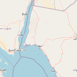
Map view of Saint Katherine Protectorate

Use this park location map to pinpoint Saint Katherine Protectorate in Egypt, understand its exact geographic position, and read its mapped placement within the surrounding landscape more clearly.

Pigeon | © OpenStreetMap contributors

Location context for Saint Katherine Protectorate

South Sinai Governorate
Park atlas

Compare the varied protected landscapes, regional park geography, and conservation areas neighboring Saint Katherine Protectorate.

Explore Protected Areas Near Saint Katherine Protectorate, Discover Sinai's Mountain Parks

After exploring Saint Katherine Protectorate, discover additional protected areas across the Sinai Peninsula, including nearby mountain parks and arid conservation landscapes. Use this geographic context to compare diverse protected ecosystems, trace regional terrain, and understand broader conservation efforts within the surrounding region.
Protected areaSouth Sinai Governorate
About 50 km away#1 closest

Southeast

Nabq Protected Area: South Sinai Governorate Protected Landscape and Regional Geography

Explore its mapped terrain and protected area context.

Nabq Protected Area offers a distinct view into Egypt's protected landscapes, situated within the South Sinai Governorate. This detailed page provides an atlas-style perspective on its geographic setting, allowing for structured exploration of its mapped boundaries and its role within the regional context. Understand the unique natural terrain and protected area characteristics that define this significant Egyptian site.

Area
600 km²
Established
1992
IUCN
VI
Relief
Mountain
National parkSouth Sinai Governorate
About 90 km away#2 closest

South

Ras Muhammad National Park: South Sinai Protected Landscape and Geographic Atlas

Discover the mapped boundaries of this Egyptian national park.

Ras Muhammad National Park is a crucial protected area within the South Sinai Governorate, offering insights into Egypt's natural landscapes. This page facilitates an atlas-style exploration of the park, highlighting its geographic significance and protected status. Users can investigate its mapped terrain and understand its context within the regional geography of the Sinai Peninsula for structured geographic discovery.

Area
480 km²
Established
1983
Relief
Mixed relief
Climate
Arid
National parkIsrael
About 239 km away#3 closest

North

Makhtesh Ramon National Park: Israel's Premier Erosion Cirque & Geological Wonder

Discover dramatic desert terrain and ancient, colorful rock formations.

Makhtesh Ramon National Park in Israel's Negev Desert is the world's largest erosion cirque, a vast 40-kilometer depression revealing millions of years of geological history. Its striking landscape features colorful clay hills, ancient volcanic remnants, fossil beds, and unique sandstone formations, making it an unparalleled destination for understanding Earth's past through its protected natural terrain. Explore the mapped boundaries and regional context of this extraordinary desert formation.

Relief
Mountain
Climate
Arid
Access
Moderate access
Scope
Terrestrial
National parkIsrael
About 261 km away#4 closest

North

Avdat National Park: A Protected National Park in Israel's Regional Geography

Mapped landscape context and protected area details for Avdat National Park.

Avdat National Park represents a distinct protected landscape entity within the atlas of Israel. This resource focuses on the park's geographic identity, its mapped boundaries, and the surrounding natural terrain. Delve into the specific protected-area attributes that define Avdat National Park and understand its contribution to the country's conservation geography, offering a grounded perspective for geographic exploration.

Climate
Arid
Scope
Terrestrial
Water
No major water
Forest
No forest cover
Watercolor illustration of a canyon with winding river, mountains, and rolling hills
National parkIsrael
About 264 km away#5 closest

North

Ein Avdat National Park: A Spectular Desert Oasis and Protected Landscape in Israel

Explore its unique springs, waterfalls, and ancient Nabatean and Byzantine history.

Ein Avdat National Park showcases a rare desert oasis environment, a starkly beautiful protected landscape where natural springs emerge from the Negev's arid terrain. This park is celebrated for its dramatic waterfalls, deep pools, and the preserved remnants of ancient human habitation, including a remarkable Byzantine cave monastery carved directly into the canyon walls. Its geography, shaped by the Nahal Zin wadi, provides a vivid study in desert ecosystems and their capacity for supporting life and history over millennia, making it a key site for understanding landscape context in Israel.

Area
4.8 km²
IUCN
V
Relief
Mixed relief
Climate
Arid
National parkIsrael
About 266 km away#6 closest

North

Shivta National Park National Park: An Atlas View of Israel's Protected Landscapes

Mapped terrain and regional geographic context for Shivta National Park.

Shivta National Park represents a key protected area, offering a focused entry into Israel's broader geographic and landscape atlas. This page provides specific details about the park's identity as a national park, its mapped terrain, and its placement within the regional context of the country. Users can explore the structured information that defines Shivta National Park's role as a protected landscape, contributing to a deeper understanding of its geographic significance and mapped features.

Climate
Arid
Access
Easy access
Scope
Terrestrial
Water
No major water
National parkIsrael
About 267 km away#7 closest

North

Ben-Gurion Tomb National Park: Protected Desert Landscape and Geographic Context

Explore the Negev Desert's unique memorial terrain.

Ben-Gurion Tomb National Park offers a distinct protected landscape experience in the heart of Israel's Negev Desert. This national park is primarily known as the burial site of David and Paula Ben-Gurion, intentionally situated in the desert overlooking the dramatic Nahal Tzin canyon. The park's approximately 90 dunams feature a carefully designed memorial garden that contrasts with the arid terrain, providing a unique focus for geographic exploration and understanding the site's regional landscape.

Area
0.09 km²
Relief
Lowland
Climate
Arid
Access
Easy access
Watercolor illustration of a mountainous landscape with multiple colored terrain layers
Biosphere reserveJordan
About 283 km away#8 closest

Northeast

Dana Biosphere Reserve: Mapped Biosphere Reserve in Jordan's Geography

Explore protected landscape boundaries and regional context.

Dana Biosphere Reserve is a critical protected landscape in Jordan, recognized for its significant geographic features and ecological value. This page offers detailed insights into its mapped boundaries and its place within the broader regional geography of the Middle East. It serves as an essential resource for understanding the park's protected-area identity and its contribution to Jordan's natural heritage, facilitating a deeper atlas-driven exploration of its terrain and conservation significance.

Area
308 km²
Established
1989
Relief
Mixed relief
Scope
Terrestrial

Common questions about visiting, size, designation, and location context for Saint Katherine Protectorate

Saint Katherine Protectorate FAQs for park facts, access, geography, and protected area context

Find quick answers about Saint Katherine Protectorate, including protected-area facts, park geography, trail and visitor context, and how the park fits into its surrounding country and regional landscape.
MoriAtlas Explorer

Continue Your Protected Areas Search Across the Global Atlas

Deepen your exploration by continuing the structured search for national parks and protected areas worldwide. Utilize the comprehensive filtering capabilities to compare different conservation landscapes and refine your understanding of global park geography. Discover more about the distribution and characteristics of protected natural areas.

Global natural geography