


Why San Francisco Bay National Estuarine Research Reserve stands out
The reserve is best known for protecting and studying some of the last remaining high-quality tidal wetlands in the San Francisco Estuary, a system that has lost the vast majority of its historic tidal wetland cover. Its two anchor sites, Rush Ranch on the edge of Suisun Marsh and China Camp on San Pablo Bay, serve as living laboratories for understanding how estuarine ecosystems function, how they respond to change, and how they can be restored. The reserve is also recognized for its collaborative model of estuary science, drawing together NOAA, San Francisco State University, Audubon, the Smithsonian, state parks, and regional conservation partners to support research on water quality, bird populations, and coastal resilience. Through these partnerships it has become a focal point for estuarine monitoring and education in the San Francisco Bay Area.
San Francisco Bay National Estuarine Research Reserve history and protected-area timeline
The San Francisco Bay National Estuarine Research Reserve has its origin in the 1990s, when Dr. Roger Crawford of San Francisco State University secured a grant from NOAA to investigate the possibility of establishing a National Estuarine Research Reserve within San Francisco Bay. The exploration phase brought together scientists and stakeholders interested in recognizing the importance of the bay's remaining tidal wetlands.
Dr. Mike Vasey was subsequently appointed to lead the formal designation process. Working with a team of scientists, Vasey and his colleagues examined where the highest-quality tidal wetland remnants of the San Francisco Estuary could still be found and how they might be incorporated into a federal-state reserve. Their work laid the foundation for the eventual structure of the reserve.
Following this planning and consultation period, the reserve was officially designated in August 2003. Since then, it has evolved into a multi-agency research and education hub, anchored at San Francisco State University's Romberg Tiburon Campus and operating across its two coastal sites. Over time, partnerships with land trusts, state and federal agencies, and scientific institutions have expanded the reserve's role in regional wetland science, coastal resilience, and community engagement.
San Francisco Bay National Estuarine Research Reserve landscape and geographic character
The reserve's landscape is shaped by the tidal wetlands of the San Francisco Estuary, one of the most distinctive estuarine systems on the Pacific coast of North America. The two reserve sites sit in different but complementary positions within this larger tidal landscape, each capturing a different expression of bay-edge terrain.
Rush Ranch Open Space Preserve occupies the northern margin of Suisun Marsh, a vast network of managed and natural wetlands in the northeastern reaches of San Francisco Bay. The reserve's lands here sit at the western foot of the Potrero Hills, transitioning from upland ridges down into broad tidal marsh flats. This area is defined by gentle gradients, extensive shallow water at high tide, exposed mudflats at low tide, and patches of pickleweed, cordgrass, and other salt-tolerant vegetation typical of estuarine systems near freshwater inflows.
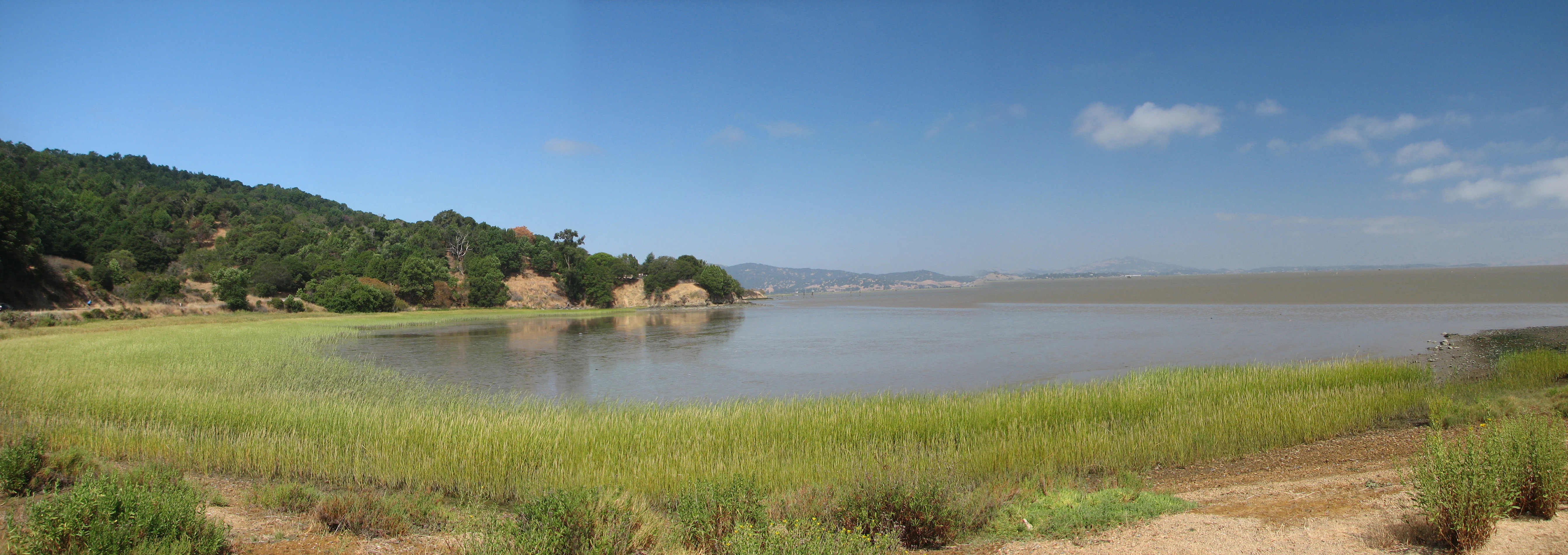
China Camp State Park, the reserve's other major site, occupies a stretch of shoreline along San Pablo Bay, one of the northern sub-embayments of San Francisco Bay. Its terrain combines tidal mudflats and salt marsh with rolling uplands, oak woodlands, and shoreline bluffs. The interplay of wetland and upland at this site creates a varied mosaic of habitats within a relatively compact area, while the bay itself provides a wide, shallow-water setting marked by strong tidal flow.
Together, the two sites embody the central physical character of the San Francisco Bay estuary: a dynamic system of shallow water, soft sediment, salt- and freshwater mixing zones, and a fragile but resilient edge between land and sea.
San Francisco Bay National Estuarine Research Reserve ecosystems, habitats, and plant life
The reserve protects core examples of tidal wetland ecosystems and the broader estuarine environment that surrounds them. These wetlands are among the last relatively intact tidal marsh systems left in the San Francisco Bay region, and they serve as a benchmark for understanding what healthy bay-edge ecosystems look like in this part of California.
Ecologically, the reserve captures habitats that span the full tidal salinity gradient. Brackish and tidal freshwater marshes are particularly prominent around the Suisun Marsh and Rush Ranch area, while salt marshes and intertidal mudflats dominate along San Pablo Bay at China Camp. Pickleweed, cordgrass, and other halophytic plants anchor the vegetation, while the wet-dry cycle of the tides drives the underlying ecological rhythm of the system.
The reserve also includes transitional upland communities, especially at its boundaries and within China Camp, where oak woodland and coastal scrub interface with the marsh. This land-to-sea transition zone is ecologically important, providing habitat for species that depend on both upland cover and tidal resources. By protecting these different elements within a single institutional framework, the reserve supports a more complete picture of estuary ecology than narrower habitat-focused sites can offer.
San Francisco Bay National Estuarine Research Reserve wildlife and species highlights
The tidal wetland and estuarine habitats protected by the reserve sustain a wide range of birdlife, fish, invertebrate communities, and other animals that depend on the rhythm of the tides. Birds are especially prominent, as San Francisco Bay sits along major migratory corridors and hosts large populations of shorebirds, waterfowl, and wading species that use its mudflats and marshes as feeding and resting habitat.
Rush Ranch and Suisun Marsh are known for attracting raptors, waterbirds, and seasonal migrants, while China Camp's shoreline and upland-edge habitats support additional bird communities and small mammals that move between forest, scrub, and wetland. Tidal mudflats around both sites are rich in invertebrates, which form the base of the food chain for fish, crabs, shorebirds, and larger predatory species.
The reserve also functions as habitat for fish species that rely on the estuary for spawning, nursery areas, or migration passage, as well as for mammals such as river otters and various bat species. Beyond individual species, the reserve is valued for sustaining the ecological interactions that define a working tidal system: predator-prey relationships, seasonal migrations, and the dependence of many species on healthy wetland vegetation.
San Francisco Bay National Estuarine Research Reserve conservation status and protection priorities
From a conservation standpoint, the San Francisco Bay National Estuarine Research Reserve represents an effort to preserve and study the ecological foundation of one of North America's most altered estuaries. The San Francisco Bay watershed has lost the great majority of its historic tidal wetlands, making the remaining intact examples both biologically valuable and scientifically irreplaceable.
The reserve contributes to conservation in several overlapping ways. Its protected sites serve as refuges for tidal marsh ecosystems and as reference points for restoration work elsewhere around the bay. Its long-term monitoring programs generate data on water quality, vegetation change, bird populations, and other ecological parameters that inform regional decision-making on habitat protection, restoration investment, and coastal resilience.
Through partnerships with entities such as the San Pablo Bay National Wildlife Refuge, Point Blue Conservation Science, the Smithsonian Environmental Research Center, Audubon, and the San Francisco Estuary Institute, the reserve extends its conservation reach beyond its own boundaries. It plays a coordinating and convening role in the bay's broader wetland conservation community, contributing to endangered species recovery, tidal restoration, and planning for the long-term resilience of the estuary in the face of sea-level rise and other environmental pressures.
San Francisco Bay National Estuarine Research Reserve cultural meaning and human context
The reserve's sites are not only ecological landscapes but also places with cultural significance. China Camp is especially notable, as the area has a long history tied to Chinese American shrimping communities and broader patterns of human settlement along San Pablo Bay. The blend of natural and cultural heritage is recognized in the management of the site, where cultural resources are considered alongside ecological ones.
More broadly, the reserve reflects the cultural identity of the San Francisco Bay Area as a region that places high value on both scientific study of its environment and active public engagement with it. Through its educational programming and its position within the public lands of the bay, the reserve contributes to a regional narrative in which estuary stewardship is part of everyday civic life, from shoreline trails to classroom research projects.
Top sights and standout views in San Francisco Bay National Estuarine Research Reserve
The reserve's most distinctive feature is its focus on tidal wetlands within a major urban estuary, an unusual combination that gives it both scientific and educational value. Its two anchor sites illustrate contrasting, ecologically significant expressions of the bay: the broad brackish marshes of Suisun and the bay-edge tidal landscape of San Pablo.
Its institutional structure is another defining strength, linking NOAA with San Francisco State University and weaving in dozens of additional partners, from Audubon to the Smithsonian, that broaden the reserve's research reach. This makes it not just a place on the map but a working hub for estuary science, monitoring, and public engagement across the Bay Area.
Best time to visit San Francisco Bay National Estuarine Research Reserve
The reserve's tidal sites are dynamic year-round, and there is no single fixed best season. Winter and early spring tend to bring the largest concentrations of migratory waterfowl and shorebirds to bay-area wetlands, making these seasons rewarding for birdwatching. Late winter and early spring can also offer cooler, quieter conditions for walking the upland trails.
Spring and fall are often comfortable for exploring shorelines, marshes, and trails, with mild temperatures and active ecological transitions. Summer brings warmer weather and drier trail conditions, but it is also a key period for understanding how tidal systems respond to heat, evaporation, and changing water levels. Choose a season based on whether your priority is birdlife, comfortable hiking weather, or interest in a specific ecological process.