
Mori Atlas logo
Nature reserveSandharlander Heide

Analyzing the botanical diversity and geological soil layers of this protected German landscape

Sandharlander Heide Nature Reserve: Geographic Context and Mapped Protected Landscapes

(Naturschutzgebiet Sandharlander Heide)

Sandharlander Heide is a significant nature reserve characterized by a complex intersection of Jurassic limestone bedrock and Pleistocene wind-blown sand. This unique site, located in the transition zone of the Jura foothills, preserves a remnant cultural landscape that supports a dense concentration of dry calcareous grasslands and specialized acidic soil habitats. Spanning roughly 25.7 hectares, the protected area offers a clear look at how micro-geology influences botanical richness and long-term conservation patterns within the region.

nature reserveheathdry grasslandcalcareous grasslandacidic soil habitatlimestone geology
A flat-style digital illustration depicting a wide mountain valley with evergreen trees, cliffs, and a small waterfall in the distance.

Sandharlander Heide

Nature reserve

Park overview

Structured park overview, official facts, and landscape profile for Sandharlander Heide

Sandharlander Heide park facts, protected area profile, and essential visitor context

Review the core facts for Sandharlander Heide, including designation, size, terrain, visitor scale, habitats, and operating context in one park-focused overview.

About Sandharlander Heide

Sandharlander Heide lies on a gentle hilltop at roughly 48.85 degrees north, on the western edge of the Hallertau hop-growing region and not far from the Danube valley upstream of Weltenburg. Although it is only a small reserve, its ecological profile is unusually complex because the underlying geology mirrors the broader transitional character of this part of Bavaria: solid Jurassic limestone, locally known as Weisser Jura or White Jura, lies close to Cretaceous sediments, and a thin veneer of Pleistocene aeolian sand was deposited across the transition zone during colder phases of the Ice Age.

Where the wind-blown sand layer is thick enough, the soil becomes acidic and nutrient-poor, favoring dry grassland communities and specialized heath-like vegetation. Where the limestone comes nearer to the surface, calcareous grasses and flowering plants dominate. Because the two regimes are interleaved within a very small area, the reserve functions almost like a living laboratory for understanding how microgeology controls plant distribution in central European landscapes.

The landform itself is a low Geländekuppe, or terrain dome, historically maintained as open ground by communal grazing. Sheep and other livestock kept the vegetation short for centuries, preventing forest succession and allowing the full expression of dry grassland flora. Once traditional grazing pressure collapsed after 1945, the site required active conservation management to retain its character, first under Bavarian nature protection law from 1970 and later as part of the European Natura 2000 network.

Quick facts and research context for Sandharlander Heide

Sandharlander Heide is a protected nature reserve (Naturschutzgebiet) and coincident FFH site in the Kelheim district of Lower Bavaria, about 2.8 kilometers northwest of Abensberg. It is classified under IUCN Category IV as a Habitat/Species Management Area and was first placed under formal protection in 1970, with subsequent reclassification and FFH designation following EU habitat directives. The reserve covers approximately 25.7 hectares on a single hilltop whose soils combine Jurassic limestone with a relict cover of Pleistocene wind-blown sand, allowing both calcareous and acidic plant communities to coexist. The area is registered in the World Database on Protected Areas and forms part of Bavaria's network of small, ecologically focused reserves on the northern edge of the Danube valley.

Protection and recognition

Review documented terrestrial protection scope and Natura 2000 listings.

Sandharlander Heide Protection Status and International Recognition Data

Sandharlander Heide maintains documented terrestrial protection status alongside verified Natura 2000 recognition records. Structured conservation data details official designation metrics and management parameters for this protected landscape.

International recognition

Protection details

Protection scope
Terrestrial
Transboundary protection
No
WDPA ID
82486
Park context

Deeper park guide and search-rich context for Sandharlander Heide

Sandharlander Heide history, landscape, wildlife, and travel context

Explore Sandharlander Heide through its history, landscape character, ecosystems, wildlife, conservation priorities, cultural context, and seasonal travel timing in a structured park guide built for atlas discovery and search intent.

Why Sandharlander Heide stands out

The reserve is best known for its Soil diversity: a thin layer of Ice Age wind-blown sand lying on top of Jurassic limestone. That single geological feature has produced a remarkable concentration of habitat types within just a few hectares, including dry calcareous grasslands (Festuco-Brometalia), mat-grass swards on silicate soils, Molinia meadows on calcareous and peaty substrates, and species-rich lowland hay meadows. More than 200 plant species have been documented on the site, making it a small but disproportionately rich botanical reference area for the southwestern Frankenalb region. The reserve also preserves an authentic cultural landscape shaped by Allmende communal grazing, abandoned mid-twentieth century and now maintained through conservation management.
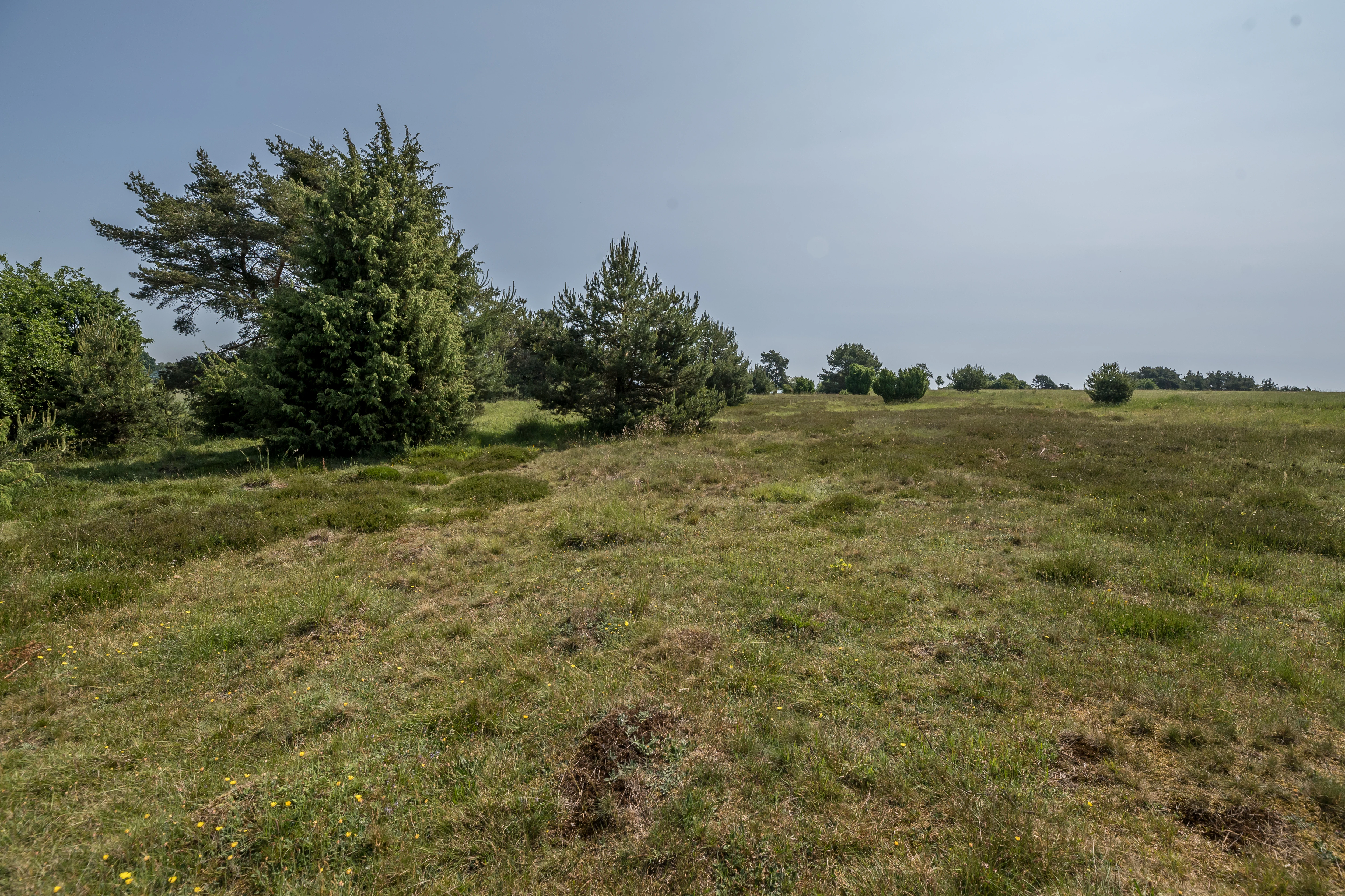
A wide view of the Sandharlander Heide nature reserve showing a grassy, open heathland with scattered small evergreen trees under a hazy sky.
Heathland landscape in the Sandharlander Heide nature reserve.

Sandharlander Heide history and protected-area timeline

The Sandharlander Heide hilltop was used as a communal Allmende pasture for centuries before 1945. Local communities shared rights to graze livestock on the open ground, a practice that sustained the short, species-rich turf characteristic of the site. With the social and agricultural changes of the mid-twentieth century, communal grazing collapsed and the heath began the slow process of ecological succession toward woodland.

In 1970, the Bavarian authorities formally designated the area as a Naturschutzgebiet, recognizing both its botanical value and its geological interest. The nature reserve boundary is identical to that of the later FFH (Fauna-Flora-Habitat) site, which integrates the area into the European Union's Natura 2000 network of protected habitats. The site is registered with the identifier NSG-00090.01 and the Natura 2000 code DE7136-302, with its global record maintained as WDPA ID 82486.

Sandharlander Heide landscape and geographic character

The reserve sits on a single rounded hilltop, a Geländekuppe, in the gently undulating country north of the Danube. The topography is mild rather than dramatic, but the small relief has been enough to shape drainage, soil depth, and exposure, producing several distinct microhabitats within a short walking distance.

Geologically, the site sits on Jurassic limestone belonging to the Weisser Jura, the uppermost subdivision of the southern German Jura sequence. Across much of this northern edge of the Jura, Cretaceous sediments were also once present. During cold phases of the Pleistocene, fine wind-blown sand was blown out of glacial outwash plains and deposited as a thin cover across the transition zone between limestone and Cretaceous rocks. Where that sand layer survives, it continues to mask the underlying calcareous bedrock, producing the acidic, nutrient-poor soils that so strongly influence the vegetation today. The interaction of these three geological elements, limestone, Cretaceous sediments, and Pleistocene sand, defines the physical character of the protected landscape.

Sandharlander Heide ecosystems, habitats, and plant life

The vegetation of Sandharlander Heide is unusually rich for its size because of the close coexistence of calcareous and acidic soils. The protected grassland communities classified under the EU Habitats Directive include near-natural dry calcareous grasslands and their shrub-encroached stages (the Festuco-Brometalia type), species-rich mat-grass swards on silicate substrates (submontane and montane mat-grass grasslands), small-reed meadows of the Molinion caeruleae type on calcareous, peaty, and clay-silt soils, and species-rich lowland hay meadows of the Alopecurus pratensis - Sanguisorba officinalis type.

On the nutrient-poor sandy soils, plants typical of heath and dry acidic grassland occur, while adjacent calcareous patches support a very different flora based on lime-loving species. Surveys have identified more than 200 plant species across the site. This mosaic of habitats within a compact area allows botanists and ecologists to study how European dry grassland communities respond to substrate chemistry, succession pressure, and conservation management over very short distances.

Sandharlander Heide wildlife and species highlights

The reserve does not have a high-profile large-mammal fauna; its ecological interest lies primarily at the level of vascular plants, grassland invertebrates, and habitat structure. Because more than 200 plant species have been documented on the site, the area also supports an associated community of pollinating insects and other grassland invertebrates typical of central European dry and semi-dry grasslands. The mosaic of calcareous and acidic habitats is generally considered favorable for invertebrates in particular, although the source pages do not give detailed species records.

Sandharlander Heide conservation status and protection priorities

Sandharlander Heide has been protected since 1970 as a Bavarian Naturschutzgebiet. The site carries IUCN Category IV status, placing it in the Habitat/Species Management Area category rather than the stricter wilderness or national park categories. This designation is appropriate because the reserve exists not as untouched wilderness but as a maintained cultural landscape, requiring active intervention to counter the natural succession toward forest that would otherwise follow the loss of historical grazing.

The reserve is also an official Fauna-Flora-Habitat site under the European Union's Habitats Directive, carrying the Natura 2000 identifier DE7136-302. Through this designation, its four protected habitat types, Festuco-Brometalia dry calcareous grasslands, silicate mat-grass swards, Molinion meadows, and species-rich Alopecurus hay meadows, are formally recognized as conservation priorities. The reserve is registered in the World Database on Protected Areas under WDPA ID 82486 and the Bavarian nature reserve register under NSG-00090.01, and forms one of multiple Natura 2000 sites within the Kelheim district.

Sandharlander Heide cultural meaning and human context

The most distinctive human story attached to Sandharlander Heide is its long history as an Allmende, a shared communal pasture. Until 1945, local villagers held collective grazing rights on the open hilltop, and that centuries-old land use is the reason the heath remained open and botanically rich rather than having reverted to forest. The collapse of that communal system in the mid-twentieth century is, in effect, the origin point of the modern conservation effort: the landscape owes its current protected status to an older, pre-modern system of shared stewardship that ended only in living memory.

Top sights and standout views in Sandharlander Heide

Within a footprint of roughly 25.7 hectares, Sandharlander Heide combines four officially protected EU habitat types, more than 200 documented plant species, and a layered geology in which Pleistocene wind-blown sand sits directly on Jurassic limestone. The reserve is a textbook example of how microgeology shapes biodiversity in central European dry grasslands, and it preserves an open cultural landscape that has effectively been maintained by grazing for centuries before being taken into formal protection.

Best time to visit Sandharlander Heide

Late spring and early summer typically offer the richest display of flowering plants on dry calcareous and acidic grasslands in this part of Bavaria, with the strongest color and insect activity in May and June. Later in summer the turf dries out and takes on the more austere, tawny character typical of central European heath and steppe-like vegetation. Visits at any time of year are feasible in this low-relief agricultural setting, although winter visits are likely to show the least botanical interest and the brownest vegetation cover.
Monthly climate preview

Long-term temperature and precipitation patterns across representative coordinates in Lower Saxony

Sandharlander Heide Climate Normals and Average Temperature Rhythms

Historical data records monthly temperature swings from sub-zero winter minimums to warm summer maximums alongside consistent daily precipitation rates at one representative park coordinate. Examining the complete twelve-month record reveals deeper patterns in long-term climate normals and regional weather variation across Sandharlander Heide.
Annual mean8 °C
-2 °C19 °C
Jan-2°
Feb-1°
Mar
Apr
May13°
Jun17°
Jul19°
Aug19°
Sep14°
Oct
Nov
Dec-1°
Warmest month
July

18.7 °C

Coolest month
January

-1.9 °C

Wettest month
June

2.8 mm/day

Driest month
April

1.4 mm/day

Park location guide

Geography guide, regional context, and park location map for Sandharlander Heide

Sandharlander Heide park geography, regions, and map view in Germany

Understand where Sandharlander Heide sits in Germany through a broader geographic reading of the surrounding landscape, nearby location context, and its mapped position within the national park landscape.

How Sandharlander Heide fits into Germany

Germany is a federal republic in Western and Central Europe with a population of over 83 million across sixteen constituent states. It is Europe's largest economy by nominal GDP and a major global exporter and importer. The capital is Berlin, and the country borders Denmark, Poland, Czech Republic, Austria, Switzerland, France, Luxembourg, Belgium, and the Netherlands.

Wider geography shaping Sandharlander Heide in Germany

Germany is located in Western and Central Europe, spanning 357,022 km². It borders Denmark to the north, Poland and the Czech Republic to the east, Austria and Switzerland to the south, and France, Luxembourg, Belgium, and the Netherlands to the west. The country has coastlines on the Baltic Sea and North Sea to the north, with the Alps located in the southern region.

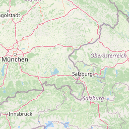
Map view of Sandharlander Heide

Use this park location map to pinpoint Sandharlander Heide in Germany, understand its exact geographic position, and read its mapped placement within the surrounding landscape more clearly.

Pigeon | © OpenStreetMap contributors

Location context for Sandharlander Heide

Lower Saxony

Visual reference guide to rare dry grasslands, sandy soils, and hilltop heath terrain

Sandharlander Heide Landscape Photos and Protected Area Scenery

Visual records capture the distinctive topography, sandy soils, and rare calcareous vegetation defining Sandharlander Heide. Detailed photography reveals how Ice Age wind-blown sand overlays Jurassic limestone to shape unique habitat mosaics across the reserve.

A wide view of the Sandharlander Heide nature reserve showing a grassy, open heathland with scattered small evergreen trees under a hazy sky.

Park atlas

Compare regional protected areas, surrounding terrain, and adjacent nature reserves.

Explore Other Parks Near Sandharlander Heide and Connected Protected Landscapes

Browse protected areas and natural reserves located near Sandharlander Heide to compare regional topography and habitat types. Evaluating adjacent conservation landscapes provides broader context on the Jura foothills and local geological transitions.
Nature reserveLandkreis Eichstätt
About 51 km away#1 closest

West

Naturwaldreservat Tucherwald: Protected Karst Forest Landscape in Landkreis Eichstätt

A study in non-intervention woodland and natural forest dynamics

Naturwaldreservat Tucherwald preserves a diverse mosaic of beech, oak, and linden forest on the steep, limestone slopes of the southern Frankenalb. This protected area offers insight into unmanaged forest succession, standing deadwood habitats, and the unique microclimates found within the Wellheim Dry Valley regional geography.

Area
0.541 km²
Established
1998
Relief
Upland
Scope
Terrestrial
A watercolor illustration showing rolling green hills, small clusters of trees, and a distant forested ridgeline against a soft sky.
Protected landscapeBavaria
About 57 km away#2 closest

North

Naturpark Hirschwald: A Protected Landscape and Geographic Overview in Bavaria, Germany

Calcareous dry grassland habitats and regional forest mosaic

Naturpark Hirschwald is a compact, mosaic-like protected landscape located in Bavaria. The park integrates the Lauterach valley, sun-exposed limestone slopes, and juniper-rich heathlands. Recognized for its critical role in bat conservation and diverse regional terrain, it provides a clear example of the ecological transition between the Franconian Alb and northern Upper Palatinate forests.

Area
277.6 km²
Established
2006
Relief
Upland
Climate
Temperate
Nature reserveWeißenburg-Gunzenhausen
64 km away#3 closest

West

Schambachried: Protected Calcareous Fen and Wetland Geography in Weißenburg-Gunzenhausen

Historic nature reserve marking the karst and valley transition

Schambachried preserves a rare calcareous lowland fen within the Treuchtlingen Pforte of Bavaria. As the oldest nature reserve in Middle Franconia, this protected area offers a concentrated study of botanical diversity at the meeting point of the Weißenburger Alb limestone plateau and the Schambach valley stream system.

Area
0.069 km²
Established
1973
IUCN
IV
Relief
Lowland
A horizontal watercolor painting depicting a soft, stylized landscape with rolling green hills, distant purple mountain ridges, and sparse clusters of trees against a light background.
Nature reserveBayern
About 68 km away#4 closest

North

Rinntal bei Alfeld Nature Reserve: Geographic Profile and Protected Valley Landscape

A preserved limestone dry valley in the Franconian Jura of Bayern

Rinntal bei Alfeld is a significant nature reserve covering 34 hectares of dry valley landscape. Its geography includes abandoned field terraces, juniper-framed slopes, and rocky dolomite outcrops. As part of the Natura 2000 Bachtäler der Hersbrucker Alb network, the reserve showcases the traditional grazing influence and limestone karst features of the Franconian Jura plateau.

Area
0.338 km²
Established
2000
IUCN
IV
Relief
Upland
A pale, soft-toned watercolor painting showing a wetland scene with grass, trees, and distant hills.
Nature reserveNürnberger Land
About 70 km away#5 closest

Northwest

Schwarzenbrucker Moor Nature Reserve: Geography and Protected Wetland Boundaries

A rare peatland habitat in the Middle Franconian landscape.

Schwarzenbrucker Moor is a preserved wetland complex situated within a bowl shaped former river meander. This nature reserve sustains a dense mosaic of open water, reedbeds, and alder bog woodland. Examine the site geography, mapped boundaries, and environmental significance of this protected habitat within the Nürnberger Land district.

Area
0.1 km²
Established
1992
IUCN
IV
Relief
Lowland
A horizontal watercolor illustration showing a winding stream moving through a flat marshy landscape with scattered trees and distant rolling hills.
Nature reserveBavaria
About 71 km away#6 closest

South

Schwarzhölzl Nature Reserve: Protected Lowland Peatland and Forest Geography in Bavaria

Essential protected area map and habitat overview

Schwarzhölzl is a specialized nature reserve in Bavaria protecting a rare mosaic of peat birch forest, bog pines, and wet meadows. As an ecological remnant of the vast Dachauer Moos, this site provides a deep look into the lowland wetland terrain and the specific conservation landscape managed within the Munich green belt. Explore the mapped boundaries and structural geography of this significant protected lowland site.

Area
0.795 km²
Established
1994
Relief
Lowland
Climate
Temperate
A soft, light-toned watercolor illustration of a river landscape with rolling hills in the background and a lone tree in the foreground.
Nature reserveBavaria
About 71 km away#7 closest

Northwest

Schwarzachschlucht Nature Reserve: Geographic Map and Protected Landscape Overview in Bavaria

A study of Franconian sandstone topography and riverine protected habitats

Schwarzachschlucht provides a focused example of geological erosion and forest conservation in Bavaria. This nature reserve features distinctive honeycomb-weathered cliffs, deep river-carved channels, and a significant moss-rich microclimate that has been protected since 1936. The site serves as a vital case for observing the transition between mixed forest slopes and alder-lined riverbanks within the Nürnberger Land district.

Area
0.38 km²
Established
1936
IUCN
IV
Relief
Upland
Watercolor painting of a light and airy landscape featuring green rolling hills, a cluster of trees, and wildflowers in the foreground against a pale sky.
Nature reserveBavaria
About 71 km away#8 closest

North

Schottental bei Heldmannsberg Nature Reserve: Mapped Geography and Protected Valley Landscapes

A diverse karst valley reserve in the Middle Franconia region of Bavaria.

Located in the Nürnberger Land district of Bavaria, Schottental bei Heldmannsberg is a nature reserve that protects a narrow, limestone-walled side valley. The site offers a detailed look at dolomite cliff faces, hydrologically active karst spring pools, and a mosaic of calcareous dry grasslands and beech-pine woodland. This atlas entry provides insight into its geological features, including the notable Bärenfels outcrop, and its role in preserving traditional Hutanger grazing habitats within the Hersbrucker Alb.

Area
0.415 km²
Established
1996
IUCN
IV
Relief
Upland

Common questions about visiting, size, designation, and location context for Sandharlander Heide

Sandharlander Heide FAQs for park facts, access, geography, and protected area context

Find quick answers about Sandharlander Heide, including protected-area facts, park geography, trail and visitor context, and how the park fits into its surrounding country and regional landscape.
MoriAtlas Explorer

Continue Your Protected Areas Search Across the Global Atlas

Deepen your exploration by continuing the structured search for national parks and protected areas worldwide. Utilize the comprehensive filtering capabilities to compare different conservation landscapes and refine your understanding of global park geography. Discover more about the distribution and characteristics of protected natural areas.

Global natural geography