

Mori Atlas logo
Protected areaSerranía de Incahuasi

Analyzing the transitional foothill terrain, watershed features, and community-managed boundaries of this Andean-Chaco ecosystem.

Serranía de Incahuasi: Comprehensive Map, Geography, and Protected Landscape Overview in Chuquisaca, Bolivia

(Área Natural de Manejo Integrado y Gestión Comunitaria del Agua y Biodiversidad Serranía de Incahuasi)

Serranía de Incahuasi occupies a vital transitional geography between the eastern Andes and the Chaco lowlands of southern Bolivia. This protected landscape spans an elevation gradient from 800 to 2,000 meters, creating a diverse topographical setting where montane forests, dry inter-Andean valleys, and Chaco scrub converge. The area functions as a community-managed space, with integrated management strategies focused on water resource stewardship and biodiversity conservation across nearly 29,000 hectares of rugged terrain.

Andean foothillsChaco Serranocommunity-managed protected areaintegrated management areawatershed conservationdry forest

Serranía de Incahuasi

Protected area

Park overview

Structured park overview, official facts, and landscape profile for Serranía de Incahuasi

Serranía de Incahuasi park facts, protected area profile, and essential visitor context

Review the core facts for Serranía de Incahuasi, including designation, size, terrain, visitor scale, habitats, and operating context in one park-focused overview.

About Serranía de Incahuasi

Serranía de Incahuasi occupies a meaningful place in Bolivia's network of community-governed protected areas. Situated in the Chuquisaca Department and administered under the municipality of Villa Vaca Guzmán, it is recognized under the formal title Área Natural de Manejo Integrado y Gestión Comunitaria del Agua y Biodiversidad Serranía de Incahuasi. Rather than functioning as a strictly enforced national park in the traditional sense, the area operates as an integrated management zone, allowing compatible land use alongside conservation goals. This approach reflects a growing recognition in Bolivia that protecting watersheds and biodiversity in transitional Andean landscapes often depends on the participation of the rural and indigenous communities who live within them.

The protected area lies within a transitional belt between the eastern Andes and the lowlands of the Gran Chaco, a position that gives it particular ecological value. Its topography descends from higher Andean foothill ridges down into warmer, drier valleys, producing a mosaic of habitats over its roughly 29,000 hectares. Elevation within the Serranía ranges from about 804 meters to around 1,986 meters, creating conditions where cloud-affected upper slopes, dry inter-Andean forest, and Chaco-type vegetation coexist across relatively short distances.

Communities such as Ity, Sapiranguimiri, and Overa Ñancahuazú live within the area, along with eight community-based organizations that participate in its management. This community dimension is central to the area's identity. The legal designation explicitly acknowledges the role of local people in conserving water sources and biodiversity, framing protection as a shared responsibility rather than a top-down reserve system. Management therefore extends beyond habitat preservation to include the maintenance of water sources that sustain both local livelihoods and downstream ecosystems.

Quick facts and research context for Serranía de Incahuasi

Serranía de Incahuasi is located in Chuquisaca Department, Bolivia, within the municipality of Villa Vaca Guzmán. It is classified as an Área Natural de Manejo Integrado and Gestión Comunitaria del Agua y Biodiversidad, a designation that combines biodiversity protection with community water stewardship. The area covers roughly 29,000 hectares and spans elevations from about 804 to 1,986 meters, placing it within the Andean foothills and the transition toward the Chaco.

Its ecological setting corresponds to the Boliviano-Tucumano and Chaco Serrano ecorregions. It is legally established by Municipal Autonomy Law N° 103/2021, dated March 31, 2021. Eight community social organizations, along with villages such as Ity, Sapiranguimiri, and Overa Ñancahuazú, participate in its governance.

Protection and recognition

Examine the official terrestrial protection metrics and international recognition records.

Serranía de Incahuasi Protection Status and Regional Conservation Scope

Serranía de Incahuasi features a documented terrestrial protection scope and assigned conservation parameters within the global database. Review the official protected area designation history and recognized international status details.

Protection details

Protection scope
Terrestrial
Transboundary protection
No
Park context

Deeper park guide and search-rich context for Serranía de Incahuasi

Serranía de Incahuasi history, landscape, wildlife, and travel context

Explore Serranía de Incahuasi through its history, landscape character, ecosystems, wildlife, conservation priorities, cultural context, and seasonal travel timing in a structured park guide built for atlas discovery and search intent.

Why Serranía de Incahuasi stands out

Serranía de Incahuasi is best known for being a community-managed protected area that blends biodiversity conservation with traditional stewardship of water resources. Its elevation gradient, ranging from low foothills into mid-mountain slopes, supports a mix of Andean and Chaco-influenced habitats, which in turn sustain species such as the Andean condor, the spectacled bear, several wild cats, and regionally important amphibians and reptiles.
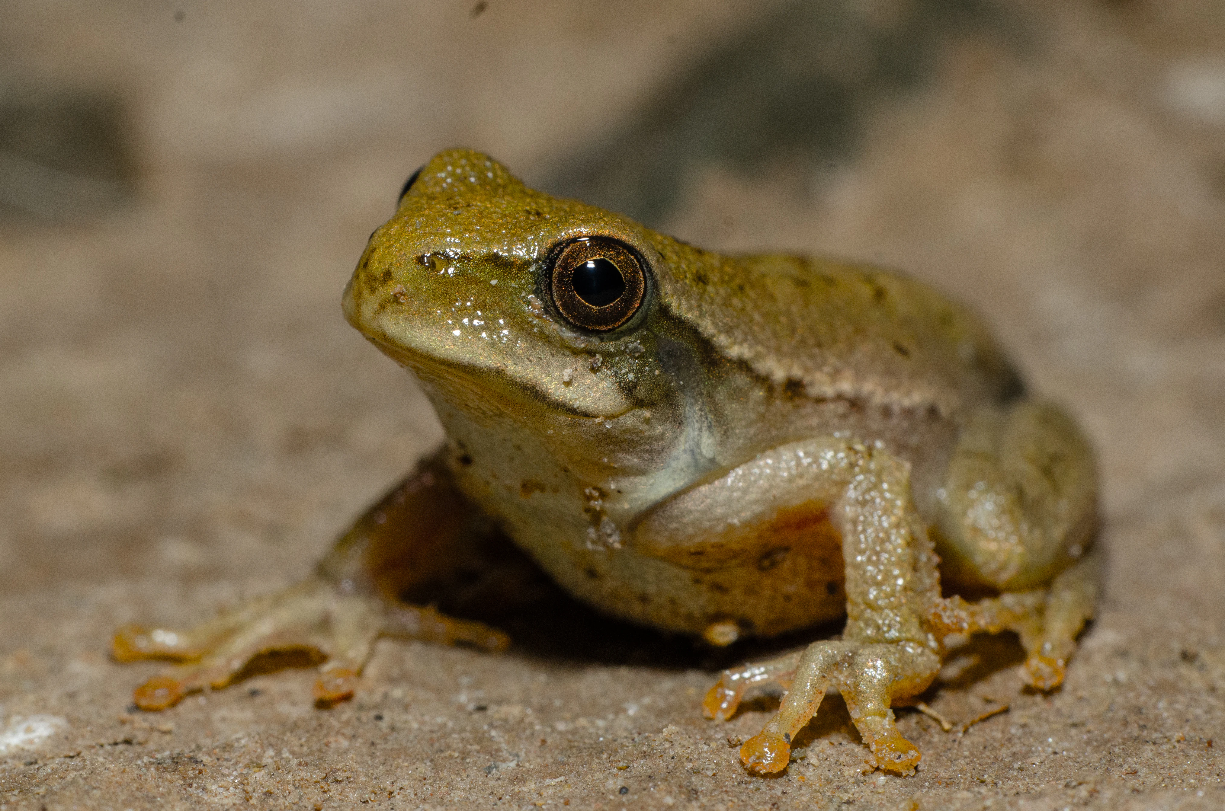
A small brownish tree frog with large dark eyes perched on a textured, sandy surface.
A Boana riojana tree frog documented in the Serranía de Incahuasi region.

Serranía de Incahuasi history and protected-area timeline

The Serranía de Incahuasi was formally established as an Área Natural de Manejo Integrado y Gestión Comunitaria del Agua y Biodiversidad through Municipal Autonomy Law N° 103/2021, dated March 31, 2021. This municipal legal framework reflects the autonomy granted to Bolivian local governments and signals the role of community-based governance in the area's creation. The designation as an integrated management area, rather than a stricter protected category, indicates that conservation, sustainable use, and community stewardship have been entwined from the start of its formal existence.

Serranía de Incahuasi landscape and geographic character

The landscape of Serranía de Incahuasi is shaped by the transition between the eastern Andes and the Chaco lowlands. Its ridges and foothills rise from roughly 800 meters to nearly 2,000 meters, producing a varied topography that mixes steep slopes, narrow valleys, and lower foothill benches. Because this elevation gradient spans such different climatic zones, scenery shifts over relatively short distances, with cooler, moister upper elevations giving way to drier, warmer slopes as the land descends toward the Chaco.

This rugged foothill setting is typical of the Boliviano-Tucumano transition, where montane forest elements blend with dry woodland and scrub. Drainage patterns in the Serranía are closely tied to this topography, with rainfall captured on higher slopes feeding streams that flow through the valleys and into surrounding lowlands. The combination of elevation, slope, and the close link between upland landscapes and downstream water sources is a defining feature of the area's physical geography.

Serranía de Incahuasi ecosystems, habitats, and plant life

Ecologically, Serranía de Incahuasi belongs to the Boliviano-Tucumano and Chaco Serrano ecoregions, which places it at the meeting point between Andean montane ecosystems and dry lowland vegetation. This dual identity produces a habitat mosaic in which species and vegetation communities typical of the eastern Andes overlap with those adapted to the drier conditions that dominate farther east.

The vegetation reflects those overlapping influences. Higher and moister areas support tree species such as aliso (Alnus acuminata), pino del cerro (Podocarpus parlatorei), and queñua (Polylepis), along with flowering trees like the lapacho (Tabebuia). Lower and drier zones include Chaco Serrano woodland components, with vegetation adapted to seasonal aridity. Together these vegetation zones create ecological gradients that support a wide range of insects, amphibians, reptiles, birds, and mammals adapted to differing moisture regimes within a single protected landscape.

Serranía de Incahuasi wildlife and species highlights

The wildlife of Serranía de Incahuasi is shaped by the area's position at the Andean–Chaco transition, which allows species typical of both ecosystems to coexist. Among mammals, the area is notable for the presence of the spectacled bear (Tremarctos ornatus), a species strongly associated with Andean forests and considered a conservation priority in Bolivia. The area also supports several wild cats, including the puma (Puma concolor) and smaller felids such as the margay (Leopardus wiedii), the little spotted cat (Leopardus tigrinus), the ocelot (Leopardus pardalis), and Geoffroy's cat (Leopardus geoffroyi).

Birdlife in the Serranía includes high-profile Andean species such as the Andean condor (Vultur gryphus), alongside regionally important species like the Tucuman amazon (Amazona tucumana), the violet-bellied hummingbird (Eriocnemis glaucopoides), and the white-throated antpitta (Grallaria albigula). Reptiles are represented by lizards such as Stenocercus roseiventris and Tropidurus melanopleurus, and by snakes including Bothrops jonathani. Amphibians recorded in the area include Boana riojana, Rhinella arenarum, Leptodactylus chaquensis, and Physalaemus albonotatus, which together reflect the importance of seasonal moisture and water sources in sustaining the area's herpetofauna.

Serranía de Incahuasi conservation status and protection priorities

Serranía de Incahuasi is significant from a conservation standpoint because it protects an ecologically transitional landscape that is increasingly threatened by land-use pressure in the Bolivian foothills. By combining biodiversity conservation with the protection of water sources, its integrated management design acknowledges that the ecological value of the area extends beyond its wildlife to include the watershed functions that sustain both local communities and downstream environments.

The area's elevation span and its location at the boundary between Andean and Chaco ecosystems make it a useful reservoir of biodiversity, including wide-ranging species such as the spectacled bear and Andean condor that require large, ecologically varied habitats. Community-based governance, built into the area's legal framework, is also a conservation asset, since effective stewardship of foothills and water sources in this region depends heavily on the engagement of the rural and indigenous populations living within and around the Serranía.

Serranía de Incahuasi cultural meaning and human context

The cultural dimension of Serranía de Incahuasi is closely tied to the rural and indigenous communities that inhabit it. Villages such as Ity, Sapiranguimiri, and Overa Ñancahuazú, along with eight community social organizations, are part of the area's governance structure. This community presence is not incidental to the protected area's identity but central to it, since the legal framework explicitly recognizes the role of community organizations in managing water and biodiversity. The Serranía thus reflects a model in which Andean and Chaco-transition landscapes are conserved together with, rather than separated from, the rural livelihoods that depend on them.

Top sights and standout views in Serranía de Incahuasi

Serranía de Incahuasi stands out for combining ecological diversity with community-led conservation. Its roughly 29,000 hectares span a steep elevation gradient that unites Boliviano-Tucumano and Chaco Serrano habitats in a single protected landscape. Notable features include the presence of the spectacled bear, several wild cat species, and the Andean condor, alongside distinctive regional species such as the Tucuman amazon and the violet-bellied hummingbird. Equally distinctive is the area's legally recognized model of integrated management of water and biodiversity, which places eight community organizations at the center of conservation decision-making.

Best time to visit Serranía de Incahuasi

The seasonal character of Serranía de Incahuasi is shaped by the climate of the Andean foothills and the Chaco transition, where wet and dry periods strongly influence vegetation, water availability, and wildlife activity. Visiting during the wet season tends to bring greener vegetation, more active amphibians and reptiles, and fuller streams in the higher valleys, while the dry season offers clearer skies and more open visibility, which can be favorable for observing birds and large mammals across the foothills. Travelers drawn to Andean condors, parrots, and seasonal water sources may find the cooler months particularly rewarding, when wildlife concentrates near remaining water and the landscape is at its most scenically defined.

Park location guide

Geography guide, regional context, and park location map for Serranía de Incahuasi

Serranía de Incahuasi park geography, regions, and map view in Bolivia

Understand where Serranía de Incahuasi sits in Bolivia through a broader geographic reading of the surrounding landscape, nearby location context, and its mapped position within the national park landscape.

How Serranía de Incahuasi fits into Bolivia

Bolivia, officially the Plurinational State of Bolivia, is a landlocked country in central South America. It features diverse geography including the Andean mountain range, Amazonian plains, Gran Chaco, and the Pantanal wetland. The country has a population of approximately 11.4 million and is administratively divided into nine departments, with La Paz as the seat of government and Sucre as the constitutional capital.

Wider geography shaping Serranía de Incahuasi in Bolivia

Bolivia is located in central South America, bordered by Brazil to the north and east, Paraguay to the southeast, Argentina to the south, Chile to the southwest, and Peru to the west. The country is divided between a western Andean region and tropical lowlands to the east and north. It includes the Amazonian plain, Gran Chaco, temperate valleys, the high-altitude Altiplano plateau, and part of the Pantanal wetland along its eastern border.

Location context for Serranía de Incahuasi

Chuquisaca

Explore protected area terrain, rugged mountain ridges, and transitional ecoregions.

Serranía de Incahuasi Photos and Landscape Scenery Visual Guide

Visual documentation of Serranía de Incahuasi reveals the rugged topography spanning from Andean foothills to Chaco scrublands. Examining these protected area landscapes helps researchers and visitors understand the complex environmental gradients and montane habitats of southern Bolivia.

A small brownish tree frog with large dark eyes perched on a textured, sandy surface.

Common questions about visiting, size, designation, and location context for Serranía de Incahuasi

Serranía de Incahuasi FAQs for park facts, access, geography, and protected area context

Find quick answers about Serranía de Incahuasi, including protected-area facts, park geography, trail and visitor context, and how the park fits into its surrounding country and regional landscape.
MoriAtlas Explorer

Continue Your Protected Areas Search Across the Global Atlas

Deepen your exploration by continuing the structured search for national parks and protected areas worldwide. Utilize the comprehensive filtering capabilities to compare different conservation landscapes and refine your understanding of global park geography. Discover more about the distribution and characteristics of protected natural areas.

Global natural geography