Mori Atlas logo
National parkShivta National Park

Understanding the geographic context and protected terrain of Shivta National Park.

Shivta National Park National Park: Mapped Boundaries and Protected Landscape Identity in Israel

Shivta National Park stands as a significant protected area within Israel, offering a unique lens through which to explore the nation's diverse geography and mapped landscapes. This dedicated space focuses on the park's identity as a protected natural entity, detailing its position within the country's atlas of conservation areas and highlighting its contribution to regional landscape understanding. Discover the mapped boundaries and the inherent geographic context that define Shivta National Park as a distinct element of Israel's natural heritage.

Archaeological SiteUNESCO World Heritage SiteByzantine RuinsDesert LandscapeAncient ChurchesNabataean Heritage

Shivta National Park

National park

Park overview

Structured park overview, official facts, and landscape profile for Shivta National Park

Shivta National Park park facts, protected area profile, and essential visitor context

Review the core facts for Shivta National Park, including designation, size, terrain, visitor scale, habitats, and operating context in one park-focused overview.

About Shivta National Park

Shivta National Park encompasses the archaeological remains of an ancient desert city that represents a remarkable chapter in the history of the Negev Desert. The site was originally known as Sobata in Greek and Subeita in Arabic, with the modern Hebrew name Shivta being a Hebraization assigned by the Negev Naming Committee in the early 1950s. While traditionally considered a Nabataean town on the ancient spice route, current archaeological interpretation suggests the settlement may have been primarily a Byzantine agricultural colony and way station for pilgrims traveling to Saint Catherine's Monastery in the Sinai. The most significant architectural remnants date to the Byzantine period, including a main church and two smaller churches, wine production facilities, residential areas, and administrative buildings. The settlement's prosperity was built on sophisticated water collection systems that captured surface runoff in large reservoirs, enabling agriculture in one of the most arid regions of the Near East. Visitors to the park today can explore the ruins of this ancient city, walking among the remains of churches with their intricate mosaic floors and the foundations of what was once a thriving desert community.

Quick facts and research context for Shivta National Park

Shivta is an archaeological national park in the Negev Desert, designated a UNESCO World Heritage Site in 2005 as part of the Incense Route - Desert Cities in the Negev. The site features ruins dating primarily from the Byzantine period (4th-7th century CE), including three churches, wine presses capable of producing approximately two million liters of wine, and well-preserved residential architecture. The settlement was abandoned in the 8th or 9th century CE after centuries of prosperity as a center of wine production and agricultural settlement in the desert. Modern research using experimental archaeology has reconstructed Nabatean farming techniques to understand how ancient inhabitants sustained agriculture in this arid environment.

Protection and recognition

Analyzing the official terrestrial boundaries and documented reserve designation details

Shivta National Park Protection Status and Conservation Geography

Factual research on terrestrial protected areas requires clear verification of official designation limits and documented management frameworks. Reviewing the documented terrestrial status of Shivta National Park supports precise geographic analysis of regional conservation efforts and reserve management.

Protection details

Protection scope
Terrestrial
Park context

Deeper park guide and search-rich context for Shivta National Park

Shivta National Park history, landscape, wildlife, and travel context

Explore Shivta National Park through its history, landscape character, ecosystems, wildlife, conservation priorities, cultural context, and seasonal travel timing in a structured park guide built for atlas discovery and search intent.

Why Shivta National Park stands out

Shivta is best known for its exceptionally well-preserved Byzantine-era churches, particularly the southern church featuring traces of a mural depicting Christ's transfiguration and colorful 6th-century mosaic work. The site is equally notable for its industrial-scale wine production, with archaeological evidence showing the settlement produced approximately two million liters of wine during its peak period, serving as a major supplier of the famous Gaza wine trade throughout Europe and the Middle East. The three churches, two wine-presses, and extensive residential areas provide one of the most complete pictures of Byzantine desert settlement life in the region.

Shivta National Park history and protected-area timeline

The history of Shivta spans several centuries of occupation and abandonment. Roman-period ruins from the first century BCE have been discovered in the southern part of the town, though most surviving structures date to the Byzantine period. The settlement reached its peak during the 4th through 6th centuries CE, when it became a significant center of wine production for the so-called vinum Gazentum (Gaza wine) trade. Archaeological evidence from trash mounds shows a dramatic increase in grape production during this period, coinciding with high demand throughout Europe and the Middle East. However, the mid-6th century brought catastrophic events including the Late Antique Little Ice Age (536-545), caused by massive volcanic eruptions, and the first outbreak of bubonic plague in the Old World (the Justinianic Plague). These events nearly halted international trade in luxury goods, causing grape production to decline and returning the settlement to subsistence farming focused on barley and wheat. The site was finally abandoned in the 8th or 9th century CE following the Arab conquest. Archaeological exploration at Shivta began in 1805 when Ulrich Jasper Seetzen became the first Westerner to visit the site, though he misidentified it as Abde (Avdat). Major excavations were conducted by Harris Dunscombe Colt in 1933-1938, though much of the findings were lost in a fire in 1938. Subsequent research by scholars including Nelson Glueck, Michael Avi-Yonah, and Michael Evenari (who pioneered experimental archaeology at the site) has provided crucial insights into ancient desert agriculture.

Shivta National Park landscape and geographic character

The landscape of Shivta National Park is defined by the harsh yet beautiful terrain of the Negev Desert. The ancient city sits on a series of shallow wadis and slopes where the ruins are scattered across a relatively flat area with minimal topographic relief. The surrounding terrain consists of the characteristic tan and ochre-colored sandstone and limestone formations typical of the southern Israeli desert. The landscape is punctuated by the remnants of ancient water collection systems including runoff channels and large reservoirs that were engineered to capture the rare desert rains and direct them to agricultural areas. The ruins themselves, though now in various states of collapse, still convey the layout of the ancient settlement with church foundations, building foundations, and wine press installations visible across the site. The desert environment creates a striking contrast between the muted earth tones of the landscape and the occasional fragments of colorful mosaic that survive in the church ruins.

Shivta National Park ecosystems, habitats, and plant life

The nature of Shivta is fundamentally shaped by its location in one of the most arid regions of Israel. The Negev Desert receives very limited rainfall, making natural vegetation sparse and largely confined to wadi beds and areas where water collects. The ancient inhabitants developed sophisticated agricultural techniques including irrigation systems, flash flood management, and water storage that allowed them to cultivate crops in this challenging environment. Modern botanical research, notably conducted by Michael Evenari in the 1960s, studied these ancient methods through experimental archaeology, reconstructing Nabatean farms to understand how desert agriculture was possible. The surrounding desert supports only drought-adapted plant species, and the park's primary ecological value lies in preserving the archaeological landscape rather than significant natural habitat. The park sits within a broader desert ecosystem that supports limited but specialized wildlife adapted to arid conditions.

Shivta National Park wildlife and species highlights

Wildlife at Shivta National Park is limited due to the extreme arid conditions of the Negev Desert. The harsh desert environment supports only species specifically adapted to survive with minimal water and extreme temperature variations. Small mammals such as various rodent species, desert rodents, and occasional fox sightings may occur, though the site itself, being an archaeological ruin rather than a natural habitat, does not support significant wildlife populations. The park's ecological significance derives from its archaeological and cultural heritage rather than biodiversity, as the desert environment simply cannot support the diverse wildlife found in more temperate or wetter regions of Israel.

Shivta National Park conservation status and protection priorities

Shivta National Park serves as a critical conservation entity for preserving one of the most important archaeological landscapes in the Negev Desert. The site was designated as a national park to protect the extensive ruins from natural erosion and human damage, while making them accessible for public education and appreciation. The UNESCO World Heritage designation in 2005 added international protection under the Convention concerning the Protection of the World Cultural and Natural Heritage, recognizing Shivta as a site of outstanding universal value. Conservation efforts have included stabilization of standing structures, documentation of architectural features, and management of visitor access to prevent damage to fragile remains. The site's inclusion in the Incense Route - Desert Cities in the Negev World Heritage listing also brings additional resources and international attention to ongoing preservation needs.

Shivta National Park cultural meaning and human context

Shivta sits within the broader cultural landscape of the Negev Desert, a region that was home to Nabataean, Roman, Byzantine, and later Islamic civilizations. The site represents a key node in the networks of trade, pilgrimage, and cultural exchange that connected the Mediterranean world with the Arabian Peninsula and beyond. As part of the Incense Route, Shivta was connected to the great trading networks that moved luxury goods including frankincense, myrrh, and spices from southern Arabia to Mediterranean markets. The Byzantine churches at Shivta also reflect the spread of Christianity into the desert regions during late antiquity, with the settlement potentially serving as a way station for pilgrims heading to Saint Catherine's Monastery in the Sinai. The site's Armenian graffito, dated to the 9th-11th centuries and found in the apse of the southern church, provides evidence of continued interest in the site even after its abandonment.

Top sights and standout views in Shivta National Park

The highlights of Shivta National Park include the remarkably well-preserved Byzantine churches, particularly the southern church with its rare beardless depiction of Jesus and traces of mural depicting Christ's transfiguration. The wine production facilities represent another major highlight, offering tangible evidence of the industrial scale of ancient wine production in the desert. The overall completeness of the archaeological site, with its churches, residential areas, administrative buildings, and agricultural installations all in close proximity, provides visitors with a comprehensive picture of Byzantine desert settlement life. The site's UNESCO World Heritage status underscores its global significance as part of the Incense Route network.

Best time to visit Shivta National Park

The best time to visit Shivta National Park is during the cooler months of late autumn through early spring, typically from October through April, when temperatures in the Negev Desert are more comfortable for exploring the outdoor archaeological site. Summer temperatures in the desert can be extremely high, making extended visits uncomfortable and potentially dangerous. Winter and spring visits offer the added benefit of potentially seeing the desert in bloom, with occasional wildflowers appearing after rainfall. Early morning visits are recommended to avoid the hottest part of the day and to experience the site in the soft morning light, which is particularly beautiful for photography among the ancient ruins.
Monthly climate preview

Long term average temperature and monthly precipitation patterns across representative terrain

Shivta National Park Climate Normals and Annual Temperature Rhythm

Representative coordinates document sustained thermal variation alongside low recorded precipitation across the measured baseline period. Detailed monthly comparisons provide complete baseline records for structured climatological analysis.
Annual mean20 °C
11 °C27 °C
Jan11°
Feb12°
Mar15°
Apr19°
May23°
Jun25°
Jul27°
Aug27°
Sep25°
Oct23°
Nov18°
Dec13°
Warmest month
August

27.1 °C

Coolest month
January

11.2 °C

Wettest month
January

1.1 mm/day

Driest month
August

0 mm/day

Park location guide

Geography guide, regional context, and park location map for Shivta National Park

Shivta National Park park geography, regions, and map view in Israel

Understand where Shivta National Park sits in Israel through a broader geographic reading of the surrounding landscape, nearby location context, and its mapped position within the national park landscape.

How Shivta National Park fits into Israel

Israel is a parliamentary republic in the Southern Levant, established in 1948 as a Jewish homeland. It borders Lebanon, Syria, Jordan, and Egypt, with Mediterranean coastline and access to the Red Sea. Jerusalem is the capital, though its status is contested, while Tel Aviv is the largest urban area. The country has a high-income economy with strong technology and innovation sectors.

Wider geography shaping Shivta National Park in Israel

Israel occupies the Southern Levant region of West Asia. It is bordered by Lebanon to the north, Syria to the northeast, Jordan to the east, and Egypt to the southwest. The western coast lies on the Mediterranean Sea, while the southern tip reaches the Red Sea. The eastern border includes the Dead Sea, Earth's lowest point. The country occupies the West Bank, Gaza Strip, and Golan Heights.

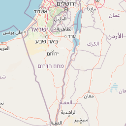
Map view of Shivta National Park

Use this park location map to pinpoint Shivta National Park in Israel, understand its exact geographic position, and read its mapped placement within the surrounding landscape more clearly.

Pigeon | © OpenStreetMap contributors

Location context for Shivta National Park

Negev
Park atlas

Compare protected landscapes across the Negev Desert region, mapping geographic connections beyond Shivta National Park's ancient ruins.

Explore Nearby National Parks and Protected Areas: Expanding Your Discovery from Shivta National Park

Browse a curated list of national parks and significant protected areas located in the vicinity of Shivta National Park, tracing the broader landscape of the Negev Desert. Compare archaeological sites, desert environments, and historical parks to understand their regional spread and diverse conservation landscapes.
Watercolor illustration of a canyon with winding river, mountains, and rolling hills
National parkIsrael
About 14 km away#1 closest

Southeast

Ein Avdat National Park: A Spectular Desert Oasis and Protected Landscape in Israel

Explore its unique springs, waterfalls, and ancient Nabatean and Byzantine history.

Ein Avdat National Park showcases a rare desert oasis environment, a starkly beautiful protected landscape where natural springs emerge from the Negev's arid terrain. This park is celebrated for its dramatic waterfalls, deep pools, and the preserved remnants of ancient human habitation, including a remarkable Byzantine cave monastery carved directly into the canyon walls. Its geography, shaped by the Nahal Zin wadi, provides a vivid study in desert ecosystems and their capacity for supporting life and history over millennia, making it a key site for understanding landscape context in Israel.

Area
4.8 km²
IUCN
V
Relief
Mixed relief
Climate
Arid
National parkIsrael
About 15 km away#2 closest

East

Ben-Gurion Tomb National Park: Protected Desert Landscape and Geographic Context

Explore the Negev Desert's unique memorial terrain.

Ben-Gurion Tomb National Park offers a distinct protected landscape experience in the heart of Israel's Negev Desert. This national park is primarily known as the burial site of David and Paula Ben-Gurion, intentionally situated in the desert overlooking the dramatic Nahal Tzin canyon. The park's approximately 90 dunams feature a carefully designed memorial garden that contrasts with the arid terrain, providing a unique focus for geographic exploration and understanding the site's regional landscape.

Area
0.09 km²
Relief
Lowland
Climate
Arid
Access
Easy access
National parkIsrael
About 17 km away#3 closest

Southeast

Avdat National Park: A Protected National Park in Israel's Regional Geography

Mapped landscape context and protected area details for Avdat National Park.

Avdat National Park represents a distinct protected landscape entity within the atlas of Israel. This resource focuses on the park's geographic identity, its mapped boundaries, and the surrounding natural terrain. Delve into the specific protected-area attributes that define Avdat National Park and understand its contribution to the country's conservation geography, offering a grounded perspective for geographic exploration.

Climate
Arid
Scope
Terrestrial
Water
No major water
Forest
No forest cover
National parkIsrael
About 38 km away#4 closest

Southeast

Makhtesh Ramon National Park: Israel's Premier Erosion Cirque & Geological Wonder

Discover dramatic desert terrain and ancient, colorful rock formations.

Makhtesh Ramon National Park in Israel's Negev Desert is the world's largest erosion cirque, a vast 40-kilometer depression revealing millions of years of geological history. Its striking landscape features colorful clay hills, ancient volcanic remnants, fossil beds, and unique sandstone formations, making it an unparalleled destination for understanding Earth's past through its protected natural terrain. Explore the mapped boundaries and regional context of this extraordinary desert formation.

Relief
Mountain
Climate
Arid
Access
Moderate access
Scope
Terrestrial
Watercolor illustration of rolling green hills, a body of water, and grassy vegetation under a light sky.
National parkIsrael
About 44 km away#5 closest

East

Mamshit National Park: Ancient Nabataean City, Byzantine Ruins, and Negev Desert Landscape

Explore exceptionally preserved Nabataean urban architecture and regional geography.

Mamshit National Park offers a rare window into ancient desert urbanism, preserving an exceptionally intact Nabataean caravan city and Byzantine settlement in Israel's Negev Desert. The site showcases unique residential compounds and religious structures, demonstrating sophisticated architectural traditions and water management systems against a backdrop of striking natural terrain. As a vital component of the Incense Road heritage, Mamshit provides rich context for understanding ancient trade, regional geography, and the enduring human adaptation to arid landscapes.

IUCN
V
Relief
Lowland
Climate
Arid
Scope
Terrestrial
National parkIsrael
About 45 km away#6 closest

Northeast

Tel Be'er Sheva National Park: Mapped Boundaries and Protected Landscape Identity

Discover its geographic context within Israel's natural terrain.

This MoriAtlas detail page for Tel Be'er Sheva National Park provides focused insights into its identity as a protected landscape. Users can explore its specific geographic setting within Israel, understand its mapped boundaries, and gain a clearer appreciation for its natural terrain. The content is designed to support detailed atlas-based discovery, offering a comprehensive view of the park's protected area characteristics and regional geographic significance.

Watercolor illustration showing a winding river through green hills with distant trees under a light sky
National parkIsrael
About 49 km away#7 closest

North

Eshkol National Park: Desert Wetland Oasis with Archaeological Significance in Southern Israel

Mapped protected area featuring Ein HaBesor spring and Besor valley landscapes.

Eshkol National Park showcases a rare desert wetland environment sustained by the significant Ein HaBesor spring in Israel's Northern Negev. This protected natural area offers a distinctive landscape where water nourishes lush vegetation against the backdrop of arid terrain. Beyond its ecological value, the park encompasses archaeological remnants, including the mound of Khirbet Shalala, providing a rich geographical and historical discovery context within the Besor Stream basin.

Area
3.54 km²
Relief
Lowland
Climate
Arid
Access
Easy access
National parkIsrael
About 65 km away#8 closest

Northeast

Tel Arad National Park: Discover Israel's Protected Landscape and Mapped Geography

Explore protected area boundaries and regional terrain context.

Delve into Tel Arad National Park, a key protected area in Israel offering insights into its unique landscape and geographic setting. This park provides a focal point for understanding protected land distribution, mapped terrain features, and the regional natural context within the Levant. Utilize this atlas entry to explore the park's specific geographic identity and conservation significance.

Common questions about visiting, size, designation, and location context for Shivta National Park

Shivta National Park FAQs for park facts, access, geography, and protected area context

Find quick answers about Shivta National Park, including protected-area facts, park geography, trail and visitor context, and how the park fits into its surrounding country and regional landscape.
MoriAtlas Explorer

Continue Your Protected Areas Search Across the Global Atlas

Deepen your exploration by continuing the structured search for national parks and protected areas worldwide. Utilize the comprehensive filtering capabilities to compare different conservation landscapes and refine your understanding of global park geography. Discover more about the distribution and characteristics of protected natural areas.

Global natural geography