
Mori Atlas logo
Nature reserveSteinberg bei Scharzfeld

Analyzing the protected dolomite ridge, calcareous grasslands, and natural cave formations within the southern Harz.

Steinberg bei Scharzfeld Nature Reserve: Dolomite Landscapes and Protected Harz Geography

(Naturschutzgebiet Steinberg bei Scharzfeld)

Steinberg bei Scharzfeld protects a distinct dolomite ridge rising above the southern Harz foothills in Lower Saxony. This nature reserve features sharp rock outcrops, steep slopes, and specialized calcareous grasslands that contrast sharply with the broader forested mountain terrain. Through detailed mapping and landscape analysis, this site provides a focused view into the unique geological features and rare vegetation communities preserved within this protected German territory.

nature reservedolomite geologycalcareous grasslandKalkmagerrasenrock-crevice vegetationcliff habitat
Stylized digital illustration showing a green grassy dolomite cliff in the foreground overlooking a town in a valley under a light orange sky.

Steinberg bei Scharzfeld

Nature reserve

Park overview

Structured park overview, official facts, and landscape profile for Steinberg bei Scharzfeld

Steinberg bei Scharzfeld park facts, protected area profile, and essential visitor context

Review the core facts for Steinberg bei Scharzfeld, including designation, size, terrain, visitor scale, habitats, and operating context in one park-focused overview.

About Steinberg bei Scharzfeld

Steinberg bei Scharzfeld is a compact nature reserve in the southern Harz foothills, situated in the town of Herzberg am Harz in the district of Göttingen, Lower Saxony. Despite its modest size of around 14 hectares, the site is ecologically significant because it protects a distinctive geological and botanical setting within a wider landscape dominated by Harz forested uplands.

The reserve lies between Herzberg am Harz and Bad Lauterberg im Harz, just north of the village of Scharzfeld. It occupies part of the southern slopes of a ridge whose rock composition is dominated by dolomite, a magnesium-rich carbonate rock that is geologically uncommon across the Harz range. This underlying rock supports a specialized suite of habitats, including sun-exposed rocky ridges, steep grassy slopes, and crevice vegetation in the cliff faces, that contrast sharply with the more acidic, forest-dominated environments typical of the surrounding region.

Within the protected area, land management is deliberately shaped by the reserve's ecological goals. The southern parts of the ridge and its adjacent slopes are maintained as species-rich calcareous grassland, a habitat type that depends on continued extensive land use. Today this management is carried out using grazing goats, which help prevent the open grassland from being colonized by shrubs and trees. In the northern part of the reserve, mixed forest stands are managed with the aim of gradually transforming them into a more natural composition of valuable broadleaf species and beech.

Steinberg bei Scharzfeld is also a protected area under the European Union's Habitats Directive, with its boundaries coinciding with a same-named FFH (Fauna-Flora-Habitat) site. It lies within the Naturpark Harz (Niedersachsen) and adjoins the larger Harz landscape protection area, linking it into a wider network of protected natural and semi-natural landscapes in the southern Harz.

Quick facts and research context for Steinberg bei Scharzfeld

Steinberg bei Scharzfeld is a Lower Saxon nature reserve of about 14 hectares, designated on 2 June 1988 under the code NSG BR 078. It is located on the southern slope of a dolomite ridge north of Scharzfeld, within the town of Herzberg am Harz, Landkreis Göttingen.

The reserve coincides with a same-named EU Habitats Directive (FFH) site and borders the Harz landscape protection area. Its administration lies with the NLWKN (Niedersächsischer Landesbetrieb für Wasserwirtschaft, Küsten- und Naturschutz), and the Landkreis Göttingen acts as the responsible lower nature protection authority.

Protection and recognition

Review documented terrestrial protection scope and Natura 2000 records.

Steinberg bei Scharzfeld Protection Status and International Recognition Data

Terrestrial protection status for Steinberg bei Scharzfeld encompasses documented Natura 2000 designation records and official database identifiers. Evaluation of management scope highlights verified conservation frameworks without assuming specific ecological outcomes.

International recognition

Protection details

Protection scope
Terrestrial
Transboundary protection
No
WDPA ID
555519624
Park context

Deeper park guide and search-rich context for Steinberg bei Scharzfeld

Steinberg bei Scharzfeld history, landscape, wildlife, and travel context

Explore Steinberg bei Scharzfeld through its history, landscape character, ecosystems, wildlife, conservation priorities, cultural context, and seasonal travel timing in a structured park guide built for atlas discovery and search intent.

Why Steinberg bei Scharzfeld stands out

Steinberg bei Scharzfeld is best known for its dolomite geology, which is unusual in the predominantly non-calcareous Harz region. The exposed dolomite cliffs and rocky outcrops create habitat for specialized rock-crevice vegetation and species-rich calcareous grassland that is rare in this part of Germany. The reserve is also recognized for the Steinkirche, a natural cave formed within the dolomite rock and designated as a separate natural monument. Together, the geology, the dry calcareous grassland maintained by traditional grazing, and the cave form the defining features that set this small reserve apart from the surrounding forested Harz landscape.
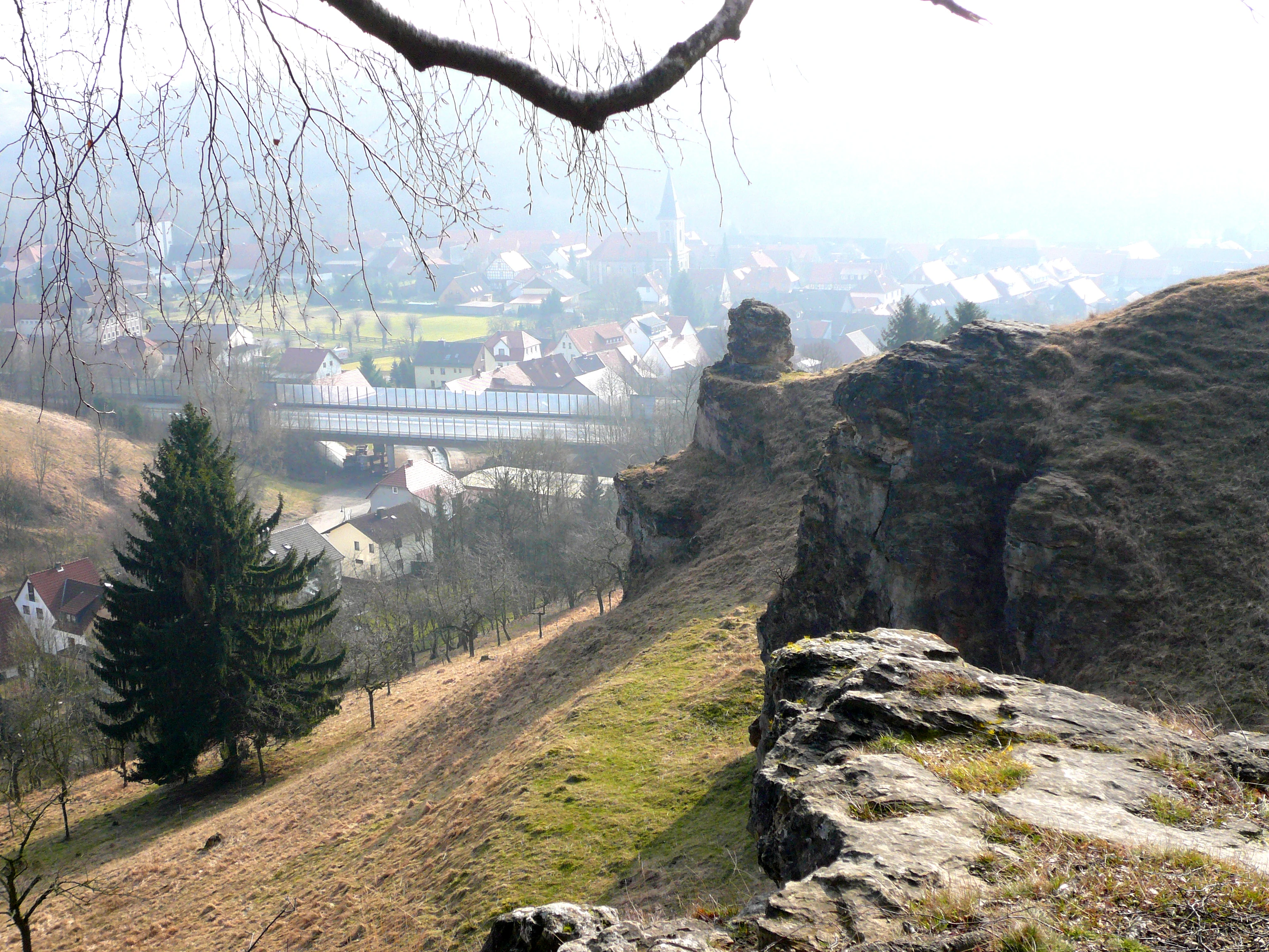
A high-angle view looking down a grassy, rocky hillside with a large evergreen tree on the left, overlooking a village in the misty valley below.
View of the eastern slope of the Steinberg mountain looking toward Scharzfeld.

Steinberg bei Scharzfeld history and protected-area timeline

The Steinberg bei Scharzfeld was formally placed under nature protection on 2 June 1988, establishing it as a Lower Saxon Naturschutzgebiet under the designation NSG BR 078. Its establishment reflected growing recognition of the unusual dolomite habitats present on the hill and the need to safeguard the calcareous grassland, rock vegetation, and associated wildlife that depend on traditional extensive land use.

Following its designation, the reserve was also recognized under the European Union's Habitats Directive, with the protected boundaries aligned with a same-named FFH area. The Landkreis Göttingen serves as the responsible lower nature protection authority, while broader technical and administrative oversight is provided by the NLWKN, the Lower Saxon state agency for water management, coastal protection, and nature conservation.

Steinberg bei Scharzfeld landscape and geographic character

The landscape of Steinberg bei Scharzfeld is defined by a steep southern ridge of dolomite rock rising above the surrounding low-mountain terrain of the southern Harz. The southerly slopes are sharp and rocky, with frequent exposed cliffs, ledges, and outcrops that give the reserve a distinctive rugged profile in contrast to the generally softer forested Harz slopes nearby.

The dolomite geology is central to the site's character. Unlike most of the surrounding Harz, where acidic substrates dominate, this hill is built from carbonate rock that weathers into thin, drought-prone soils. Open rock surfaces, broken block fields, and stony slopes create natural exposure and microclimatic conditions distinct from the wooded valleys around it, supporting vegetation that cannot survive on the more typical Harz substrates.

Steinberg bei Scharzfeld ecosystems, habitats, and plant life

The main ecological character of Steinberg bei Scharzfeld is shaped by its calcareous substrate. On the southern part of the ridge and its slopes, species-rich dry calcareous grassland (Kalkmagerrasen) has developed over centuries of extensive use and now harbors a notable diversity of grasses, herbs, and specialist plants typical of this rare habitat type in Lower Saxony. Without active management, these open grasslands would quickly be lost to shrub encroachment.

In the rocky outcrops and cliff faces, crevice vegetation colonizes the fissures in the dolomite, hosting plant communities adapted to thin soils, extremes of temperature, and limited water availability. In the northern part of the reserve, the slopes are wooded with mixed forest, which is being actively managed to gradually replace conifers and other less typical species with a composition closer to natural broadleaf and beech woodland. This creates a gradient from dry open grassland and rock habitats in the south to more shaded forest conditions in the north within a very compact area.

Steinberg bei Scharzfeld wildlife and species highlights

Wildlife information for this small reserve is closely tied to its calcareous grassland, rocky cliff habitats, and mixed forest mosaic. The combination of warm, dry open slopes and sheltered rocky areas supports invertebrates and pollinators associated with rare plant communities, while the wooded northern section provides habitat for forest-dwelling bird and mammal species typical of the southern Harz.

Because the site is small and largely defined by habitat structure rather than flagship species, its wildlife value lies more in the density and specialization of its plant and invertebrate communities than in any single charismatic mammal or bird. The presence of the Steinkirche cave also adds a subterranean habitat dimension, providing shelter for bat and other cave-associated fauna typical of karst and dolomite formations in the region.

Steinberg bei Scharzfeld conservation status and protection priorities

Steinberg bei Scharzfeld is a designated Naturschutzgebiet under Lower Saxon nature protection law, classified under the code NSG BR 078 and protected since 1988. Its primary conservation purpose is the long-term protection of calcareous grassland, dolomite rock vegetation, and the associated forest mosaic, all of which are uncommon habitat types in the broader Harz context.

The reserve coincides with a same-named European Habitats Directive (FFH) site, giving it recognized importance for habitat conservation at the EU level. It also borders the Harz landscape protection area, embedding it within a wider buffer of protected landscape in the southern Harz. Active conservation management is essential: goats are used to graze the dry grasslands and prevent shrub encroachment, while forestry in the northern section is directed toward converting existing mixed forest into a more natural broadleaf and beech composition.

Steinberg bei Scharzfeld cultural meaning and human context

The cultural dimension of Steinberg bei Scharzfeld is closely tied to traditional land use patterns that shaped its open grasslands. The species-rich calcareous meadows on the southern slopes are the product of long-standing extensive grazing, a practice that continues today in a modern form through the use of goats to maintain open habitat.

Within the reserve, the Steinkirche, a natural cave in the dolomite rock designated as a separate Naturdenkmal, adds a layer of geological and cultural significance. Caves and rock formations of this type have drawn local attention and curiosity for centuries and are an integral part of how the surrounding communities of Scharzfeld and Herzberg am Harz relate to their landscape.

Best time to visit Steinberg bei Scharzfeld

Spring and early summer are especially rewarding for visiting this type of reserve, when Calcareous grassland plants are in bloom and the contrast between open flowery slopes and the surrounding Harz forests is at its most visible. Late spring into early summer also brings warmer, drier conditions on the exposed dolomite slopes, making it easier to walk the trails and observe the rocky outcrops and the landscape toward Scharzfeld.

Late summer and early autumn can also be attractive, though vegetation on the dry slopes may appear more parched and less colorful. The mixed forest in the northern part of the reserve has a quieter, more shaded character year-round and can offer calmer walking conditions even when the open slopes are busy with visitors.

Monthly climate preview

Long-term representative monthly temperature ranges and precipitation averages for Steinberg bei Scharzfeld

Steinberg bei Scharzfeld Climate Normals, Annual Temperature and Precipitation Rhythm

Historical climatology data reveals the measured monthly temperature and precipitation rhythm across Steinberg bei Scharzfeld from representative coordinates. Examining the complete twelve-month profile provides deeper context for long-term meteorological patterns and seasonal trends.
Annual mean8 °C
-1 °C18 °C
Jan-1°
Feb-1°
Mar
Apr
May12°
Jun15°
Jul18°
Aug18°
Sep13°
Oct
Nov
Dec
Warmest month
July

17.7 °C

Coolest month
January

-1.4 °C

Wettest month
July

2.8 mm/day

Driest month
April

1.5 mm/day

Park location guide

Geography guide, regional context, and park location map for Steinberg bei Scharzfeld

Steinberg bei Scharzfeld park geography, regions, and map view in Germany

Understand where Steinberg bei Scharzfeld sits in Germany through a broader geographic reading of the surrounding landscape, nearby location context, and its mapped position within the national park landscape.

How Steinberg bei Scharzfeld fits into Germany

Germany is a federal republic in Western and Central Europe with a population of over 83 million across sixteen constituent states. It is Europe's largest economy by nominal GDP and a major global exporter and importer. The capital is Berlin, and the country borders Denmark, Poland, Czech Republic, Austria, Switzerland, France, Luxembourg, Belgium, and the Netherlands.

Wider geography shaping Steinberg bei Scharzfeld in Germany

Germany is located in Western and Central Europe, spanning 357,022 km². It borders Denmark to the north, Poland and the Czech Republic to the east, Austria and Switzerland to the south, and France, Luxembourg, Belgium, and the Netherlands to the west. The country has coastlines on the Baltic Sea and North Sea to the north, with the Alps located in the southern region.

Map view of Steinberg bei Scharzfeld

Use this park location map to pinpoint Steinberg bei Scharzfeld in Germany, understand its exact geographic position, and read its mapped placement within the surrounding landscape more clearly.

Pigeon | © OpenStreetMap contributors

Location context for Steinberg bei Scharzfeld

Lower Saxony
Recorded earthquake history

Explore Recorded Earthquake History Near Steinberg bei Scharzfeld

Examine the historical catalogue of seismic events recorded in the proximity of Steinberg bei Scharzfeld. MoriAtlas maintains this repository to provide clear access to epicentre data and magnitude records for the nature reserve and surrounding Harz landscape.

Steinberg bei Scharzfeld Earthquake History

Catalogued events

4 events

Strongest magnitude

Magnitude 3.6

Most recent event

Oct 25, 2006

This history includes earthquakes recorded inside the park or within 50 km of its borders

Explore protected area views, dolomite cliffs, and rare grassland habitats.

Steinberg bei Scharzfeld Photos and Landscape Scenery Visual Guide

Visual documentation of Steinberg bei Scharzfeld reveals steep dolomite rock outcrops, open calcareous grasslands, and unique low-mountain terrain across the southern Harz region. Examining these protected area photos helps researchers understand specialized cliff habitats and localized geological formations in greater detail.

A high-angle view looking down a grassy, rocky hillside with a large evergreen tree on the left, overlooking a village in the misty valley below.

Park atlas

Compare regional Harz mountain reserves and nearby protected areas in Lower Saxony

Explore Parks Near Steinberg bei Scharzfeld and Adjacent Protected Landscapes

Browsing other protected areas near Steinberg bei Scharzfeld reveals connected ecological zones across the southern Harz low-mountain terrain. Comparing adjacent reserves provides deeper context on regional dolomite geology, rare calcareous grasslands, and surrounding forest habitats.
Watercolor illustration of a mountainous landscape with forests and a winding path
National parkLower Saxony
3.8 km away#1 closest

Northeast

Harz National Park: A Mapped Protected Landscape in Lower Saxony's Mountains

Explore geographic boundaries and regional terrain.

Harz National Park is a protected area defined by its unique mountain landscape and extensive forests in Lower Saxony, Germany. This MoriAtlas entry details its geographic scope, allowing for exploration of its mapped boundaries and its place within the regional geography. Understand the terrain, from its highest peaks to its alpine bogs, offering a structured view of this significant protected landscape for atlas-based discovery.

Area
247 km²
Established
2006
IUCN
II
Visitors
4M annual
Nature reserveThuringia
About 12 km away#2 closest

Southeast

Sülzensee, Mackenröder Wald: A Detailed Look at Thuringia's Protected Nature Reserve

Exploring the beech forest landscapes and stream-carved terrain of northern Thuringia.

Sülzensee, Mackenröder Wald is a protected nature reserve in northern Thuringia known for its expansive beech forests and diverse geological foundation. Spanning over 280 hectares, the area features undulating ridges, deep-cut stream valleys, and a unique position atop the Elbe-Weser watershed. This geography-focused overview details the reserve's status as a corridor for wildlife and its significant role in regional habitat conservation.

Area
2.802 km²
Established
2000
IUCN
IV
A horizontal watercolor painting depicting a soft, rolling landscape with green meadows, patches of forest, and distant hills under a light sky.
Nature reserveLandkreis Eichsfeld
About 17 km away#3 closest

South

Grenzstreifen zwischen Teistungen und Ecklingerode Protected Nature Reserve Mapping

Conservation corridor within the Landkreis Eichsfeld regional geography.

Located in the Eichsfeld district of Thuringia, the Grenzstreifen zwischen Teistungen und Ecklingerode nature reserve functions as a vital segment of the trans-European Green Belt. This protected area showcases an elongated, structural diversity of beech forest ecosystems and meadowlands shaped by natural succession. Review the mapped boundaries and topographical characteristics of this significant corridor that bridges modern forestry and historical conservation.

Area
1.477 km²
Established
2000
IUCN
IV
Relief
Upland
A minimalist watercolor painting showing layers of rolling hills in soft green, purple, and pale yellow tones against a white background.
Nature reserveThuringia
About 19 km away#4 closest

South

Bodenstein Nature Reserve: Geographic Atlas and Protected Area Context in Thuringia

Limestone escarpments and ravine landscapes of the Eichsfeld

Bodenstein is a protected nature reserve featuring a distinctive limestone escarpment along the Ohmgebirgsplateau. The terrain encompasses a series of hilltops and ravines shaped by geological shifts, serving as a key reference site for the forest ecosystems and spring-fed hydrological networks found across the Thuringia region.

Area
1.335 km²
Established
1961
IUCN
IV
Relief
Upland
Nature reserveLower Saxony
19 km away#5 closest

Northeast

Wurmberg Nature Reserve: Protected Granite Peaks and High Mountain Bog Landscapes

High-altitude Harz mountain geography in Lower Saxony

Wurmberg Nature Reserve represents a critical protected zone in the Harz mountains, featuring the Große Klippe granite cliffs and legacy quarry landscapes. The area provides essential data for understanding forest conversion and peatland rewetting, forming an integral part of the regional conservation network in Lower Saxony, Germany.

Area
1.83 km²
Established
2006
IUCN
IV
Relief
Mountain
A soft watercolor illustration depicting layered green and pale pink rolling hills under a light sky.
Protected areaThuringia
23 km away#6 closest

South

Bleicheröder Berge: Geographic Profile and Protected Landscape Context in Thuringia

Mapping the forested ridges and Muschelkalk geology of the Thuringian region.

Investigate the Bleicheröder Berge as a vital protected area in Thuringia. This resource outlines the range's formation as a series of isolated hill remnants, its fossil-bearing limestone cliffs, and the botanical diversity characterizing its beech forests and rare orchid populations.

Area
16 km²
Relief
Mountain
Climate
Temperate
Access
Easy access
Protected landscapeLower Saxony
About 23 km away#7 closest

North

Naturpark Harz (Niedersachsen): Mapped Protected Landscapes and Regional Terrain

Regional geography and protected area boundaries in Lower Saxony

Spanning roughly 790 square kilometers, Naturpark Harz (Niedersachsen) serves as a vital protected area along the western Harz mountains. The park landscape showcases a transition from high-elevation summits like the Wurmberg down to lowland foothills, integrated with a historic system of reservoirs and river valleys that define the regional geography.

Area
790 km²
Established
1960
Water
Major water bodies
Nature reserveThuringia
About 24 km away#8 closest

East

Vogelherd Nature Reserve: Montane Beech Forest Landscape in Thuringia, Germany

Protected forest geography in the northern Harz mountains.

Vogelherd is a significant nature reserve located in the Harz mountains of Thuringia. It serves as a vital reference area for upper montane forest ecology, showcasing how acidic bedrock and high elevation shape the transition between beech and spruce woodland populations.

Area
0.151 km²
Established
1961
IUCN
IV

Common questions about visiting, size, designation, and location context for Steinberg bei Scharzfeld

Steinberg bei Scharzfeld FAQs for park facts, access, geography, and protected area context

Find quick answers about Steinberg bei Scharzfeld, including protected-area facts, park geography, trail and visitor context, and how the park fits into its surrounding country and regional landscape.
MoriAtlas Explorer

Continue Your Protected Areas Search Across the Global Atlas

Deepen your exploration by continuing the structured search for national parks and protected areas worldwide. Utilize the comprehensive filtering capabilities to compare different conservation landscapes and refine your understanding of global park geography. Discover more about the distribution and characteristics of protected natural areas.

Global natural geography