
Mori Atlas logo
Natural monumentVernéřovské doly

Examining the unique quartz-amblygonite pegmatite veins and historic mining landscape in western Czech Republic.

Vernéřovské doly Natural Monument and Geological Heritage Site in the Karlovarský kraj Region

Vernéřovské doly represents a significant geological monument in the Karlovarský kraj, protecting a rare vein system that showcases complex lithium and tin mineralization. This small site preserves the physical remnants of historic mine workings, offering a precise cross-section of paragneiss and pegmatite strata. Its protected boundaries secure a rare geological feature within the broader landscape of the western Czech Republic.

natural monumentgeological heritagepegmatite mineralizationlithium mineralsamblygonitetin ore
A flat-style digital illustration depicting a vast mountain valley with a tall waterfall cascading down a cliff, a winding river in the foreground, and coniferous forests under a bright sun.

Vernéřovské doly

Natural monument

Park overview

Structured park overview, official facts, and landscape profile for Vernéřovské doly

Vernéřovské doly park facts, protected area profile, and essential visitor context

Review the core facts for Vernéřovské doly, including designation, size, terrain, visitor scale, habitats, and operating context in one park-focused overview.

About Vernéřovské doly

Vernéřovské doly is a small but geologically specialized protected area in the westernmost part of the Czech Republic, in the Cheb District along the border region of the Karlovarský Region. The site lies in the vicinity of Vernéřov, a village that is administratively part of the town of Aš, and preserves the surface remnants of an old mining operation in the form of exposed spoil heaps. Its significance does not derive from size, scenic beauty, or biodiversity, but from the unusual geological exposure it provides.

The geology of the locality is dominated by a vein complex made up of quartz, amblygonite (a lithium-bearing phosphate mineral), and microcline feldspar, embedded in metamorphic rocks known as paragneiss. Czech geologists interpret the deposit as a pegmatite of special character, one that was later affected by hydrothermal activity which introduced additional elements such as tin, copper, iron, zinc, and molybdenum. As a result, the ore assemblage includes both lithium-bearing minerals and metallic ore minerals such as cassiterite, producing what is described as an entirely distinctive paragenetic type within the country.

The main lode has a thickness of roughly 50 to 70 centimeters and an estimated total length of about one kilometer. Between 1954 and 1958 the site underwent geological exploration aimed at verifying ore reserves, but the work was halted because the extent of mineralization proved too small to justify further development. Despite this economic disappointment, the scientific value of the exposure remained, and the area was eventually declared a natural monument in 1999 to ensure that the outcrop and its mineralogical context would remain preserved. Mineralogically similar deposits of comparable type have been documented only in Portugal and in the Ural Mountains of Russia, placing Vernéřovské doly in a small group of internationally significant rare-element pegmatite localities.

Quick facts and research context for Vernéřovské doly

Location: near Vernéřov, part of the town of Aš, Cheb District, Karlovarský Region, Czech Republic. Protected designation: přírodní památka (natural monument), IUCN Category III. Area: approximately 0.26 hectares. Elevation: roughly 620 to 638 meters. Date of designation: 20 April 1999. Administering authority: Regional Authority of the Karlovarský Region. Reason for protection: preservation of mine spoil heaps exposing a rare quartz-amblygonite-microcline vein with tin and other ore mineralization.

Protection and recognition

Documented terrestrial protection scope, establishment year, and management context.

Vernéřovské doly Protection Status and Official Designation History

Vernéřovské doly maintains a documented terrestrial protection status established in 1999. Structured records organize historical designation dates and management scope for environmental analysis.

Protection details

Protection scope
Terrestrial
Designated year
1999
Park context

Deeper park guide and search-rich context for Vernéřovské doly

Vernéřovské doly history, landscape, wildlife, and travel context

Explore Vernéřovské doly through its history, landscape character, ecosystems, wildlife, conservation priorities, cultural context, and seasonal travel timing in a structured park guide built for atlas discovery and search intent.

Why Vernéřovské doly stands out

Vernéřovské doly is best known for its exceptional lithological and mineralogical character, specifically a quartz-amblygonite-microcline vein system hosted in paragneiss. The site is regarded as a rare example of a pegmatite enriched by later hydrothermal input of tin, copper, iron, zinc, and molybdenum, producing a unique paragenetic type in the Czech Republic. Comparable lithium and tin mineralizations of this type are documented only in Portugal and in the Ural Mountains of Russia, which gives the locality a position of more than purely regional geological interest.
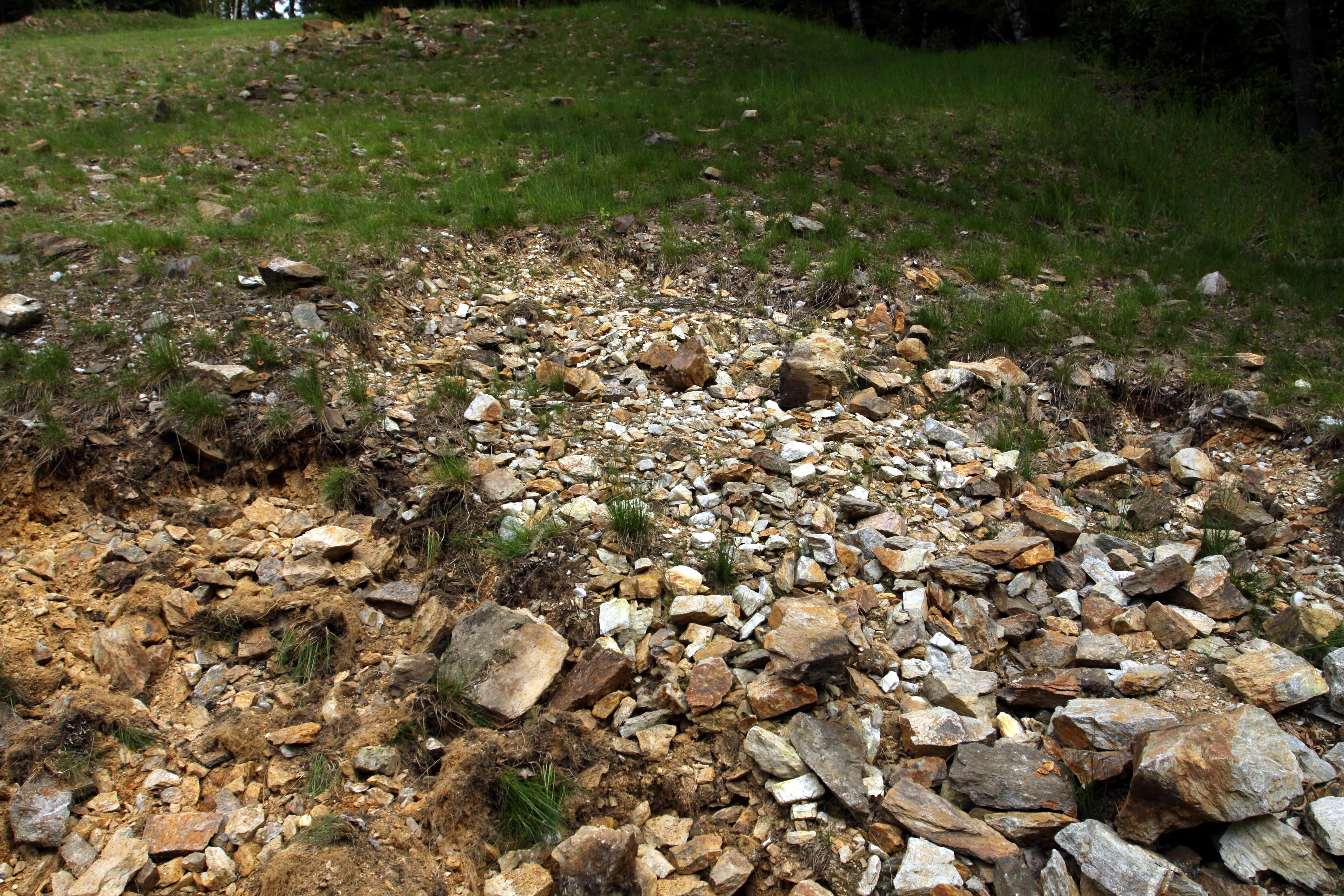
A sloped, rocky ground area covered in scattered pale and brownish stones, showing the historical mining site, with patches of green grass growing among the rocks.
A view of the mineral-rich mining dumps at the Vernéřovské doly natural monument.

Vernéřovské doly history and protected-area timeline

The mining heritage of Vernéřovské doly reflects a long tradition of small-scale prospecting in the Aš area of western Bohemia, where various mineral resources were investigated over time. The specific deposit at Vernéřovské doly was historically worked for its amblygonite pegmatite and associated ore minerals, including cassiterite, leaving behind the spoil heaps and surface workings that define the present-day protected site.

Renewed scientific and economic attention came between 1954 and 1958, when geological exploration was carried out to assess reserves of lithium and tin ores. Although the vein system was scientifically interesting, the overall scale of mineralization was judged too limited, and the exploration work was discontinued. This outcome preserved the locality from large-scale industrial extraction and kept the geological exposure intact for later scientific study.

Recognition of the site's broader significance came on 20 April 1999, when the area was officially declared a přírodní památka, or natural monument, under Czech protected-area law. Since then, the property has been managed by the Regional Authority of the Karlovarský Region, with the explicit purpose of safeguarding the geological exposure and the unusual mineral assemblage it contains.

Vernéřovské doly landscape and geographic character

The landscape around Vernéřovské doly belongs to the gently undulating terrain of the Cheb District in the western Karlovarský Region, close to the Czech border with Germany. Elevations in and around the protected site sit between roughly 620 and 638 meters above sea level, placing the locality on a relatively modest hill or ridge rather than within a dramatic mountain environment. The broader surroundings reflect the mixed forest and agricultural land characteristic of the Aš area, where the protected site occupies only a tiny footprint of about 0.26 hectares.

At the site itself, the visible landscape is dominated by mine spoil heaps (odvaly) that mark the location of the old workings. These spoil heaps expose the vein material and host rocks, and they form the actual surface feature that the natural monument designation is intended to protect. The setting is not one of sweeping vistas but rather of a localized geological exposure embedded in an otherwise unremarkable stretch of Czech countryside, which makes its protected status almost entirely dependent on what lies beneath the surface rather than on the scenery above it.

Vernéřovské doly ecosystems, habitats, and plant life

Ecologically, Vernéřovské doly is not a site of broad biodiversity significance. The protected area is extremely small, covering just 0.26 hectares, and its designation is firmly rooted in geology rather than in habitats, flora, or fauna. The vegetation over the spoil heaps and surrounding ground is typical of disturbed, mineral-rich ground in the western Bohemian countryside, with the immediate ecological focus being the protection of the exposed rock and mineral material itself rather than any wider biological community.

The broader ecological character of the region around Vernéřovské doly reflects the moderately elevated, mixed-forest landscape of the Aš area, where deciduous and coniferous stands alternate with farmland and small villages. Within the protected boundary itself, however, the natural monument functions more as a guardian of a geological exposure than as a habitat reserve, and ecological processes play only a secondary role in its protection rationale.

Vernéřovské doly conservation status and protection priorities

The conservation importance of Vernéřovské doly lies almost entirely in the protection of a rare geological and mineralogical exposure rather than in habitat or species conservation. By declaring the area a přírodní památka in 1999, Czech authorities placed the mine spoil heaps and underlying vein system under formal protection, ensuring that the outcrop cannot be destroyed, buried, or removed through land-use change. The site's IUCN Category III designation reflects its character as a natural monument focused on a specific geological feature of national significance.

Beyond its Czech context, the deposit carries international relevance. Its combination of amblygonite-bearing pegmatite with cassiterite and other hydrothermal ore minerals is described as a paragenetic type otherwise documented only in Portugal and in the Ural Mountains of Russia. In preserving this exposure, the protected area safeguards an unusually complete example of a rare-element pegmatite locality for future geological research and reference, which is the central justification for its continued protection under the administration of the Regional Authority of the Karlovarský Region.

Vernéřovské doly cultural meaning and human context

The cultural context of Vernéřovské doly is closely tied to the mining and geological prospecting tradition of the western Bohemian borderland. The village of Vernéřov, part of the town of Aš, lies in a region with a long history of small-scale extraction of various minerals, and the old workings at the site represent a particular chapter in that local heritage. The locality is appreciated more by geologists and mineral collectors than as a site of broader cultural or historical narrative, and its protected status reflects the Czech tradition of recognizing scientifically valuable mineral localities as part of national natural heritage.

Top sights and standout views in Vernéřovské doly

Among the defining qualities of Vernéřovské doly is its exceptionally rare quartz-amblygonite-microcline vein system, which most Czech geologists classify as a pegmatite with distinctive hydrothermal overprints. The main vein reaches a thickness of 50 to 70 centimeters and an estimated total length of about one kilometer, while the surrounding spoil heaps preserve an accessible and scientifically valuable cross-section of the deposit. The site's international standing is reinforced by the fact that comparable lithium-tin mineralization is documented only in Portugal and in the Russian Urals.

Best time to visit Vernéřovské doly

Because Vernéřovské doly is a small geological monument rather than a landscape attraction, seasonality has limited impact on its basic accessibility. The spring and early summer months tend to make the surrounding vegetation most visible and can help contrast the spoil heaps against fresh green growth, while visits in late autumn or winter expose the rocks more clearly by reducing ground cover. Since the site is a protected geological exposure rather than a developed visitor attraction, visitors should treat it primarily as a reference outcrop within the broader rural landscape of the Aš area.

Monthly climate preview

Monthly temperature ranges and precipitation averages recorded at reference coordinates

Vernéřovské doly Climate Normals and Long-Term Temperature Patterns

Long-term NASA data records average monthly temperatures spanning from sub-zero winter minimums to warm summer maximums alongside consistent daily precipitation. Reviewing the complete twelve-month climatology profile provides detailed insight into annual weather patterns across the representative elevation.
Annual mean7 °C
-3 °C18 °C
Jan-3°
Feb-2°
Mar
Apr
May12°
Jun16°
Jul18°
Aug18°
Sep13°
Oct
Nov
Dec-2°
Warmest month
July

17.8 °C

Coolest month
January

-3.1 °C

Wettest month
July

2.7 mm/day

Driest month
April

1.4 mm/day

Park location guide

Geography guide, regional context, and park location map for Vernéřovské doly

Vernéřovské doly park geography, regions, and map view in Czechia

Understand where Vernéřovské doly sits in Czechia through a broader geographic reading of the surrounding landscape, nearby location context, and its mapped position within the national park landscape.

How Vernéřovské doly fits into Czechia

Czech Republic is a landlocked Central European country with a population of approximately 10.9 million people. The nation was established as an independent state on January 1, 1993, following the dissolution of Czechoslovakia. Its capital and largest city is Prague, with other major urban centers including Brno, Ostrava, Plzeň, and Liberec.

Wider geography shaping Vernéřovské doly in Czechia

The Czech Republic is a landlocked country in Central Europe. It is bordered by Germany to the west, Austria to the south, Poland to the northeast, and Slovakia to the southeast. The landscape is predominantly hilly, with the territory covering 78,871 square kilometers.

Map view of Vernéřovské doly

Use this park location map to pinpoint Vernéřovské doly in Czechia, understand its exact geographic position, and read its mapped placement within the surrounding landscape more clearly.

Pigeon | © OpenStreetMap contributors

Location context for Vernéřovské doly

Karlovarský kraj

Visual reference guide to the protected terrain, geological features, and surrounding environment

Vernéřovské doly Photos and Landscape Scenery

Visual documentation of Vernéřovské doly captures the distinctive surface spoil heaps and rolling regional terrain of this protected Czech geological site. Examining these landscape views helps researchers and visitors understand the physical context of the rare mineral vein system.

A sloped, rocky ground area covered in scattered pale and brownish stones, showing the historical mining site, with patches of green grass growing among the rocks.

Park atlas

Discover related regional landscapes and connected geological heritage sites across the Cheb District.

Other Parks Near Vernéřovské Doly and Surrounding Protected Areas to Compare

Continue exploring protected areas near Vernéřovské doly to compare nearby geological reserves and regional natural monuments. Regional park browsing expands geographic context across the western Karlovarský landscape.
Nature reserveKarlovarský kraj
About 15 km away#1 closest

South

Pomezní rybník Nature Reserve: Geographic Overview and Protected Wetland Boundaries

Borderland wetland ecology in the Karlovarský kraj region

Pomezní rybník represents a small but significant nature reserve known for its unique location where the state boundary bisects the central pond. The reserve provides a concentrated habitat for wetland species, featuring a rare botanical assemblage and transitional terrain between the lowland basin and highland slopes of the western Czech Republic.

Area
0.017 km²
Established
1990
Relief
Lowland
Scope
Terrestrial
Watercolor painting of columnar basalt formations surrounded by a pine forest and soft, layered hills in the background.
Natural monumentKarlovarský kraj
About 25 km away#2 closest

East

Rotava Natural Monument: Geological Landforms and Basalt Outcrops in the Karlovarský kraj Region

Protected volcanic terrain and rare botanical habitats in the Czech Republic

Rotava Natural Monument showcases remarkable vertical basalt columns formed by ancient volcanic activity. Located in the Karlovarský kraj region, this site provides a dense, concentrated look at columnar jointing and the specific meadow flora that thrives in its mineral-rich, acidic soil conditions, serving as a landmark for regional geological study.

Area
0.003 km²
Established
1978
IUCN
IV
Relief
Mountain
A horizontal watercolor painting showing rolling green hills and distant mountain ridgelines behind a foreground of grassy meadows and trees.
Nature reserveSaxony
About 32 km away#3 closest

Northeast

Dreibächel Nature Reserve: Mapping the Old-Growth Spruce Stands of the Western Ore Mountains

A historic protected landscape and mountain watershed in Saxony, Germany

Dreibächel serves as a living archive of traditional forest management, holding the distinction of containing the oldest spruce trees in Saxony. Located on the slopes of the Schneehübel, the reserve is characterized by a dense, multi-layered mountain forest canopy and the confluence of three vital streams. The area remains a essential site for observing historical plenterwald ecology and the natural hydrology of the Westerzgebirge region.

Area
0.147 km²
Established
1961
IUCN
IV
A soft watercolor painting showing a pond landscape with rolling hills in the background, green trees in the midground, and tall grasses along the water edge.
Nature reserveSachsen
About 32 km away#4 closest

Northwest

Großer Weidenteich Nature Reserve: Mapping the Biodiversity of the Saxon Vogtland

A vital protected landscape shaped by traditional grazing management

Großer Weidenteich acts as a crucial refuge for diverse species, including nearly 700 butterfly varieties and numerous breeding bird populations. The reserve's landscape is characterized by a mix of wetlands, meadows, and shrubby margins that rely on continuous sheep grazing for structural maintenance. This area provides a clear perspective on how small-scale water bodies and varied vegetation patches contribute to the health of the broader Saxon regional ecosystem.

Area
3.349 km²
Established
1994
IUCN
IV
Watercolor painting of a flat marshy landscape with a small winding stream in the foreground, green trees in the midground, and soft purple mountain silhouettes in the distance.
Nature reserveSaxony
About 33 km away#5 closest

Northeast

Großer Kranichsee Nature Reserve: Protected Raised Bog Geography and Ore Mountain Landscapes

Watershed moorland, mountain pine forests, and Saxony high plateau geography.

Großer Kranichsee serves as a primary example of an intact raised bog system in the Ore Mountains. The reserve features rare peat-forming vegetation and highland bog forests, occupying a high-altitude plateau that bridges the border between Saxony and the Czech Republic. Its geographic significance stems from its role as a triple watershed, defining the drainage patterns for three distinct regional river systems within the protected Erzgebirgskamm zone.

Area
6.11 km²
Established
1912
A horizontal watercolor illustration depicting a soft, green, mountain landscape with hills, conifers, and a waterlogged meadow.
Natural monumentKarlovy Vary Region
About 35 km away#6 closest

Northeast

Rudenská luční prameniště Natural Monument: Protected Mountain Wetland Atlas

Karlovy Vary Region Ore Mountains landscape mapping

Rudenská luční prameniště is a protected mountain wetland in the Ore Mountains, defined by a distinct mosaic of spring fens, peat deposits, and mountain meadows. Its geographic layout, spanning twenty three hectares across sloping terrain, creates a vital drainage system for the local landscape. By examining this protected site, you can better understand the unique hydrological and botanical features that distinguish these rare mountain mire complexes from the surrounding highland forests.

Area
0.232 km²
Established
2020
IUCN
IV
Relief
Mountain
A horizontal watercolor illustration of a gentle landscape with scattered trees, soft green foliage, and faint mountain outlines in the background.
Nature reserveSaxony
About 35 km away#7 closest

Northeast

Am Riedert Nature Reserve: Protected Mountain Forest Geography in Saxony, Germany

Analyzing the ecological boundaries and Hercynian mountain mixed forest terrain

Am Riedert is a compact but ecologically important nature reserve situated on the rugged slopes of the western Erzgebirge. This site protects a significant example of mountain mixed forest, characterized by its mature silver fir populations and active natural regeneration. By examining its location south of the Zwickauer Mulde river, visitors can trace the intersection of Saxon history and conservation within this unique protected landscape.

Area
0.185 km²
Established
1961
IUCN
IV
Relief
Mountain
Protected landscapeBavaria
About 36 km away#8 closest

West

Naturpark Frankenwald: Geographic Profile of Bavaria's Forested Protected Landscape

A vast, interconnected upland spanning the Bavaria and Thuringia border

Naturpark Frankenwald functions as a large-scale managed nature preserve that integrates cultural heritage with ecological conservation. The terrain consists of gentle mountainous ridges, narrow river valleys, and extensive mixed forests that form a continuous landscape belt across northern Bavaria. This profile provides an overview of the regional geography, boundary extent, and the natural features that define this significant central German upland area.

Area
1,023 km²
Established
1973
Relief
Upland
Climate
Temperate

Common questions about visiting, size, designation, and location context for Vernéřovské doly

Vernéřovské doly FAQs for park facts, access, geography, and protected area context

Find quick answers about Vernéřovské doly, including protected-area facts, park geography, trail and visitor context, and how the park fits into its surrounding country and regional landscape.
MoriAtlas Explorer

Continue Your Protected Areas Search Across the Global Atlas

Deepen your exploration by continuing the structured search for national parks and protected areas worldwide. Utilize the comprehensive filtering capabilities to compare different conservation landscapes and refine your understanding of global park geography. Discover more about the distribution and characteristics of protected natural areas.

Global natural geography