
Mori Atlas logo
Natural monumentVeselský chlum

Analyzing the ecological mosaic and hilltop terrain within the South Moravian region

Veselský chlum Natural Monument: Mapped Geography and Protected Highland Landscape Context

(Přírodní památka Veselský chlum)

Veselský chlum stands as a notable natural monument within the Bohemian-Moravian Highlands, characterized by a compact mosaic of dry grassland, scrub, and woodland patches. This protected area captures an ecologically valuable summit where traditional land management maintains a diverse habitat pattern across a modest elevation. The site map reveals a distinct transition between open hilltop terrain and the rocky slope environments found in the adjacent conservation network.

natural monumentprotected landscapeBohemian-Moravian HighlandsHornosvratecká vrchovinadry grasslandhabitat mosaic
A flat-style digital illustration of a valley landscape featuring soft pastel colors, green meadows, blooming trees, a winding river, and distant hills under a warm sky.

Veselský chlum

Natural monument

Park overview

Structured park overview, official facts, and landscape profile for Veselský chlum

Veselský chlum park facts, protected area profile, and essential visitor context

Review the core facts for Veselský chlum, including designation, size, terrain, visitor scale, habitats, and operating context in one park-focused overview.

About Veselský chlum

Veselský chlum is located in the Hornosvratecká vrchovina, the highland spine that forms part of the broader Bohemian-Moravian Highlands in the Czech Republic. The hill lies west of the market town of Lomnice, in the Brno-venkov district of the South Moravian Region. Although it is not particularly tall by national standards, the hill carries an identity and an ecological importance that are out of proportion to its physical scale, primarily because of the way different habitats interact across its summit and slopes.

The landscape around Veselský chlum is shaped by the rolling character typical of the Bohemian-Moravian Highlands, with a mixture of forests, fields, meadows, pastures, and scattered small settlements. Within this broader matrix, the hill itself is unusual in that a sizable proportion of its upper surface remains open. The natural monument status is built around protecting the resulting mosaic of dry and semi-dry grassland, shrubby transitions, and forest patches that occupy different parts of the hill, each in relatively close proximity to the others.

The protected area covers the summit and an adjoining portion of the slopes, ensuring that the most ecologically important sections of the hill remain managed as open habitat rather than being lost to forest succession. On the northwestern side, the hill transitions into the Sokolí skála nature reserve, which protects a different but complementary set of habitats, including rock and cliff communities. Together, the two sites form a small but coherent complex of protected open and semi-open habitats within an otherwise forested highland.

Visually, Veselský chlum offers a long sight line across the Highlands, and because the hilltop is open, the broad curve of the surrounding landscape is visible in nearly all directions. This openness is both an aesthetic asset and part of the reason the vegetation mosaic is maintained: traditional land use such as grazing, mowing, and selective clearing has prevented the open habitats from being swallowed by forest, which in turn preserves the conditions that the protection status is designed to safeguard.

Quick facts and research context for Veselský chlum

Veselský chlum is an IUCN Category IV protected natural monument in the South Moravian Region of the Czech Republic, in the Brno-venkov district near Lomnice. It sits within the Hornosvratecká vrchovina, a highland area of the Bohemian-Moravian Highlands, and its summit reaches 578 meters above sea level. The protected area covers the summit and a portion of the hill's slopes, and the adjacent Sokolí skála nature reserve adjoins its northwestern flank. The monument was designated in 1991 by the Regional Authority of the South Moravian Region in recognition of the hill's unusual vegetation mosaic and the traditional management practices that sustain it.

Protection and recognition

Documented protection scope and international recognition framework

Veselský Chlum Protection Status and Terrestrial Conservation Records

Veselský chlum maintains a classified terrestrial protection scope within the regional conservation network. Documented status details highlight the official administrative framework governing the protected landscape.

Protection details

Protection scope
Terrestrial
Transboundary protection
No
Park context

Deeper park guide and search-rich context for Veselský chlum

Veselský chlum history, landscape, wildlife, and travel context

Explore Veselský chlum through its history, landscape character, ecosystems, wildlife, conservation priorities, cultural context, and seasonal travel timing in a structured park guide built for atlas discovery and search intent.

Why Veselský chlum stands out

Veselský chlum is best known for its unusually compact mosaic of different vegetation formations on a single low summit, including open grassland, scattered shrubs, and patches of woodland that succeed one another across very short distances. This habitat diversity is maintained by traditional grazing and land management rather than by any particularly dramatic geological or topographic setting. The hilltop is also appreciated for the wide, uninterrupted views it offers over the surrounding Bohemian-Moravian Highlands, thanks to its largely unforested summit.
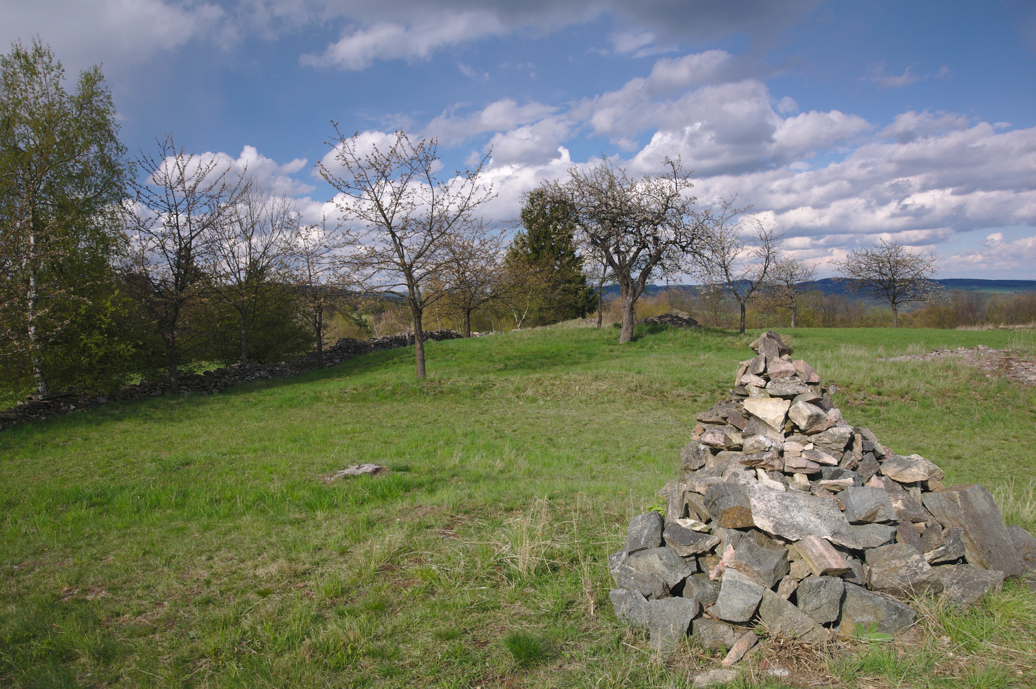
A green hillside with a stone cairn in the foreground, scattered deciduous trees, and a distant treeline under a partly cloudy blue sky.
A view of the open meadows and scattered trees at the Veselský chlum natural monument.

Veselský chlum history and protected-area timeline

Veselský chlum was formally designated as a protected natural monument on 1 January 1991 by the Regional Authority of the South Moravian Region. The designation was driven by the recognition that the hill's unusual mosaic of grassland, shrub, and woodland habitats, together with the traditional land management practices that produced and sustain them, was worth protecting against the broader trend of agricultural abandonment and forest expansion that has affected many similar sites in the Czech countryside.

The protected area covers the summit and portions of the surrounding slopes, while the adjacent Sokolí skála nature reserve was already in place on the northwestern flanks, helping to extend the conservation network across the hill. The relatively late formal designation reflects a longer history in which the hill's mosaic of vegetation was maintained primarily through traditional local use rather than deliberate conservation policy.

Veselský chlum landscape and geographic character

Veselský chlum is a low, rounded hill within the Hornosvratecká vrchovina, a highland region that forms the southern portion of the broader Bohemian-Moravian Highlands. The summit elevation is 578 meters, and the bottom of the protected envelope begins around 520 meters, indicating a modest relief of only around 60 meters within the site itself.

The defining landscape feature of the hill is not its elevation but rather its open, partly unforested summit and upper slopes. Where many other summits in the Highlands are blanketed uniformly by coniferous or mixed forest, Veselský chlum retains broad sections of grassland, scrubby transitions, and woody patches that meet along short distances. The northwestern flank of the hill passes into the rock and slope habitats of the adjacent Sokolí skála nature reserve, providing a structural contrast between the open hilltop and the more rugged slope habitats nearby.
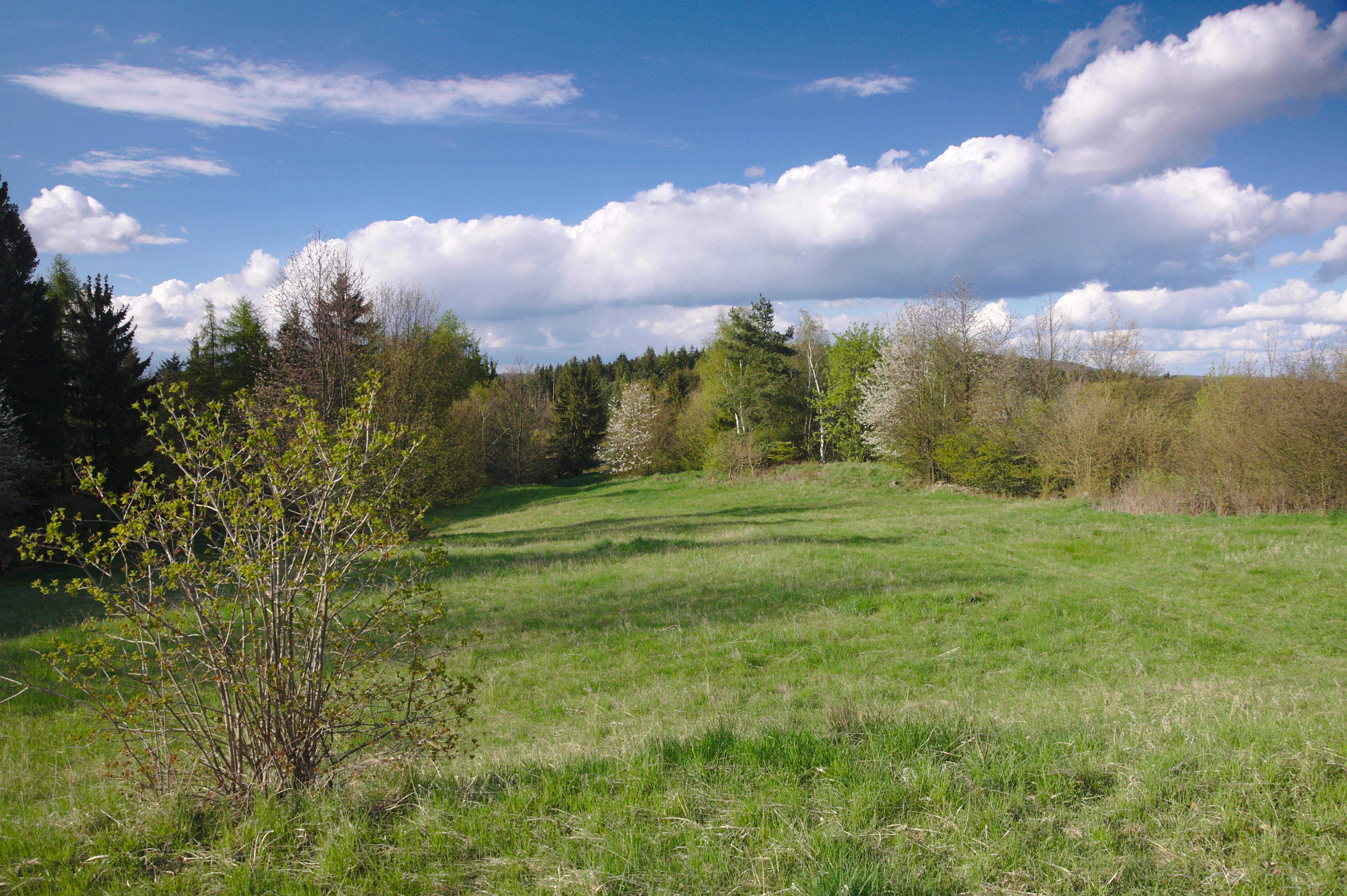
A wide view of a sloping green meadow bordered by diverse mixed forest and flowering shrubs under a blue sky with scattered white clouds.
A grassy meadow at the Veselský chlum natural monument, showcasing the region's diverse vegetation mosaic.

Veselský chlum ecosystems, habitats, and plant life

Ecologically, Veselský chlum is notable for the compressed mosaic of different vegetation formations found on a single hill. Within the protected area, dry and semi-dry grassland communities, low shrubby transitions, and patches of woodland occur in close juxtaposition rather than as separate large blocks of habitat. This pattern is characteristic of longstanding cultural landscapes in the region, where grazing, mowing, and selective woodland use have prevented any one habitat type from dominating.

The result is a habitat composition of high local value despite the small overall area. Open, sun-exposed dry grassland provides conditions for warmth-loving plant communities, while the shrub and woodland patches offer structural variety and shelter for associated fauna. Because the habitats are tightly interwoven, the site supports a richer set of ecological interactions than its size alone would suggest.
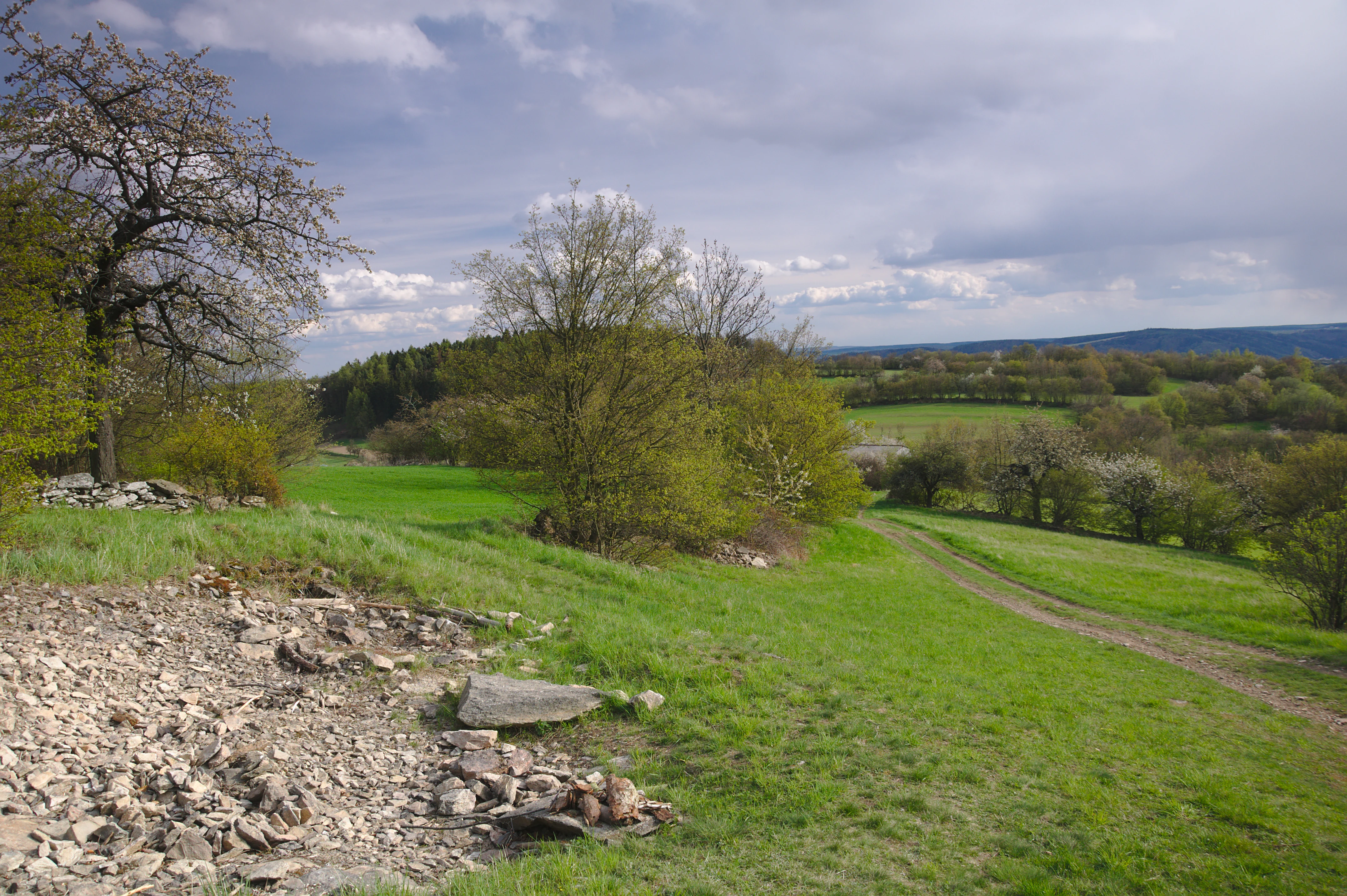
A wide, eye-level shot of a grassy, rolling landscape in the Czech Republic, featuring rocky patches in the foreground, scattered deciduous trees, and a dirt path leading into the rolling hills under a cloudy sky.
A scenic view of the rolling green slopes and traditional landscape at Veselský chlum.

Veselský chlum wildlife and species highlights

The wildlife profile of Veselský chlum is shaped primarily by the close coexistence of open dry grassland, shrubby edges, and woodland patches across a small terrain. This structural variety typically supports a mix of species associated with warm, dry open habitats as well as those tied to scrub and woodland edge environments, including invertebrates and birds that depend on open grass and shrub mosaics for nesting and foraging.
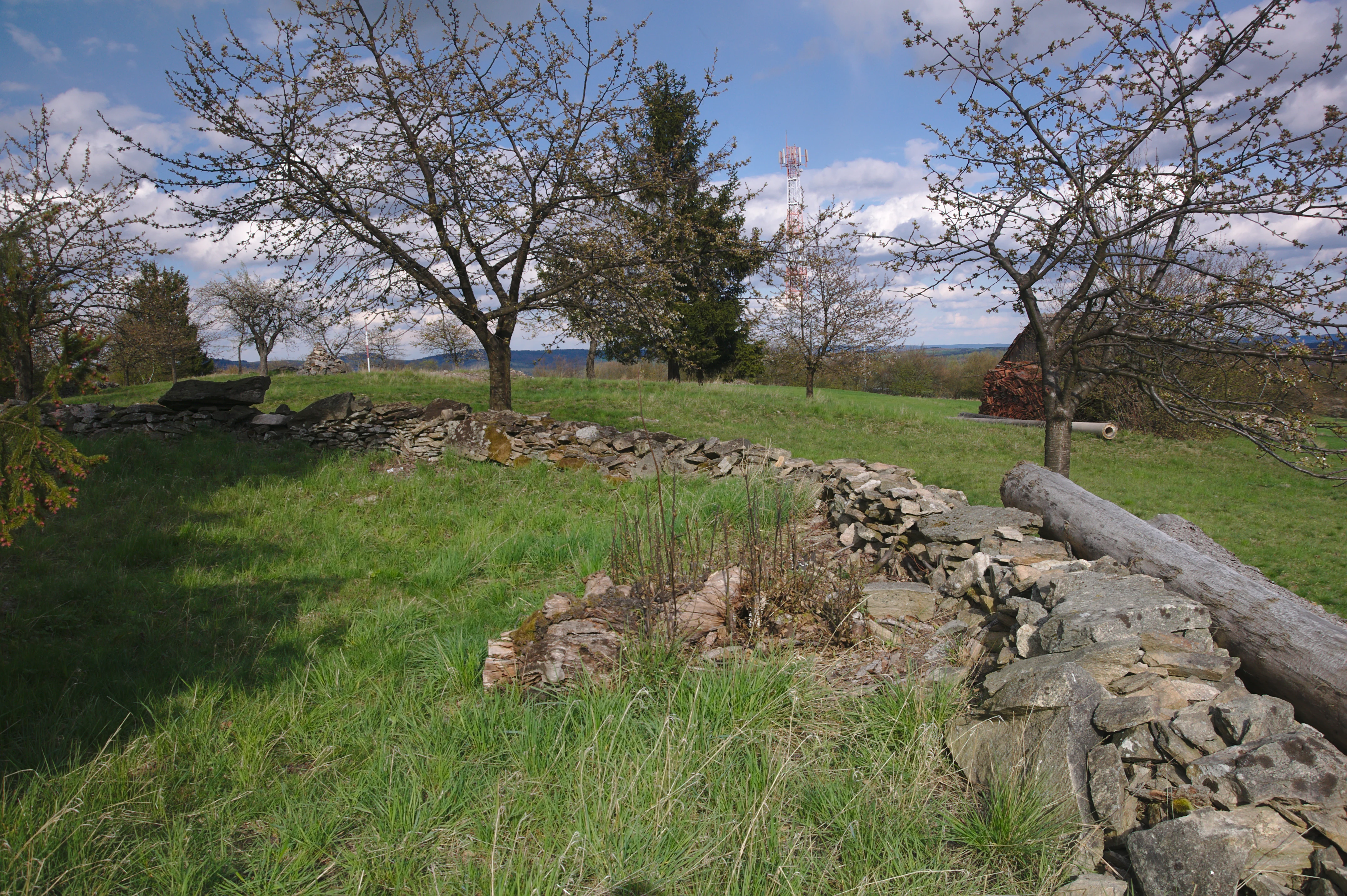
A green hillside meadow in the Czech Republic featuring a dry stone wall, sparse deciduous trees, and an overcast sky.
A grassy meadow bordered by a traditional dry stone wall at Veselský chlum.

Veselský chlum conservation status and protection priorities

Veselský chlum is recognized under IUCN Category IV, a designation applied to habitat or species management areas where protection focuses on maintaining a particular set of habitat conditions rather than on wilderness preservation or ecological process protection. The reason for protection, as documented at the time of designation, is the preservation of the hill's unusual mosaic of vegetation formations and the traditional land management practices that continue to keep those habitats open and varied.

The conservation significance of the site lies less in any single species or geological feature and more in the maintenance of a small but representative example of a highland cultural landscape that is otherwise disappearing across much of Central Europe. Its adjacency to the Sokolí skála nature reserve increases the overall ecological coherence of the protected area around the hill.

Veselský chlum cultural meaning and human context

Veselský chlum reflects a long history of cultural shaping of the Czech highland landscape, in which traditional grazing, mowing, and small-scale forest use have produced open, varied habitats on hilltops and slopes. The continued presence of this mosaic is itself a record of how local communities have interacted with the highland environment over generations, and protecting the site is as much about preserving that land-use legacy as it is about safeguarding any single species or community.

Top sights and standout views in Veselský chlum

The standout qualities of Veselský chlum are the unusually tight mosaic of dry grassland, scrub, and woodland on a single low summit within the Bohemian-Moravian Highlands, the broad open views from an unforested hilltop, and the complementary protected habitats of the adjacent Sokolí skála nature reserve on its northwestern slopes. Small in size but distinctive in character, the site exemplifies how traditional highland land use can sustain a high-value ecological mosaic within a compact area.

Best time to visit Veselský chlum

Veselský chlum can be visited through much of the year, but the open hilltop landscape is most visually expressive in late spring and summer, when the dry grassland communities are active and the panoramic views across the Highlands are clearest under longer daylight. In autumn, the surrounding forests and transitional shrub communities add seasonal color, while winter visits emphasize the openness of the summit and the broad outlook over the surrounding highland countryside.

Monthly climate preview

Long-term monthly temperature and precipitation data for Jihomoravský kraj

Veselský chlum climate normals, average temperature and precipitation rhythm

Historical climate records for Veselský chlum reveal a measured annual temperature and precipitation rhythm sampled at an elevation of 511.64 meters. Examining the complete twelve-month dataset provides deeper analytical clarity regarding long-term temperature ranges and precipitation patterns.
Annual mean7 °C
-4 °C18 °C
Jan-4°
Feb-2°
Mar
Apr
May12°
Jun16°
Jul18°
Aug18°
Sep13°
Oct
Nov
Dec-3°
Warmest month
July

18.5 °C

Coolest month
January

-3.8 °C

Wettest month
July

2.8 mm/day

Driest month
February

1.2 mm/day

Park location guide

Geography guide, regional context, and park location map for Veselský chlum

Veselský chlum park geography, regions, and map view in Czechia

Understand where Veselský chlum sits in Czechia through a broader geographic reading of the surrounding landscape, nearby location context, and its mapped position within the national park landscape.

How Veselský chlum fits into Czechia

Czech Republic is a landlocked Central European country with a population of approximately 10.9 million people. The nation was established as an independent state on January 1, 1993, following the dissolution of Czechoslovakia. Its capital and largest city is Prague, with other major urban centers including Brno, Ostrava, Plzeň, and Liberec.

Wider geography shaping Veselský chlum in Czechia

The Czech Republic is a landlocked country in Central Europe. It is bordered by Germany to the west, Austria to the south, Poland to the northeast, and Slovakia to the southeast. The landscape is predominantly hilly, with the territory covering 78,871 square kilometers.

Map view of Veselský chlum

Use this park location map to pinpoint Veselský chlum in Czechia, understand its exact geographic position, and read its mapped placement within the surrounding landscape more clearly.

Pigeon | © OpenStreetMap contributors

Location context for Veselský chlum

Jihomoravský kraj

Visual exploration of dry grassland mosaics and highland summit terrain

Veselský Chlum Photos and Landscape Scenery: Protected Habitat Visuals

Photographic documentation reveals the compact mosaic of open grassland, scattered shrubs, and transitional woodland shaping the protected natural monument. Examining these visual records clarifies the highland terrain and traditional vegetation patterns defining the protected area character.

A green hillside with a stone cairn in the foreground, scattered deciduous trees, and a distant treeline under a partly cloudy blue sky.

A low stone wall curves across a grassy meadow at the Veselský chlum natural monument, with pine and deciduous trees in the background under a cloudy blue sky.

A wide view of a sloping green meadow bordered by diverse mixed forest and flowering shrubs under a blue sky with scattered white clouds.

A wide, eye-level shot of a grassy, rolling landscape in the Czech Republic, featuring rocky patches in the foreground, scattered deciduous trees, and a dirt path leading into the rolling hills under a cloudy sky.

A green hillside meadow in the Czech Republic featuring a dry stone wall, sparse deciduous trees, and an overcast sky.

A grassy field with a few mature fruit trees scattered across the meadow, with a stone wall and distant hills visible under a partly cloudy sky.

Park atlas

Discover adjacent highland nature reserves and connected protected landscapes across the surrounding region.

Parks Near Veselský Chlum: Compare Regional Protected Areas and Habitats

Compare protected areas near Veselský Chlum to examine similar highland habitats, open grasslands, and local conservation mosaics. Continuing the geographic review helps place regional reserves and protected landscapes into a broader topographical context.
Nature reserveKraj Vysočina
About 16 km away#1 closest

North

Pyšolec Nature Reserve: Protected Forest Geography and Mapped Terrain in Kraj Vysočina

Biodiverse woodland and historic castle ruin protected area

Pyšolec is a significant nature reserve characterized by mature broadleaf forests and steep, rocky terrain in the Czech Vysočina Region. The site provides a critical habitat for specialized invertebrates and rare species within its unique forest-castle mosaic, mapped here for geographic context and ecological study.

Area
0.342 km²
Established
2021
IUCN
IV
Relief
Upland
A watercolor painting showing a wide view of soft, green rolling hills against a pale, warm-toned sky.
Protected landscapeBlansko District
About 16 km away#2 closest

Northeast

Halasovo Kunštátsko Nature Park: Protected Highland Landscapes and Regional Geography

A detailed geographic study of the Blansko District highland interior.

Covering the eastern flank of the Czech-Moravian Highlands, Halasovo Kunštátsko Nature Park provides a diverse inland environment of ridges, valleys, and forest mosaics. From the high summit of Kulíšek to the transitional zones of the Boskovická brázda, this protected landscape integrates geological, botanical, and regional environmental values into a single, cohesive geographic area.

Area
68.3 km²
Established
1980
Relief
Upland
Climate
Temperate
Protected landscapeBrno-venkov District
About 16 km away#3 closest

South

Přírodní park Údolí Bílého potoka: Protected Landscape in the South Moravian Region

Forested stream valley geography and upland terrain mapping

This protected area centers on the deep, forested valley of the Bílý potok stream. It features a rich mosaic of beech-fir and oak-pine forests on rocky slopes, representing a significant ecological corridor in the agricultural landscape northwest of Brno within the Brno-venkov District.

Area
40.46 km²
Established
1978
Relief
Upland
Climate
Temperate
A soft watercolor illustration showing a landscape with rolling hills in the background, a cluster of green trees, and a rocky outcrop on the right side.
Natural monumentJihomoravský kraj
About 17 km away#4 closest

South

Na Skalách Natural Monument: A Protected Limestone Landscape in the South Moravian Highlands

Geographic study of relict oak woodland and cliffside terrain.

Na Skalách stands as a vital natural monument within Jihomoravský kraj, preserving a steep, south-facing limestone slope along the Svratka River gorge. This compact area offers a window into thermophilic oak forest communities and calcareous rock vegetation, showcasing high botanical value and geological diversity despite its small surface area.

Area
0.01 km²
Established
1991
IUCN
IV
Relief
Upland
A minimalist watercolor illustration showing rolling green hills and a few trees against a pale yellow and pink background.
Protected landscapeCzechia
About 20 km away#5 closest

Southeast

Přírodní park Baba: A Detailed Geographic Overview of this Czech Protected Landscape

Forested ridges and centuries-old oak woodland topography

Přírodní park Baba is a protected area in Czechia characterized by a continuous six-kilometer ridge rising above the surrounding urban landscape of Brno. This site is defined by its deep-rooted, century-old sessile oak stands and an intricate mosaic of meadows supporting rare orchid species and diverse avian life. Its geological foundation, composed of Paleozoic diorite, supports a resilient ecosystem that serves as a vital natural corridor between Brno and Kuřim.

Area
8.89 km²
Established
1990
Relief
Mountain
Climate
Temperate
A soft, horizontal watercolor painting showing a green meadow in the foreground leading to a line of trees and distant rolling hills.
Natural monumentKraj Vysočina
About 20 km away#6 closest

North

Na Ostrážné Natural Monument: Geographic Boundaries and Protected Meadow Landscapes

A vital Natura 2000 site in the Bohemian-Moravian Highlands

The Na Ostrážné natural monument encompasses a compact meadow ecosystem situated on an ecologically expressive slope. This area serves as a critical refuge for rare invertebrate species, maintaining traditional grassland characteristics within the Svratecká hornatina. Its status as both a national monument and a European site makes it a key focus for understanding habitat preservation in the Vysočina Region.

Area
0.014 km²
Established
2015
IUCN
IV
Relief
Upland
Natural monumentJihomoravský kraj
About 22 km away#7 closest

Southeast

Skalky u Přehrady: Protected Natural Monument and Mapped Landscape in Jihomoravský kraj

Ecologically significant forest steppe and river gorge terrain

Skalky u Přehrady is a protected natural monument characterized by its rugged diorite cliffs and diverse plant communities. The site serves as a compact example of forest steppe mosaic situated along the Svratka River, offering significant insight into the regional geography and conservation status of rocky slopes within the South Moravian territory.

Area
0.013 km²
Established
1989
IUCN
IV
Relief
Upland
A soft watercolor painting showing a rolling landscape with hills, scattered trees, and rocky outcrops, rendered in pastel greens and pinks.
Natural monumentBrno
About 23 km away#8 closest

Southeast

Medlánecká skalka Natural Monument: Mapped Protected Landscapes and Geography in Brno

A rare urban-adjacent steppe and rocky habitat site

Medlánecká skalka is a protected natural monument located in the Medlánky district of Brno, Czech Republic. Spanning a small but significant rocky slope, this site preserves thermophilous dry-grassland communities and essential habitats for rare flora like the Pulsatilla grandis. Its unique topography and skeletal soil composition make it an important geographic reference point for understanding steppe-like ecosystems in the South Moravian region.

Area
0.003 km²
Established
1999
IUCN
IV
Relief
Upland

Common questions about visiting, size, designation, and location context for Veselský chlum

Veselský chlum FAQs for park facts, access, geography, and protected area context

Find quick answers about Veselský chlum, including protected-area facts, park geography, trail and visitor context, and how the park fits into its surrounding country and regional landscape.
MoriAtlas Explorer

Continue Your Protected Areas Search Across the Global Atlas

Deepen your exploration by continuing the structured search for national parks and protected areas worldwide. Utilize the comprehensive filtering capabilities to compare different conservation landscapes and refine your understanding of global park geography. Discover more about the distribution and characteristics of protected natural areas.

Global natural geography