Why Wakatobi National Park stands out
Wakatobi is renowned for its extraordinary coral reef diversity, hosting 750 coral species out of 850 globally known varieties, compared to just 50 in the Caribbean and 300 in the Red Sea. The park supports 942 fish species, making it one of the most species-rich marine environments on Earth. Its extensive reef systems include fringing reefs, barrier reefs, and atolls, forming the largest barrier reef complex in Indonesia. The park is also known for its significant turtle populations, including hawksbill, loggerhead, and olive ridley species, as well as regular sightings of dolphins and whales. The traditional Bajau sea nomad communities add cultural significance to this marine landscape.
Wakatobi National Park history and protected-area timeline
The formal protection of Wakatobi's marine environment began in 1996 with the establishment of the Wakatobi Marine Conservation Area, responding to growing concerns about reef degradation and overfishing in the region. This was elevated to national park status in 2002 under the Ministry of Forestry, expanding both the scope and legal protection of the area. In 2005, the park was inscribed on UNESCO's tentative list for World Heritage designation, recognizing its outstanding universal value as a marine ecosystem. The park achieved further international recognition in 2012 when it became part of the World Network of Biosphere Reserves. Research partnerships with organizations such as Operation Wallacea have supported scientific monitoring since 2001, particularly focusing on the effectiveness of no-take areas established around Hoga Island in collaboration with local Bajau communities.
Wakatobi National Park landscape and geographic character
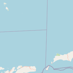
The Wakatobi Archipelago consists of four main islands and approximately 139 smaller islands scattered across tropical seas between the Banda and Flores Seas. The islands feature low-lying terrain with maximum elevations reaching 274 meters on Wangi-Wangi Island, while Lagole Hill on Tomia rises to 271 meters, Terpadu Hill on Binongko reaches 222 meters, and Mount Sampuagiwolo on Kaledupa stands at 203 meters. The surrounding marine environment varies dramatically in depth, with the deepest waters reaching 1,044 meters. The terrestrial landscape includes coastal zones, rolling hills, and limited forested areas, while the underwater terrain features extensive coral reef formations, sandy bottoms, seagrass beds, and steep drop-offs that create diverse marine habitats.
Wakatobi National Park ecosystems, habitats, and plant life
Wakatobi's terrestrial and marine environments support remarkable biodiversity across multiple habitat types. The islands contain mangrove forests, coastal forest, lowland swamp forest, riverbank vegetation, lowland rainforest, and mountain rainforest ecosystems. The marine component features 25 distinct reef groups including fringing reefs, barrier reefs, and atoll formations. Coral diversity is exceptional, with 396 species from 68 genera and 15 families documented, including numerous Acropora species, Pavona cactus, Euphyllia glabrescens, and Stylophora pistillata. The park's position within the Coral Triangle places it at the global center of marine biodiversity, supporting reef systems that far exceed Caribbean or Red Sea diversity.
Wakatobi National Park wildlife and species highlights
The marine wildlife of Wakatobi is extraordinary in both species richness and abundance. Fish diversity includes 942 documented species, representing remarkable density within the reef systems. Sea turtles regularly observed in park waters include hawksbill, loggerhead, and olive ridley populations. Cetaceans including dolphins and whales pass through the archipelago's waters. The islands support seabird populations including brown booby, common kingfisher, and Malaysian plover. The terrestrial environment hosts diverse bird species and smaller fauna typical of Indonesian island ecosystems, though the marine environment remains the primary wildlife attraction.
Wakatobi National Park conservation status and protection priorities
Wakatobi National Park faces significant conservation challenges alongside notable successes. The park's zoned management system designates coral reef areas as no-take zones while allowing traditional fishing in designated areas, though the no-take zones represent only 3.2% of the total marine protected area. Studies have demonstrated that properly enforced no-take areas, such as the Hoga Island site established in 2001, can achieve 80-90% success in preventing fishing activities and show measurable increases in fish biomass, including grouper populations increasing by 31% annually. However, the park struggles with widespread overexploitation, as subsistence fishing provides 70% of local protein needs. Destructive practices including fish bombing and poison fishing continue to impact reef health, while limited enforcement capacity allows widespread noncompliance. Conservation efforts involve the Indonesian government, WWF, and The Nature Conservancy, though community engagement remains challenging.
Wakatobi National Park cultural meaning and human context
The Wakatobi Archipelago is home to approximately 100,000 residents across seven inhabited islands, with the administrative center located in Baubau. The population is predominantly ethnic Wakatobi, with significant Bajau communities comprising about 8% of residents. The Bajau are traditional sea nomads who have inhabited remote Indonesian islands for generations and maintain strong cultural connections to marine resources. This dependence on marine ecosystems creates both challenges and opportunities for conservation, as Bajau fishing practices, including some destructive techniques like fish bombing and coral mining, have historically impacted reef health. Recent conservation initiatives have attempted to engage local communities through reef-leasing schemes and participatory management approaches, though tensions between traditional livelihoods and conservation objectives persist.
Top sights and standout views in Wakatobi National Park
Wakatobi offers exceptional diving and snorkeling opportunities across its extensive reef systems, with visibility often exceeding 30 meters in optimal conditions. The Hoga Island no-take area demonstrates successful marine protection, showing dramatically higher coral coverage and fish abundance compared to heavily fished zones. The park's position in the Coral Triangle provides access to species found nowhere else on Earth, while regular turtle sightings and dolphin encounters add to the marine wildlife experience. The traditional Bajau sea nomad culture provides unique cultural dimension to visits, though respecting conservation boundaries is essential for sustainable tourism.
Best time to visit Wakatobi National Park
The optimal period for visiting Wakatobi National Park generally spans from April to November, when dry conditions provide better visibility for underwater exploration and more comfortable conditions for island activities. The southeast monsoon season from June to August typically offers the calmest seas and clearest water, though this coincides with peak tourism. The wet season from December through March brings reduced visibility but fewer visitors. Water temperatures remain warm throughout the year, typically ranging from 26 to 29 degrees Celsius. Visitors should note that the park's remote location requires advance planning for logistics, and environmental conditions can change rapidly in this tropical marine environment.