

Mori Atlas logo
National parkYamarrinh Wachangan Islands (Denham Group) National Park

Discover mapped boundaries and regional atlas details for this Australian national park.

Yamarrinh Wachangan Islands (Denham Group) National Park: Protected Landscape and Geographic Context in Australia

Yamarrinh Wachangan Islands (Denham Group) National Park represents a significant protected area within Australia's diverse geographic atlas. This page offers an in-depth look at its identity as a national park, focusing on its mapped landscape context and its place within the broader Australian continent. Users can explore the park's protected boundaries and understand its unique geographic features as part of a structured, map-driven discovery of natural areas.

islandsKimberleyWestern AustraliaBonaparte Archipelagocoastal landscapesmarine ecosystems

Yamarrinh Wachangan Islands (Denham Group) National Park

National park

Park overview

Structured park overview, official facts, and landscape profile for Yamarrinh Wachangan Islands (Denham Group) National Park

Yamarrinh Wachangan Islands (Denham Group) National Park park facts, protected area profile, and essential visitor context

Review the core facts for Yamarrinh Wachangan Islands (Denham Group) National Park, including designation, size, terrain, visitor scale, habitats, and operating context in one park-focused overview.

About Yamarrinh Wachangan Islands (Denham Group) National Park

Yamarrinh Wachangan Islands (Denham Group) National Park is situated in the Bonaparte Archipelago off the remote Kimberley coast of northern Western Australia. The park protects a group of islands known as the Denham Group, representing one of the many island clusters in this extensive archipelago. These islands form part of the broader coastal and marine protected area network in the Kimberley region, an area recognized for its outstanding natural values and dramatic landscape character. The park's Indigenous name, Yamarrinh Wachangan, indicates the cultural significance of these islands to traditional owners and reflects the long history of Indigenous connection to the coastal and island landscapes of this region. The surrounding marine environments complement the terrestrial protection, supporting biodiversity in waters that include species important to both ecological and cultural reasons.

Quick facts and research context for Yamarrinh Wachangan Islands (Denham Group) National Park

Located in the Bonaparte Archipelago off the Kimberley coast in northern Western Australia. The Denham Group consists of several islands protected within the national park. The area features typical Kimberley island landscapes including rocky headlands, beaches, and adjacent marine waters. The park supports coastal and marine biodiversity in a region known for its remote, rugged character.

Protection and recognition

Exploring official designation records and international conservation frameworks.

Yamarrinh Wachangan Islands (Denham Group) National Park Protected Area Profile

Navigators can review the documented protection status and management scope of Yamarrinh Wachangan Islands (Denham Group) National Park. Consolidated geographic data provides essential context regarding legal frameworks and international conservation alignments for island reserves.

Protection details

Transboundary protection
No
Park context

Deeper park guide and search-rich context for Yamarrinh Wachangan Islands (Denham Group) National Park

Yamarrinh Wachangan Islands (Denham Group) National Park history, landscape, wildlife, and travel context

Explore Yamarrinh Wachangan Islands (Denham Group) National Park through its history, landscape character, ecosystems, wildlife, conservation priorities, cultural context, and seasonal travel timing in a structured park guide built for atlas discovery and search intent.

Why Yamarrinh Wachangan Islands (Denham Group) National Park stands out

Remote island protection in the Kimberley region, coastal and marine ecosystem preservation, and cultural landscape significance.

Yamarrinh Wachangan Islands (Denham Group) National Park history and protected-area timeline

The formal declaration of Yamarrinh Wachangan Islands (Denham Group) as a national park reflects the broader expansion of protected areas in the Kimberley region during recent decades. The Bonaparte Archipelago and its islands have been subject to various tenure and administrative arrangements, with national park status providing the highest level of terrestrial protection. The establishment of the park contributes to the network of marine and coastal protected areas along the Kimberley coast, a region where conservation planning has increasingly recognized the value of island ecosystems and their associated marine environments.

Yamarrinh Wachangan Islands (Denham Group) National Park landscape and geographic character

The Denham Group islands feature the characteristic landscapes of the Kimberley coast, with rugged sandstone and sandstone-derived substrates forming the islands' underlying geology. Coastal features include rocky headlands, cliffs, and beach formations where wave action and tidal processes shape the shoreline. The islands rise from surrounding seas with limited freshwater resources typical of island environments in this tropical region. Vegetation reflects the island setting with coastal plant communities adapted to the harsh maritime conditions, including exposure to salt spray and seasonal monsoonal weather patterns.

Yamarrinh Wachangan Islands (Denham Group) National Park ecosystems, habitats, and plant life

The islands support coastal and marine ecosystems typical of the Kimberley region. Marine environments surrounding the islands include coral communities, seagrass beds, and productive tidal zones that support diverse fish and invertebrate populations. Birdlife utilizes the islands for nesting and roosting, with seabird colonies established on suitable island habitats. The isolation of these islands contributes to their ecological value, limiting introduced species pressures that affect many mainland areas.

Yamarrinh Wachangan Islands (Denham Group) National Park wildlife and species highlights

The surrounding waters support marine biodiversity including fish species, crustaceans, and other invertebrates that inhabit the coral and rocky reef environments. Seabirds including various tern species, boobies, and frigatebirds utilize the islands for breeding and resting. The marine environment provides foraging habitat for species that depend on productive coastal waters.

Yamarrinh Wachangan Islands (Denham Group) National Park conservation status and protection priorities

The national park status provides statutory protection for the islands' terrestrial and coastal environments. Protection extends to the surrounding marine areas through integrated management approaches that recognize the connection between land and sea in island ecosystems. The park contributes to broader conservation outcomes in the Bonaparte Archipelago, an area recognized for its relatively intact nature and limited development pressure.

Yamarrinh Wachangan Islands (Denham Group) National Park cultural meaning and human context

The Yamarrinh Wachangan name for the islands reflects Indigenous cultural connection to this coastal and island landscape. Traditional owners maintain connections to these islands through ongoing cultural practices and associations. The cultural landscape encompasses both the islands and the surrounding seas, reflecting the integrated view of Country held by Indigenous peoples in this region.

Top sights and standout views in Yamarrinh Wachangan Islands (Denham Group) National Park

Remote island protected area in the Kimberley Bonaparte Archipelago; coastal and marine ecosystem protection; Indigenous cultural landscape with traditional name; contribution to Kimberley conservation network.

Best time to visit Yamarrinh Wachangan Islands (Denham Group) National Park

The dry season from May to October offers more stable weather conditions for visiting the Kimberley region. Conditions during this period include lower humidity and reduced rainfall, making outdoor activities more comfortable. The wet season from November to April brings higher rainfall and humidity, with some access limitations possible due to weather conditions.

Monthly climate preview

Trace long-term representative temperature and precipitation patterns across twelve months

Yamarrinh Wachangan Islands (Denham Group) National Park Climate Normals

Yamarrinh Wachangan Islands (Denham Group) National Park exhibits a measured annual temperature and precipitation rhythm derived from long-term representative point data. Detailed monthly breakdowns provide greater insight into historical temperature ranges and precipitation variations across the protected coordinate.
Annual mean27 °C
25 °C28 °C
Jan28°
Feb28°
Mar28°
Apr28°
May27°
Jun26°
Jul25°
Aug25°
Sep25°
Oct26°
Nov27°
Dec28°
Warmest month
January

28.3 °C

Coolest month
August

24.5 °C

Wettest month
February

12.6 mm/day

Driest month
September

0.2 mm/day

Park location guide

Geography guide, regional context, and park location map for Yamarrinh Wachangan Islands (Denham Group) National Park

Yamarrinh Wachangan Islands (Denham Group) National Park park geography, regions, and map view in Australia

Understand where Yamarrinh Wachangan Islands (Denham Group) National Park sits in Australia through a broader geographic reading of the surrounding landscape, nearby location context, and its mapped position within the national park landscape.

How Yamarrinh Wachangan Islands (Denham Group) National Park fits into Australia

Australia is a constitutional monarchy and federal parliamentary democracy comprising six states and ten territories. With a population of nearly 28 million, it is one of the world's most urbanised countries, with most people concentrated on the eastern seaboard. The country has a high Human Development Index and is known for its cultural diversity, ancient Aboriginal heritage, and unique wildlife.

Wider geography shaping Yamarrinh Wachangan Islands (Denham Group) National Park in Australia

Australia occupies the entire Australian continent, the island of Tasmania, and numerous smaller islands. It is the world's flattest and driest inhabited continent, featuring vast deserts in the interior (the Outback), tropical rainforests along the eastern coast, and a coastline bordering the Indian and Pacific Oceans.

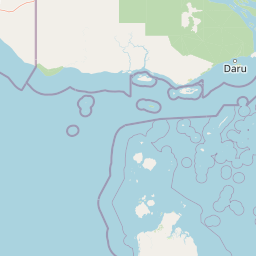
Map view of Yamarrinh Wachangan Islands (Denham Group) National Park

Use this park location map to pinpoint Yamarrinh Wachangan Islands (Denham Group) National Park in Australia, understand its exact geographic position, and read its mapped placement within the surrounding landscape more clearly.

Pigeon | © OpenStreetMap contributors
Park atlas

Compare the unique island and coastal protected areas that define Western Australia's remote Kimberley region.

Other Protected Areas to Compare Near Yamarrinh Wachangan Islands (Denham Group) National Park

Continue your exploration from Yamarrinh Wachangan Islands (Denham Group) National Park by browsing other national parks and protected areas situated within Australia's remote Kimberley region and broader Bonaparte Archipelago. This curated atlas view provides valuable geographic context, enabling direct comparison of diverse coastal and island conservation landscapes and highlighting their regional distribution.
Marine protected areaQueensland
Mapped location lies within the park boundary#1 closest

Southeast

Great Barrier Reef Marine Park: Atlas and Geographic Context for Queensland Protected Waters

Exploring the reef system and marine conservation zones in northeastern Australia

The Great Barrier Reef Marine Park stands as an internationally significant marine protected area. By spanning a massive stretch of the Queensland coast, this protected landscape provides a critical framework for marine governance and reef conservation. Users can examine the unique zoning and distribution of coral reef habitats that define this extensive tropical ecosystem.

Area
343,966 km²
Established
1975
Climate
Tropical
Scope
Marine
National parkQueensland
About 48 km away#2 closest

Southwest

Apudthama National Park: Queensland National Park Protected Landscape Geography

Explore the mapped boundaries and regional context.

Apudthama National Park offers a distinct national park experience within Queensland, Australia, focusing on its protected area identity and geographic landscape. This entry provides critical atlas-level information, detailing the park's mapped boundaries and its position within the regional geography. Understand the specific natural terrain and conservation context of this significant protected land.

Area
2,370 km²
Established
1994
IUCN
II
Relief
Lowland
National parkQueensland
About 68 km away#3 closest

South

Saunders Islands National Park: National Park Geography and Mapped Protected Landscape in Queensland

Explore the mapped terrain and protected area context.

Saunders Islands National Park represents a significant protected area within the geography of Queensland, Australia. This entry provides detailed atlas-level insights into its specific geographic boundaries and the nature of its protected landscape. Users can understand the park's regional placement and its mapped natural terrain, offering a concrete point for exploring Queensland's diverse protected lands and their unique environmental characteristics.

Area
0.19 km²
Established
1989
IUCN
II
Climate
Tropical
National parkAustralia
About 80 km away#4 closest

Northwest

Possession Island National Park: National Park Atlas and Mapped Geographic Context

Australia's protected natural terrain and park boundaries.

Possession Island National Park serves as a vital point of discovery for understanding Australia's protected lands. This national park provides detailed insights into its specific geographic setting and landscape character, contributing to a broader atlas of natural territories. Engage with its mapped boundaries and unique terrain to grasp its significance within the country's conservation landscape. It is an essential component for anyone exploring the geography of Australian national parks.

National parkQueensland
About 100 km away#5 closest

Southeast

Sir Charles Hardy Group National Park: Queensland National Park Atlas and Geography

Explore its mapped protected landscape and regional context.

Sir Charles Hardy Group National Park serves as a vital protected area within Queensland, Australia. This entry offers an atlas-centric view, detailing the park's mapped boundaries and its contribution to the regional geography. Examine its significance as a national park and understand the natural terrain it encompasses within northeastern Australia.

Area
1.29 km²
Established
1989
IUCN
II
Scope
Terrestrial
National parkQueensland
About 126 km away#6 closest

South

Piper Islands National Park: Queensland National Park with Critical Seabird Colonies

Explore mapped boundaries and landscape context for this Great Barrier Reef island sanctuary.

Piper Islands National Park in Queensland is a protected area comprising four coral cays vital for significant seabird nesting populations. Recognized as an Important Bird Area, these islands showcase distinct mangrove and Pisonia forest ecosystems against the backdrop of the inner northern Great Barrier Reef. The park's protected landscape offers a unique glimpse into the ecological importance of these small, dynamic coastal landforms within a world-heritage marine setting.

Area
0.07 km²
Established
1989
IUCN
II
Relief
Lowland
National parkQueensland
About 137 km away#7 closest

South

Wuthara Island National Park: Protected Island Geography in Queensland's Coral Sea

Explore mapped coastal landscape and protected area context.

Wuthara Island National Park is a significant protected area located in the Coral Sea, contributing to Queensland's network of national parks. Its island geography and position within the Great Barrier Reef Marine Park region offer a unique perspective on coastal landscape conservation. This page provides detailed information to help users understand the park's role as a protected national park and its specific contribution to the mapped geography of tropical Australia.

Area
1.09 km²
Established
1990
IUCN
II
Relief
Lowland
National parkQueensland
About 152 km away#8 closest

South

Mitirinchi Island National Park: A Queensland National Park with Defined Protected Boundaries

Explore its unique Queensland geography and natural landscape.

Mitirinchi Island National Park is a designated national park located within Queensland, Australia, offering a specific point of focus for geographic and atlas exploration. This entity contributes to the understanding of protected land distribution across the northeastern Australian region. Examining Mitirinchi Island National Park allows for detailed appreciation of its mapped terrain and its role as a conservation landscape within the broader Queensland geography.

Area
0.012 km²
Established
1989
IUCN
II
Relief
Lowland

Common questions about visiting, size, designation, and location context for Yamarrinh Wachangan Islands (Denham Group) National Park

Yamarrinh Wachangan Islands (Denham Group) National Park FAQs for park facts, access, geography, and protected area context

Find quick answers about Yamarrinh Wachangan Islands (Denham Group) National Park, including protected-area facts, park geography, trail and visitor context, and how the park fits into its surrounding country and regional landscape.
MoriAtlas Explorer

Continue Your Protected Areas Search Across the Global Atlas

Deepen your exploration by continuing the structured search for national parks and protected areas worldwide. Utilize the comprehensive filtering capabilities to compare different conservation landscapes and refine your understanding of global park geography. Discover more about the distribution and characteristics of protected natural areas.

Global natural geography