Why Yendegaia National Park stands out
Yendegaia is renowned for protecting the last remaining sub-Antarctic beech forest remnants on Earth, a living relic of the ancient Gondwana supercontinent. The park contains exceptional biodiversity within the Magellanic subpolar forest ecoregion, sheltering species such as lenga, canelo, and coigüe trees, alongside endangered wildlife including the culpeo fox, river otter, and ruddy-headed goose. The dramatic glaciated landscape of the Darwin Range, with its towering peaks and retreating glaciers feeding fjords and lakes, provides one of Patagonia's most spectacular mountain wilderness settings. The park also represents a pioneering model of conservation through its creation via private land donation to the state, forming a potential transfrontier peace park with Argentina.
Yendegaia National Park history and protected-area timeline
Yendegaia National Park emerged from a visionary conservation initiative conceived in 2011 as part of Chile's Bicentennial celebrations. The project originated with the Yendegaia Foundation, established by American entrepreneur Douglas Tompkins and his wife Kris Tompkins, who had acquired the Estancia Yendegaia property in 1998. This former livestock and forestry operation was gradually transformed into a private protected area with the ultimate goal of transferring the land to the Chilean state. In 2013, the foundation donated 38,780 hectares to the Chilean government, which combined with 111,832 hectares of existing state lands to create the new national park. The formal declaration occurred in December 2013, though administrative processes and official park establishment continued into 2016. Tragically, Douglas Tompkins passed away in December 2015 before seeing the park fully operational, but his wife Kris Tompkins continued the conservation legacy. The park's creation also enabled discussions with Argentina regarding a transfrontier peace park linking Yendegaia with the adjacent Tierra del Fuego National Park across the border.
Yendegaia National Park landscape and geographic character
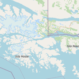
The physical landscape of Yendegaia National Park displays the dramatic terrain characteristic of southern Patagonia, shaped by glacial processes and ongoing tectonic activity. The park encompasses the eastern portion of the Cordillera Darwin, the southernmost major mountain range of the Andes, with peaks and ridges rising above the tree line. Glaciers descend from these heights into the valley systems, feeding numerous lakes, rivers, and the distinctive fjord landscapes that indent the coast. The Yendegaia Valley provides a relatively flatter corridor through the mountainous terrain, while the broader park includes portions of the Fagnano Lake basin and the Azopardo River drainage. The Beagle Channel forms the park's southern boundary, where coastal features include bays, coves, and shoreline areas influenced by tidal cycles. The landscape transitions from forested lower elevations through subalpine zones to alpine terrain and permanent snow fields, creating a vertically diverse topographic environment.
Yendegaia National Park ecosystems, habitats, and plant life
The ecological character of Yendegaia centers on the Magellanic subpolar forest, one of the southernmost temperate forest ecosystems on Earth. This forest type represents a descendant of the ancient forests that covered Gondwana before the continental breakup, containing plant lineages that have persisted for approximately 180 million years. The forest composition varies with elevation and exposure: coastal lower elevations feature evergreen coihue (Nothofagus betuloides), while higher areas transition to deciduous lenga (Nothofagus pumilio), with ñirre (Nothofagus antarctica) appearing in wetter northern sections. Canelo (Drimys winteri) and coigüe (Nothofagus dombeyi) add to the forest diversity. Above the tree line, the austral Andean steppe dominates with grasses and shrubs adapted to harsh conditions. The surrounding marine waters belong to the channels and fjords ecoregion of southern Chile, while freshwater systems drain into the Patagonia freshwater ecoregion.
Yendegaia National Park wildlife and species highlights
Yendegaia supports a rich fauna community reflecting the diverse habitats within the park. The mammalian fauna includes the guanaco, which remains abundant across the steppe and forest margins, and the culpeo fox, a species now endangered in Chile. The river otter inhabits freshwater systems throughout the park. Marine mammals frequent the Beagle Channel coastlines, including South American sea lions and fur seals, with occasional leopard seal sightings. Cetaceans such as dusky dolphins and the rarer Chilean dolphin may be observed offshore. The bird population is particularly diverse, with 49 documented species including the Magellanic woodpecker, a characteristic forest species, and the Andean condor soaring over mountainous areas. Coastal waters support colonies of imperial cormorants, rock cormorants, and various waterfowl including the flightless steamer duck. The park also contains non-native species introduced during European colonization, including American beavers whose dam-building activities have significantly impacted local waterways.
Yendegaia National Park conservation status and protection priorities
Yendegaia National Park plays a crucial role in conserving some of the planet's most southerly remaining old-growth forests and the unique biodiversity they contain. The protection of these sub-Antarctic beech forests addresses a critical conservation priority, as they represent the last substantial remnants of this ecosystem type. The park's inclusion within the Cape Horn Biosphere Reserve reinforces its significance within broader regional conservation frameworks. The creation of Yendegaia also contributes to the goal of establishing a transfrontier peace park spanning the Chile-Argentina border, which would create one of the largest contiguous protected areas in southern South America. Conservation challenges include managing introduced species, particularly American beavers that have caused extensive ecosystem disruption, and maintaining the park's pristine character as visitation increases. The park protects habitat for three endangered species, the culpeo fox, river otter, and ruddy-headed goose, providing them refuge within its boundaries.
Yendegaia National Park cultural meaning and human context
The lands of Yendegaia National Park carry deep cultural significance as the ancestral territory of the Yagán (Yámana) people, indigenous hunter-gatherers who inhabited the islands of Tierra del Fuego for thousands of years. The Yagán were maritime-oriented cultures renowned for their sophisticated boat-building and seafaring skills,依存ing heavily on marine resources from the Beagle Channel and adjacent waters. Visible evidence of this long human occupation remains along the park's coastlines, where ancient shell middens attest to the consumption of marine mollusks by Yagán communities. These archaeological sites represent important cultural heritage requiring protection alongside the natural values. The more recent history of the area includes the establishment of Estancia Yendegaia as a sheep ranch during the European colonization period, the remains of which now stand abandoned within the park as a reminder of the landscape's transitional history.
Top sights and standout views in Yendegaia National Park
The defining highlight of Yendegaia National Park is its spectacular glaciated mountain scenery within the Darwin Range, where peaks and glaciers descend into forested valleys and fjords. The park offers the rare opportunity to explore some of the world's southernmost remaining old-growth forests, with trees representing ancient Gondwanan lineages. The transboundary location creating a potential peace park with Argentina represents a landmark achievement in international conservation cooperation. The Yendegaia Valley provides the most accessible exploration corridor within this remote wilderness. The diversity of environments within a single park, from coastal marine areas through forest and steppe to alpine terrain, supports remarkable ecological richness. The park's recent establishment means much of its trail infrastructure remains under development, offering adventurous visitors a relatively untouched wilderness experience.
Best time to visit Yendegaia National Park
The optimal visiting period for Yendegaia National Park occurs during the Patagonian summer months from December through March, when temperatures are mildest and daylight hours are longest. Summer conditions feature temperatures occasionally reaching 24°C but more typically ranging between 10°C and 18°C, with long days enabling extended exploration. However, the subpolar oceanic climate means weather remains highly variable regardless of season, with frequent rain, overcast skies, and rapid conditions changes common throughout the year. Winter months from June to September bring significantly colder conditions, with temperatures potentially dropping to -11°C and substantial snowfall transforming the landscape. The shoulder seasons of spring and autumn offer fewer visitors but more unpredictable weather. Year-round, visitors should prepare for the possibility of inclement conditions and the characteristic Patagonian wind that can dramatically affect perceived temperatures.