Mori Atlas logo
Protected areaAiluk Atoll

Mapping the low-lying coral islets, lagoon ecosystems, and volcanic foundation of a remote Pacific atoll.

Ailuk Atoll Protected Area and Coral Reef Geography in the Marshall Islands Ratak Chain

Ailuk Atoll represents a classic North Pacific coral ring located within the Ratak Chain of the Marshall Islands. This protected area consists of 57 small islets encircling a spacious interior lagoon that remains vital to local maritime traditions and marine biology. The landscape features a distinct zonation from coconut and pandanus forests on the lagoon-facing shores to salt-sculpted scrub on the ocean-exposed margins, all built upon the ancient basalt remnants of a subsided volcanic seamount.

coral atollPacific atollMarshall IslandsRatak Chaininhabited atolllagoon ecosystem

Ailuk Atoll

Protected area

Park overview

Structured park overview, official facts, and landscape profile for Ailuk Atoll

Ailuk Atoll park facts, protected area profile, and essential visitor context

Review the core facts for Ailuk Atoll, including designation, size, terrain, visitor scale, habitats, and operating context in one park-focused overview.

About Ailuk Atoll

Ailuk Atoll lies in the northern portion of the Ratak Chain of the Marshall Islands, roughly midway in the country’s east–west island arc. From the air it has the classic form of a Pacific coral atoll: a discontinuous ring of low, narrow islets arranged around a roughly circular lagoon, with reef structures dominating the western and southern flanks. The atoll sits about 72 kilometers north of Wotje and 92 kilometers south of Utirik, and is several hundred kilometers north of Majuro, the national capital.

Geologically, Ailuk is a textbook example of how Marshall Islands atolls have formed. The structure is believed to rest on a very thick cap of reef limestone laid down over a basalt base that itself sits atop an extinct submarine volcano rising several thousand meters from the surrounding ocean floor. As the underlying volcanic edifice has slowly subsided, coral growth has kept pace, building up the thick reef foundation observed on neighboring atolls such as Enewetak.

Above the sea, Ailuk is a deeply humanized landscape. Two thousand years of continuous habitation have reshaped the natural vegetation, and today coconut palms, breadfruit, pandanus, and bananas are the dominant visible plants around homes and settlements. Beyond the inhabited core, the eastern islets show a clear ecological zonation: coconut groves facing the lagoon give way to dense mixed forest of Guettarda, Pandanus, Tournefortia, and Scaevola, which then narrows seaward into a hardier scrub before reaching the exposed ocean shoreline.

The people of Ailuk remain closely tied to the sea. The atoll is unusual within the Marshall Islands for still commonly using traditional sailing outrigger canoes for inter-islet transport and fishing, reducing its dependence on imported fuel and engine parts. Small communities on the islets of Ailuk and Enejelar provide the core of local life, supported by elementary schools, basic medical facilities, solar-powered households, and a small airstrip connecting the atoll to the rest of the country.

Quick facts and research context for Ailuk Atoll

Ailuk Atoll is part of the Ratak Chain of the Marshall Islands, located roughly between Wotje to the south and Utirik to the north in the North Pacific Ocean. The atoll consists of 57 islets enclosing a large lagoon, with a total land area of about 5 square kilometers. Its highest point is only around 3 meters above sea level, making it one of the very low-lying Marshallese atolls.

The atoll has been inhabited for roughly 2,000 years by Marshallese communities and today has a small resident population concentrated on the main islets of Ailuk and Enejelar. The nearby capital Majuro lies several hundred kilometers to the south, underscoring Ailuk’s remote character within the country.

Protection and recognition

Examine the documented marine protection scope and designation records for Ailuk Atoll.

Ailuk Atoll Protection Status and Marine Conservation Frameworks

Marine protection scope definitions outline the documented conservation framework established for Ailuk Atoll. Available designation records capture official management boundaries and international recognition data without assuming broader ecological outcomes.

Protection details

Protection scope
Marine
Transboundary protection
No
Park context

Deeper park guide and search-rich context for Ailuk Atoll

Ailuk Atoll history, landscape, wildlife, and travel context

Explore Ailuk Atoll through its history, landscape character, ecosystems, wildlife, conservation priorities, cultural context, and seasonal travel timing in a structured park guide built for atlas discovery and search intent.

Why Ailuk Atoll stands out

Ailuk is known for being a small but classic Pacific coral atoll with a ring of islets surrounding a spacious lagoon. It is distinguished within the Marshall Islands by its continued reliance on traditional Marshallese sailing outrigger canoes for inter-islet travel and fishing, rather than motorized boats. The atoll is also noted for its well-defined vegetation zonation, from coconut groves on lagoon-facing shores to wind- and salt-sculpted Pemphis and Suriana scrub on the ocean-facing edges.
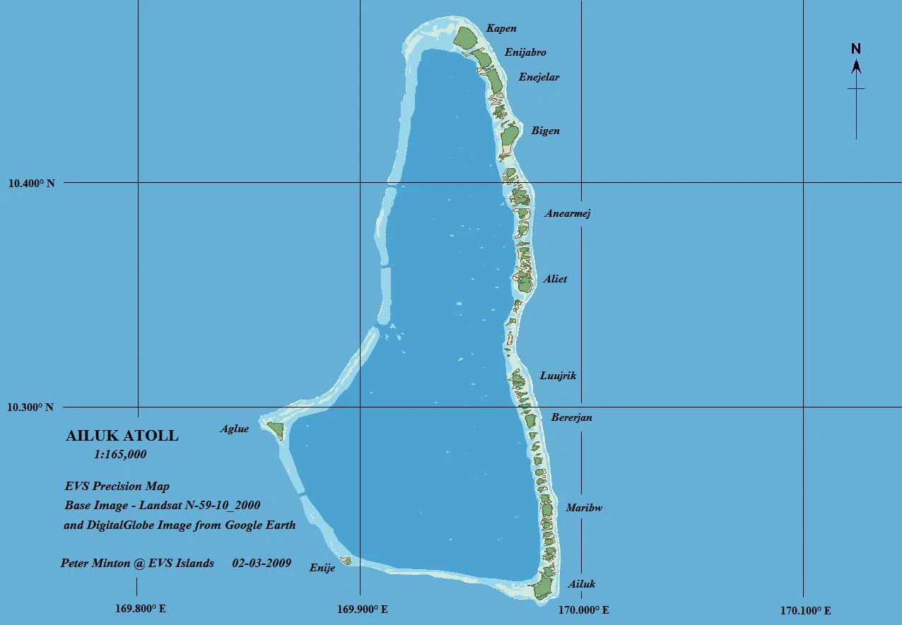
A nautical style map showing the coral structure and individual islets of Ailuk Atoll, with a grid and labels.
A geographic reference map of Ailuk Atoll showing its various islets, lagoon shape, and coordinate grid.

Ailuk Atoll history and protected-area timeline

Ailuk Atoll has been inhabited for roughly two millennia. About two thousand years ago, Oceanic-speaking peoples associated with late Lapita cultural traditions migrated from the Solomon Islands region, settling the volcanic islands of central Micronesia and eventually colonizing the Marshall Islands atolls, including Ailuk.

The first documented European contact came on 10 January 1565, when the Spanish expedition led by Miguel López de Legazpi sighted the atoll and charted it as Los Placeres. Two of its islets were recorded under the names San Pedro and San Pablo, taken from the expedition’s flagship and secondary vessel. In the colonial era of the late nineteenth century, Ailuk became part of the Marshall Islands under the German Empire, which claimed the archipelago in 1885.

Following the First World War, the atoll passed to the Empire of Japan under the South Seas Mandate. After the Second World War, it came under United States administration as part of the Trust Territory of the Pacific Islands. Ailuk has been part of the independent Republic of the Marshall Islands since the country’s independence in 1986, continuing to function as a small legislative district within the national structure.

Ailuk Atoll landscape and geographic character

Ailuk presents the classic geological and visual profile of a North Pacific coral atoll. The rim is composed of 57 small islets, most clustered on the eastern side of the ring, while the western and southern portions of the atoll are defined by a nearly continuous submerged reef rather than dry land. The dry land above sea level covers only a few square kilometers, and the highest points on the atoll rise just a few meters above the ocean, giving the entire landscape a uniformly low, flat character.

Inside the reef, the atoll encloses a broad lagoon that is many times larger than the total land area. Three main reef passes, Erappu, Marok, and Eneneman, cut through the western reef and provide the primary entrances to the lagoon. The combination of broad lagoon, narrow islets, and shallow reef flats shapes both the marine environment and the patterns of human settlement.

Beyond the reef edge, Ailuk is also a geological structure of surprising scale. Based on comparisons with drilling data from neighboring Enewetak Atoll, the reef cap at Ailuk is inferred to be extremely thick, built atop a basalt foundation that covers an extinct volcanic seamount rising thousands of meters from the ocean floor. The slow subsidence of that volcanic edifice over millions of years has allowed coral growth to keep pace, gradually constructing the atoll seen at the surface today.

Ailuk Atoll ecosystems, habitats, and plant life

The natural vegetation of Ailuk has been shaped both by its physical setting and by long-term human habitation. The Marshall Islands lie within the Northeast Trade Wind belt, and Ailuk’s position near the northern end of the country places it in a relatively drier climatic zone for atolls. Consistent northeast to east winds, high humidity, and warm year-round temperatures create a tropical rainforest climate, but reduced rainfall at higher latitudes limits overall plant diversity compared with atolls closer to the equator.

On the inhabited and most accessible islets, the natural plant communities have been substantially modified. Tree crops such as breadfruit, coconut, pandanus, and banana dominate the area around homes, and most households rely on these staples for daily subsistence. The narrow strips of cultivable soil and limited fresh water strongly restrict what can be grown, reinforcing the importance of tree crops over ground cultivation.

Away from settlements, the eastern islets display a clear vegetation gradient. Lagoon-facing shores are often planted with coconut palms, which give way inland to a crescent of dense mixed forest dominated by Guettarda, Pandanus, Tournefortia, and Scaevola taccada. Seaward, this forest thins into a low Scaevola scrub, before transitioning along reef-margin beaches into tough shrubs such as Suriana and Pemphis. The outermost windward shoreline is typically a beaten-down scrub of gnarled Pemphis and Suriana, sometimes mixed with Tournefortia and Scaevola, defining the boundary between land and reef.

Ailuk Atoll wildlife and species highlights

Ailuk’s wildlife reflects its identity as a remote Pacific atoll, with seabirds and shorebirds dominating the fauna. Common resident seabirds include the Red-tailed Tropicbird, Red-footed Booby, Sooty Tern, White Tern, Brown Noddy, and Black Noddy, which likely nest on the more lightly vegetated islets and reef margins around the atoll ring.

A wide variety of shorebirds and land birds are also regularly present around Ailuk, including the Reef Heron, Golden Plover, Whimbrel, Bristle-thighed Curlew, Bar-tailed Godwit, Wandering Tattler, Ruddy Turnstone, Sanderling, and Sharp-tailed Sandpiper, as well as the Long-tailed New Zealand Cuckoo. Introduced species such as the domestic chicken and ground dove have become part of the atoll’s everyday birdlife alongside these native and migratory species.

The surrounding waters, including the lagoon and reef passes, support the fishing culture that remains central to life at Ailuk. The atoll’s continued reliance on traditional sailing outrigger canoes reflects both limited motorized infrastructure and the ongoing abundance of marine resources close to home.

Ailuk Atoll conservation status and protection priorities

Ailuk’s ecological value lies primarily in its function as a functioning Pacific coral atoll ecosystem within the Ratak Chain, offering habitat for both resident seabirds and migratory shorebirds. Its reef cap, deep lagoon passes, and surrounding ocean support the marine productivity that underwrites the food security and cultural identity of its communities. The persistence of traditional sailing-based fishing and inter-islet transport also reflects an adaptive, low-impact relationship with the surrounding marine environment.

Like other low-lying Marshall Islands atolls, Ailuk is inherently vulnerable to climate-related pressures such as sea-level rise, changing rainfall patterns, and the increasing intensity of storms, all of which shape the long-term outlook for both its natural vegetation and its freshwater-limited habitats. The combination of human-modified vegetation, restricted plant diversity at its latitude, and dependence on coconut, breadfruit, and pandanus underscores the importance of maintaining healthy reef and soil systems for the atoll’s continued habitability.

Ailuk Atoll cultural meaning and human context

Ailuk’s cultural fabric is deeply rooted in Marshallese identity and a long maritime tradition. The atoll’s population of a few hundred people, concentrated on the islets of Ailuk and Enejelar, continues to rely heavily on the sea for daily life, including fishing and travel between islets. The continued common use of traditional sailing outrigger canoes across the Ratak Chain is one of Ailuk’s most distinctive cultural markers and reflects the community’s connection to ancestral navigation and voyaging practices.

Household life is oriented around tree-crop cultivation, with breadfruit, coconut, pandanus, and bananas providing the primary plant-based subsistence. Community infrastructure is modest and decentralized: each of the two main islets has an elementary school and basic medical facilities, households depend on solar power for lighting, and the Ailuk City Hall serves as a shared space for community meetings and light administrative functions. The atoll’s relative isolation, combined with its strong traditional practices, gives it a clear sense of place within the broader Marshallese cultural landscape.

Top sights and standout views in Ailuk Atoll

Ailuk Atoll offers a compact but well-defined expression of Marshallese atoll life, combining a classic coral-ring profile, a spacious interior lagoon, and a long history of continuous habitation stretching back roughly two thousand years. Its combination of dry-land islets, reef passes, and ocean-facing reef makes it a useful example of how the atolls of the Ratak Chain are structured.

Equally notable is the atoll’s living maritime culture: a small population that still uses traditional sailing outrigger canoes for much of its inter-islet travel and fishing, and that maintains a subsistence pattern built around coconuts, breadfruit, pandanus, and bananas. The mix of resident seabirds and migratory shorebirds, together with the layered plant communities from coconut groves to windward Pemphis scrub, rounds out Ailuk’s profile as a distinct and characteristic part of the Marshall Islands.

Best time to visit Ailuk Atoll

Ailuk has a tropical rainforest climate with warm temperatures year-round, generally between the mid-20s and high 20s Celsius, so seasonal variation is modest. The driest months tend to be January and February, with comparatively lower rainfall, while August through October bring the heaviest rains of the year and the most prolonged rainy days. The middle of the year, around July, sees the most rainy days but also the highest sunshine hours.

Visitors sensitive to wet conditions may prefer the relatively drier early months of the year, while those interested in lush conditions, greener vegetation, and more active birdlife may favor the wetter late-summer and early-autumn period. Because the atoll lies within the Northeast Trade Wind belt, easterly winds are a constant feature throughout the year.

Monthly climate preview

Long-term representative point measurements tracking monthly weather patterns

Ailuk Atoll Climate Normals, Annual Temperature and Monthly Precipitation Rhythms

Historical data records consistent monthly temperatures alongside a distinct annual precipitation cycle across the representative coordinate. Examining the complete twelve-month normals profile reveals detailed temperature and rainfall variations for geographic context.
Annual mean28 °C
27 °C28 °C
Jan27°
Feb27°
Mar27°
Apr27°
May28°
Jun28°
Jul28°
Aug28°
Sep28°
Oct28°
Nov28°
Dec28°
Warmest month
September

28.1 °C

Coolest month
February

26.9 °C

Wettest month
October

5.7 mm/day

Driest month
February

1 mm/day

Park location guide

Geography guide, regional context, and park location map for Ailuk Atoll

Ailuk Atoll park geography, regions, and map view in Marshall Islands

Understand where Ailuk Atoll sits in Marshall Islands through a broader geographic reading of the surrounding landscape, nearby location context, and its mapped position within the national park landscape.

How Ailuk Atoll fits into Marshall Islands

The Marshall Islands is a sovereign island nation in Oceania, located in the Micronesia region of the Northwestern Pacific Ocean. The territory consists of 29 coral atolls and five main islands plus over 1,200 very small ones, divided across two island chains: Ratak in the east and Ralik in the west. The country gained independence from the United States in 1979 and maintains a Compact of Free Association with the US. It is notable for having the highest proportion of water to land of any sovereign state, at 98.62%.

Wider geography shaping Ailuk Atoll in Marshall Islands

The Marshall Islands is located in the Micronesia region of the Northwestern Pacific Ocean, west of the International Date Line and north of the equator. The territory is composed of 29 coral atolls and five main islands, plus approximately 1,220 very small islets, divided into two island chains: Ratak (eastern) and Ralik (western). Maritime boundaries are shared with Wake Island to the north, Kiribati to the southeast, Nauru to the south, and the Federated States of Micronesia to the west.

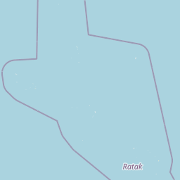
Map view of Ailuk Atoll

Use this park location map to pinpoint Ailuk Atoll in Marshall Islands, understand its exact geographic position, and read its mapped placement within the surrounding landscape more clearly.

Pigeon | © OpenStreetMap contributors

Visualizing coral rings, lagoon ecosystems, and low-lying Pacific terrain

Ailuk Atoll Photos and Protected Landscape Scenery

Photographic records reveal the distinct geological profile and coastal habitats of Ailuk Atoll. Visual exploration highlights the delicate balance between the broad lagoon and the surrounding chain of small islets.

A nautical style map showing the coral structure and individual islets of Ailuk Atoll, with a grid and labels.

A small traditional sailing canoe with a triangular sail moving across deep blue open water.

Park atlas

Compare connected coral atolls, marine environments, and regional island geography.

Other Parks Near Ailuk Atoll and Protected Areas in the Surrounding Region

Browsing other parks near Ailuk Atoll provides immediate context for regional marine reserves and low-lying island ecosystems across the central Pacific. Comparing adjacent protected areas reveals broader geological patterns and shared coastal environments throughout the surrounding archipelagos.
Watercolor painting of a landscape showing a body of water surrounded by green land with trees and distant hills, with soft pink and purple washes on the sides
Protected areaMarshall Islands
About 100 km away#1 closest

Southwest

Likiep Atoll: A Mapped Protected Area in the Marshall Islands Ratak Chain

Coral atoll geography and historical colonial landscape features

Likiep Atoll consists of 65 islands encircling a 424 square kilometer lagoon. As a protected area in the Marshall Islands, it offers insight into low lying atoll topography, unique marine environments, and the cultural remnants of successive colonial administrations.

Area
10.26 km²
Relief
Lowland
Climate
Tropical
Access
Remote access
Protected areaMarshall Islands
About 212 km away#2 closest

North

Bikar Atoll Protected Area: Geographic Overview of a Remote Marshall Islands Coral Atoll

A pristine, uninhabited coral sanctuary and critical Pacific marine habitat.

Bikar Atoll is a remote, diamond-shaped coral ring located in the Ratak Chain of the Marshall Islands. Defined by its shallow lagoon, continuous reef structure, and arid islets, the atoll serves as a vital nesting site for seabirds and green turtles. This protected area remains one of the most ecologically undisturbed sites in the Pacific, offering rare insight into natural atoll morphology and island conservation.

Area
0.5 km²
Established
2025
Relief
Lowland
Climate
Tropical
Protected areaMarshall Islands
About 293 km away#3 closest

West

Rongerik Atoll Protected Area: Mapping the Marshall Islands Coral Landscape

Remote coral atoll geography and lagoon structures in the Ralik Chain.

Rongerik Atoll presents a textbook example of Pacific atoll geography, where a cluster of small islets encloses an expansive lagoon. As a protected area located in the remote Marshall Islands, this site serves as a vital point of study for understanding coral reef systems and the isolated island terrain of the Ralik Chain. The landscape provides clear insights into the physical contrast between narrow coral landmasses and the deep interior waters characteristic of the region.

Area
1.68 km²
Relief
Lowland
Climate
Tropical
Access
Remote access
A pale, soft watercolor illustration depicting distant islands or atoll ridges across a calm lagoon, with silhouetted palm trees in the foreground on the left and right.
Protected areaMarshall Islands
About 300 km away#4 closest

Southwest

Kwajalein Atoll Protected Area and Marshall Islands Geographic Landscape Mapping

Pacific coral atoll structure and lagoon geography

Kwajalein Atoll represents a mature coral formation encompassing an immense lagoon within the Ralik Chain. The landscape consists of low-lying islets and interconnected reef structures that define the maritime geography of the Marshall Islands. This assessment provides a focus on the structural, mapped, and physical attributes that distinguish this protected site within the wider Pacific regional context.

Area
16.4 km²
Relief
Lowland
Climate
Tropical
Access
Highly restricted
A minimalist watercolor painting featuring soft, light green hills in the foreground and faded, purple-toned mountains in the distant background, all set against a white backdrop.
Protected areaMarshall Islands
About 361 km away#5 closest

West

Rongelap Atoll Protected Area: Geography, Reef Structure, and Marshall Islands Context

Coral atoll terrain in the Pacific Ralik Chain

Located in the Ralik Chain of the Marshall Islands, Rongelap Atoll consists of 61 low-lying coral motus that enclose a lagoon covering 2,600 square kilometers. The atoll serves as a significant geographic study area, known for its distinct reef-built structure and its enduring role in Pacific history. This protected area continues to represent the ecological and cultural complexity of the Micronesian archipelago.

Area
21 km²
Relief
Lowland
Climate
Tropical
Access
Remote access
A watercolor painting showing a panoramic view of soft, green rolling hills, a cluster of trees, and a calm water surface in a light, muted palette.
Protected areaMarshall Islands
About 393 km away#6 closest

Southeast

Majuro: Mapping the Protected Coral Atoll Landscapes and Island Geography of the Marshall Islands

Regional atoll atlas and protected lagoon geography.

Majuro serves as the primary administrative and geographic anchor within the Marshall Islands. This detailed mapping showcases the atoll's signature structure, characterized by 64 narrow islets enclosing a massive, sheltered 295 square kilometer lagoon. Delve into the specific landforms and regional marine geography that define this Pacific protected environment.

Area
9.7 km²
Relief
Lowland
Climate
Tropical
Access
Moderate access
Protected areaMarshall Islands
About 405 km away#7 closest

West

Ailinginae Atoll Protected Area: Geographic Overview and Mapped Lagoon Systems

Remote coral atoll landscape in the Marshall Islands

Uncover the geographic structure of Ailinginae Atoll, an uninhabited coral ring in the Marshall Islands characterized by its expansive internal lagoon and narrow island segments. This protected area offers significant insight into the terrain of low-lying Pacific atoll ecosystems and their role within the Ralik Chain geographic framework.

Area
2.8 km²
Relief
Lowland
Water
Water-dominated
Protected areaMarshall Islands
About 408 km away#8 closest

Southeast

Arno Atoll: A Rare Triple Lagoon Coral Protected Area in the Marshall Islands

Mapped geography and hydrological landscape context

Arno Atoll stands out as a unique geographic entity in the Ratak Chain with its triple lagoon configuration. Spanning 133 islands in the North Pacific, this protected area offers insight into atoll reef systems, low lying coral landscapes, and the environmental framework of the Marshall Islands.

Area
13 km²
Relief
Lowland
Climate
Tropical
Scope
Mixed

Common questions about visiting, size, designation, and location context for Ailuk Atoll

Ailuk Atoll FAQs for park facts, access, geography, and protected area context

Find quick answers about Ailuk Atoll, including protected-area facts, park geography, trail and visitor context, and how the park fits into its surrounding country and regional landscape.
MoriAtlas Explorer

Continue Your Protected Areas Search Across the Global Atlas

Deepen your exploration by continuing the structured search for national parks and protected areas worldwide. Utilize the comprehensive filtering capabilities to compare different conservation landscapes and refine your understanding of global park geography. Discover more about the distribution and characteristics of protected natural areas.

Global natural geography