Why Akan Mashu National Park stands out
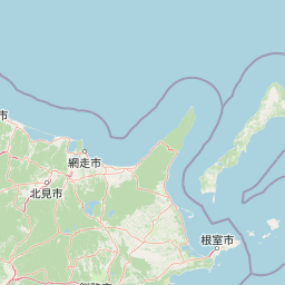
Akan Mashu National Park is renowned for its exceptional clarity in Lake Mashū, one of the world's clearest freshwater lakes, and as the exclusive natural habitat in Japan where large marimo algae grow. The park's volcanic landscape features dramatic caldera formations, steaming fumaroles, boiling mud pools known as bokke, and hot springs that have shaped both the physical terrain and the area's cultural identity. The Akan Caldera, spanning over 20 kilometers across, forms the park's geographic heart, while Mount Meakan serves as a prominent volcanic landmark rising from the caldera floor.
Akan Mashu National Park history and protected-area timeline
Akan Mashu National Park was established on December 4, 1934, marking it as one of the earliest national parks created in Hokkaido and among Japan's first generation of protected landscapes. The park's creation reflected Japan's growing interest in preserving outstanding natural areas during the early twentieth century, with particular attention given to areas combining geological significance, scenic beauty, and unique ecological features. The selection of Akan and Mashu as park names reflects the two major geographic regions that were incorporated into the protected area. Over the decades, the park has maintained its protected status while evolving its management approaches to address changing conservation priorities and visitor use patterns. The continued protection of the marimo populations and the park's exceptional lake clarity have remained central to the park's conservation identity since establishment.
Akan Mashu National Park landscape and geographic character
The physical landscape of Akan Mashu National Park is fundamentally shaped by volcanic activity, with caldera formations, volcanic peaks, and hydrothermal features defining the terrain. The Kawayu area features Lake Kussharo, a substantial caldera lake surrounded by volcanic heights including Mount Mokoto, Mount Nishibetsu, and the Bihoro Pass overlook. Mount Iō dominates the Kawayu region with its active fumaroles and sulfur emissions, demonstrating the ongoing geothermal processes beneath the park. The Akan area centers on the enormous Akan Caldera, measuring over 20 kilometers in diameter, within which rises the Akan Volcanic Complex. Mount Meakan stands as the park's highest point, an active volcano that anchors the southern landscape. Lake Mashū fills a separate caldera and presents one of Japan's most visually striking lake scenes, its deep blue waters contrasting with the surrounding volcanic ridges. The Wakoto Peninsula juts into Lake Kussharo with thermal areas where ground temperatures remain elevated enough to influence local ecology.
Akan Mashu National Park ecosystems, habitats, and plant life
The ecological character of Akan Mashu National Park reflects its volcanic setting, high-latitude position, and the presence of exceptional freshwater environments. The park's lakes support unique aquatic communities, with Lake Mashū's extraordinary clarity indicating a relatively oligotrophic environment with minimal nutrient input and limited suspended particles. The marimo populations in Lake Akan represent a botanical phenomenon unique to this location within Japan, where spherical colonies of Aegagropila linnaei algae grow to sizes found nowhere else in the country naturally. Forest ecosystems throughout the park feature species adapted to Hokkaido's cooler continental climate, including mixed communities of deciduous broadleaf trees and conifers. Wetlands and marshy areas occur around lake margins and along stream corridors, providing habitat diversity within the predominantly volcanic terrain. The hydrothermal areas with their steaming vents, hot springs, and boiling mud pools create specialized microhabitats where uniquely adapted organisms persist in extreme conditions.
Akan Mashu National Park wildlife and species highlights
Wildlife in Akan Mashu National Park reflects the diverse habitats ranging from forest slopes to lake shores to volcanic geothermal zones. The park's bird populations include species typical of northern Japanese forests and wetland areas, with waterfowl utilizing the lake surfaces and surrounding marshlands. The Wakoto Peninsula's thermal areas support specially adapted wildlife populations capable of surviving in proximity to the elevated ground temperatures. Fish populations inhabit the park's lakes and streams, with species adapted to the cold, clear waters contributing to the aquatic ecosystem. The forested areas provide habitat for mammals including deer and smaller woodland species. While the park is not specifically known for large concentrations of charismatic megafauna, the wildlife community supports the broader ecological functioning of this protected landscape.
Akan Mashu National Park conservation status and protection priorities
Akan Mashu National Park serves as a critical conservation area within Japan's national park system, protecting the nation's only natural population of large marimo algae and the exceptional clarity of Lake Mashū. The park's IUCN category V classification reflects its designation as a protected landscape where nature conservation coexists with sustainable human use and traditional activities like hot spring bathing. Protection of the volcanic landscape preserves important geological features and maintains the hydrothermal systems that create the park's distinctive character. The marimo protection program, including the Marimo Exhibition and Observation Center on Churui Island in Lake Akan, represents a specific conservation focus unique to this park. Management by Japan's Ministry of the Environment ensures coordinated protection of the park's multiple significant values while providing for appropriate public enjoyment and interpretation.
Akan Mashu National Park cultural meaning and human context
The cultural context of Akan Mashu National Park connects to the indigenous Ainu heritage of Hokkaido and the more recent Japanese settlement and development of the region. Hot spring culture forms an important human dimension, with the Kawayu Onsen and Akan area hot springs representing traditional use of the volcanic geothermal resources. The park's naming derives from the Ainu-influenced place names of Lake Akan and Lake Mashū, reflecting the pre-Japanese settlement identity of this landscape. The area around Lake Akan supports local communities whose economy incorporates both tourism related to the park and traditional activities. The continued practice of hot spring bathing within and adjacent to the national park demonstrates how protected area designation can accommodate ongoing cultural practices tied to the land.
Top sights and standout views in Akan Mashu National Park
The park's most compelling highlights include the extraordinary transparency of Lake Mashū, one of the world's clearest lakes offering visibility to 40 meters depth; the unique natural marimo colonies in Lake Akan, found nowhere else in Japan at comparable sizes; the dramatic Akan Caldera spanning over 20 kilometers; Mount Meakan as the park's volcanic centerpiece; the active fumaroles and hot springs at Mount Iō and throughout the Akan area; and the distinctive boiling mud pools called bokke. The Marimo Exhibition and Observation Center on Churui Island provides educational access to understanding this unique species. Panoramic viewpoints from Mount Hakuto Observatory, Mount Kikin, and Tsurumi Pass offer sweeping perspectives across the caldera landscapes. The hot water waterfall of Onnetō Yu-no-taki demonstrates the park's ongoing geothermal energy.
Best time to visit Akan Mashu National Park
The optimal seasons for visiting Akan Mashu National Park are summer through early autumn, when warm temperatures allow full access to the park's outdoor attractions and the landscape displays its most vibrant greenery. July through September typically offers the most comfortable conditions for hiking, hot spring bathing, and lake exploration. The winter months bring heavy snowfall to Hokkaido, reducing access to many park areas but creating a dramatically different landscape for those interested in winter environments. Spring brings gradual snowmelt and emerging vegetation, while autumn offers the possibility of colorful foliage as the deciduous forests transition. The park can be visited year-round, though summer provides the most comprehensive access to the full range of natural and cultural features.