Mori Atlas logo
National parkAkan Mashu National Park

Discover the mapped boundaries and geographic context of this protected national park.

Akan Mashu National Park: Hokkaido National Park Atlas and Protected Landscape Details

(Akan Mashū National Park)

Akan Mashu National Park stands as a significant protected area within the broader geographic context of Hokkaido, Japan. This national park offers a unique opportunity for atlas-driven discovery, allowing users to explore its mapped boundaries and understand its place within regional landscapes. Investigate the specific geography and protected land characteristics that define Akan Mashu National Park.

Volcanic landscapesCaldera lakesClear lakesHot springsMarimoHokkaido

Akan Mashu National Park

National park

Park overview

Structured park overview, official facts, and landscape profile for Akan Mashu National Park

Akan Mashu National Park park facts, protected area profile, and essential visitor context

Review the core facts for Akan Mashu National Park, including designation, size, terrain, visitor scale, habitats, and operating context in one park-focused overview.

About Akan Mashu National Park

Akan Mashu National Park preserves a remarkable volcanic landscape in eastern Hokkaido that demonstrates the powerful geological forces which have shaped this region. The park's dual personality divides between the northern Kawayu region, centered on Lake Kussharo, and the southern Akan region, organized around the vast Akan Caldera and its volcanic complex. Lake Mashū, the park's most famous body of water, occupies a caldera formed by ancient volcanic collapse and maintains extraordinary water clarity due to its volcanic basin and limited inflow sources. The park's hot spring culture runs deep, with natural thermal springs at Kawayu and throughout the Akan area offering visitors opportunities to experience the geothermal energy still active beneath the surface. The Wakoto Peninsula within Lake Kussharo demonstrates unique thermal conditions where elevated ground temperatures support specially adapted wildlife populations. The park's forest cover, primarily composed of mixed deciduous and coniferous species typical of Hokkaido's cooler climate, blankets the volcanic slopes and fills the spaces between the dramatic lake and mountain scenery.

Quick facts and research context for Akan Mashu National Park

Akan Mashu National Park occupies 914.13 square kilometers in eastern Hokkaido, making it one of Japan's larger protected areas. The park is divided into two main zones: the Kawayu area in the north featuring Lake Kussharo caldera and Mount Iō fumaroles, and the Akan area in the south centered around a massive 20-kilometer-wide caldera containing the Akan Volcanic Complex and Mount Meakan, the park's highest peak. The park's establishment in 1934 places it among the earliest national parks in Hokkaido, representing over nine decades of continuous conservation protection.

Protection and recognition

Analyzing the terrestrial protection scope and official geographic boundaries of the landscape

Akan Mashu National Park Protection Status and Official Designation

Explorers of Akan Mashu National Park can verify its official terrestrial protection status and documented conservation boundaries through verified geographic datasets. Examining the designated management parameters and terrestrial scope offers essential insight into the registered structural classification of the regional landscape.

Protection details

Protection scope
Terrestrial
Park context

Deeper park guide and search-rich context for Akan Mashu National Park

Akan Mashu National Park history, landscape, wildlife, and travel context

Explore Akan Mashu National Park through its history, landscape character, ecosystems, wildlife, conservation priorities, cultural context, and seasonal travel timing in a structured park guide built for atlas discovery and search intent.

Why Akan Mashu National Park stands out

Akan Mashu National Park is renowned for its exceptional clarity in Lake Mashū, one of the world's clearest freshwater lakes, and as the exclusive natural habitat in Japan where large marimo algae grow. The park's volcanic landscape features dramatic caldera formations, steaming fumaroles, boiling mud pools known as bokke, and hot springs that have shaped both the physical terrain and the area's cultural identity. The Akan Caldera, spanning over 20 kilometers across, forms the park's geographic heart, while Mount Meakan serves as a prominent volcanic landmark rising from the caldera floor.

Akan Mashu National Park history and protected-area timeline

Akan Mashu National Park was established on December 4, 1934, marking it as one of the earliest national parks created in Hokkaido and among Japan's first generation of protected landscapes. The park's creation reflected Japan's growing interest in preserving outstanding natural areas during the early twentieth century, with particular attention given to areas combining geological significance, scenic beauty, and unique ecological features. The selection of Akan and Mashu as park names reflects the two major geographic regions that were incorporated into the protected area. Over the decades, the park has maintained its protected status while evolving its management approaches to address changing conservation priorities and visitor use patterns. The continued protection of the marimo populations and the park's exceptional lake clarity have remained central to the park's conservation identity since establishment.

Akan Mashu National Park landscape and geographic character

The physical landscape of Akan Mashu National Park is fundamentally shaped by volcanic activity, with caldera formations, volcanic peaks, and hydrothermal features defining the terrain. The Kawayu area features Lake Kussharo, a substantial caldera lake surrounded by volcanic heights including Mount Mokoto, Mount Nishibetsu, and the Bihoro Pass overlook. Mount Iō dominates the Kawayu region with its active fumaroles and sulfur emissions, demonstrating the ongoing geothermal processes beneath the park. The Akan area centers on the enormous Akan Caldera, measuring over 20 kilometers in diameter, within which rises the Akan Volcanic Complex. Mount Meakan stands as the park's highest point, an active volcano that anchors the southern landscape. Lake Mashū fills a separate caldera and presents one of Japan's most visually striking lake scenes, its deep blue waters contrasting with the surrounding volcanic ridges. The Wakoto Peninsula juts into Lake Kussharo with thermal areas where ground temperatures remain elevated enough to influence local ecology.

Akan Mashu National Park ecosystems, habitats, and plant life

The ecological character of Akan Mashu National Park reflects its volcanic setting, high-latitude position, and the presence of exceptional freshwater environments. The park's lakes support unique aquatic communities, with Lake Mashū's extraordinary clarity indicating a relatively oligotrophic environment with minimal nutrient input and limited suspended particles. The marimo populations in Lake Akan represent a botanical phenomenon unique to this location within Japan, where spherical colonies of Aegagropila linnaei algae grow to sizes found nowhere else in the country naturally. Forest ecosystems throughout the park feature species adapted to Hokkaido's cooler continental climate, including mixed communities of deciduous broadleaf trees and conifers. Wetlands and marshy areas occur around lake margins and along stream corridors, providing habitat diversity within the predominantly volcanic terrain. The hydrothermal areas with their steaming vents, hot springs, and boiling mud pools create specialized microhabitats where uniquely adapted organisms persist in extreme conditions.

Akan Mashu National Park wildlife and species highlights

Wildlife in Akan Mashu National Park reflects the diverse habitats ranging from forest slopes to lake shores to volcanic geothermal zones. The park's bird populations include species typical of northern Japanese forests and wetland areas, with waterfowl utilizing the lake surfaces and surrounding marshlands. The Wakoto Peninsula's thermal areas support specially adapted wildlife populations capable of surviving in proximity to the elevated ground temperatures. Fish populations inhabit the park's lakes and streams, with species adapted to the cold, clear waters contributing to the aquatic ecosystem. The forested areas provide habitat for mammals including deer and smaller woodland species. While the park is not specifically known for large concentrations of charismatic megafauna, the wildlife community supports the broader ecological functioning of this protected landscape.

Akan Mashu National Park conservation status and protection priorities

Akan Mashu National Park serves as a critical conservation area within Japan's national park system, protecting the nation's only natural population of large marimo algae and the exceptional clarity of Lake Mashū. The park's IUCN category V classification reflects its designation as a protected landscape where nature conservation coexists with sustainable human use and traditional activities like hot spring bathing. Protection of the volcanic landscape preserves important geological features and maintains the hydrothermal systems that create the park's distinctive character. The marimo protection program, including the Marimo Exhibition and Observation Center on Churui Island in Lake Akan, represents a specific conservation focus unique to this park. Management by Japan's Ministry of the Environment ensures coordinated protection of the park's multiple significant values while providing for appropriate public enjoyment and interpretation.

Akan Mashu National Park cultural meaning and human context

The cultural context of Akan Mashu National Park connects to the indigenous Ainu heritage of Hokkaido and the more recent Japanese settlement and development of the region. Hot spring culture forms an important human dimension, with the Kawayu Onsen and Akan area hot springs representing traditional use of the volcanic geothermal resources. The park's naming derives from the Ainu-influenced place names of Lake Akan and Lake Mashū, reflecting the pre-Japanese settlement identity of this landscape. The area around Lake Akan supports local communities whose economy incorporates both tourism related to the park and traditional activities. The continued practice of hot spring bathing within and adjacent to the national park demonstrates how protected area designation can accommodate ongoing cultural practices tied to the land.

Top sights and standout views in Akan Mashu National Park

The park's most compelling highlights include the extraordinary transparency of Lake Mashū, one of the world's clearest lakes offering visibility to 40 meters depth; the unique natural marimo colonies in Lake Akan, found nowhere else in Japan at comparable sizes; the dramatic Akan Caldera spanning over 20 kilometers; Mount Meakan as the park's volcanic centerpiece; the active fumaroles and hot springs at Mount Iō and throughout the Akan area; and the distinctive boiling mud pools called bokke. The Marimo Exhibition and Observation Center on Churui Island provides educational access to understanding this unique species. Panoramic viewpoints from Mount Hakuto Observatory, Mount Kikin, and Tsurumi Pass offer sweeping perspectives across the caldera landscapes. The hot water waterfall of Onnetō Yu-no-taki demonstrates the park's ongoing geothermal energy.

Best time to visit Akan Mashu National Park

The optimal seasons for visiting Akan Mashu National Park are summer through early autumn, when warm temperatures allow full access to the park's outdoor attractions and the landscape displays its most vibrant greenery. July through September typically offers the most comfortable conditions for hiking, hot spring bathing, and lake exploration. The winter months bring heavy snowfall to Hokkaido, reducing access to many park areas but creating a dramatically different landscape for those interested in winter environments. Spring brings gradual snowmelt and emerging vegetation, while autumn offers the possibility of colorful foliage as the deciduous forests transition. The park can be visited year-round, though summer provides the most comprehensive access to the full range of natural and cultural features.
Monthly climate preview

Long-term monthly temperature and precipitation data for Akan Mashu National Park

Akan Mashu National Park Climate Normals and Annual Temperature Patterns

Historical climatology records outline the measured annual temperature and precipitation rhythm across representative coordinates in Akan Mashu National Park. Reviewing the complete monthly climate profile helps analyze long-term thermal variations and precipitation shifts across the terrain.
Annual mean5 °C
-9 °C19 °C
Jan-9°
Feb-9°
Mar-4°
Apr
May
Jun14°
Jul18°
Aug19°
Sep15°
Oct
Nov
Dec-6°
Warmest month
August

18.9 °C

Coolest month
January

-9.3 °C

Wettest month
September

4.6 mm/day

Driest month
February

1.2 mm/day

Park location guide

Geography guide, regional context, and park location map for Akan Mashu National Park

Akan Mashu National Park park geography, regions, and map view in Japan

Understand where Akan Mashu National Park sits in Japan through a broader geographic reading of the surrounding landscape, nearby location context, and its mapped position within the national park landscape.

How Akan Mashu National Park fits into Japan

Japan is an island nation in East Asia comprising over 14,000 islands in the Pacific Ocean. The country operates as a unitary parliamentary constitutional monarchy with Emperor Naruhito as the reigning monarch and Prime Minister Sanae Takaichi leading the government. With a population of approximately 123 million, Japan is the world's 11th most populous country and a major economic power with one of the strongest militaries, though it has constitutionally renounced its right to declare war.

Wider geography shaping Akan Mashu National Park in Japan

Japan is an island nation in the Pacific Ocean, bordered to the west by the Sea of Japan and extending from the Sea of Okhotsk in the north to the East China Sea in the south. The Japanese archipelago lies off the northeast coast of the Asian mainland. Approximately 75% of Japan's terrain is mountainous and heavily forested, with agricultural land and urbanized populations concentrated along the eastern coastal plains. The country is divided into 47 administrative prefectures and eight traditional regions.

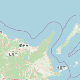
Map view of Akan Mashu National Park

Use this park location map to pinpoint Akan Mashu National Park in Japan, understand its exact geographic position, and read its mapped placement within the surrounding landscape more clearly.

Pigeon | © OpenStreetMap contributors

Location context for Akan Mashu National Park

Hokkaido
Park atlas

Compare volcanic landscapes, caldera lakes, and geothermal regions across Hokkaido's conservation areas.

Explore Nearby National Parks and Protected Areas around Akan Mashu National Park

Discover a curated selection of national parks and protected areas near Akan Mashu National Park, offering rich insights into Hokkaido's diverse volcanic terrain and unique conservation landscapes. Trace the geographic spread of Japan's protected regions, compare distinct caldera formations, and map the distribution of significant geothermal activity across the island.
Watercolor painting of a wetland landscape with reeds, trees, and distant hills
National parkHokkaido
About 49 km away#1 closest

South

Kushiro-Shitsugen National Park: Protected Wetland Ecosystems and Landscape

Explore the mapped terrain of eastern Hokkaido's vital peatlands.

Kushiro-Shitsugen National Park is a national park in eastern Hokkaido, Japan, safeguarding the nation's largest wetland and peatland. The park encompasses the expansive Kushiro Wetlands, characterized by vast reedbeds and a network of meandering rivers, making it a critical habitat for species like the endangered red-crowned crane. This protected area offers a unique landscape for understanding Japan's freshwater ecosystems and their geographic distribution within the region.

Area
268.61 km²
Established
1987
IUCN
II
Visitors
460K annual
National parkHokkaido
About 78 km away#2 closest

Northeast

Shiretoko National Park: Hokkaido's Protected Natural Landscape and Geography

Explore mapped boundaries and regional park context.

Shiretoko National Park, designated as a national park in Hokkaido, Japan, serves as a vital point for understanding regional geography and protected landscape exploration. This entry offers a structured view of the park's geographic scope, focusing on its mapped boundaries and natural terrain. Discover how Shiretoko National Park contributes to the broader atlas of conservation lands in the Hokkaido region, providing context for its unique ecological and geographic significance.

Area
386.36 km²
Established
1964
IUCN
II
Relief
Mountain
National parkJapan
About 85 km away#3 closest

West

Daisetsuzan National Park: Japan's Premier Volcanic Alpine Protected Landscape

Explore Hokkaido's largest national park and its vast mountain terrain.

Daisetsuzan National Park is a monumental protected area, covering extensive mountainous territory in Hokkaido, Japan. This national park is characterized by its dramatic volcanic geography, featuring numerous peaks over 2,000 meters and a rugged backcountry that defines Japan's northern alpine wilderness. Delve into the mapped boundaries and regional context of this significant protected landscape to understand its unique geological identity and ecological importance.

Area
2,267.64 km²
Established
1934
IUCN
II
Visitors
6M annual
Abstract watercolor painting with soft green and light blue hues on white background
National parkHokkaido
About 168 km away#4 closest

Southwest

Hidakasanmyaku-Erimo-Tokachi National Park: Japan's Largest Protected Landscape Atlas

Volcanic peaks, coastal cliffs, and Hokkaido's expansive geography.

Hidakasanmyaku-Erimo-Tokachi National Park represents Japan's largest national park, offering a comprehensive exploration of its protected landscape. This vast area in Hokkaido combines the rugged topography of the Hidaka volcanic mountain range with the striking maritime environment of Cape Erimo. Users can explore detailed geographic contexts, understand the park's extensive boundaries, and appreciate its role as a crucial protected natural area at the intersection of alpine and coastal ecosystems.

Area
2,456.68 km²
Established
2024
IUCN
II
Relief
Mountain
National parkHokkaido
About 284 km away#5 closest

West

Shikotsu-Tōya National Park: Hokkaido's Premier Volcanic National Park with Caldera Lakes

Explore mapped terrain, geothermal features, and active volcanoes.

Shikotsu-Tōya National Park, located in Hokkaido, Japan, is a prime example of a protected area defined by its intense volcanic geology. The park features prominent caldera lakes, including Lake Shikotsu and Lake Tōya, surrounded by active volcanic cones and dramatic geothermal landscapes. Its distinctive terrain makes it a key destination for understanding regional geography and the mapped protected areas of Japan's northern island, offering a unique glimpse into dynamic geological processes.

Area
994.73 km²
Established
1949
IUCN
II
Relief
Mountain
National parkHokkaido
About 303 km away#6 closest

Northwest

Rishiri-Rebun-Sarobetsu National Park: Volcanic Islands and Coastal Wetlands of Northern Hokkaido

Explore its mapped geography and unique subarctic alpine flora.

Rishiri-Rebun-Sarobetsu National Park in Hokkaido, Japan, offers a unique exploration of dramatic volcanic islands and vital coastal wetland ecosystems. This protected area showcases striking geological formations, from the conical peaks of Rishiri and Rebun islands to the vast peat bogs of the Sarobetsu Plain. Its subarctic environment supports a rich tapestry of alpine flora, providing a distinct case study in protected landscape geography and mapping for the region.

Area
241.66 km²
Established
1974
IUCN
II
Visitors
730K annual
National parkJapan
About 429 km away#7 closest

Southwest

Towada-Hachimantai National Park: Mapping Japan's Volcanic and Alpine Protected Landscapes

Explore the geography of this northern Honshu national park.

Towada-Hachimantai National Park offers a unique atlas perspective on Japan's dynamic volcanic geology and alpine ecosystems. This national park protects a vast expanse of rugged terrain, featuring the iconic caldera of Lake Towada and the expansive volcanic plateaus of the Hachimantai region. Understanding its mapped boundaries reveals the distribution of its characteristic landscapes, from old-growth beech forests along river valleys to subalpine environments crowning volcanic peaks, providing a deep dive into its protected natural geography.

Area
855.34 km²
Established
1936
IUCN
II
Visitors
5.9M annual
National parkTōhoku
About 475 km away#8 closest

Southwest

Sanriku Fukkō National Park: National Park Protected Landscape and Regional Geography

Explore mapped boundaries and natural terrain in Tōhoku.

Sanriku Fukkō National Park serves as a pivotal protected area within the Tōhoku region, offering rich geographic detail for atlas exploration. This national park's identity is intrinsically linked to its mapped landscape and protected boundaries, providing valuable insights into northeastern Japan's natural terrain. Through its representation, users gain a structured understanding of the park's place within the regional geography, facilitating a deeper dive into protected land contexts.

Area
285.37 km²
Established
2013
IUCN
II
Relief
Lowland

Common questions about visiting, size, designation, and location context for Akan Mashu National Park

Akan Mashu National Park FAQs for park facts, access, geography, and protected area context

Find quick answers about Akan Mashu National Park, including protected-area facts, park geography, trail and visitor context, and how the park fits into its surrounding country and regional landscape.
MoriAtlas Explorer

Continue Your Protected Areas Search Across the Global Atlas

Deepen your exploration by continuing the structured search for national parks and protected areas worldwide. Utilize the comprehensive filtering capabilities to compare different conservation landscapes and refine your understanding of global park geography. Discover more about the distribution and characteristics of protected natural areas.

Global natural geography