Mori Atlas logo
National parkSanriku Fukkō National Park

Discover the mapped boundaries and natural terrain of this vital Japanese national park.

Sanriku Fukkō National Park: Protected Landscape and Regional Geography in Tōhoku

(Sanriku Fukkō Kokuritsu Kōen)

Sanriku Fukkō National Park represents a significant protected landscape within the Tōhoku region of Japan. This national park offers a unique opportunity to explore its geographic scope, mapped terrain, and protected boundaries. As a key component of Japan's conservation network, it provides essential context for understanding regional natural landscapes and their atlas representation. Users can delve into the specific features and spatial distribution that define Sanriku Fukkō National Park within its broader geographic setting.

Coastal National ParksRia CoastlineSea CliffsSeabird ColoniesTōhoku RegionReconstruction Parks

Sanriku Fukkō National Park

National park

Park overview

Structured park overview, official facts, and landscape profile for Sanriku Fukkō National Park

Sanriku Fukkō National Park park facts, protected area profile, and essential visitor context
Review the core facts for Sanriku Fukkō National Park, including designation, size, terrain, visitor scale, habitats, and operating context in one park-focused overview.

About Sanriku Fukkō National Park

Sanriku Fukkō National Park represents one of Japan's newest national parks, established in 2013 as a direct response to the catastrophic 2011 Tōhoku earthquake and tsunami that devastated the Sanriku Coast. The park stretches approximately 180 kilometers along the Pacific coastline, encompassing portions of Aomori, Iwate, and Miyagi prefectures. This coastal region has long been recognized for its dramatic scenery, where the powerful Pacific Ocean has sculpted unique geological formations over millennia. The park's creation involved merging the former Rikuchū Kaigan National Park with adjacent prefectural natural parks, creating a more comprehensive protection framework for the coastline. The name "Fukkō" (復興) specifically denotes reconstruction or revival, making this park unique among Japan's protected areas as both a nature reserve and a testament to community resilience. The park continues to grow, with planned inclusions of additional prefectural natural parks that will further expand protection along this significant coastal ecosystem.

Quick facts and research context for Sanriku Fukkō National Park

Sanriku Fukkō National Park occupies 285.37 square kilometers along the Sanriku Coast in Japan's Tōhoku region, extending from Hachinohe in Aomori Prefecture south through Iwate Prefecture to Kesennuma in Miyagi Prefecture. The park was established on 24 May 2013 as a reconstruction project following the 2011 Tōhoku earthquake and tsunami, incorporating the former Rikuchū Kaigan National Park which had existed since 1955. The coastline displays two distinct geological characters: the northern section features an uplifted coastline with dramatic cliffs, while the southern portion exemplifies a ria coastline with deep inlets, narrow peninsulas, and sheltered bays. The park is managed by Japan's Ministry of the Environment and continues to expand through the incorporation of additional prefectural natural parks.

Park context

Deeper park guide and search-rich context for Sanriku Fukkō National Park

Sanriku Fukkō National Park history, landscape, wildlife, and travel context
Explore Sanriku Fukkō National Park through its history, landscape character, ecosystems, wildlife, conservation priorities, cultural context, and seasonal travel timing in a structured park guide built for atlas discovery and search intent.

Why Sanriku Fukkō National Park stands out

Sanriku Fukkō National Park is best known for its spectacular sea-eroded coastal landscapes, particularly the dramatic rock pillars and islands that define the Sanriku Coast. The northern portion features the impressive Kita Yamazaki cliffs, an 8-kilometer-long and 200-meter-high wall of rock nicknamed the "Alps of the Sea" for its mountainous appearance rising from the ocean. The park protects significant populations of black-tailed gulls that nest at locations like Kabushima, as well as shearwater colonies and occasional Japanese serow sightings in the higher terrain. The park's identity is inseparable from the 2011 disaster and subsequent recovery efforts, making it both a natural reserve and a symbol of regional reconstruction. Notable scenic locations include Jōdogahama, Goishi Coast, and Kinkasan island.

Sanriku Fukkō National Park history and protected-area timeline

The protected area history of Sanriku Fukkō National Park traces back to 2 May 1955 when Rikuchū Kaigan National Park was originally established in the Tōhoku region, extending 180 kilometers along the Pacific coastline from northern Miyagi Prefecture to northern Iwate Prefecture with an original area of 121.98 square kilometers. This earlier park protected the coastal landscapes that local communities had long valued for their scenic beauty and ecological significance. The transformation into Sanriku Fukkō National Park occurred on 24 May 2013, directly following the unprecedented devastation of the 2011 Tōhoku earthquake and tsunami, which struck the Sanriku Coast with catastrophic force. The park's redesignation reflected both the need to expand protection for the recovering coastline and to create a symbol of regional reconstruction. In March 2015, the Ministry of the Environment further expanded the park to include the former Minami Sanriku Kinkasan Quasi-National Park, and additional extensions are planned to incorporate several more prefectural natural parks including Kesennuma, Kenjōsan Mangokuura, and Matsushima Prefectural Natural Parks.

Sanriku Fukkō National Park landscape and geographic character

The landscape of Sanriku Fukkō National Park is defined by the dynamic interaction between the Pacific Ocean and the mountainous Japanese coastline, creating two distinct coastal characters within its boundaries. The northern section around Iwate Prefecture represents an uplifted coastline, where tectonic activity has raised marine terraces and steep cliffs above sea level. This area has experienced multiple powerful earthquakes and tsunami throughout history, with the 2011 disaster being the most recent of many events that have shaped both the terrain and the human communities along the coast. The southern portion around Miyagi Prefecture exemplifies a ria coastline, where submerged river valleys have created deep inlets, narrow peninsulas, and numerous small bays and coves. Throughout the park, sea erosion has produced remarkable geological features including rock pillars, isolated islands, and dramatic cliff faces. The most impressive feature is Kita Yamazaki in the northern park, an 8-kilometer-long wall of cliffs rising 200 meters from the ocean, often called the "Alps of the Sea" for its towering, mountain-like presence against the water.

Sanriku Fukkō National Park ecosystems, habitats, and plant life

The nature of Sanriku Fukkō National Park centers on its coastal ecosystems and the hardy vegetation that thrives along this exposed Pacific shoreline. The park's flora includes characteristic species adapted to maritime conditions, with groves of Japanese red pine (Pinus densiflora) providing backbone forest coverage on slopes and headlands. Rhododendrons bloom seasonally along the coastal cliffs, adding color to the rocky landscape, while Rosa rugosa occupies coastal margins and disturbed areas. The marine environment supports productive ecosystems where the cold Pacific currents bring nutrient-rich waters to the coast. The transition from northern uplifted coast to southern ria coast creates habitat diversity, with rocky shores, sandy beaches, tidal zones, and offshore islands each supporting different communities. The park's establishment as a reconstruction project following the 2011 disaster also reflects a commitment to ecological recovery alongside human recovery, recognizing that the health of the coastline's natural systems is integral to regional resilience.

Sanriku Fukkō National Park wildlife and species highlights

The wildlife of Sanriku Fukkō National Park is characterized by significant seabird populations that nest on the coastal cliffs and islands throughout the park. Black-tailed gulls represent one of the most notable species, with Kabushima serving as a particularly important large breeding ground where thousands of these birds gather seasonally. Shearwaters also nest in the park, utilizing burrows in coastal grasslands and slopes. These seabird colonies contribute to the ecological character of the coastline and attract attention from birdwatchers visiting the region. In terms of larger mammals, Japanese serow (kamoshika) have been sighted within the park, particularly in the more vegetated hilly areas away from the immediate coast. The marine environment supports various fish species and marine mammals that depend on the coastal waters, though specific cetacean populations are not extensively documented in the source material. The cliff ecosystems provide nesting habitat for raptors and other birds that prey on the abundant seabird colonies.

Sanriku Fukkō National Park conservation status and protection priorities

Sanriku Fukkō National Park holds significance beyond typical nature protection as a park created specifically to advance both ecological restoration and regional recovery following the 2011 Tōhoku disaster. The park's designation in 2013 represented a commitment to protecting the Sanriku Coast's natural assets as part of broader reconstruction efforts, integrating environmental conservation with community resilience. IUCN categorizes the park as Category II (National Park), reflecting its primary purpose of protecting outstanding natural landscapes and enabling sustainable recreation. The expansion in 2015 to include former Minami Sanriku Kinkasan Quasi-National Park demonstrated the ongoing commitment to strengthening protection along this coastline. The continued incorporation of additional prefectural natural parks into the national park system reflects a systematic approach to coastal conservation in the region. The park also includes designated Places of Scenic Beauty such as Jōdogahama, acknowledging the cultural and aesthetic value of the coastline alongside its ecological importance.

Sanriku Fukkō National Park cultural meaning and human context

The Sanriku Coast has a long human history intertwined with its dramatic landscape, where coastal communities have developed around fishing, maritime trade, and relationship with the sea. The 2011 Tōhoku earthquake and tsunami profoundly shaped the region's contemporary identity, with the park's "Fukkō" (reconstruction) designation directly referencing this recent history. The coastline features numerous locations of historical and cultural significance, including the famous Miracle ipponmatsu (Takata-matsubara) at Rikuzentakata, a pine tree that survived the tsunami and became a symbol of hope. The coastal geography with its ria coastline and natural harbors supported the development of fishing communities and port towns throughout the historical period. Religious and spiritual connections to the coastline are evident in places like Kinkasan island, which has been a site of pilgrimage. The landscape's nickname as the "Alps of the Sea" reflects how local communities have long perceived and valued these dramatic coastal formations.

Top sights and standout views in Sanriku Fukkō National Park

The highlights of Sanriku Fukkō National Park center on its exceptional coastal scenery and the story of regional recovery that defines its identity. The dramatic cliffs of Kita Yamazaki, rising 200 meters along an 8-kilometer stretch, represent the park's most impressive geological feature and embody the "Alps of the Sea" character. Jōdogahama in Iwate Prefecture is designated as a Place of Scenic Beauty, offering visitors access to the park's characteristic rock formations and coastal views. The seabird colonies at Kabushima provide remarkable wildlife observation opportunities, particularly during breeding season when thousands of black-tailed gulls congregate. Kinkasan island at the southern end of the park offers both scenic and spiritual significance. The Goishi Coast provides another notable scenic area within the park's Iwate portion. Perhaps most importantly, the park itself stands as a highlight—a symbol of reconstruction and resilience that visitors can experience while exploring a landscape of natural beauty and geological significance.

Best time to visit Sanriku Fukkō National Park

The best time to visit Sanriku Fukkō National Park depends on what visitors hope to experience, though the park's coastal location means it can be appreciated throughout the year with different seasonal characteristics. Spring brings rhododendron blooms to the coastal cliffs and represents a popular time for Japanese visitors to see the park's floral displays. Summer offers the warmest conditions for coastal exploration and beach activities at the park's sandy coves, though this period also coincides with peak visitor season. Autumn provides comfortable temperatures and potentially clearer skies, making it suitable for scenic coastal drives and hiking along the cliff-top trails. Winter, while colder, offers a different perspective on the dramatic coastline with potentially dramatic wave action and fewer crowds. Those interested in seabird viewing should note that breeding season for black-tailed gulls occurs in spring and early summer. The park's proximity to the Pacific means weather can change rapidly, and visitors should be prepared for conditions appropriate to the season.

Park location guide

Geography guide, regional context, and park location map for Sanriku Fukkō National Park

Sanriku Fukkō National Park park geography, regions, and map view in Japan
Understand where Sanriku Fukkō National Park sits in Japan through a broader geographic reading of the surrounding landscape, nearby location context, and its mapped position within the national park landscape.

How Sanriku Fukkō National Park fits into Japan

Japan is an island nation in East Asia comprising over 14,000 islands in the Pacific Ocean. The country operates as a unitary parliamentary constitutional monarchy with Emperor Naruhito as the reigning monarch and Prime Minister Sanae Takaichi leading the government. With a population of approximately 123 million, Japan is the world's 11th most populous country and a major economic power with one of the strongest militaries, though it has constitutionally renounced its right to declare war.

Wider geography shaping Sanriku Fukkō National Park in Japan

Japan is an island nation in the Pacific Ocean, bordered to the west by the Sea of Japan and extending from the Sea of Okhotsk in the north to the East China Sea in the south. The Japanese archipelago lies off the northeast coast of the Asian mainland. Approximately 75% of Japan's terrain is mountainous and heavily forested, with agricultural land and urbanized populations concentrated along the eastern coastal plains. The country is divided into 47 administrative prefectures and eight traditional regions.

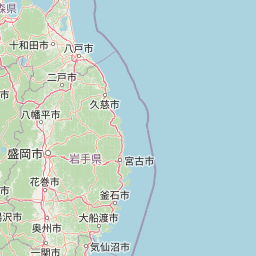
Map view of Sanriku Fukkō National Park

Use this park location map to pinpoint Sanriku Fukkō National Park in Japan, understand its exact geographic position, and read its mapped placement within the surrounding landscape more clearly.

Pigeon | © OpenStreetMap contributors

Location context for Sanriku Fukkō National Park

Aomori PrefectureIwate PrefectureMiyagi PrefectureTōhoku
Park atlas

Trace the Coastal Geography and Compare Other National Parks and Protected Landscapes Around Sanriku Fukkō National Park.

Discover More Protected Areas Near Sanriku Fukkō National Park in Japan's Tōhoku Region
Explore national parks and protected areas geographically connected to Sanriku Fukkō National Park, tracing the diverse coastal and inland landscapes of Japan's Tōhoku region. Compare unique geological features, ria coastlines, and conservation efforts, extending your atlas discovery beyond this prominent coastal reconstruction park.
National parkJapan

Towada-Hachimantai National Park: Mapping Japan's Volcanic and Alpine Protected Landscapes

Explore the geography of this northern Honshu national park.

Towada-Hachimantai National Park offers a unique atlas perspective on Japan's dynamic volcanic geology and alpine ecosystems. This national park protects a vast expanse of rugged terrain, featuring the iconic caldera of Lake Towada and the expansive volcanic plateaus of the Hachimantai region. Understanding its mapped boundaries reveals the distribution of its characteristic landscapes, from old-growth beech forests along river valleys to subalpine environments crowning volcanic peaks, providing a deep dive into its protected natural geography.

Area
855.34 km²
Established
1936
IUCN
II
Visitors
5.9M annual
National parkTōhoku region

Bandai-Asahi National Park: National Park Exploration and Geographic Context

Explore protected landscapes and mapped terrain in Japan's Tōhoku region.

Bandai-Asahi National Park provides critical insights into Japan's protected natural areas and regional geography. As a designated national park, it serves as a key entity for understanding mapped boundaries and landscape characteristics within the Tōhoku region. This page is designed for detailed atlas exploration, offering a focused view on the park's geography and its significance as a protected landscape.

Area
1,870.41 km²
Established
1950
IUCN
II
Visitors
7.1M annual
Abstract watercolor painting with soft green and light blue hues on white background
National parkHokkaido

Hidakasanmyaku-Erimo-Tokachi National Park: Japan's Largest Protected Landscape Atlas

Volcanic peaks, coastal cliffs, and Hokkaido's expansive geography.

Hidakasanmyaku-Erimo-Tokachi National Park represents Japan's largest national park, offering a comprehensive exploration of its protected landscape. This vast area in Hokkaido combines the rugged topography of the Hidaka volcanic mountain range with the striking maritime environment of Cape Erimo. Users can explore detailed geographic contexts, understand the park's extensive boundaries, and appreciate its role as a crucial protected natural area at the intersection of alpine and coastal ecosystems.

Area
2,456.68 km²
Established
2024
IUCN
II
Relief
Mountain
National parkHokkaido

Shikotsu-Tōya National Park: Hokkaido's Premier Volcanic National Park with Caldera Lakes

Explore mapped terrain, geothermal features, and active volcanoes.

Shikotsu-Tōya National Park, located in Hokkaido, Japan, is a prime example of a protected area defined by its intense volcanic geology. The park features prominent caldera lakes, including Lake Shikotsu and Lake Tōya, surrounded by active volcanic cones and dramatic geothermal landscapes. Its distinctive terrain makes it a key destination for understanding regional geography and the mapped protected areas of Japan's northern island, offering a unique glimpse into dynamic geological processes.

Area
994.73 km²
Established
1949
IUCN
II
Relief
Mountain
National parkTochigi Prefecture

Nikkō National Park: Discover its Protected Landscape and Regional Geography

Explore mapped boundaries and natural terrain within Tochigi Prefecture.

Understand Nikkō National Park as a key protected area within the geography of Tochigi Prefecture. This dedicated page provides an atlas-style overview of its natural landscape, mapped contours, and significance. Users can gain insights into the park's protected status and its placement within Japan's diverse natural regions, fostering a deeper appreciation for its geographic context.

Area
1,149.08 km²
Established
1934
IUCN
II
Relief
Mountain
National parkKantō region

Oze National Park National Park: A Key Protected Landscape in the Kantō Region

Explore its mapped geography and protected area context.

Oze National Park is a designated national park in Japan's Kantō region, offering a prime example of a protected landscape. This page provides detailed insights into its geographic setting and mapped boundaries, contributing to a structured understanding of regional natural terrain. Users can delve into the park's specific identity as a conservation area and its significance within the broader atlas of Japanese geography and protected lands.

Area
372.22 km²
Established
2007
IUCN
V
Relief
Mixed relief
Watercolor painting of a wetland landscape with reeds, trees, and distant hills
National parkHokkaido

Kushiro-Shitsugen National Park: Protected Wetland Ecosystems and Landscape

Explore the mapped terrain of eastern Hokkaido's vital peatlands.

Kushiro-Shitsugen National Park is a national park in eastern Hokkaido, Japan, safeguarding the nation's largest wetland and peatland. The park encompasses the expansive Kushiro Wetlands, characterized by vast reedbeds and a network of meandering rivers, making it a critical habitat for species like the endangered red-crowned crane. This protected area offers a unique landscape for understanding Japan's freshwater ecosystems and their geographic distribution within the region.

Area
268.61 km²
Established
1987
IUCN
II
Visitors
460K annual
National parkJapan

Jōshin'etsu-kōgen National Park: Protected Landscape and Regional Geography Atlas

Explore the mapped boundaries and geographic identity of this national park.

Jōshin'etsu-kōgen National Park represents a vital protected area within Japan, offering rich opportunities for geographic discovery through its mapped landscape. This entry provides detailed context on its protected boundaries and its relation to the surrounding regional geography, perfect for atlas-based exploration of natural terrains and conservation landscapes. Understand the unique geographic setting of this important national park.

Area
1,481.94 km²
Established
1949
IUCN
II
Relief
Mountain

Common questions about visiting, size, designation, and location context for Sanriku Fukkō National Park

Sanriku Fukkō National Park FAQs for park facts, access, geography, and protected area context
Find quick answers about Sanriku Fukkō National Park, including protected-area facts, park geography, trail and visitor context, and how the park fits into its surrounding country and regional landscape.
MoriAtlas Explorer

Continue Your Protected Areas Search Across the Global Atlas

Deepen your exploration by continuing the structured search for national parks and protected areas worldwide. Utilize the comprehensive filtering capabilities to compare different conservation landscapes and refine your understanding of global park geography. Discover more about the distribution and characteristics of protected natural areas.

Global natural geography