Mori Atlas logo
National parkNikkō National Park

Discover the mapped boundaries and natural terrain of this national park.

Nikkō National Park: Protected Landscape and Geographic Context in Tochigi Prefecture

Nikkō National Park stands as a vital protected landscape within Japan's Tochigi Prefecture, offering a unique lens for geographic discovery. This page provides essential context for understanding the park's mapped boundaries and its place within the broader regional geography. Engage with detailed information designed to illuminate the natural terrain and protected area identity of Nikkō National Park for atlas-driven exploration.

Volcanic landscapesAlpine wetlandsUNESCO World Heritage siteHistoric templesMountain lakesWaterfalls

Nikkō National Park

National park

Park overview

Structured park overview, official facts, and landscape profile for Nikkō National Park

Nikkō National Park park facts, protected area profile, and essential visitor context
Review the core facts for Nikkō National Park, including designation, size, terrain, visitor scale, habitats, and operating context in one park-focused overview.

About Nikkō National Park

Nikkō National Park occupies a striking position in the mountainous interior of central Honshū, where the volcanic landscapes of the Nikkō mountain range create a dramatic backdrop for one of Japan's most culturally significant protected areas. The park's terrain is characterized by steep ridgelines, deep valleys, alpine plateaus, and clear mountain streams that cascade through the landscape in numerous waterfalls. The volcanic origins of the region are evident in the presence of Mount Nikkō-Shirane, a shield volcano that contributes to the geological character of the area. Beyond its natural features, the park holds profound cultural importance as the site of Nikkō's renowned temple and shrine complex, which has drawn pilgrims and visitors for centuries. The seamless integration of spiritual architecture with the natural environment creates a landscape of exceptional harmony and beauty that defines the park's identity.

Quick facts and research context for Nikkō National Park

Nikkō National Park covers approximately 1,149 square kilometers across Tochigi, Gunma, and Fukushima prefectures in central Japan. The park features elevations ranging from around 400 meters to over 2,500 meters, creating diverse habitats across its alpine and subalpine zones. It was Japan's second national park to be established and remains one of the most visited, drawing millions of visitors annually to its temples, waterfalls, and mountain trails. The park is divided into three primary zones: Nikkō, Kinugawa/Kuriyama, and Nasu Kashi/Shiobara.

Park context

Deeper park guide and search-rich context for Nikkō National Park

Nikkō National Park history, landscape, wildlife, and travel context
Explore Nikkō National Park through its history, landscape character, ecosystems, wildlife, conservation priorities, cultural context, and seasonal travel timing in a structured park guide built for atlas discovery and search intent.

Why Nikkō National Park stands out

Nikkō National Park is best known for its extraordinary concentration of religious architecture set against a backdrop of volcanic mountain scenery. The park contains the UNESCO-designated Shrines and Temples of Nikkō, including the magnificent Nikkō Tōshō-gū shrine and Rinnō-ji temple complex. Its natural landmarks include Kegon Falls, one of Japan's three highest waterfalls at 97 meters, and the scenic Lake Chūzenji, a highland lake cradled beneath the imposing form of Mount Nantai. The park also encompasses the Ozegahara marshland, one of Japan's largest high-altitude wetlands, and prominent volcanic peaks including Mount Nantai and Mount Nikkō-Shirane.

Nikkō National Park history and protected-area timeline

The protection of Nikkō's landscapes began in the early 20th century when the Diet of Japan designated the area as an imperial park in 1911, recognizing its significance as both a natural and cultural treasure. The National Parks Law of 1931 provided the legal framework for establishing modern national parks in Japan, and Nikkō National Park was officially created on December 4, 1934, becoming one of the country's first national parks. Throughout the 20th century, the park's boundaries were expanded to encompass additional significant landscapes. In 2007, Oze National Park was separated from Nikkō National Park, becoming an independent protected area. The park's historical temples and shrines, particularly Nikkō Tōshō-gū and Rinnō-ji, were designated as a UNESCO World Heritage Site in 1999 as part of the Shrines and Temples of Nikkō.

Nikkō National Park landscape and geographic character

The landscape of Nikkō National Park is defined by its volcanic mountain terrain and the dramatic landforms created by ancient and ongoing geological activity. Mount Nantai rises to 2,486 meters above sea level, forming a prominent backdrop to Lake Chūzenji and creating one of the park's most iconic vistas. Mount Nikkō-Shirane reaches 2,578 meters and is classified as a shield volcano, reflecting the region's volcanic heritage. The park contains numerous wetlands and marshlands, most notably Ozegahara, a vast highland bog that represents one of Japan's most significant alpine wetland systems. Rivers and streams cut through the terrain, feeding the park's famous waterfalls including Kegon Falls at 97 meters and the twin Ryūzu Falls at 60 meters. The landscape transitions from broadleaf forest at lower elevations through coniferous forest to alpine zones at higher elevations.

Nikkō National Park ecosystems, habitats, and plant life

The ecological diversity of Nikkō National Park reflects its range of elevations and the variety of habitats found within its boundaries. The Ozegahara marshland is particularly notable, supporting the mizu-bashō, or white skunk cabbage, a distinctive plant species that blooms across the wetland during the summer months. The park's forests include magnificent stands of sugi, the Japanese cedar, which line many of the roads and trails around the Nikkō area. Maple trees and various fir species contribute to the forest composition, creating vibrant autumn color displays that draw visitors during the fall season. The highland wetlands support specialized plant communities adapted to acidic, waterlogged conditions, while the mountain streams and lakes provide habitat for aquatic species.

Nikkō National Park wildlife and species highlights

The diverse habitats within Nikkō National Park support a variety of wildlife species adapted to its forest, wetland, and alpine environments. The forested slopes provide shelter for numerous bird species and small mammals, while the wetlands and water bodies support amphibians and aquatic invertebrates. The park's elevation range creates opportunities for species adapted to different climatic zones, from those found in the broadleaf forests of the lower slopes to the more limited species that inhabit the subalpine and alpine zones. While the Wikipedia source emphasizes the park's botanical features and scenic landscapes, the protected status and habitat diversity suggest the presence of various wildlife suited to these mountain and wetland environments.

Nikkō National Park conservation status and protection priorities

Nikkō National Park represents one of Japan's earliest and most significant conservation achievements, established to protect both the region's outstanding natural landscapes and its cultural heritage. The park's designation as IUCN Category II reflects its primary goal of protecting natural ecosystems while allowing for sustainable recreation and environmental education. The inclusion of the Shrines and Temples of Nikkō within the park's boundaries reflects Japan's integrated approach to preserving the relationship between natural and cultural landscapes. The long history of protection, dating to the 1911 imperial park designation, has helped maintain the ecological integrity of the park's forests, wetlands, and mountain environments.

Nikkō National Park cultural meaning and human context

The cultural significance of Nikkō National Park is inseparable from its natural landscapes, as the area has been a center of religious practice and pilgrimage for centuries. Nikkō Tōshō-gū, a Shinto shrine dedicated to Tokugawa Ieyasu, is one of Japan's most important and visually striking religious structures, renowned for its elaborate architectural details and the famous Three Wise Monkey carvings. Rinnō-ji, a Buddhist temple complex, houses significant religious artifacts and maintains the spiritual traditions of the region. The park also contains the Sessho-seki, or killing stone, a historically significant site associated with Japanese folklore. These cultural elements have shaped the landscape for generations, and their preservation within the national park framework ensures that the spiritual and historical character of the region remains protected alongside its natural environments.

Top sights and standout views in Nikkō National Park

Nikkō National Park offers visitors a remarkable concentration of natural and cultural attractions within a single protected area. The Kegon Falls and Lake Chūzenji area represents one of the park's most spectacular natural scenes, where water plunges dramatically from volcanic cliffs into a serene mountain lake. The UNESCO World Heritage Site of Nikkō Tōshō-gū and Rinnō-ji provides access to some of Japan's finest religious architecture, with intricate woodwork and peaceful temple grounds. The highland trails of Ozegahara offer wetland exploration through one of Japan's largest alpine bogs, while the summit climbs of Mount Nantai and Mount Nikkō-Shirane provide access to panoramic mountain vistas. The park's network of onsen hot spring resorts allows visitors to experience traditional Japanese bathing culture while enjoying the mountain setting.

Best time to visit Nikkō National Park

The best time to visit Nikkō National Park depends on the experiences visitors seek, with each season offering distinct character. Spring brings blooming rhododendrons and mild temperatures ideal for hiking the park's numerous trails. Summer offers the fullest display of wetland flowers including the white skunk cabbage in Ozegahara, though this is also the peak tourist season. Autumn transforms the park's maple and deciduous forests into vivid displays of red and gold, creating particularly spectacular scenery around the temple areas and along mountain trails. Winter brings snow-covered landscapes and excellent conditions for skiing at the park's ski facilities, though some higher-elevation trails may be closed. The moderate climate of the lower elevations makes the park accessible for much of the year, while the temple and shrine complex can be appreciated in any season.

Park location guide

Geography guide, regional context, and park location map for Nikkō National Park

Nikkō National Park park geography, regions, and map view in Japan
Understand where Nikkō National Park sits in Japan through a broader geographic reading of the surrounding landscape, nearby location context, and its mapped position within the national park landscape.

How Nikkō National Park fits into Japan

Japan is an island nation in East Asia comprising over 14,000 islands in the Pacific Ocean. The country operates as a unitary parliamentary constitutional monarchy with Emperor Naruhito as the reigning monarch and Prime Minister Sanae Takaichi leading the government. With a population of approximately 123 million, Japan is the world's 11th most populous country and a major economic power with one of the strongest militaries, though it has constitutionally renounced its right to declare war.

Wider geography shaping Nikkō National Park in Japan

Japan is an island nation in the Pacific Ocean, bordered to the west by the Sea of Japan and extending from the Sea of Okhotsk in the north to the East China Sea in the south. The Japanese archipelago lies off the northeast coast of the Asian mainland. Approximately 75% of Japan's terrain is mountainous and heavily forested, with agricultural land and urbanized populations concentrated along the eastern coastal plains. The country is divided into 47 administrative prefectures and eight traditional regions.

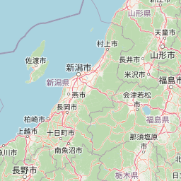
Map view of Nikkō National Park

Use this park location map to pinpoint Nikkō National Park in Japan, understand its exact geographic position, and read its mapped placement within the surrounding landscape more clearly.

Pigeon | © OpenStreetMap contributors

Location context for Nikkō National Park

Fukushima PrefectureGunma PrefectureTochigi Prefecture
Park atlas

Compare protected landscapes and trace adjacent national parks across the Kantō region's diverse volcanic terrain.

Explore National Parks Near Nikkō: Discover More Protected Areas in Japan's Kantō Region
Continue your exploration from Nikkō National Park by browsing other protected areas and national parks situated across Japan's volcanic mountain regions and highland landscapes. Compare varied terrain, discover more UNESCO World Heritage sites, and understand the regional spread of conservation efforts through a structured atlas view of nearby park geography.
National parkKantō region

Oze National Park National Park: A Key Protected Landscape in the Kantō Region

Explore its mapped geography and protected area context.

Oze National Park is a designated national park in Japan's Kantō region, offering a prime example of a protected landscape. This page provides detailed insights into its geographic setting and mapped boundaries, contributing to a structured understanding of regional natural terrain. Users can delve into the park's specific identity as a conservation area and its significance within the broader atlas of Japanese geography and protected lands.

Area
372.22 km²
Established
2007
IUCN
V
Relief
Mixed relief
National parkJapan

Jōshin'etsu-kōgen National Park: Protected Landscape and Regional Geography Atlas

Explore the mapped boundaries and geographic identity of this national park.

Jōshin'etsu-kōgen National Park represents a vital protected area within Japan, offering rich opportunities for geographic discovery through its mapped landscape. This entry provides detailed context on its protected boundaries and its relation to the surrounding regional geography, perfect for atlas-based exploration of natural terrains and conservation landscapes. Understand the unique geographic setting of this important national park.

Area
1,481.94 km²
Established
1949
IUCN
II
Relief
Mountain
National parkTōhoku region

Bandai-Asahi National Park: National Park Exploration and Geographic Context

Explore protected landscapes and mapped terrain in Japan's Tōhoku region.

Bandai-Asahi National Park provides critical insights into Japan's protected natural areas and regional geography. As a designated national park, it serves as a key entity for understanding mapped boundaries and landscape characteristics within the Tōhoku region. This page is designed for detailed atlas exploration, offering a focused view on the park's geography and its significance as a protected landscape.

Area
1,870.41 km²
Established
1950
IUCN
II
Visitors
7.1M annual
National parkJapan

Myōkō-Togakushi Renzan National Park: Mapped Protected Landscape Geography in Japan

Explore the park's regional terrain and protected area context.

Delve into the geographic specificities of Myōkō-Togakushi Renzan National Park, a key protected landscape in Japan. This entry focuses on its mapped terrain, regional setting, and the atlas-value of understanding its protected boundaries. Gain clarity on the park's distinct natural geography and its contribution to the broader protected area network.

Area
397.72 km²
Established
2015
IUCN
II
Relief
Mountain
National parkSaitama Prefecture

Chichibu-Tama-Kai National Park: Mapped Protected Landscape and Regional Geography

Explore the geographic identity of this national park.

Discover Chichibu-Tama-Kai National Park through its protected landscape features and geographic setting. This page provides detailed atlas context, focusing on the park's mapped boundaries and its contribution to the regional geography of Saitama Prefecture. Understand the unique character and structural significance of this national park for comprehensive geographic discovery.

Area
1,216 km²
Established
1950
IUCN
II
Relief
Mountain
Watercolor painting of green and pink mountain ranges with forested foreground and distant peaks.
National parkChūbu region

Minami Alps National Park: A Protected Alpine Wilderness in Japan's Chūbu Region

Discover its dramatic peaks and vital river headwaters.

Minami Alps National Park offers a profound exploration into Japan's high-altitude natural geography. As a national park, it preserves a dramatic alpine environment defined by glacially carved terrain and multiple peaks exceeding 3000 meters. This protected landscape serves as a vital watershed, safeguarding the origins of major river systems and showcasing a rugged mountain character distinct from more accessible areas, ideal for understanding protected wildlands.

Area
357.52 km²
Established
1964
IUCN
II
Relief
Mountain
Watercolor illustration of a mountain landscape with a lake, grasses, and flowers
National parkIshikawa Prefecture

Hakusan National Park: Sacred Mountain Protected Landscape in Ishikawa Prefecture

Mapped alpine terrain and volcanic geography for protected area discovery.

Hakusan National Park offers a unique exploration of Japan's sacred mountain heritage and alpine natural beauty. This protected landscape, centered on Mount Haku, features distinct volcanic terrain, crater lakes, and exceptional alpine flora. Users can explore the park's mapped boundaries, understand its place within Ishikawa Prefecture's geography, and appreciate its role as a significant UNESCO Biosphere Reserve for detailed atlas-based discovery.

Area
477 km²
Established
1962
IUCN
II
Relief
Mountain
National parkJapan

Fuji-Hakone-Izu National Park: Japan's Premier National Park with Diverse Volcanic Landscapes and Mapped Geography

Explore volcanic terrain, hot springs, islands, and Mount Fuji's iconic protected boundaries.

Fuji-Hakone-Izu National Park is a vast and diverse protected area in Japan, anchored by the iconic Mount Fuji. This national park features a remarkable range of volcanic landscapes, including natural hot springs, rugged coastlines, and the unique Izu Islands extending into the Pacific. Delve into its mapped geography and protected landscape identity for a comprehensive atlas-style understanding of this significant natural asset within Japan.

Area
1,227 km²
Established
1936
IUCN
II
Visitors
11.3M annual

Common questions about visiting, size, designation, and location context for Nikkō National Park

Nikkō National Park FAQs for park facts, access, geography, and protected area context
Find quick answers about Nikkō National Park, including protected-area facts, park geography, trail and visitor context, and how the park fits into its surrounding country and regional landscape.
MoriAtlas Explorer

Continue Your Protected Areas Search Across the Global Atlas

Deepen your exploration by continuing the structured search for national parks and protected areas worldwide. Utilize the comprehensive filtering capabilities to compare different conservation landscapes and refine your understanding of global park geography. Discover more about the distribution and characteristics of protected natural areas.

Global natural geography
Nikkō National Park: Protected Area, Map & Geography | MoriAtlas