Mori Atlas logo
National parkJōshin'etsu-kōgen National Park

Discover the mapped boundaries and regional geography of this significant national park in Japan.

Jōshin'etsu-kōgen National Park: Japan's Protected Landscape Atlas and Geographic Context

(上信越高原国立公園)

Jōshin'etsu-kōgen National Park stands as a key protected area within Japan's diverse geography. This dedicated page offers an atlas-centric view, detailing the park's mapped boundaries and its place within the broader natural landscape context of the Japanese archipelago. Understand the geographic identity of this national park for structured exploration and informed landscape discovery.

volcanic landscapesalpine environmentshot springsski resortsmountain climbingactive volcanoes

Jōshin'etsu-kōgen National Park

National park

Park overview

Structured park overview, official facts, and landscape profile for Jōshin'etsu-kōgen National Park

Jōshin'etsu-kōgen National Park park facts, protected area profile, and essential visitor context
Review the core facts for Jōshin'etsu-kōgen National Park, including designation, size, terrain, visitor scale, habitats, and operating context in one park-focused overview.

About Jōshin'etsu-kōgen National Park

Jōshin'etsu-kōgen National Park occupies a significant position in Japan's protected area network as a landscape of exceptional geological, ecological, and recreational importance. The park's territory spans the mountainous border regions where the former provinces of Kōzuke (now Gunma), Shinano (now Nagano), and Echigo (now Niigata) converge, creating a zone of remarkable topographical diversity. This volcanic highland region features a succession of peaks, caldera basins, plateaus, and valleys that have been shaped by millions of years of volcanic activity and subsequent erosional processes. The park encompasses both active and dormant volcanic systems that continue to influence the landscape through thermal activity, soil composition, and the creation of unique hydrothermal environments. Beyond its volcanic character, the park protects extensive areas of subalpine forest, alpine meadows, and wetland habitats that support rich biodiversity. The human history of this region is equally significant, with the area long serving as a destination for mountain worship, hot spring bathing, and more recently, alpine sports development.

Quick facts and research context for Jōshin'etsu-kōgen National Park

Jōshin'etsu-kōgen National Park covers 148,194 hectares across three prefectures in central Japan. The park was established on September 7, 1949 and holds IUCN Category II protection status. It encompasses multiple volcanic peaks including Mount Asama at 2,542 meters, Mount Kusatsu-Shirane at 2,162 meters, and Mount Tanigawa at 1,963 meters. The park is managed by Japan's Ministry of the Environment and features two main recreational areas: the Southern Niigata/North Nagano Area and the East Nagano Area. A portion of the original park was separated in 2015 to become Myōkō-Togakushi Renzan National Park.

Park context

Deeper park guide and search-rich context for Jōshin'etsu-kōgen National Park

Jōshin'etsu-kōgen National Park history, landscape, wildlife, and travel context
Explore Jōshin'etsu-kōgen National Park through its history, landscape character, ecosystems, wildlife, conservation priorities, cultural context, and seasonal travel timing in a structured park guide built for atlas discovery and search intent.

Why Jōshin'etsu-kōgen National Park stands out

Jōshin'etsu-kōgen National Park is best known for its dramatic volcanic landscape and its concentration of significant peaks along the border of Nagano and Gunma prefectures. Mount Asama, the most active volcano on Japan's main island, dominates the southern section and provides ongoing geological interest. The park is also renowned for its extensive ski resorts, particularly in the Shiga Kōgen area, which forms part of one of Japan's premier winter sports destinations. The combination of volcanic terrain, alpine lakes, hot springs, and world-class skiing makes this park distinctive among Japan's national parks, offering both natural scientific interest and exceptional recreational opportunities in every season.

Jōshin'etsu-kōgen National Park history and protected-area timeline

Jōshin'etsu-kōgen National Park was established on September 7, 1949, representing an early addition to Japan's post-war national park system. The initial park designation protected a substantial area of volcanic highland terrain, but the boundaries were significantly expanded in 1956 to incorporate the Myōkō-Togakushi mountainous region, greatly increasing the park's ecological and topographical diversity. This expansion reflected growing recognition of the importance of protecting complete mountain ecosystems and the recreational value of the region. In a significant boundary adjustment that took effect on March 27, 2015, the Myōkō-Togakushi area was separated from Jōshin'etsu-kōgen to become its own national park, designated as Myōkō-Togakushi Renzan National Park, with an area of approximately 39,772 hectares. This separation allowed for more focused management of the distinct Myōkō-Togakushi mountain group while leaving the core Jōshin'etsu-kōgen area to be managed according to its specific character and challenges.

Jōshin'etsu-kōgen National Park landscape and geographic character

The landscape of Jōshin'etsu-kōgen National Park is fundamentally defined by its volcanic origins and ongoing geological activity. The park encompasses portions of several significant mountain ranges and volcanic complexes that rise dramatically from the surrounding lowlands. Mount Asama, standing at 2,542 meters, is the most prominent peak and remains the most active volcano on Honshū, with recorded eruptions and ongoing thermal activity that continually reshapes its immediate environment. Mount Kusatsu-Shirane reaches 2,162 meters and features distinctive volcanic terrain including crater lakes and acidic hot springs. Mount Tanigawa, at 1,963 meters, forms a dramatic northern boundary and is known for its steep, rugged character. Between these major peaks, the park contains numerous smaller volcanic formations, debris-covered slopes, and the elevated plateaus that give the park its name. The terrain varies from steep alpine ridges to more gentle highland basins, with elevation changes creating significant ecological zonation throughout the park.

Jōshin'etsu-kōgen National Park ecosystems, habitats, and plant life

The ecological character of Jōshin'etsu-kōgen reflects the interaction between volcanic soils, elevation gradients, and the climate patterns of central Japan. The park supports a sequence of vegetation zones as elevation increases, transitioning from mixed forest at lower elevations through subalpine coniferous forest to alpine meadows and exposed rock at the highest peaks. The volcanic geology creates distinctive habitat conditions, with areas of recent volcanic activity supporting early colonizing vegetation while older volcanic deposits support more developed forest communities. The combination of significant elevation range, varied terrain, and the presence of volcanic wetlands creates a mosaic of habitats that supports considerable biodiversity. Alpine meadows and krummholz zones at higher elevations provide important habitat for specialized species, while the forest zones support typical Japanese montane fauna. The numerous streams and wetlands associated with volcanic terrain add further ecological diversity to the park's character.

Jōshin'etsu-kōgen National Park wildlife and species highlights

The wildlife of Jōshin'etsu-kōgen reflects the park's position in central Japan's montane environments, with species adapted to both forest and alpine habitats. The subalpine and montane forests support populations of Japanese serow and Japanese macaques, the latter being particularly notable in areas where they have become accustomed to human presence around tourist facilities. Bird species include various thrushes, warblers, and raptors that use the diverse habitats throughout the park. The alpine zones above treeline provide habitat for species specifically adapted to harsh conditions, while the numerous streams and wetlands support aquatic species and water-associated bird life. The park's elevation range and variety of habitats create conditions suitable for a range of mammalian, avian, and smaller fauna species, though detailed species inventories are not prominently featured in available source materials.

Jōshin'etsu-kōgen National Park conservation status and protection priorities

Jōshin'etsu-kōgen National Park holds IUCN Category II protected area status, reflecting its designation as a national park focused on ecosystem protection and public recreation. The park's conservation significance stems from its protection of representative volcanic highland ecosystems in central Japan, its collection of significant volcanic peaks including an active volcano, and the diverse habitats that occur across its elevation range. The park also protects important watershed areas that feed rivers serving surrounding agricultural and populated regions. Management by Japan's Ministry of the Environment focuses on balancing conservation objectives with sustainable recreation, particularly given the intensive use of certain areas for skiing and other outdoor activities. The separation of the Myōkō-Togakushi area in 2015 reflected evolving understanding of optimal conservation boundaries for different mountain ecosystems.

Jōshin'etsu-kōgen National Park cultural meaning and human context

The region encompassed by Jōshin'etsu-kōgen National Park has a long human history connected to its mountain landscapes and volcanic features. The area's hot springs have drawn visitors for centuries, with onsen culture deeply embedded in the regional identity. The mountains themselves have been sites of religious significance, with traditions of mountain worship contributing to the spiritual landscape of the region. The development of ski resorts and mountain tourism began in the early twentieth century and accelerated significantly after World War II, transforming parts of the park into major recreational destinations while creating ongoing discussions about the balance between development and conservation. Communities like Yamanouchi, with its hot springs including the famous Jōshin'etsu-kōgen snow monkey park, and the resort town of Karuizawa represent the intersection of traditional hot spring culture with modern alpine tourism.

Top sights and standout views in Jōshin'etsu-kōgen National Park

The volcanic peaks of Jōshin'etsu-kōgen form the park's most dramatic landscape features, with Mount Asama's ongoing activity providing ongoing geological interest and Mount Kusatsu-Shirane's crater lakes offering striking scenery. The extensive ski resort infrastructure of Shiga Kōgen represents one of Japan's premier winter sports destinations, with well-developed facilities and extensive terrain. The park's hot springs, particularly those accessible from Yudanaka and the broader Yamanouchi area, provide year-round attraction and connect to long traditions of thermal bathing. The Shiga-Kusatsu-Kogen Ridge Highway traverses the park, providing access to both the alpine zones and the hot spring resorts. The combination of active volcanic landscapes, excellent skiing, quality hot springs, and mountain climbing opportunities makes this park particularly distinctive in Japan's national park system.

Best time to visit Jōshin'etsu-kōgen National Park

Jōshin'etsu-kōgen National Park offers distinct attractions across seasons, each bringing different conditions and experiences. Winter transforms the park into a major ski destination, with the extensive facilities of Shiga Kōgen and surrounding areas operating from approximately December through March, offering reliable snow conditions in what is one of Japan's most reliable winter sports regions. Summer brings excellent hiking conditions on the mountain trails, with the alpine zones offering escape from lowland heat and the opportunity to explore the volcanic landscapes at a comfortable pace. The shoulder seasons of spring and autumn offer their own attractions, with spring bringing the melting of snowpacks and new growth in the meadows, while autumn displays the characteristic colors of Japanese deciduous forests. The hot springs provide year-round appeal, making any season viable for visiting the onsen areas. The active nature of Mount Asama means that volcanic activity conditions may affect access to certain areas at times, with park management providing guidance on current conditions.
Park location guide

Geography guide, regional context, and park location map for Jōshin'etsu-kōgen National Park

Jōshin'etsu-kōgen National Park park geography, regions, and map view in Japan
Understand where Jōshin'etsu-kōgen National Park sits in Japan through a broader geographic reading of the surrounding landscape, nearby location context, and its mapped position within the national park landscape.

How Jōshin'etsu-kōgen National Park fits into Japan

Japan is an island nation in East Asia comprising over 14,000 islands in the Pacific Ocean. The country operates as a unitary parliamentary constitutional monarchy with Emperor Naruhito as the reigning monarch and Prime Minister Sanae Takaichi leading the government. With a population of approximately 123 million, Japan is the world's 11th most populous country and a major economic power with one of the strongest militaries, though it has constitutionally renounced its right to declare war.

Wider geography shaping Jōshin'etsu-kōgen National Park in Japan

Japan is an island nation in the Pacific Ocean, bordered to the west by the Sea of Japan and extending from the Sea of Okhotsk in the north to the East China Sea in the south. The Japanese archipelago lies off the northeast coast of the Asian mainland. Approximately 75% of Japan's terrain is mountainous and heavily forested, with agricultural land and urbanized populations concentrated along the eastern coastal plains. The country is divided into 47 administrative prefectures and eight traditional regions.

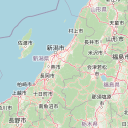
Map view of Jōshin'etsu-kōgen National Park

Use this park location map to pinpoint Jōshin'etsu-kōgen National Park in Japan, understand its exact geographic position, and read its mapped placement within the surrounding landscape more clearly.

Pigeon | © OpenStreetMap contributors

Location context for Jōshin'etsu-kōgen National Park

Chūbu regionGunma PrefectureNagano PrefectureNiigata Prefecture
Park atlas

Browse Surrounding Volcanic Highlands, Alpine Environments, and Central Honshū Protected Landscapes

Discover Other National Parks and Protected Areas Near Jōshin'etsu-kōgen National Park
After exploring Jōshin'etsu-kōgen National Park's volcanic peaks and alpine zones, continue your discovery by mapping other national parks and protected areas across Japan's Chūbu region. Compare adjacent protected landscapes, identify shared volcanic features, and trace the regional spread of conserved natural environments from a geographic perspective.
National parkJapan

Myōkō-Togakushi Renzan National Park: Mapped Protected Landscape Geography in Japan

Explore the park's regional terrain and protected area context.

Delve into the geographic specificities of Myōkō-Togakushi Renzan National Park, a key protected landscape in Japan. This entry focuses on its mapped terrain, regional setting, and the atlas-value of understanding its protected boundaries. Gain clarity on the park's distinct natural geography and its contribution to the broader protected area network.

Area
397.72 km²
Established
2015
IUCN
II
Relief
Mountain
National parkKantō region

Oze National Park National Park: A Key Protected Landscape in the Kantō Region

Explore its mapped geography and protected area context.

Oze National Park is a designated national park in Japan's Kantō region, offering a prime example of a protected landscape. This page provides detailed insights into its geographic setting and mapped boundaries, contributing to a structured understanding of regional natural terrain. Users can delve into the park's specific identity as a conservation area and its significance within the broader atlas of Japanese geography and protected lands.

Area
372.22 km²
Established
2007
IUCN
V
Relief
Mixed relief
National parkTochigi Prefecture

Nikkō National Park: Discover its Protected Landscape and Regional Geography

Explore mapped boundaries and natural terrain within Tochigi Prefecture.

Understand Nikkō National Park as a key protected area within the geography of Tochigi Prefecture. This dedicated page provides an atlas-style overview of its natural landscape, mapped contours, and significance. Users can gain insights into the park's protected status and its placement within Japan's diverse natural regions, fostering a deeper appreciation for its geographic context.

Area
1,149.08 km²
Established
1934
IUCN
II
Relief
Mountain
National parkSaitama Prefecture

Chichibu-Tama-Kai National Park: Mapped Protected Landscape and Regional Geography

Explore the geographic identity of this national park.

Discover Chichibu-Tama-Kai National Park through its protected landscape features and geographic setting. This page provides detailed atlas context, focusing on the park's mapped boundaries and its contribution to the regional geography of Saitama Prefecture. Understand the unique character and structural significance of this national park for comprehensive geographic discovery.

Area
1,216 km²
Established
1950
IUCN
II
Relief
Mountain
Watercolor painting of green and pink mountain ranges with forested foreground and distant peaks.
National parkChūbu region

Minami Alps National Park: A Protected Alpine Wilderness in Japan's Chūbu Region

Discover its dramatic peaks and vital river headwaters.

Minami Alps National Park offers a profound exploration into Japan's high-altitude natural geography. As a national park, it preserves a dramatic alpine environment defined by glacially carved terrain and multiple peaks exceeding 3000 meters. This protected landscape serves as a vital watershed, safeguarding the origins of major river systems and showcasing a rugged mountain character distinct from more accessible areas, ideal for understanding protected wildlands.

Area
357.52 km²
Established
1964
IUCN
II
Relief
Mountain
National parkTōhoku region

Bandai-Asahi National Park: National Park Exploration and Geographic Context

Explore protected landscapes and mapped terrain in Japan's Tōhoku region.

Bandai-Asahi National Park provides critical insights into Japan's protected natural areas and regional geography. As a designated national park, it serves as a key entity for understanding mapped boundaries and landscape characteristics within the Tōhoku region. This page is designed for detailed atlas exploration, offering a focused view on the park's geography and its significance as a protected landscape.

Area
1,870.41 km²
Established
1950
IUCN
II
Visitors
7.1M annual
Watercolor illustration of a mountain landscape with a lake, grasses, and flowers
National parkIshikawa Prefecture

Hakusan National Park: Sacred Mountain Protected Landscape in Ishikawa Prefecture

Mapped alpine terrain and volcanic geography for protected area discovery.

Hakusan National Park offers a unique exploration of Japan's sacred mountain heritage and alpine natural beauty. This protected landscape, centered on Mount Haku, features distinct volcanic terrain, crater lakes, and exceptional alpine flora. Users can explore the park's mapped boundaries, understand its place within Ishikawa Prefecture's geography, and appreciate its role as a significant UNESCO Biosphere Reserve for detailed atlas-based discovery.

Area
477 km²
Established
1962
IUCN
II
Relief
Mountain
National parkJapan

Fuji-Hakone-Izu National Park: Japan's Premier National Park with Diverse Volcanic Landscapes and Mapped Geography

Explore volcanic terrain, hot springs, islands, and Mount Fuji's iconic protected boundaries.

Fuji-Hakone-Izu National Park is a vast and diverse protected area in Japan, anchored by the iconic Mount Fuji. This national park features a remarkable range of volcanic landscapes, including natural hot springs, rugged coastlines, and the unique Izu Islands extending into the Pacific. Delve into its mapped geography and protected landscape identity for a comprehensive atlas-style understanding of this significant natural asset within Japan.

Area
1,227 km²
Established
1936
IUCN
II
Visitors
11.3M annual

Common questions about visiting, size, designation, and location context for Jōshin'etsu-kōgen National Park

Jōshin'etsu-kōgen National Park FAQs for park facts, access, geography, and protected area context
Find quick answers about Jōshin'etsu-kōgen National Park, including protected-area facts, park geography, trail and visitor context, and how the park fits into its surrounding country and regional landscape.
MoriAtlas Explorer

Continue Your Protected Areas Search Across the Global Atlas

Deepen your exploration by continuing the structured search for national parks and protected areas worldwide. Utilize the comprehensive filtering capabilities to compare different conservation landscapes and refine your understanding of global park geography. Discover more about the distribution and characteristics of protected natural areas.

Global natural geography