
Mori Atlas logo
Protected areaAmanda Bay

Mapping the stable fast ice and glacial terrain of this significant Antarctic inlet

Amanda Bay Protected Area and Coastal Geography in Remote East Antarctica Landscapes

Amanda Bay represents a distinct, ice-dominated coastal inlet along the Ingrid Christensen Coast of East Antarctica. This protected area features a unique combination of stable sea ice, the imposing cliffs of the Hovde Glacier, and the prominent Flatnes Ice Tongue. By examining the mapped boundaries and surrounding offshore islands such as Cowell Island and Hovde Island, you can better understand the interplay between grounded and floating ice formations within this remote polar environment.

antarcticaemperor penguinsseabird breeding colonyfast icesea iceglacial coast

Amanda Bay

Protected area

Park overview

Structured park overview, official facts, and landscape profile for Amanda Bay

Amanda Bay park facts, protected area profile, and essential visitor context

Review the core facts for Amanda Bay, including designation, size, terrain, visitor scale, habitats, and operating context in one park-focused overview.

About Amanda Bay

Amanda Bay is a small but ecologically significant inlet carved into the Ingrid Christensen Coast of Princess Elizabeth Land in East Antarctica. Positioned at the southern end of the broader Prydz Bay system, the bay sits between the Vestfold Hills, roughly 75 km to the north-east, and the Larsemann Hills, about 22 km to the south-west. Measuring roughly 6 km in length and 3 km in width, the bay opens north-westward into Prydz Bay and is surrounded almost entirely by glacial and sea-ice features rather than exposed rock.

The bay's northern and eastern shorelines are defined by the cliffs of the Hovde Glacier, with Hovde Island lying offshore to the north-east. To the south-west, the Flatnes Ice Tongue extends out into Prydz Bay, terminating near Cowell Island at the western corner of the inlet. Small islets lie within the bay itself, and a scattering of unnamed islands sits a few kilometres offshore. Because Amanda Bay is typically filled with fast ice, even during the Antarctic summer, it presents a stable, icebound surface that becomes ideal for species requiring solid platforms for breeding.

The single most important feature of Amanda Bay is its emperor penguin colony at the south-west corner, where several thousand pairs breed each year on the sea ice. This colony places the bay among the key emperor penguin breeding localities in East Antarctica. The combination of reliable fast ice, access to open water for foraging, and relative isolation from direct human disturbance has made the site attractive to penguins and significant to international conservation efforts.

Although it is not a conventional terrestrial national park, Amanda Bay functions as a protected natural area of the highest order. It is designated as Antarctic Specially Protected Area No. 169 under the Antarctic Treaty System, and it has also been recognized as an Important Bird Area by BirdLife International. Both designations reflect the bay's role as a habitat for one of the most iconic and vulnerable seabird species in the Southern Ocean and the wider importance of its coastal Antarctic ecosystem.

Quick facts and research context for Amanda Bay

Amanda Bay is a small coastal inlet on the Ingrid Christensen Coast of Princess Elizabeth Land, in East Antarctica. It opens north-westward into Prydz Bay and lies between the Vestfold Hills and the Larsemann Hills, roughly 22 km from the latter.

The bay is approximately 6 km long and 3 km wide, and is bounded by ice features including the Flatnes Ice Tongue, Cowell Island, the Hovde Glacier, and Hovde Island. Fast ice generally fills the bay throughout the year, including the summer season.

The site is formally designated as Antarctic Specially Protected Area No. 169 under the Antarctic Treaty System and has been recognized as an Important Bird Area by BirdLife International, both because of its emperor penguin colony.

Protection and recognition

Examine the documented conservation scope and status metrics for Amanda Bay.

Amanda Bay Protection Status and International Recognition Overview

Amanda Bay maintains a mixed protection scope within its regional conservation framework, incorporating established management boundaries. Structured datasets assemble verified administrative records and designation details for thorough geographical analysis.

Protection details

Protection scope
Mixed
Transboundary protection
No
Park context

Deeper park guide and search-rich context for Amanda Bay

Amanda Bay history, landscape, wildlife, and travel context

Explore Amanda Bay through its history, landscape character, ecosystems, wildlife, conservation priorities, cultural context, and seasonal travel timing in a structured park guide built for atlas discovery and search intent.

Why Amanda Bay stands out

Amanda Bay is best known as a breeding site for emperor penguins, with several thousand pairs raising their young on the sea ice at the south-west corner of the bay. It is one of the major emperor penguin colonies along the East Antarctic coast and the ecological reason for the site's international protection. The bay is equally distinctive for its dramatic ice-dominated setting, where fast ice fills the inlet, the Flatnes Ice Tongue extends seaward, and the cliffs of the Hovde Glacier form much of the surrounding shoreline. Together, these features give Amanda Bay a strongly Antarctic character defined by penguins, ice, and remote coastal scenery.
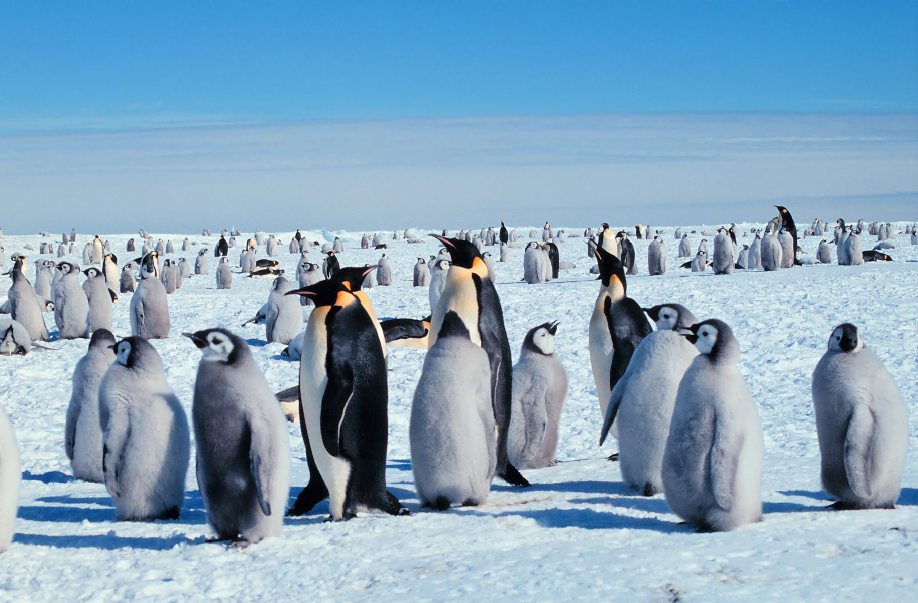
A wide shot of a large emperor penguin colony on a flat, snow-covered ice expanse under a clear blue sky, featuring adult penguins and many fuzzy grey chicks.
A large colony of adult and juvenile emperor penguins gathered on the Antarctic sea ice at Amanda Bay.

Amanda Bay history and protected-area timeline

The coastline near Amanda Bay was first sighted and named the Ingrid Christensen Coast by Captain Mikkelsen of the Norwegian ship Thorshavn on 20 February 1935. In the following years, the coast was photographed from the air during a 1937 expedition financed by Lars Christensen, and later during the United States Navy's Operation Highjump in 1947.

The Australian National Antarctic Research Expeditions (ANARE) explored the waters of Prydz Bay during the 1954-55 summer season aboard the Kista Dan. The first recorded landing in the region took place on 5 February 1955, when a sledging party led by Phillip Law reached Lichen Island. ANARE aerial photography from 1957 to 1960 further documented the coastline and led to direct human contact with the bay itself.

The first recorded visit to Amanda Bay occurred in August 1957, when a surveying party from Davis Station reached the area. During the return flight, the bay was photographed and named after Amanda, the newly-born daughter of the pilot, RAAF Squadron Leader Peter Clemence. The alternate name Hovde Cove reflects the later recognition of the bay's geographic context alongside the Hovde Glacier and Hovde Island.

Amanda Bay landscape and geographic character

Amanda Bay occupies a deeply glaciated section of the East Antarctic coast, where rock exposures are limited and the dominant scenery is shaped by ice. To the south-west, the Flatnes Ice Tongue juts out from the coastline into Prydz Bay, while Cowell Island anchors the outer corner of this icy peninsula. The bay's eastern and southern walls are formed by the ice cliffs of the Hovde Glacier, with Hovde Island standing offshore in the north-east.

Within the bay itself, small islets and scattered offshore rocks break up an otherwise continuous ice surface. Fast ice usually fills Amanda Bay throughout the year, even in mid-summer, creating a stable, white expanse that contrasts with the open waters of Prydz Bay beyond. The result is a coastal landscape defined by the interplay between grounded and floating ice, with fragmented rock exposures only emerging where the glaciers, ice tongues, and islands meet the sea.

Amanda Bay ecosystems, habitats, and plant life

Amanda Bay is embedded in the cold, low-productivity ecosystem typical of the East Antarctic coast, where the combination of sea ice, glacial discharge, and short polar summers shapes a highly specialized marine and coastal environment. The bay supports a relatively simple food web, but one of strong regional importance because of its predictable sea-ice conditions and access to the productive waters of Prydz Bay.

Vegetation is essentially absent on this part of the Ingrid Christensen Coast. The ecological value of the bay lies in its role as a stable platform for ice-dependent marine life, particularly breeding seabirds that rely on fast ice as a secure substrate. The surrounding waters and adjacent ice features, including the Flatnes Ice Tongue and Hovde Glacier, contribute to the circulation and ice dynamics that influence this coastal ecosystem.

Amanda Bay wildlife and species highlights

The most prominent wildlife feature of Amanda Bay is its emperor penguin colony at the south-west corner of the bay, where several thousand pairs breed each year on the sea ice. Emperor penguins are the largest penguin species and uniquely adapted to the extreme Antarctic winter, relying on stable fast ice to complete their long breeding cycle. The size of the Amanda Bay colony places it among the significant emperor penguin localities in East Antarctica.

Beyond the penguins, the bay and its surrounding waters are part of a broader Southern Ocean ecosystem that includes other seabirds, marine predators, and the lower trophic levels that sustain them, all dependent on the same annual cycle of sea-ice advance and retreat around East Antarctica.

Amanda Bay conservation status and protection priorities

Amanda Bay is formally protected as Antarctic Specially Protected Area No. 169 under the Antarctic Treaty System, an international designation that restricts human activity in the area to protect its outstanding environmental and scientific values. The principal reason for this designation is the bay's emperor penguin colony, which would be vulnerable to disturbance, pollution, and climate-related changes in sea-ice conditions.

The site has additionally been recognized as an Important Bird Area by BirdLife International, reinforcing its international importance for bird conservation. Together, the ASPA designation and the Important Bird Area listing position Amanda Bay as a globally significant site for the protection of Antarctic seabird habitat and the ecosystems dependent upon it.

Amanda Bay cultural meaning and human context

Amanda Bay does not have a sustained human cultural or indigenous dimension in the conventional sense; it lies on a remote stretch of the East Antarctic coast that has no permanent human population. The human history of the area is one of exploration, mapping, and scientific research by Norwegian and Australian expeditions during the twentieth century, reflected in the Norwegian-derived place names of the coast and the Australian-named bay itself. The naming of the bay after the daughter of a RAAF pilot gives the site a modest personal dimension within the broader narrative of mid-twentieth-century Antarctic exploration.

Top sights and standout views in Amanda Bay

Amanda Bay's strongest point of distinction is its emperor penguin colony of several thousand breeding pairs on the sea ice, supported by the bay's persistent fast ice. This combination of wildlife abundance and stable sea-ice conditions is unusual even within Antarctica and has driven the bay's international recognition.

Equally notable is the surrounding landscape, where the Flatnes Ice Tongue, the ice cliffs of the Hovde Glacier, and offshore islands such as Cowell Island and Hovde Island create a textbook example of an East Antarctic coastal inlet. The bay's formal protection as ASPA No. 169 and recognition as an Important Bird Area underline the global value of this compact but ecologically rich site.

Best time to visit Amanda Bay

Amanda Bay is an extremely remote Antarctic site, and access is generally tied to the austral summer, when sea-ice conditions tend to be most navigable for research and expedition vessels and when the emperor penguin colony is at its most active. In summer, the surrounding coast experiences near-continuous daylight, while the bay itself remains largely filled with fast ice, maintaining the stable platform that the penguins depend on.

Winter conditions in this part of East Antarctica are severe, with extended darkness, very low temperatures, and extensive sea-ice cover that effectively closes off the area to most visitors. Anyone considering going to Amanda Bay in person should treat this as a challenging polar expedition rather than a conventional park visit, and should plan around the Antarctic research season and the operational constraints of working in the Prydz Bay region.
Monthly climate preview

Track monthly temperature variations and precipitation averages across the protected terrain

Amanda Bay Climate Normals and Long Term Temperature Patterns

Long term records for Amanda Bay reveal consistent annual temperature variations alongside sustained monthly precipitation patterns measured at representative coordinates. Reviewing the complete twelve month profile provides deeper insight into historical climate trends and multi year temperature ranges across the protected landscape.
Annual mean-11 °C
-18 °C-1 °C
Jan-1°
Feb-4°
Mar-9°
Apr-15°
May-16°
Jun-16°
Jul-17°
Aug-18°
Sep-16°
Oct-13°
Nov-6°
Dec-2°
Warmest month
January

-1.2 °C

Coolest month
August

-17.6 °C

Wettest month
March

1.5 mm/day

Driest month
January

0.7 mm/day

Park location guide

Geography guide, regional context, and park location map for Amanda Bay

Amanda Bay park geography, regions, and map view in Antarctica

Understand where Amanda Bay sits in Antarctica through a broader geographic reading of the surrounding landscape, nearby location context, and its mapped position within the national park landscape.

How Amanda Bay fits into Antarctica

Centered on the South Pole, Antarctica is the highest, driest, coldest and windiest continent. Almost all of its land is buried beneath ice, yet its coasts and surrounding ocean sustain globally significant colonies of penguins, seals and seabirds.

Wider geography shaping Amanda Bay in Antarctica

The continent surrounds the geographic South Pole and is separated from other landmasses by the Southern Ocean. A vast ice sheet conceals mountain ranges, basins and plains, exceeds four kilometres in thickness in places and flows outward through glaciers and floating ice shelves. The Transantarctic Mountains divide East and West Antarctica, while the Antarctic Peninsula reaches north toward South America.

Map view of Amanda Bay

Use this park location map to pinpoint Amanda Bay in Antarctica, understand its exact geographic position, and read its mapped placement within the surrounding landscape more clearly.

Pigeon | © OpenStreetMap contributors

Location context for Amanda Bay

East Antarctica

Visual references of fast ice, towering glacier cliffs, and protected polar habitats

Amanda Bay Photos and Scenery: Exploring the Glacial Coastline and Wildlife

Visual documentation of Amanda Bay reveals the striking intersection of persistent fast ice, towering glacier walls, and major emperor penguin breeding colonies. Photographic records provide clear insight into the remote Antarctic terrain and protected coastal habitats that define the region.

A wide shot of a large emperor penguin colony on a flat, snow-covered ice expanse under a clear blue sky, featuring adult penguins and many fuzzy grey chicks.

Park atlas

Compare adjacent polar landscapes and regional wildlife habitats across the East Antarctic coast

Parks Near Amanda Bay and Other Protected Coastal Areas to Explore Next

Browse protected areas near Amanda Bay to discover similar glacial inlets and remote coastal ecosystems. Regional park comparison reveals broader patterns of sea ice distribution and marine wildlife habitats across the continent.
Protected areaMac. Robertson Land
About 445 km away#1 closest

West

Scullin Monolith Protected Area in East Antarctica: Coastal Geography and Habitat Atlas

Ice-free coastal terrain and regional seabird breeding grounds

Scullin Monolith represents a singular landmark of exposed rock along the glaciated coastline of Mac. Robertson Land. Stretching from Mikkelsen Peak toward Douglas Bay, this crescent-shaped promontory remains essential for understanding East Antarctic coastal geography and the dense avian populations that rely on its rare snow-free terrain and protective vertical cliffs.

Established
1931
Relief
Upland
Climate
Polar
Access
Remote access
Protected areaMac. Robertson Land
About 613 km away#2 closest

West

Rookery Islands Protected Area: Mac. Robertson Land Polar Landscape Atlas

Coastal rocky terrain and international seabird conservation zone

Located in western Holme Bay, the Rookery Islands form a protected rocky archipelago along the Mawson Coast. This site functions as a key reference area for polar seabird populations, including Adélie penguins and southern giant petrels, while providing a clear contrast to the high-relief mountain ranges of the Antarctic mainland.

Area
0.89 km²
Relief
Lowland
Climate
Polar
Access
Remote access
Wildlife reserveAntarctica
About 684 km away#3 closest

West

Taylor Rookery Wildlife Reserve: Antarctic Protected Landscape and Research Site

Mapping a unique land-based penguin colony on the Mawson Coast.

Located on the Mawson Coast of East Antarctica, Taylor Rookery is a protected wildlife reserve of high scientific importance. This site serves as a vital benchmark for emperor penguin population studies, featuring a rare landscape of rocky outcrops that support land-based breeding. Its unique geography, framed by Taylor Glacier and the Colbeck Archipelago, provides a stable environment for observing one of the most monitored polar colonies in the region.

Area
0.26 km²
Relief
Lowland
Climate
Polar
Access
Remote access
Protected areaAntarctica
About 1,431 km away#4 closest

East

Frazier Islands Protected Area: Geographic Boundaries and Antarctic Coastal Context

Rocky island terrain within the Vincennes Bay coastal region

Examine the rugged profile of the Frazier Islands, a group of three ice-free rocky outcrops rising from the Southern Ocean. Their protected status and specialized role as a rare continental seabird breeding ground offer a distinct lens into the regional geography and conservation landscapes of East Antarctica.

Relief
Lowland
Climate
Polar
Access
Remote access
Scope
Marine
Protected areaAntarctica
About 1,434 km away#5 closest

East

Ardery Island: Protected Coastal Geography and Antarctic Seabird Habitats

Rugged terrain and avian conservation in the Windmill Islands

Ardery Island represents a compact, rocky protected area within the Antarctic landscape. Known for its steep cliffs and essential seabird colonies, this island serves as a focal point for ecological study along the Budd Coast, offering a distinct example of high-latitude coastal geography.

Relief
Upland
Climate
Polar
Access
Remote access
Scope
Mixed
Protected areaAntarctica
About 1,444 km away#6 closest

East

Clark Peninsula: Antarctic Protected Landscape and Coastal Geographic Atlas

Ice-free rocky terrain on the Budd Coast of Wilkes Land

Clark Peninsula provides a window into the unique geography of East Antarctica, featuring exposed rocky outcrops, coastal coves, and significant glacial moraines. As a dedicated protected area, the site supports long-term ecological research and provides a critical habitat for seabird colonies, offering a detailed look at the interface between continental ice and the Southern Ocean.

Area
9.4 km²
Relief
Lowland
Climate
Polar
Access
Remote access
A pale, minimalist watercolor illustration of soft rolling green hills, a tree line, and a body of water in the foreground, against a plain white background.
Protected areaAustralian Antarctic Territory
About 2,616 km away#7 closest

Southeast

Mawson's Huts Protected Area: Antarctic Heritage and Coastal Geographic Landscape

Historic polar structures in the Australian Antarctic Territory

Located at Cape Denison, Mawson's Huts represents a rare preserved footprint of the Heroic Era of Antarctic exploration. The site encompasses specialized scientific buildings set against a challenging coastal landscape, offering insight into the logistical history of polar science within the Australian Antarctic Territory.

Established
1912
Relief
Lowland
Climate
Polar
Access
Remote access
Nature reserveWestern Cape
About 3,273 km away#8 closest

Northwest

Prince Edward Islands Nature Reserve: Subantarctic Volcanic Landscape and Marine Geography

Remote volcanic terrain and protected ocean boundaries in the southern Indian Ocean.

Discover the geographic profile of the Prince Edward Islands, an uninhabited volcanic nature reserve. Analyze the rugged cliff-lined coastlines, peat-covered uplands, and the surrounding marine protected area that safeguards essential habitats for penguins and threatened seabird species in the southern Indian Ocean.

Area
343 km²
Established
2003
Relief
Mountain
Climate
Tropical

Common questions about visiting, size, designation, and location context for Amanda Bay

Amanda Bay FAQs for park facts, access, geography, and protected area context

Find quick answers about Amanda Bay, including protected-area facts, park geography, trail and visitor context, and how the park fits into its surrounding country and regional landscape.
MoriAtlas Explorer

Continue Your Protected Areas Search Across the Global Atlas

Deepen your exploration by continuing the structured search for national parks and protected areas worldwide. Utilize the comprehensive filtering capabilities to compare different conservation landscapes and refine your understanding of global park geography. Discover more about the distribution and characteristics of protected natural areas.

Global natural geography
