Mori Atlas logo
National parkParc national du Badiar

Tracing the geographic extent of a transboundary West African biosphere reserve and riverine corridor

Parc national du Badiar: Mapped Boundaries and Protected Savanna Landscapes in Boké, Guinea

Parc national du Badiar encompasses a vast expanse of Sudano-Guinean savanna and riverine gallery forests within the Boké region of Guinea. This protected area functions as a key ecological anchor for regional wildlife connectivity, sharing a continuous habitat boundary with neighboring protected lands. The terrain is defined by undulating plains, seasonal river corridors, and a distinct mosaic of woodland and grassland habitats that sustain high levels of biodiversity across the West African landscape.

savannagallery forestbiosphere reservetransboundary parkWest African wildliferiverine habitat

Parc national du Badiar

National park

Park overview

Structured park overview, official facts, and landscape profile for Badiar National Park

Badiar National Park park facts, protected area profile, and essential visitor context

Review the core facts for Badiar National Park, including designation, size, terrain, visitor scale, habitats, and operating context in one park-focused overview.

About Badiar National Park

Badiar National Park is a protected natural area in northern Guinea, in the Badiar region close to the prefecture of Koundara and immediately adjacent to the border with Senegal. Established as a national park in 1985, it covers 37,000 hectares of Sudano-Guinean savanna punctuated by narrow corridors of gallery forest that follow the rivers crossing the terrain. Together with Senegal's Niokolo-Koba National Park, Badiar forms one of the largest continuous blocks of formally protected savanna in West Africa.

Beyond its geographic continuity with Niokolo-Koba, Badiar is recognized internationally for being designated a UNESCO Biosphere Reserve in 2002. This dual national and international protection status underlines its role as a refuge for Sudano-Guinean fauna, including populations of chimpanzee, lion, hippopotamus, and many large herbivores that benefit from the park's mix of open grasslands, riverine forests, and wooded savanna.

The reserve sits within the broader Bafing-Badiar ecological framework, a transboundary landscape that has been the focus of conservation initiatives linking Badiar with the Moyen-Bafing protected area. European Union-backed programs have supported coordinated management between the two parks, with particular emphasis on maintaining habitat corridors for wide-ranging mammals. Although the park was historically affected by pressures such as poaching and deforestation along its agricultural margins, conservation projects continue to address these threats through community engagement and cross-border collaboration.

While the park remains less developed in terms of tourist infrastructure compared to Niokolo-Koba on the Senegalese side, both parks are legally accessible across the border and offer a combined wilderness experience for travelers interested in West African savanna landscapes. Visitors typically encounter a mosaic of habitats, ranging from dry wooded savanna to dense riverine forest, supporting a notably high diversity of birds and mammals over a relatively compact area.

Quick facts and research context for Badiar National Park

Badiar National Park lies in the Boké administrative region of Guinea, specifically within the prefecture of Koundara, very close to the Senegalese frontier. Created as a national park in 1985, it was added to UNESCO's list of biosphere reserves in 2002, reflecting both its ecological value and its transboundary role. The protected area is classified as IUCN Category II and encompasses roughly 37,000 hectares of Sudano-Guinean savanna with gallery forests lining the main river systems.

Most significantly, Badiar forms the northern Guinean half of a contiguous protected landscape that includes Senegal's Niokolo-Koba National Park, allowing free movement of wildlife across the border and supporting coordinated EU-funded conservation programs. The park hosts approximately 78 mammal species and around 300 bird species, and it serves as a recognized refuge for chimpanzee populations in the broader Bafing-Badiar corridor.

Protection and recognition

Documented terrestrial protection scope, management context, and international registry identifiers

Parc National du Badiar Protection Status and Transboundary Protected Area Records

Terrestrial protection records for Parc national du Badiar outline its established conservation status and transboundary landscape framework. Verified database identifiers and recognition parameters provide structured insight into the legal boundaries of this protected area.

Protection details

Protection scope
Terrestrial
Transboundary protection
Yes
WDPA ID
29069
Park context

Deeper park guide and search-rich context for Badiar National Park

Badiar National Park history, landscape, wildlife, and travel context

Explore Badiar National Park through its history, landscape character, ecosystems, wildlife, conservation priorities, cultural context, and seasonal travel timing in a structured park guide built for atlas discovery and search intent.

Why Badiar National Park stands out

Badiar is best known as the Guinean counterpart in a cross-border conservation landscape centered on Niokolo-Koba. Its open Sudano-Guinean savanna, gallery forests along the Koulountou and neighboring rivers, and rich mammal community make it a key node in the West African savanna biodiversity network. The park also draws recognition for its UNESCO Biosphere Reserve status, granted in 2002, and for being part of a transboundary corridor project connecting the Moyen-Bafing and Badiar protected areas, an initiative backed by European Union funding and aimed at reinforcing landscape connectivity for large mammal populations, including chimpanzees.
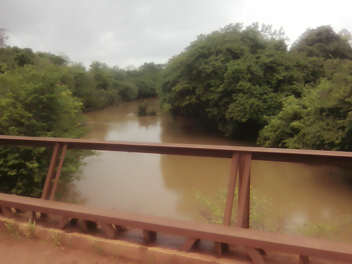
A reddish-brown metal bridge railing in the foreground with a muddy brown river and dense green trees on both banks under a cloudy gray sky
View from the Koulountou bridge over a muddy river flanked by dense gallery forest under overcast skies

Badiar National Park history and protected-area timeline

Badiar National Park was formally established in 1985, reflecting Guinea's interest in formal protection of the savanna landscapes along its northern border with Senegal. From the early years of its existence, the park's conservation relevance was understood in transboundary terms, given its direct adjacency to Senegal's Niokolo-Koba National Park and the shared wildlife populations that cross the frontier.

In 2002, Badiar's profile rose considerably when it was inscribed as a UNESCO Biosphere Reserve. The designation recognized not only the park's intrinsic ecological value but also its role within a wider Sudano-Guinean landscape that connects protected areas across the border. This milestone strengthened institutional interest in coordinated management and opened the door to regional conservation partnerships.

Since the early 2000s, Badiar has been at the center of a transboundary conservation corridor linking it to the Moyen-Bafing National Park, with implementation supported by the European Union. These initiatives have focused on anti-poaching measures, habitat connectivity, and the management of agricultural pressure along the park's edges, particularly affecting chimpanzee populations and forested river margins. Although the park faced documented challenges from poaching and agricultural encroachment in the early 2020s, ongoing conservation efforts continue to reinforce its role as a key refuge in the West African savanna network.

Badiar National Park landscape and geographic character

Badiar's physical setting is defined by the rolling Sudano-Guinean savanna that characterizes much of southeastern West Africa. The terrain consists largely of open grasslands and lightly wooded savanna, broken by river systems that cut narrow gallery forest corridors through the otherwise dry landscape. The most prominent of these waterways is the Koulountou, whose riverine vegetation offers a striking contrast to the surrounding open plains.

The climate supports a strongly seasonal landscape, with wet-season growth greening the savanna and dry-season conditions producing the more open, golden character typical of West African savanna ecosystems. Soils along the river margins sustain denser vegetation, while the upland savanna is dominated by characteristic tree genera such as Combretum and Terminalia, which together define the woody structure of the habitat.

Topographically the park is undulating rather than mountainous, with a generally gentle relief shaped by the network of seasonal rivers. This combination of open savanna and forested river corridors produces a visually varied landscape in which the transition from dry grassland to lush gallery forest can occur within very short distances, a pattern that strongly shapes the distribution of wildlife throughout the park.

Badiar National Park ecosystems, habitats, and plant life

Badiar's ecological identity rests on the interplay between extensive Sudano-Guinean savanna and the gallery forests that follow the park's rivers. This mosaic supports a far richer range of habitats than open savanna alone would, and it underpins the unusually high biodiversity observed across both faunal and floral groups.

Vegetatively, the park's woodlands are dominated by Combretum and Terminalia species, two tree genera emblematic of West African dry-forest and savanna systems. Along the rivers, denser and more humidity-loving plant communities take over, producing the ribbon-like gallery forests that are ecologically critical for many of the park's mammals and birds. These forest corridors also play an important role in dispersing species and maintaining genetic connectivity across the wider landscape.

Seasonality strongly structures the ecology of Badiar. During the wet season, the savanna recovers its green cover and many herbivores benefit from the renewed flush of grasses and foliage. In the dry season, wildlife concentrates more heavily around the permanent rivers and gallery forests, where shade, water, and food resources remain available. This seasonal rhythm shapes movements of large mammals and influences the distribution of birdlife throughout the year.

Badiar National Park wildlife and species highlights

Badiar supports a diverse community of large mammals typical of West African savanna ecosystems. The park records around 78 mammal species, including populations of hippopotamus along the river systems, chimpanzee in the forested corridors, and a range of other herbivores and predators that benefit from the contiguous habitat shared with Niokolo-Koba. Lion, various antelope species, and primates are notable presences within this broader assemblage.

The park is also significant for its birdlife, with around 300 recorded species reflecting the rich interface between open savanna, riverine forest, and water habitats. Among the more conspicuous species is the red-billed hornbill, whose dry-savanna ecology is well represented by the park's open woodland environments. The mix of dry-country birds and forest-dependent species gives Badiar particular interest for birdwatchers interested in West African avifauna.

The transboundary connection with Niokolo-Koba is ecologically vital for Badiar's wildlife. Many species move freely across the border, and the unfenced continuity between the two parks effectively enlarges the available habitat for wide-ranging mammals and migratory birds. This shared landscape, however, also exposes Badiar's wildlife to pressures such as poaching and deforestation along the agricultural margins, both of which have been identified as significant threats to species such as chimpanzees in recent assessments.

Badiar National Park conservation status and protection priorities

Conservation at Badiar operates on multiple scales, from national park status to international recognition and transboundary cooperation. Classified as an IUCN Category II protected area, the park was established in 1985 and subsequently inscribed as a UNESCO Biosphere Reserve in 2002, reinforcing its profile as a key site for Sudano-Guinean biodiversity protection.

A defining element of Badiar's conservation strategy is its integration into a transboundary corridor with Senegal's Niokolo-Koba and with the Moyen-Bafing National Park to the south. Since 2002, programs supported by the European Union have worked to maintain ecological connectivity across these landscapes, recognizing that the long-term viability of the park's wildlife depends on coordinated management across national boundaries. The corridor approach is particularly important for wide-ranging species such as chimpanzees, elephants, and large carnivores that do not respect park borders.

Despite its protected status, Badiar faces ongoing threats. A 2023 report from WildGuinea highlighted the role of poaching in driving declines in chimpanzee populations and identified deforestation linked to agricultural expansion on the edges of the park as a significant pressure. Conservation projects responding to these threats generally combine anti-poaching enforcement, habitat monitoring, and community engagement along the park's agricultural frontier, recognizing that the long-term integrity of the reserve depends as much on its surrounding land-use patterns as on activities within its boundaries.

Badiar National Park cultural meaning and human context

Badiar lies in the Badiar region of northern Guinea, an area historically shaped by the interplay of Guinean and Senegalese cultural landscapes along an open frontier. Because the park's borders effectively cross international lines, the local cultural context is best understood as transboundary, with communities on both sides of the border historically sharing ecological resources, migration routes, and seasonal movements tied to the savanna and the rivers.

The park's agricultural edge, where farming communities meet the protected area, defines much of its present-day human context. Conservation programs operating in and around the park frequently acknowledge this cultural and economic relationship, working to balance the livelihoods of local residents with the protection of wildlife habitat and the maintenance of the gallery forests along the park's rivers. The shared cultural landscape with the Niokolo-Koba side of the frontier further reinforces the transboundary character of human and ecological life in this region.

Top sights and standout views in Badiar National Park

Badiar's strongest identity marker is its role as the Guinean half of a major West African transboundary ecosystem, anchored by Niokolo-Koba on the Senegalese side. The combination of UNESCO Biosphere Reserve status, IUCN Category II protection, and active EU-supported corridor programs makes Badiar unusually well integrated into wider regional conservation frameworks.

Ecologically, the park's gallery forests along rivers like the Koulountou, its Combretum- and Terminalia-dominated savanna, and its support for approximately 78 mammal species and 300 bird species give it a distinctly rich profile within the Sudano-Guinean biome. These features together make Badiar a meaningful destination for travelers seeking a less-visited but ecologically connected counterpoint to the better-known Niokolo-Koba landscape across the border.

Best time to visit Badiar National Park

Badiar's character shifts significantly between the wet and dry seasons, and the choice of timing should reflect what kind of landscape and wildlife experience a visitor seeks. During and shortly after the rainy season, the savanna greens up, grasses and foliage are abundant, and wildlife is more widely dispersed across the park. Bird activity is also high during this period, with many resident and migratory species actively breeding or feeding.

In the dry season, the park takes on a more openly visible character, with shorter grass, thinner canopy, and wildlife concentrating around the river systems and gallery forests. This concentration can make mammal viewing along the Koulountou and related rivers more rewarding, while also lending the landscape the classic golden-savanna atmosphere associated with West African dry-season imagery. Visitors considering a combined experience with Niokolo-Koba should note that practical facilities remain more developed on the Senegalese side throughout the year, regardless of season.

Monthly climate preview

Long-term representative temperature and precipitation averages for Parc national du Badiar

Parc national du Badiar Climate Normals, Annual Temperature, and Precipitation Rhythm

Long-term coordinate measurements reveal significant annual temperature shifts and marked monthly precipitation variations across Parc national du Badiar. Examining the complete twelve-month climatology record provides detailed insight into average temperature ranges and precipitation patterns.
Annual mean28 °C
25 °C33 °C
Jan27°
Feb29°
Mar32°
Apr33°
May33°
Jun29°
Jul27°
Aug26°
Sep26°
Oct26°
Nov25°
Dec25°
Warmest month
April

33.3 °C

Coolest month
December

24.8 °C

Wettest month
August

12.6 mm/day

Driest month
December

0 mm/day

Park location guide

Geography guide, regional context, and park location map for Badiar National Park

Badiar National Park park geography, regions, and map view in Guinea

Understand where Badiar National Park sits in Guinea through a broader geographic reading of the surrounding landscape, nearby location context, and its mapped position within the national park landscape.

How Badiar National Park fits into Guinea

Guinea is a West African country with a population of approximately 14 million people. The country achieved independence from France in 1958 and is known for its diverse geography ranging from coastal lowlands to highland plateaus. Conakry serves as both the capital and largest city. Guinea is a member of the United Nations, ECOWAS, the African Union, and La Francophonie.

Wider geography shaping Badiar National Park in Guinea

Guinea is located on the West African Atlantic coast, bordered by Guinea-Bissau to the northwest, Senegal to the north, Mali to the northeast, Ivory Coast to the southeast, and Sierra Leone and Liberia to the south. The country is divided into four geographic regions: Maritime Guinea along the Atlantic coast, the Fouta Djallon highlands in Middle Guinea, the Upper Guinea savanna in the northeast, and the forested Guinea region in the southeast.

Map view of Badiar National Park

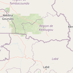
Use this park location map to pinpoint Badiar National Park in Guinea, understand its exact geographic position, and read its mapped placement within the surrounding landscape more clearly.

Pigeon | © OpenStreetMap contributors

Location context for Badiar National Park

Boké

Visual reference collection highlighting Sudano-Guinean savanna and riverine habitats

Parc National du Badiar Landscape Photos and Protected Area Scenery

Examine professional field photography documenting the open grasslands, river corridors, and gallery forests defining Parc national du Badiar. Visual documentation provides direct insight into the undulating terrain and transboundary habitat mosaic characterizing this West African protected area.

A reddish-brown metal bridge railing in the foreground with a muddy brown river and dense green trees on both banks under a cloudy gray sky

A group of hippopotamuses partially submerged in a muddy river, with several standing on the sandy bank.

Park atlas

Compare transboundary savanna ecosystems and regional wildlife corridors.

Parks Near Parc National du Badiar and Surrounding Protected Areas

Browsing other protected areas near Parc national du Badiar reveals connected Sudano-Guinean savanna habitats and riverine gallery forests across the border. Regional park comparison provides valuable geographic context for understanding wider West African conservation landscapes.
National parkSenegal
About 2.8 km away#1 closest

Northeast

Niokolo-Koba National Park: Exploring Senegal's Protected Landscape Identity

Mapped boundaries and regional geography context.

Niokolo-Koba National Park offers a distinct focus on Senegal's protected landscapes, providing valuable insights for atlas and map-based exploration. This national park serves as a key geographic anchor, highlighting the natural terrain and the extent of its protected boundaries within the country. Users can delve into the specific characteristics of this area to understand its role within Senegal's diverse natural heritage and regional geography.

Area
9,130 km²
Established
1954
IUCN
II
Relief
Upland
National parkGuinea
About 3.9 km away#2 closest

Southwest

Badiar National Park: A Transboundary Protected Landscape in Northeastern Guinea

Exploring savanna ecosystems and riverine corridors

Badiar National Park encompasses over 1,200 square kilometers of diverse West African terrain in northeastern Guinea. This protected area features a unique mosaic of open woodlands, savanna, and lush gallery forests along the Koulountou River. Serving as a transboundary ecological link, the park provides an essential habitat corridor that is critical for regional biodiversity and landscape-scale conservation planning within the West African savanna belt.

Area
1,228 km²
Established
1985
IUCN
II
Climate
Tropical
Protected areaGuinea
About 129 km away#3 closest

Southeast

Forêt classée de Nialama: Protected Landscape and Fouta Djalon Highland Geography

Exploring the forest mosaic and habitat boundaries in Guinea.

Forêt classée de Nialama represents a complex protected landscape covering 10,000 hectares of the Fouta Djalon highlands. The area features a distinct blend of gallery forest, bamboo stands, and seasonal wetlands. Known for its role in chimpanzee conservation and avian diversity, this site offers a window into the varied Sudano-Guinean terrain and highland forest ecosystems of Guinea.

Area
100 km²
Protected areaGuinea
About 183 km away#4 closest

South

Rio Pongo: A Protected Estuarine Wetland Landscape in Coastal Guinea

Mapping mangrove forests, tidal mudflats, and coastal ecology

Rio Pongo is a prominent protected area in Guinea, characterized by a complex network of brackish tidal channels and dense mangrove forests. The site serves as a crucial habitat for waterbirds and aquatic mammals, while its position at the edge of the Atlantic Ocean defines a dynamic, low-lying coastal terrain that remains vital for regional conservation and ecological research.

Area
300 km²
Established
1992
Water
Water-dominated
Watercolor illustration of a river flowing through a landscape with trees, grassy areas, and distant hills under a soft sky
National parkCentral River Division
About 212 km away#5 closest

Northwest

River Gambia National Park: National Park Geography and Protected Landscape Atlas

Discover mapped boundaries within Central River Division.

River Gambia National Park represents a key protected area within the Central River Division, offering specific geographic insights for atlas exploration. This page details the park's mapped boundaries and its role as a national park, providing a factual basis for understanding its landscape context and regional importance. Explore the geographic features that define this protected natural area.

Area
5.85 km²
Established
1978
IUCN
II
Relief
Lowland
National parkGuinea-Bissau
About 216 km away#6 closest

Southwest

Cufada National Park: Guinea-Bissau's National Park Protected Landscape Identity

Mapped geography and protected area context for exploration.

Discover the geographic setting and protected landscape of Cufada National Park, a designated national park in Guinea-Bissau. This destination offers insights into the park's mapped boundaries and its role within the nation's natural terrain, providing valuable context for anyone exploring West African protected areas and regional geography through an atlas lens.

Protected areaGuinea-Bissau
About 216 km away#7 closest

Southwest

Lagoas Cufada Natural Park: Explore Guinea-Bissau's Protected Area Geography and Mapped Landscape

Regional geographic context and protected landscape identity.

Lagoas Cufada Natural Park represents a key protected area within Guinea-Bissau, contributing to the nation's conservation landscape. This entry focuses on its geographic identity, providing users with mapped boundary information and an understanding of its place within the regional geography. It serves as a foundation for exploring the park's specific natural landscape characteristics and its atlas-based significance.

National parkGuinea-Bissau
About 239 km away#8 closest

Southwest

Cantanhez Forests National Park: A Protected Landscape within Guinea-Bissau's Geography

Explore mapped boundaries and regional landscape context.

Cantanhez Forests National Park stands as a notable protected area, providing a specific lens through which to understand the natural geography of Guinea-Bissau. This entry facilitates an atlas-style examination of the park's identity, focusing on its landscape character and its position within the regional geographic framework of West Africa. Delve into the structured information to appreciate the unique protected-area context that Cantanhez Forests National Park contributes to the country's mapped natural heritage.

IUCN
II
Scope
Terrestrial

Common questions about visiting, size, designation, and location context for Badiar National Park

Badiar National Park FAQs for park facts, access, geography, and protected area context

Find quick answers about Badiar National Park, including protected-area facts, park geography, trail and visitor context, and how the park fits into its surrounding country and regional landscape.
MoriAtlas Explorer

Continue Your Protected Areas Search Across the Global Atlas

Deepen your exploration by continuing the structured search for national parks and protected areas worldwide. Utilize the comprehensive filtering capabilities to compare different conservation landscapes and refine your understanding of global park geography. Discover more about the distribution and characteristics of protected natural areas.

Global natural geography