
Mori Atlas logo
Nature reserveBorcheltsbusch und Brandkieten

A vital mosaic of mixed forest, open moorland, and river corridors on the Lower Lusatian land ridge.

Borcheltsbusch und Brandkieten Nature Reserve: Mapped Geography and Protected Landscapes in Brandenburg

(Naturschutzgebiet Borcheltsbusch und Brandkieten)

Borcheltsbusch und Brandkieten forms an ecologically distinct nature reserve within the southern Brandenburg landscape, protecting over 140 hectares of mixed forest and peatland habitats. Located west of Luckau, the area is defined by the flow of the Berste river and its integration into a broader mosaic of forest and wetland corridors. This site serves as a managed stronghold for heath and bog communities, closely linked to adjacent protected zones within the Lower Lusatian region.

nature reserveBodendenburglowland forestmoorlandpeatlandwetland habitats
A flat-style digital illustration depicting a sunny mountain valley with a winding river, two waterfalls, evergreen trees, and foreground foliage.

Borcheltsbusch und Brandkieten

Nature reserve

Park overview

Structured park overview, official facts, and landscape profile for Borcheltsbusch und Brandkieten

Borcheltsbusch und Brandkieten park facts, protected area profile, and essential visitor context

Review the core facts for Borcheltsbusch und Brandkieten, including designation, size, terrain, visitor scale, habitats, and operating context in one park-focused overview.

About Borcheltsbusch und Brandkieten

Borcheltsbusch und Brandkieten is a medium-sized nature reserve in the southern part of the German state of Brandenburg, established to protect a mosaic of lowland forest, open moorland, and wet transitional habitats on the Lower Lusatian land ridge. Although modest in scale compared to some of Brandenburg's larger protected areas, the reserve carries real ecological significance because it preserves a landscape type, sandy, gently undulating terrain with isolated bog hollows and stream-influenced woodland, that has become increasingly rare under modern land use in the region.

The reserve sits on the administrative territory of the town of Luckau in the district of Dahme-Spreewald, a region otherwise known for its extensive Spreewald floodplain landscapes further north. Borcheltsbusch und Brandkieten, by contrast, belongs to the drier southern fringes of the district, where glacial sands and historically managed heath and bog landscapes dominate. Its position west of the village of Görlsdorf and south of the Luckau town center places it within easy reach of the agricultural and forested countryside that defines much of the surrounding Niederlausitzer Landrücken, or Lower Lusatian land ridge.

Ecologically, the reserve serves as a refuge for habitat types that were once more widespread across this part of Brandenburg: damp mixed forests, acidic bog communities, open moorland, and the narrow stream corridor of the Berste along its western flank. The Berste, a small left-bank tributary of the Spree, provides both hydrological input to the lower-lying wet zones and a linear ecological feature along the boundary. The inclusion of the reserve in the IUCN Category IV framework for habitat and species management areas underscores that the site is managed actively to maintain particular habitat conditions rather than left as untouched wilderness.

Conservation activity in and around the reserve has been notable. The Heinz Sielmann Stiftung, a foundation widely recognized for its work on wildlife and habitat protection in Germany, has acquired roughly 112 hectares of moorland within Borcheltsbusch in recent years. Such acquisitions are typically aimed at ensuring long-term hydrological stability and rewetting potential for the bog systems, which are otherwise vulnerable to drainage, peat extraction legacies, or changes in surrounding land use. This makes the reserve not only a statutory protected area on paper but also an actively stewarded conservation landscape.

Quick facts and research context for Borcheltsbusch und Brandkieten

Borcheltsbusch und Brandkieten is a designated nature reserve (Naturschutzgebiet) in Brandenburg, Germany, with a protected area of about 142 hectares. It lies on the territory of the town of Luckau in the Dahme-Spreewald district and was established by decree on 26 March 1981. The reserve is part of the Brandenburg protected-area network under designation 1307 and is catalogued internationally as WDPA ID 14429. Its western boundary follows the course of the Berste, a small left-bank tributary of the Spree river.

Protection and recognition

Review documented terrestrial protection scope and verified conservation recognition data

Borcheltsbusch und Brandkieten Protection Status and Official Designated Area Records

Borcheltsbusch und Brandkieten maintains a recorded terrestrial protection status within global conservation databases. Official records outline the baseline designation framework and administrative scope associated with the protected area.

Protection details

Protection scope
Terrestrial
WDPA ID
14429
Park context

Deeper park guide and search-rich context for Borcheltsbusch und Brandkieten

Borcheltsbusch und Brandkieten history, landscape, wildlife, and travel context

Explore Borcheltsbusch und Brandkieten through its history, landscape character, ecosystems, wildlife, conservation priorities, cultural context, and seasonal travel timing in a structured park guide built for atlas discovery and search intent.

Why Borcheltsbusch und Brandkieten stands out

The reserve is best known for its combination of lowland forest, open moorland (Moorflächen), and transitional wetland habitat types nestled within the agricultural landscape of Lower Lusatia. It is recognized locally and within the Brandenburg conservation network as a compact but ecologically valuable stronghold for heath, bog, and forest-edge communities typical of the sandy soils of the region. It is also notable for the active conservation engagement of the Heinz Sielmann Stiftung, which has purchased substantial moorland acreage within the Borcheltsbusch area to secure it for habitat management and rewetting. The close ecological connection to the larger adjacent Görlsdorfer Wald nature reserve further strengthens the site's role as a node in a broader mosaic of forest and mire habitats around Luckau.
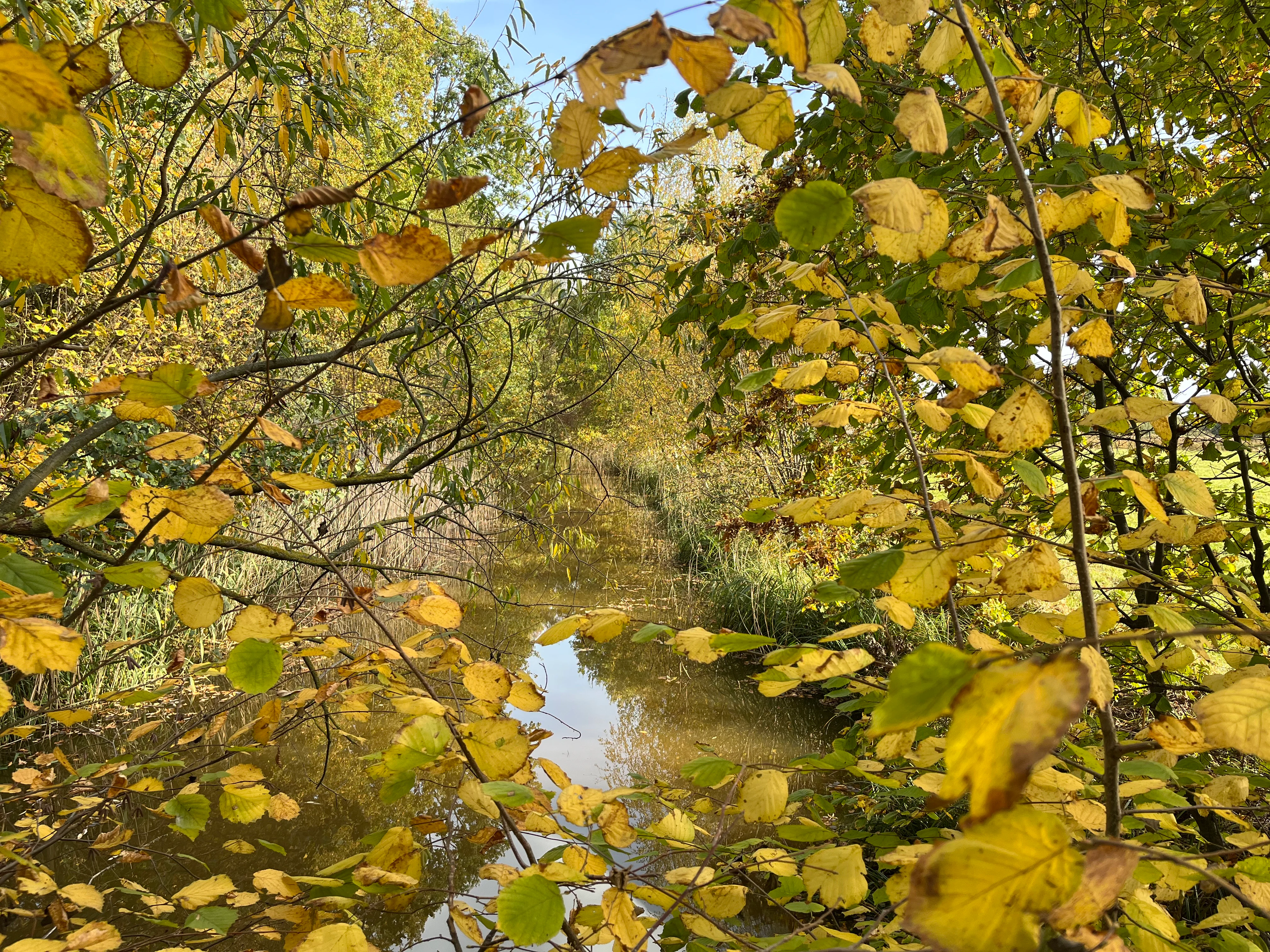
A view through yellow and green autumn leaves looking toward a narrow, calm stream in a forest.
Autumn foliage frames a small stream within the Borcheltsbusch und Brandkieten nature reserve.

Borcheltsbusch und Brandkieten history and protected-area timeline

The reserve has its formal origins in the early 1980s, when it was placed under nature protection by decree of the regional authorities on 26 March 1981. This designation, carried out under the then-applicable nature conservation law of the German Democratic Republic and continued after German reunification within the unified Brandenburg framework, gave the area its protected status under the designation number 1307.

Since then, the reserve has been maintained as a statutory Naturschutzgebiet within the broader network of Brandenburg protected areas under the Landkreis Dahme-Spreewald. In more recent years, the conservation profile of the area has been strengthened by the engagement of the Heinz Sielmann Stiftung, which has acquired approximately 112 hectares of moorland within the Borcheltsbusch portion of the protected landscape. The foundation's purchases are intended to secure the long-term management, rewetting, and habitat quality of the bog systems that form a core part of the reserve's ecological value.

In the wider Natura 2000 context, the protected landscape has been split into complementary management units: a core component of about 117 hectares and an extension of roughly 157 hectares, reflecting both the original reserve and subsequent additions that are recognized at the European level for their habitat and species importance.

Borcheltsbusch und Brandkieten landscape and geographic character

The landscape of Borcheltsbusch und Brandkieten reflects the gentle, sandy topography typical of the Lower Lusatian land ridge in southern Brandenburg. Rather than dramatic relief or large water bodies, the area is characterized by low, undulating terrain shaped by glacial deposits, interspersed with shallow depressions where peat and bog communities have developed over time. The result is a mosaic of dry forest patches, open heath-like areas, and wet hollows with moorland vegetation.

Along the western edge of the reserve flows the Berste, a modest left-bank tributary of the Spree. This small watercourse defines part of the boundary and contributes moisture and ecological connectivity to the adjacent low-lying zones. To the southeast the reserve adjoins the larger Görlsdorfer Wald, a roughly 195-hectare nature reserve dominated by continuous forest cover, effectively extending the wooded landscape around Luckau. Together, the two reserves frame an arc of forest and open bog habitat around the southern and western approaches to Luckau itself.

Borcheltsbusch und Brandkieten ecosystems, habitats, and plant life

The nature of the reserve is fundamentally shaped by the interplay between dry, sandy substrates and pockets of waterlogged, peat-forming ground. This juxtaposition produces a habitat mosaic that is notably richer than the surrounding agricultural and afforested land. Higher, drier ground supports mixed deciduous and coniferous forest communities, while lower-lying areas carry bog and moor vegetation typical of the Brandenburg lowlands, including open Moorflächen (moor surfaces) that depend on stable water tables for their continued existence.

The site is set within the broader Niederlausitzer Landrücken (Lower Lusatian land ridge), a landscape whose historical land-use patterns of heath, grazing woodland, and small-scale peat cutting have long co-existed with the modern intensive forestry and agriculture that now dominate. Reserves like Borcheltsbusch und Brandkieten act as refuges where the older land-use legacy remains in the vegetation and soil structure.

Borcheltsbusch und Brandkieten wildlife and species highlights

The combination of forest, open moorland, and a small river corridor supports a typical mix of lowland Brandenburg wildlife. Forest stands offer habitat for common woodland birds, small mammals, and a range of insects associated with both mature trees and decaying wood, while the open moor surfaces provide conditions favored by bog-adapted invertebrates, reptiles, and amphibians, including species that depend on the specific hydrology of intact peatland.

The Berste stream corridor along the western edge adds a further aquatic and riparian dimension, contributing habitat for amphibians, dragonflies, and other invertebrates, as well as for mammals that use the vegetated banks as movement routes. The reserve's management under the IUCN Category IV framework implies an explicit aim to maintain the habitat conditions that sustain such species assemblages rather than to allow purely passive protection.

Borcheltsbusch und Brandkieten conservation status and protection priorities

Conservation significance in Borcheltsbusch und Brandkieten stems primarily from the presence of actively maintained and restorable moorland, supported by mixed lowland forest and a small river system. The reserve's inclusion in the IUCN Category IV of habitat and species management areas signals that the management focus is on targeted intervention to maintain specific habitat types and the species they support, including the rewetting and stabilization of bog systems where appropriate.

The acquisition of around 112 hectares of moorland by the Heinz Sielmann Stiftung has added a practical layer of conservation activity, ensuring that key habitat patches remain under stewardship committed to long-term hydrological and ecological management. The reserve is also recognized within the European Natura 2000 framework through component sites described as 'Borcheltsbusch und Brandkieten Teil I und II' and an extension area, indicating the recognition of its habitat value at a supranational level. Together, these designations make the site a modest but genuine contributor to Brandenburg's protected-area network for peatland and forest-associated biodiversity.

Borcheltsbusch und Brandkieten cultural meaning and human context

The reserve lies in a region with a long tradition of close human interaction with marginal landscapes, including small-scale peat cutting, woodland grazing, and the management of heath and bog areas for local livelihoods. Such land uses have historically shaped the very mosaic of habitats that the reserve now protects, and the gently worked character of the surrounding landscape reflects this long co-existence between rural communities and the natural environment of the Lower Lusatian land ridge.

Top sights and standout views in Borcheltsbusch und Brandkieten

A compact yet ecologically distinct nature reserve on the Lower Lusatian land ridge, Borcheltsbusch und Brandkieten combines lowland mixed forest, open moorland, and a Berste river corridor into a habitat mosaic of clear regional value. The reserve's identity is shaped equally by its statutory protection since 1981 and by the active conservation involvement of the Heinz Sielmann Stiftung, which has secured substantial moorland acreage for long-term management.

Its connection to the adjacent Görlsdorfer Wald nature reserve and its recognition under the European Natura 2000 framework make it a meaningful node in a wider network of forest and peatland protected areas around Luckau.

Best time to visit Borcheltsbusch und Brandkieten

Because the reserve is characterized by forest and open moorland rather than alpine or highly seasonal scenery, its visual character varies mainly with the broader Brandenburg seasons. Spring and early summer bring the most active birdlife and the fresh green of the mixed forest canopy, while late summer and autumn can be rewarding for observing moorland vegetation and the changing tones of the surrounding woodland. Winter visits can offer quieter conditions and clearer views through the leafless forest, though visitors should respect the protected status of the area and follow any applicable access guidance for nature reserves in Brandenburg.


Monthly climate preview

Long term representative temperature and precipitation patterns across twelve months

Borcheltsbusch und Brandkieten Climate Normals and Annual Weather by Month

Representative coordinates record annual temperature progression alongside steady daily precipitation averages across twelve recorded intervals. Examining the complete monthly climate dataset provides structured context for long term meteorological norms at this protected location.
Annual mean10 °C
-1 °C21 °C
Jan-1°
Feb
Mar
Apr
May14°
Jun18°
Jul21°
Aug20°
Sep15°
Oct
Nov
Dec
Warmest month
July

20.6 °C

Coolest month
January

-0.8 °C

Wettest month
July

2.5 mm/day

Driest month
April

1.1 mm/day

Park location guide

Geography guide, regional context, and park location map for Borcheltsbusch und Brandkieten

Borcheltsbusch und Brandkieten park geography, regions, and map view in Germany

Understand where Borcheltsbusch und Brandkieten sits in Germany through a broader geographic reading of the surrounding landscape, nearby location context, and its mapped position within the national park landscape.

How Borcheltsbusch und Brandkieten fits into Germany

Germany is a federal republic in Western and Central Europe with a population of over 83 million across sixteen constituent states. It is Europe's largest economy by nominal GDP and a major global exporter and importer. The capital is Berlin, and the country borders Denmark, Poland, Czech Republic, Austria, Switzerland, France, Luxembourg, Belgium, and the Netherlands.

Wider geography shaping Borcheltsbusch und Brandkieten in Germany

Germany is located in Western and Central Europe, spanning 357,022 km². It borders Denmark to the north, Poland and the Czech Republic to the east, Austria and Switzerland to the south, and France, Luxembourg, Belgium, and the Netherlands to the west. The country has coastlines on the Baltic Sea and North Sea to the north, with the Alps located in the southern region.

Map view of Borcheltsbusch und Brandkieten

Use this park location map to pinpoint Borcheltsbusch und Brandkieten in Germany, understand its exact geographic position, and read its mapped placement within the surrounding landscape more clearly.

Pigeon | © OpenStreetMap contributors

Location context for Borcheltsbusch und Brandkieten

Brandenburg

Visual reference for lowland forest, moorland habitats, and protected terrain

Borcheltsbusch und Brandkieten Photos and Landscape Scenery

Photographic records reveal the distinct lowland forest patches, open moorland, and wetland terrain defining Borcheltsbusch und Brandkieten. Visual exploration helps researchers examine the habitat mosaic and protected landscape character preserved across the Lower Lusatian land ridge.

A view through yellow and green autumn leaves looking toward a narrow, calm stream in a forest.

Park atlas

Compare regional forest reserves, wetland habitats, and connected lowland landscapes across Brandenburg.

Parks Near Borcheltsbusch und Brandkieten and Surrounding Protected Areas

Browsing other protected areas near Borcheltsbusch und Brandkieten reveals a broader network of lowland forests, moorland bogs, and river corridors across the surrounding region. Comparing adjacent nature reserves provides valuable geographic context for understanding regional conservation patterns and connected wetland ecosystems.
Protected landscapeBrandenburg
About 7.6 km away#1 closest

Southeast

Naturpark Niederlausitzer Landrücken: A Protected Landscape in Brandenburg, Germany

Mapped terrain, post-mining wetlands, and glacial moraine features.

Located in the Lower Lusatia region of Brandenburg, Naturpark Niederlausitzer Landrücken showcases a remarkable geological and ecological narrative. The area contrasts traditional farmsteads and the forested Rochauer Heide with a vast, water-filled mosaic of opencast mining pits. This park serves as a primary site for understanding how industrial legacies evolve into significant wildlife habitats and protected natural terrain within the German state.

Area
587 km²
Established
1997
Relief
Upland
Climate
Temperate
Nature reserveBrandenburg
About 16 km away#2 closest

Southwest

Lehmannsteich Nature Reserve: Geographic Atlas of Brandenburg Protected Lowlands

Atlantic wet heath and bog-hollow conservation landscapes.

Discover the complex landscape of Lehmannsteich, a 140-hectare nature reserve in Brandenburg. This protected area showcases a distinctive transition from wet heath and peat-filled sloughs to surrounding pine woodland, illustrating the rare inland habitat types found within the Elbe-Elster region.

Area
1.405 km²
Established
1981
IUCN
IV
Nature reserveBrandenburg
About 20 km away#3 closest

Northeast

Wiesenau Nature Reserve: Mapped Habitat Mosaic and Protected Landscapes in Brandenburg

Essential geographic overview of the Spreewald floodplain ecosystems.

Located near Lübben, Wiesenau protects a rich array of ponds, oxbows, and sediment zones integrated into the Spreewald Biosphere Reserve. The area serves as a prime example of the diverse, interconnected woodland and wetland terrain characteristic of the Brandenburg lowland region.

Area
1.35 km²
Established
1990
IUCN
IV
Nature reserveBrandenburg
About 21 km away#4 closest

North

Meiereisee und Kriegbuschwiesen: A Protected Mosaic of Mires, Dunes, and Floodplain Meadows

Geographic analysis of a specialized Brandenburg nature reserve

The Meiereisee und Kriegbuschwiesen nature reserve is defined by its complex geological and ecological layout, spanning four separate zones that range from dystrophic lakes and kettle bogs to dry sand dunes and low-intensity hay meadows. This protected entity provides a critical refuge for wetland species within the larger Spreewald Biosphere Reserve area of Brandenburg.

Area
1.172 km²
Established
2000
Relief
Lowland
Climate
Temperate
Nature reserveBrandenburg
About 23 km away#5 closest

Southeast

Teichlandschaft Buchwäldchen-Muckwar: Protected Pond Landscape and Forest Mosaic in Brandenburg

Exploring the historic hydrology and forest restoration of Lusatia.

This nature reserve in Brandenburg features a centuries-old system of fishponds connected by ditches, creating a rare Lusatian aquatic landscape. The protected area consists of a mosaic of wet meadows, alder swamps, and evolving forest stands that are undergoing active conversion to native broadleaf species. Discover the geography, mapped pond chains, and ecological character of this vital protected site within the Oberspreewald-Lausitz district.

Area
0.953 km²
Established
1997
IUCN
IV
Relief
Lowland
A pale, soft-toned watercolor painting showing a wetlands landscape with rolling green hills, a calm river or stream, and sparse red vegetation in the foreground.
Nature reserveBrandenburg
About 29 km away#6 closest

Northeast

Kockot Nature Reserve: Protected Hardwood Forest and Brandenburg Hydrology

A core zone of the Spreewald Biosphere Reserve

Kockot represents an essential piece of Brandenburg lowland geography. This nature reserve protects a water-influenced hardwood forest mosaic on peat and gley soils, offering a focused look at non-intervention forest dynamics within the Spree river floodplain system.

Area
2.868 km²
Established
1990
IUCN
IV
Nature reserveBrandenburg
About 32 km away#7 closest

Southeast

Koselmühlenfließ Nature Reserve: A Protected Stream Valley in the Brandenburg Region

Geographic overview of the Lusatian land ridge brook habitat

Koselmühlenfließ protects a largely natural lowland stream and its floodplain corridor set amidst the undulating landscapes of the Lusatian land ridge. This nature reserve in the Spree-Neisse district represents a focused contribution to the Brandenburg conservation network, highlighting the value of small-scale brook environments in northeast Germany.

Area
1.12 km²
Established
2006
IUCN
IV
Relief
Lowland
A wide panoramic watercolor illustration showing a lake landscape with green trees and a soft pink and yellow sky.
Nature reserveBrandenburg
About 33 km away#8 closest

North

Briesensee und Klingeberg Nature Reserve: Mapped Landscapes and Glacial Terrain in Brandenburg

Protected glacial lakes and old-growth forest geography

Situated in the Dahme-Spreewald district, Briesensee und Klingeberg stands as a testament to Brandenburg's glacial past. The reserve protects complex aquatic and forest ecosystems, including genetically documented pine stands over 220 years old and the active Klingespring seepage site. Learn about the interaction between sandy moraine ridges and water-retaining depressions that sustain these rare mire and spring habitats within the German Natura 2000 network.

Area
0.799 km²
Established
2002
IUCN
IV

Common questions about visiting, size, designation, and location context for Borcheltsbusch und Brandkieten

Borcheltsbusch und Brandkieten FAQs for park facts, access, geography, and protected area context

Find quick answers about Borcheltsbusch und Brandkieten, including protected-area facts, park geography, trail and visitor context, and how the park fits into its surrounding country and regional landscape.
MoriAtlas Explorer

Continue Your Protected Areas Search Across the Global Atlas

Deepen your exploration by continuing the structured search for national parks and protected areas worldwide. Utilize the comprehensive filtering capabilities to compare different conservation landscapes and refine your understanding of global park geography. Discover more about the distribution and characteristics of protected natural areas.

Global natural geography