
Mori Atlas logo
Nature reserveBruch von Bad König und Etzen-Gesäß

A detailed geographic study of protected wetland corridors, river valleys, and alluvial terrain.

Bruch von Bad König und Etzen-Gesäß: Exploring the Floodplain Landscapes of Southern Hessen

(Naturschutzgebiet Bruch von Bad König und Etzen-Gesäß)

Bruch von Bad König und Etzen-Gesäß represents a key nature reserve within the Buntsandstein-Odenwald region of Germany. This protected area preserves a complex mosaic of Mümling river floodplains, softwood forests, and rare sedge fen habitats. By examining the mapped boundaries and natural terrain of this valley floor, you can better understand the regional ecological connectivity of protected landscapes in the Hessen district.

floodplainriver valleywet meadowreed bedsedge fensoftwood floodplain forest
A graphic illustration featuring a tall waterfall cascading down a cliff between forested slopes and a river in the foreground, rendered in a flat, pastel-colored art style.

Bruch von Bad König und Etzen-Gesäß

Nature reserve

Park overview

Structured park overview, official facts, and landscape profile for Bruch von Bad König und Etzen-Gesäß

Bruch von Bad König und Etzen-Gesäß park facts, protected area profile, and essential visitor context

Review the core facts for Bruch von Bad König und Etzen-Gesäß, including designation, size, terrain, visitor scale, habitats, and operating context in one park-focused overview.

About Bruch von Bad König und Etzen-Gesäß

Bruch von Bad König und Etzen-Gesäß is a compact but ecologically distinctive nature reserve in the Odenwaldkreis of southern Hesse. It is situated within the municipal territory of Bad König, extending across the cadastral districts of Bad König and Etzen-Gesäß, and follows a section of the Mümling river valley northwest of the town centre.

Geographically, the reserve lies in the Buntsandstein-Odenwald, a low-mountain subregion of the Odenwald shaped by red sandstone bedrock. Within this generally dry, forested landscape, the Mümlingtal provides one of the more pronounced ecological contrasts: a relatively flat alluvial corridor where water, sediment and periodic flooding have produced soils and habitats unlike the surrounding uplands. The reserve captures a representative piece of that corridor.

Although the protected area covers only about 42.66 hectares and consists of two separate sub-areas, it encompasses a remarkable range of floodplain habitats: stretches of the Mümling as a flowing watercourse, patches of Auwald (softwood floodplain forest) and other woody vegetation, extensively managed grassland, especially wet meadows, large reed beds and sedge fen communities. This combination gives the site ecological value well beyond what its size alone would suggest.

Designated in 1980 and updated under a revised ordinance in 2001, the reserve reflects the German Naturschutzgebiet approach to conservation: preserving a near-natural floodplain landscape and managing surrounding grassland through low-intensity use. Fertilizers and plant protection products are not permitted, helping maintain the open, herb-rich character of the meadow areas that would otherwise be lost to intensification or succession.

The site is also notable for how it sits within a working, populated landscape. The Odenwaldbahn railway line runs through the protected area, the B 45 federal road bounds it on the east and the L 3318 state road passes to the north. Despite this infrastructure context, the reserve continues to function as a refuge for wetland-dependent species and as an important node in the regional network of Odenwaldkreis nature reserves.

Quick facts and research context for Bruch von Bad König und Etzen-Gesäß

Bruch von Bad König und Etzen-Gesäß is a designated Naturschutzgebiet (nature reserve) in Hesse, Germany, located in the Odenwaldkreis and administratively tied to the town of Bad König. It carries the official identifier 1437005 and is registered in the World Database on Protected Areas as WDPA 81463.

The protected area covers roughly 42.66 hectares, distributed across two sub-areas that follow the course of the Mümling river northwest of Bad König's town centre and southwest of the Etzen-Gesäß district. Elevation within the reserve ranges from about 170 meters to 177 meters above sea level, and the site is classified as an IUCN Category IV Habitat/Species Management Area.

Originally established on 28 July 1980, the reserve's current legal basis dates to a revised ordinance of 27 March 2001. The land is bisected by the Odenwaldbahn railway line, bordered on its eastern edge by the B 45 federal road and crossed to the north by the L 3318 state road.

Protection and recognition

Documented terrestrial protection metrics, designation history, and administrative scope

Bruch von Bad König und Etzen-Gesäß Protection Status and International Recognition Data

Bruch von Bad König und Etzen-Gesäß maintains a documented terrestrial protection status established in 2001. Public records track its designation history and administrative scope without imported international recognition sources.

Protection details

Protection scope
Terrestrial
Designated year
2001
Transboundary protection
No
WDPA ID
81463
Park context

Deeper park guide and search-rich context for Bruch von Bad König und Etzen-Gesäß

Bruch von Bad König und Etzen-Gesäß history, landscape, wildlife, and travel context

Explore Bruch von Bad König und Etzen-Gesäß through its history, landscape character, ecosystems, wildlife, conservation priorities, cultural context, and seasonal travel timing in a structured park guide built for atlas discovery and search intent.

Why Bruch von Bad König und Etzen-Gesäß stands out

The reserve is best known for preserving a near-natural stretch of the Mümling floodplain within the Buntsandstein-Odenwald, one of the few larger wetland complexes in this otherwise forest-dominated part of the Odenwald. Its defining characteristic is the combination of flowing water habitats along the Mümling with adjacent softwood floodplain woodland, extensive reed beds, sedge fens and species-rich moist meadows. This habitat mosaic supports orchid species, amphibians, fish and a diverse insect fauna, making the small area disproportionately rich in wetland biodiversity relative to its size.
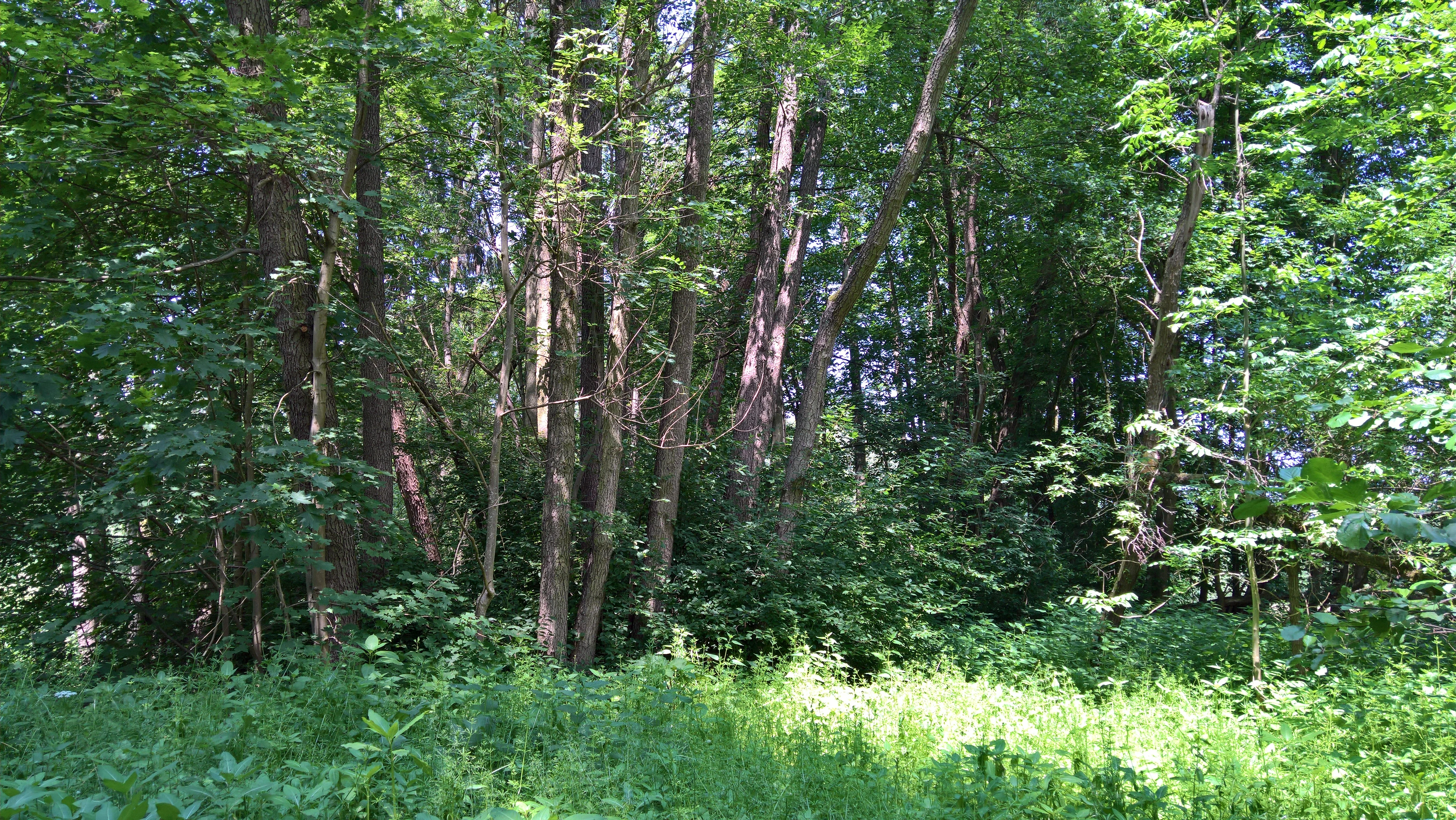
A thick, green forest scene with dense deciduous trees, undergrowth, and filtered sunlight.
A lush, dense section of forest within the Bruch von Bad König und Etzen-Gesäß nature reserve.

Bruch von Bad König und Etzen-Gesäß history and protected-area timeline

The area now known as Bruch von Bad König und Etzen-Gesäß was placed under formal nature protection on 28 July 1980, when it was designated as a Naturschutzgebiet under the Hessian nature conservation framework with the identifier 1437005. The original protection order recognized the area's value as a near-natural section of the Mümling river floodplain.

The reserve's legal basis was updated through a revised ordinance issued on 27 March 2001, which reaffirmed and modernized the protection objectives. The 2001 framework continues to govern management today, including the requirement that grassland within the reserve be maintained through extensive, low-intensity use, without fertilizer or plant protection products.

Beyond this regulatory history, the broader context of the Odenwaldkreis includes a notable concentration of similarly named 'Bruch' reserves, such as the Bruch von Brensbach and the Bruchwiesen von Dorndiel, reflecting a regional tradition of protecting small floodplain and wetland sites scattered along the river valleys of the Odenwald.

Bruch von Bad König und Etzen-Gesäß landscape and geographic character

The landscape of the reserve is defined by the Mümling valley, a low-elevation river corridor cutting through the Buntsandstein-Odenwald. Elevation within the protected area sits between roughly 170 and 177 meters above sea level, making it one of the lower-lying protected sites in the district and quite different in character from the surrounding forested uplands.

The terrain is broadly flat along the river course, shaped by alluvial processes rather than the harder sandstone ridges that frame the valley. Two sub-areas of the reserve follow this corridor: one extending northwest of Bad König's town centre along the Mümling toward Etzen-Gesäß, and another southwest of Etzen-Gesäß itself.

Human infrastructure is closely woven into this small landscape. The Odenwaldbahn railway line cuts across the protected area, the B 45 federal road runs along its eastern edge, and the L 3318 state road lies just to the north. Together, these features illustrate how the reserve has been shaped as a narrow green corridor squeezed between transport routes and settlements, yet still maintaining a continuous sequence of floodplain habitats.

Bruch von Bad König und Etzen-Gesäß ecosystems, habitats, and plant life

Ecologically, the reserve is a classic example of a Central European lowland river floodplain, with a habitat mosaic that is unusually rich for its compact size. The Mümling itself functions as a Fließgewässer, or flowing water habitat, structuring the surrounding communities.

Along the river, patches of Auwald (softwood floodplain forest) and other woody stands reflect the site's history of natural flooding and sediment deposition. These wooded areas are interspersed with open habitats, including species-rich Feuchtwiesen (moist meadows), extensive Röhrichtbestände (reed beds), and Seggenrieder (sedge fen communities). The combination of mature reed beds, sedge fens and wet meadows is characteristic of relatively undisturbed lowland floodplain systems and is rare within the broader Odenwald, which is otherwise dominated by drier forest types.

Grassland within the reserve is managed extensively, without the use of fertilizers or plant protection products, a regime that supports the herb-rich, open character of the meadows and helps prevent succession toward dense scrub or woodland. The continuity between aquatic, semi-aquatic and terrestrial habitats gives the reserve a layered ecological structure valued for both species conservation and ecological connectivity in the region.

Bruch von Bad König und Etzen-Gesäß wildlife and species highlights

The reserve supports a characteristic floodplain fauna, with particular importance for birdlife, amphibians, fish and insects associated with wetland and wet-meadow habitats.

The Mümling itself provides habitat for fish adapted to flowing freshwater conditions, while the mosaic of reed beds, sedge fens and wet meadows offers breeding and foraging opportunities for a range of bird species typical of Central European river valleys. Amphibians benefit from the combination of standing and slowly moving water in reed and sedge habitats, as well as from the moist meadow environments surrounding them.

The herb-rich meadows and structurally diverse margins also host a notable insect fauna, which in turn supports the broader food web of the reserve. While the source material highlights these general groups rather than individual species, it underscores that the site's biodiversity value lies in the integrity of the habitat mosaic as a whole rather than in any single flagship species.

Bruch von Bad König und Etzen-Gesäß conservation status and protection priorities

From a conservation perspective, Bruch von Bad König und Etzen-Gesäß is significant primarily as a protected example of a near-natural river floodplain within the Buntsandstein-Odenwald. Its designation as a Naturschutzgebiet under Hessian law, with IUCN Category IV (Habitat/Species Management Area) status, reflects its role in actively managing habitat for characteristic wetland species.

The reserve's core objective is the preservation of the natural floodplain character of the Mümling valley, including its river course, floodplain forest, wet meadows, reed beds and sedge fens. Maintaining this mosaic against degradation or intensification is the central management goal. Grassland is kept open through extensive use, with fertilizers and plant protection products explicitly prohibited, helping retain the floristic and faunal diversity that depends on low-intensity management.

Within the broader Odenwaldkreis network of protected areas, which includes several similarly small floodplain and wetland reserves, this site contributes to maintaining ecological connectivity along the Mümling and preserving features that are otherwise scarce in the sandstone-dominated Odenwald uplands.

Top sights and standout views in Bruch von Bad König und Etzen-Gesäß

A small but ecologically rich floodplain reserve protecting a section of the Mümling river in the southern Odenwald.

Combines flowing water, softwood floodplain forest, wet meadows, reed beds and sedge fens into a compact habitat mosaic unusual for the surrounding sandstone uplands.

Operates as a Hessian Naturschutzgebiet, with conservation-oriented management that excludes fertilizers and plant protection products on its grasslands.

Functions as one of several small wetland reserves along the Mümling and across the Odenwaldkreis, contributing to regional habitat connectivity.

Monthly climate preview

Long-term monthly temperature averages and precipitation records for Hessen

Bruch von Bad König und Etzen-Gesäß Climate Normals and Temperature Rhythms

Historical climate data for Bruch von Bad König und Etzen-Gesäß records a progression from winter minimums near minus ten degrees to summer maximums exceeding thirty-three degrees. Reviewing the complete twelve-month temperature and precipitation profile provides detailed context for regional environmental patterns.
Annual mean10 °C
0 °C20 °C
Jan
Feb
Mar
Apr
May14°
Jun18°
Jul20°
Aug20°
Sep15°
Oct10°
Nov
Dec
Warmest month
July

20.3 °C

Coolest month
January

0.1 °C

Wettest month
July

2.4 mm/day

Driest month
April

1.5 mm/day

Park location guide

Geography guide, regional context, and park location map for Bruch von Bad König und Etzen-Gesäß

Bruch von Bad König und Etzen-Gesäß park geography, regions, and map view in Germany

Understand where Bruch von Bad König und Etzen-Gesäß sits in Germany through a broader geographic reading of the surrounding landscape, nearby location context, and its mapped position within the national park landscape.

How Bruch von Bad König und Etzen-Gesäß fits into Germany

Germany is a federal republic in Western and Central Europe with a population of over 83 million across sixteen constituent states. It is Europe's largest economy by nominal GDP and a major global exporter and importer. The capital is Berlin, and the country borders Denmark, Poland, Czech Republic, Austria, Switzerland, France, Luxembourg, Belgium, and the Netherlands.

Wider geography shaping Bruch von Bad König und Etzen-Gesäß in Germany

Germany is located in Western and Central Europe, spanning 357,022 km². It borders Denmark to the north, Poland and the Czech Republic to the east, Austria and Switzerland to the south, and France, Luxembourg, Belgium, and the Netherlands to the west. The country has coastlines on the Baltic Sea and North Sea to the north, with the Alps located in the southern region.

Map view of Bruch von Bad König und Etzen-Gesäß

Use this park location map to pinpoint Bruch von Bad König und Etzen-Gesäß in Germany, understand its exact geographic position, and read its mapped placement within the surrounding landscape more clearly.

Pigeon | © OpenStreetMap contributors

Location context for Bruch von Bad König und Etzen-Gesäß

Hessen

Visual exploration of floodplain habitats, wet meadows, and protected river terrain

Bruch von Bad König und Etzen-Gesäß Photos and Landscape Scenery

Visual documentation captures the complex wetland habitats, flowing waterways, and alluvial floodplains defining the nature reserve. Detailed photography illustrates the distinct terrain and ecological character of the protected valley landscape.

A thick, green forest scene with dense deciduous trees, undergrowth, and filtered sunlight.

A bicycle stands at the edge of a paved road, near the entrance to a lush green forest path within the nature reserve.

Park atlas

Discover adjacent nature reserves, river valleys, and connected regional park geography in the Odenwald

Parks Near Bruch von Bad König und Etzen-Gesäß: Explore Surrounding Protected Areas

Browse other protected areas and river valley reserves located near Bruch von Bad König und Etzen-Gesäß across the southern Odenwald. Expanding the geographic comparison reveals how lowland floodplain habitats relate to the wider sandstone uplands of Hesse.
Nature reserveHesse
About 6.1 km away#1 closest

Southwest

Rohrsee von Rehbach Nature Reserve: Protected Wetland Atlas and Regional Geography

Wetland ecosystems in the sandstone Odenwald region of Hesse

Examine the geography of Rohrsee von Rehbach, an IUCN category protected area in southern Hesse. The site features a man-made pond and significant reed habitats that offer a rare wetland contrast to the surrounding sandstone terrain. Our atlas details the reserve's topography, hydrologic features, and its function as a managed refuge for waterbirds in the Odenwald landscape.

Area
0.156 km²
Established
1986
IUCN
IV
Watercolor painting of a wide, low-horizon landscape featuring a line of green trees against a pale pink sky over a pale, sandy foreground.
Nature reserveHessen
About 8.7 km away#2 closest

North

Sandsteinbrüche am Burzelberg bei Frau-Nauses Protected Nature Reserve and Quarry Atlas

Odenwald mountain range, Hessen protected area

Examine the geography of Sandsteinbrüche am Burzelberg bei Frau-Nauses, a protected nature reserve in Hessen. This site features striking Buntsandstein quarry walls and rewilded forest edges, providing a specialized environment for cliff-nesting raptors and documenting local industrial history through its geological formations.

Area
0.195 km²
Established
1994
Relief
Upland
Climate
Temperate
A watercolor illustration of a soft, pastel-colored wetland landscape with trees, grassy banks, and distant hills.
Nature reserveHesse
About 8.8 km away#3 closest

West

Bruch von Brensbach: Mapping the Nature Reserve and Wetland Mosaic in Hesse, Germany

Protected carr woodland and Gersprenz valley stream corridors

Located in the Odenwaldkreis district of Hesse, Bruch von Brensbach acts as a crucial protected wetland corridor. The reserve preserves a rare concentration of alder carr forest and reed beds along the Kilsbach stream, offering a stark geographic contrast to the agricultural fields that characterize the broader Gersprenz valley landscape.

Area
0.055 km²
Established
1983
IUCN
IV
A horizontal watercolor illustration depicting a meandering stream through green valley meadows, flanked by soft foliage and rolling hills in the background.
Nature reserveOdenwaldkreis
About 9.8 km away#4 closest

Southeast

Geierstal von Vielbrunn Nature Reserve: Odenwald Landscape and Geography

Protected brook valley and floodplain ecosystems

Geierstal von Vielbrunn is a distinct nature reserve in Odenwaldkreis, characterized by a narrow valley floor carved by the Ohrenbach stream. The site preserves rare sedge fens, tall herb communities, and black alder galleries that provide essential refuge for regional wildlife. This protected landscape highlights the complex ecological transition between Hessian and Bavarian forest zones in a compact, valley-bottom geography.

Area
0.16 km²
Established
2000
Relief
Upland
Climate
Temperate
A horizontal watercolor illustration of a soft, hazy landscape with rolling hills, meadows, and indistinct patches of vegetation against a light background.
Nature reserveHessen
About 12 km away#5 closest

North

Bruchwiesen von Dorndiel Nature Reserve in Hessen: Protected Landscape and Geography

Wetland habitat and stream valley terrain in the Buntsandstein Odenwald

Bruchwiesen von Dorndiel represents a rare, compact concentration of wetland habitats, including open water, reedbeds, and moisture-gradient meadows. Located in the Amorbach stream corridor, this nature reserve is a key node for local biodiversity and regional landscape preservation within the broader Odenwald mountain range.

Area
0.087 km²
Established
1977
IUCN
IV
Relief
Upland
A soft watercolor illustration depicting a green, hilly landscape with meadows and distant low slopes on a white background.
Nature reserveHesse
About 13 km away#6 closest

Northwest

Forstberg von Ueberau: A Volcanic Nature Reserve and Protected Landscape in Hesse, Germany

Geographic atlas of an extinct volcano and dry grassland refuge.

Forstberg von Ueberau serves as a vital ecological anchor within the Reinheimer Hügelland. This 30-hectare nature reserve preserves an unusual volcanic substrate, featuring a crater-shaped basalt quarry surrounded by seminatural meadows and hedgerows. The site stands as a prime example of habitat management where traditional agricultural practices and biodiversity protection converge to sustain Red List species in a structured, open-country setting.

Area
0.305 km²
Established
1990
IUCN
IV
Watercolor painting of a tranquil pond landscape with soft green reeds, grasses, and low trees under a pale, muted sky.
Nature reserveHesse
About 15 km away#7 closest

Northwest

Reinheimer Teich Nature Reserve: Mapped Wetlands and Biodiversity in Hesse, Germany

A lowland wetland refuge in the Reinheimer Becken

Reinheimer Teich represents a significant nature reserve in the Darmstadt-Dieburg district of Hesse. This protected area features a mosaic of reed beds, wet meadows, and open water channels. It is recognized as one of the final strongholds for the European pond turtle and remains a key node within the Untere Gersprenz river system, demonstrating the vital role of floodplain restoration in local landscape conservation.

Area
0.75 km²
Established
1975
IUCN
IV
Relief
Lowland
A horizontal watercolor illustration of a soft, rolling landscape with a central winding path or stream, green meadows, distant hills, and foreground trees and flowers.
Nature reserveHesse
About 16 km away#8 closest

Southwest

Gras-Ellenbacher Wiesen Nature Reserve: Protected Valley Basin Geography and Map Overview

Wet meadows and seepage habitats within the Odenwald hills

Situated in a gentle hollow near the Dachsberg and Kirchberg ridges, Gras-Ellenbacher Wiesen represents an essential Hessian nature reserve. This overview highlights the interplay between the Ulfenbach stream, drainage infrastructure, and traditional meadow management that defines this distinct sandstone upland protected landscape.

Area
0.241 km²
Established
1981
IUCN
IV
Relief
Upland

Common questions about visiting, size, designation, and location context for Bruch von Bad König und Etzen-Gesäß

Bruch von Bad König und Etzen-Gesäß FAQs for park facts, access, geography, and protected area context

Find quick answers about Bruch von Bad König und Etzen-Gesäß, including protected-area facts, park geography, trail and visitor context, and how the park fits into its surrounding country and regional landscape.
MoriAtlas Explorer

Continue Your Protected Areas Search Across the Global Atlas

Deepen your exploration by continuing the structured search for national parks and protected areas worldwide. Utilize the comprehensive filtering capabilities to compare different conservation landscapes and refine your understanding of global park geography. Discover more about the distribution and characteristics of protected natural areas.

Global natural geography