
Mori Atlas logo
Nature reserveGeierstal von Vielbrunn

A sheltered Odenwald brook valley featuring floodplain meadows and alder galleries

Geierstal von Vielbrunn Nature Reserve: Mapped Protected Landscapes in Odenwaldkreis

(Naturschutzgebiet Geierstal von Vielbrunn)

Geierstal von Vielbrunn represents a critical protected area within the Odenwald region, encompassing a narrow valley corridor along the upper Ohrenbach stream. The landscape is defined by a mosaic of near-natural watercourses, wet meadows, and beech forest ridges that extend toward the Bavarian state border. This site provides vital habitat structure for diverse amphibians and birds within its protected 16-hectare boundary, offering a window into the intimate geography of the northeastern Odenwald.

nature reservevalley landscapebrook valleyfloodplain meadowswet meadowsalder gallery forest
A flat vector illustration showing a mountain valley at sunrise. In the foreground, a path leads to a bridge over a winding river. Mountains with a waterfall rise in the background, framed by dark silhouettes of trees on either side.

Geierstal von Vielbrunn

Nature reserve

Park overview

Structured park overview, official facts, and landscape profile for Geierstal von Vielbrunn

Geierstal von Vielbrunn park facts, protected area profile, and essential visitor context

Review the core facts for Geierstal von Vielbrunn, including designation, size, terrain, visitor scale, habitats, and operating context in one park-focused overview.

About Geierstal von Vielbrunn

Geierstal von Vielbrunn sits at the northeastern edge of the Odenwald, a low mountain range characterized by forested ridges, narrow valleys, and a long history of traditional land use. The reserve is shaped around the upper Ohrenbach, a small, partly meandering stream whose valley floor has retained much of its original meadow character.

The protected area is elongated and narrow, oriented roughly north to south. To the north the reserve is bordered by two fish ponds, while to the south it is bounded by the tributary Vielbrunner Bach entering from the west and by the L3318 road. The southeastern edge of the reserve touches the state border between Hesse and Bavaria, placing the area at an important cross-border ecological interface.

Ecologically, the reserve is significant because it combines several habitat types that rarely survive together in such intact condition. The valley floor is dominated by wet meadows within the floodplain of the Ohrenbach, interspersed with remnants of large sedge fens (Großseggenrieder) and tall herb communities (Hochstaudenfluren). These open wetland habitats are accompanied by mat-grass swards (Borstgrasrasen) on drier margins and by black alder gallery forests (Schwarzerlensaum) along the stream course itself.

The surrounding slopes carry Hainsimsen beech forest, a Luzulo-Fagenion woodland type typical of acidic, nutrient-poor Odenwald soils. This mosaic of wet valley habitats and adjacent beech forest creates a varied small-scale landscape, supporting amphibians that depend on both water and forest, as well as a community of woodland birds. The combination of open brook, alder-lined banks, fen relics, and structurally rich beech forest is what gives Geierstal von Vielbrunn its conservation value, despite its modest overall size.

Quick facts and research context for Geierstal von Vielbrunn

Geierstal von Vielbrunn is a state-designated nature reserve in the Odenwaldkreis of southern Hesse, within the municipal area of Michelstadt. It covers roughly 16 hectares and has been protected since 2000 under the official designation 1437012. The reserve lies in the northeastern Odenwald, just east of the village of Vielbrunn, and follows the upper valley of the Ohrenbach stream near the border with Bavaria.

Protection and recognition

Documented terrestrial boundaries, management scope, and international recognition data

Geierstal von Vielbrunn Protection Status and Formal Conservation Frameworks

Geierstal von Vielbrunn maintains a documented terrestrial protection scope within regional conservation frameworks. Official records organize administrative boundaries and recognition data to establish a factual overview of the protected area.

Protection details

Protection scope
Terrestrial
Transboundary protection
No
Park context

Deeper park guide and search-rich context for Geierstal von Vielbrunn

Geierstal von Vielbrunn history, landscape, wildlife, and travel context

Explore Geierstal von Vielbrunn through its history, landscape character, ecosystems, wildlife, conservation priorities, cultural context, and seasonal travel timing in a structured park guide built for atlas discovery and search intent.

Why Geierstal von Vielbrunn stands out

The reserve is best known for preserving a near-natural Odenwald brook valley with old alder galleries, valley-floor meadows, and remnants of large sedge and tall herb fen communities that have become rare in the region. The adjoining Luzulo-Fagenion beech forest, dominated by Hainsimsen, adds a distinctive woodland component that supports amphibians and forest bird species typically associated with structurally diverse, near-natural Odenwald habitats.
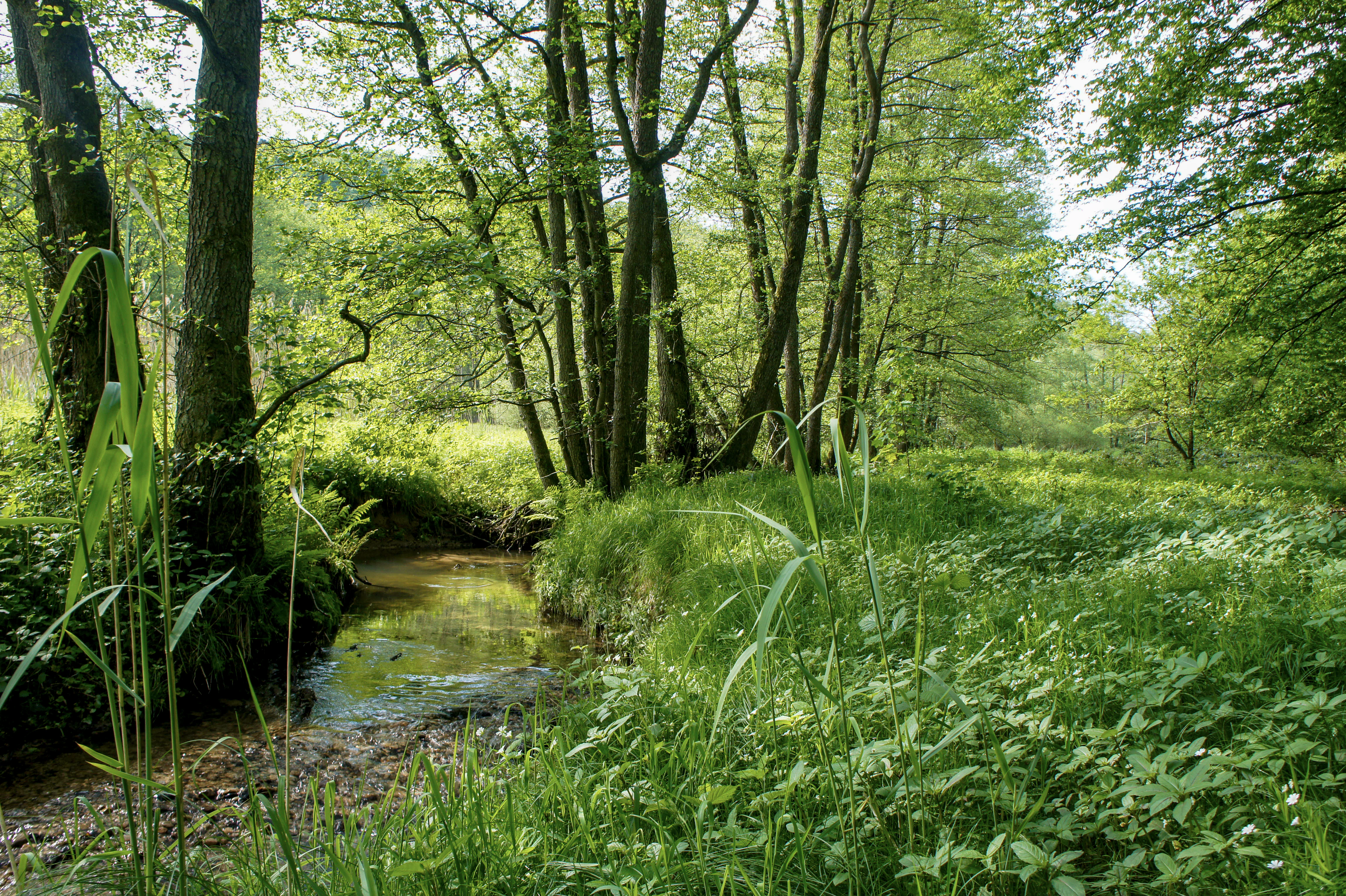
A small, quiet stream flowing through a grassy meadow bordered by a line of deciduous trees in a valley.
The Ohrenbach stream flowing through the lush green valley meadows of the Geierstal nature reserve.

Geierstal von Vielbrunn history and protected-area timeline

The area now known as Geierstal von Vielbrunn has been formally protected as a Naturschutzgebiet since the year 2000, registered under the official identification number 1437012. The designation reflects concern over the long-term preservation of the upper Ohrenbach valley, whose near-natural course, alder-lined banks, and surviving wet meadow and fen fragments had become increasingly rare in the intensively used Odenwald landscape.

Before formal protection, the valley's traditional use as grassland and the slow dynamics of the small stream allowed the persistence of large sedge communities, tall herb stands, and mat-grass swards that are characteristic of older, less-modified valley meadows. These landscape elements, together with the surrounding acid beech forest, ultimately justified inclusion of the area in the list of state-protected nature reserves of Hesse, and the site remains part of the broader series of small valley reserves in the Odenwaldkreis.

Geierstal von Vielbrunn landscape and geographic character

The landscape of Geierstal von Vielbrunn is defined by a narrow, elongated valley running roughly north to south through the northeastern Odenwald. The valley floor is shaped by the upper Ohrenbach, which meanders gently through a soft floodplain flanked by two forested ridges that close in around the brook. The enclosed, valley-in-valley character creates an intimate, sheltered scenery typical of small Odenwald brooks.

Within the protected area, the terrain alternates between low-lying wet meadows along the stream, slightly elevated margins with mat-grass swards, and the steeper forested slopes that rise above the floodplain. Two fish ponds sit at the northern end of the reserve, while the southern end is shaped by the junction of the Vielbrunner Bach with the Ohrenbach, and by the L3318 road that marks a clear landscape boundary. The southeastern edge of the reserve meets the Hessian-Bavarian state border, situating the valley at the transition between two administrative and ecological regions.

Geierstal von Vielbrunn ecosystems, habitats, and plant life

Ecologically, Geierstal von Vielbrunn is a textbook example of a small, near-natural Odenwald brook valley. The floodplain retains extensive meadow communities that interact directly with the stream, while the watercourse itself is bordered by a Schwarzerlensaum, a black alder gallery forest typical of soft, slowly flowing brooks in low mountain ranges.

Scattered through the wet meadows are fragments of Großseggenrieder (large sedge fen) and Hochstaudenfluren (tall herb communities), two habitat types that depend on consistent moisture and minimal disturbance. Where the ground dries slightly, Borstgrasrasen (mat-grass swards) persist, an increasingly rare grassland type in central European low mountain ranges. The slopes above the valley are covered by Hainsimsen-Buchenwald, a Luzulo-Fagenion beech woodland adapted to acidic, relatively nutrient-poor soils.

Together these habitats form a small but ecologically rich mosaic, linking open, species-rich wet meadows and fens with structurally diverse, near-natural beech forest, a combination that gives the reserve disproportionate conservation value relative to its size.

Geierstal von Vielbrunn wildlife and species highlights

The combination of wet valley meadows, alder-lined brook, and adjoining beech forest makes Geierstal von Vielbrunn an important refuge for amphibians. The fish ponds at the northern end and the slow, meandering main stream provide breeding habitat, while the surrounding forest offers shaded terrestrial retreats. The varied habitat structure supports a range of woodland bird species typical of the Odenwald, particularly those associated with near-natural beech-dominated forest and valley-edge transitions. The presence of rare plant communities, particularly the surviving sedge fens and tall herb fringes, also underpins an associated invertebrate fauna of ecological interest.

Geierstal von Vielbrunn conservation status and protection priorities

Designated as a Naturschutzgebiet in 2000 under number 1437012, Geierstal von Vielbrunn is protected specifically to maintain the open character of the valley meadows along the Ohrenbach, to preserve the near-natural brook with its valuable black alder gallery, and to safeguard the remnants of large sedge and tall herb communities together with their accompanying mat-grass swards. The status of the surrounding Hainsimsen beech forest as a valuable habitat for amphibians and forest birds reinforces the importance of protecting both valley floor and slope.

By integrating meadow, fen, brook, alder gallery, and acidic beech forest within a compact area, the reserve represents a high-density conservation target in the Hessian Odenwald, contributing to the broader network of small valley nature reserves (Naturschutzgebiete) in the Odenwaldkreis.

Geierstal von Vielbrunn cultural meaning and human context

The reserve lies in a region of long-standing traditional land use, in which small Odenwald valleys like this one have been used for hay meadows, grazing, and small-scale forestry for centuries. The maintenance of valley meadows and brook-side alder stands reflects this cultural-historical land use pattern, in which regular mowing and low-intensity forest management have helped preserve habitats that have largely disappeared from more heavily farmed lowlands of Hesse.

Top sights and standout views in Geierstal von Vielbrunn

Narow Odenwald brook valley along the upper Ohrenbach, with surviving black alder gallery forest and near-meandering stream course. Rare remnants of large sedge fens and tall herb communities with accompanying mat-grass swards. Surrounding Hainsimsen beech forest providing habitat for a range of amphibians and woodland birds. Compact 16-hectare reserve with cross-border significance along the Hessian-Bavarian state border.

Best time to visit Geierstal von Vielbrunn

Late spring through early summer is generally a good period to experience floodplain meadows in full bloom, when tall herb fringes and meadow vegetation are most expressive and bird activity is high. Early morning visits in spring and early summer provide the best chance to hear woodland bird song and amphibian activity around the ponds and stream. Damp, mild conditions highlight the wet-meadow character of the reserve; in winter the valley reveals the structural contrast between open meadow floor and surrounding beech forest slopes.

Monthly climate preview

Long term monthly averages spanning temperature extremes and precipitation rhythm for Geierstal von Vielbrunn

Geierstal von Vielbrunn Climate Normals, Annual Temperature and Precipitation Patterns

Representative coordinates record long term monthly mean temperatures ranging from negative values up to nearly twenty degrees alongside steady daily precipitation normals. Examining the complete twelve month profile provides deeper insight into measured temperature bounds and annual climate variability.
Annual mean9 °C
0 °C19 °C
Jan
Feb
Mar
Apr
May13°
Jun17°
Jul19°
Aug19°
Sep15°
Oct
Nov
Dec
Warmest month
July

19.5 °C

Coolest month
January

-0.5 °C

Wettest month
July

2.5 mm/day

Driest month
April

1.5 mm/day

Park location guide

Geography guide, regional context, and park location map for Geierstal von Vielbrunn

Geierstal von Vielbrunn park geography, regions, and map view in Germany

Understand where Geierstal von Vielbrunn sits in Germany through a broader geographic reading of the surrounding landscape, nearby location context, and its mapped position within the national park landscape.

How Geierstal von Vielbrunn fits into Germany

Germany is a federal republic in Western and Central Europe with a population of over 83 million across sixteen constituent states. It is Europe's largest economy by nominal GDP and a major global exporter and importer. The capital is Berlin, and the country borders Denmark, Poland, Czech Republic, Austria, Switzerland, France, Luxembourg, Belgium, and the Netherlands.

Wider geography shaping Geierstal von Vielbrunn in Germany

Germany is located in Western and Central Europe, spanning 357,022 km². It borders Denmark to the north, Poland and the Czech Republic to the east, Austria and Switzerland to the south, and France, Luxembourg, Belgium, and the Netherlands to the west. The country has coastlines on the Baltic Sea and North Sea to the north, with the Alps located in the southern region.

Map view of Geierstal von Vielbrunn

Use this park location map to pinpoint Geierstal von Vielbrunn in Germany, understand its exact geographic position, and read its mapped placement within the surrounding landscape more clearly.

Pigeon | © OpenStreetMap contributors

Location context for Geierstal von Vielbrunn

Odenwaldkreis

Visual exploration of Odenwald brook valleys, alder carrs, and wet floodplain meadows.

Geierstal von Vielbrunn Landscape Photos and Protected Area Scenery

Visual documentation of Geierstal von Vielbrunn reveals the intimate terrain of its narrow brook valley, meandering stream courses, and surrounding beech forests. Examining protected area imagery provides clear insight into rare sedge fens, alder galleries, and the natural character of the Odenwald landscape.

A small, quiet stream flowing through a grassy meadow bordered by a line of deciduous trees in a valley.

A triangular green and white German nature reserve sign with an eagle symbol, mounted above an information board, overlooking a snowy meadow and forest background.

Park atlas

Compare nearby brook valleys and protected landscapes across the Odenwald

Parks Near Geierstal von Vielbrunn and Surrounding Regional Protected Areas

Browsing other parks near Geierstal von Vielbrunn reveals connected woodland habitats and protected stream valleys across the surrounding region. Extending the geographic comparison helps trace similar valley floor ecosystems, beech forests, and regional conservation boundaries.
A soft watercolor painting of a wetland landscape with rolling hills in the background, a body of water in the middle, and green grass in the foreground.
Nature reserveHessen
About 9.8 km away#1 closest

Northwest

Bruch von Bad König und Etzen-Gesäß: Nature Reserve and Floodplain Geography

Protected wetland landscapes in the Odenwald region of Hessen

Located along the Mümling river, this nature reserve protects a vital network of moist meadows, reed beds, and softwood forests. The site offers a clear view into the alluvial geography of the Odenwald, showcasing how protected floodplain corridors function within a developed regional landscape.

Area
0.427 km²
Established
1980
IUCN
IV
Relief
Lowland
Nature reserveHesse
About 12 km away#2 closest

West

Rohrsee von Rehbach Nature Reserve: Protected Wetland Atlas and Regional Geography

Wetland ecosystems in the sandstone Odenwald region of Hesse

Examine the geography of Rohrsee von Rehbach, an IUCN category protected area in southern Hesse. The site features a man-made pond and significant reed habitats that offer a rare wetland contrast to the surrounding sandstone terrain. Our atlas details the reserve's topography, hydrologic features, and its function as a managed refuge for waterbirds in the Odenwald landscape.

Area
0.156 km²
Established
1986
IUCN
IV
A horizontal watercolor illustration of a soft, hazy landscape with rolling hills, meadows, and indistinct patches of vegetation against a light background.
Nature reserveHessen
About 17 km away#3 closest

North

Bruchwiesen von Dorndiel Nature Reserve in Hessen: Protected Landscape and Geography

Wetland habitat and stream valley terrain in the Buntsandstein Odenwald

Bruchwiesen von Dorndiel represents a rare, compact concentration of wetland habitats, including open water, reedbeds, and moisture-gradient meadows. Located in the Amorbach stream corridor, this nature reserve is a key node for local biodiversity and regional landscape preservation within the broader Odenwald mountain range.

Area
0.087 km²
Established
1977
IUCN
IV
Relief
Upland
Protected landscapeBaden-Württemberg
About 17 km away#4 closest

East

Freudenberg Protected Landscape: Regional Geography and Main Valley Conservation Mapping

Main-Tauber-Kreis protected land and river valley mosaic.

Freudenberg represents a significant protected landscape in Baden-Württemberg, spanning the confluence of historical settlement patterns and natural river corridors. This area preserves the integrity of the Main Valley through careful stewardship of open fields, wooded ridges, and traditional orchard landscapes that define the local regional character.

Area
17.032 km²
Established
1979
IUCN
V
Scope
Terrestrial
Watercolor painting of a wide, low-horizon landscape featuring a line of green trees against a pale pink sky over a pale, sandy foreground.
Nature reserveHessen
About 17 km away#5 closest

Northwest

Sandsteinbrüche am Burzelberg bei Frau-Nauses Protected Nature Reserve and Quarry Atlas

Odenwald mountain range, Hessen protected area

Examine the geography of Sandsteinbrüche am Burzelberg bei Frau-Nauses, a protected nature reserve in Hessen. This site features striking Buntsandstein quarry walls and rewilded forest edges, providing a specialized environment for cliff-nesting raptors and documenting local industrial history through its geological formations.

Area
0.195 km²
Established
1994
Relief
Upland
Climate
Temperate
A watercolor illustration of a soft, pastel-colored wetland landscape with trees, grassy banks, and distant hills.
Nature reserveHesse
About 18 km away#6 closest

West

Bruch von Brensbach: Mapping the Nature Reserve and Wetland Mosaic in Hesse, Germany

Protected carr woodland and Gersprenz valley stream corridors

Located in the Odenwaldkreis district of Hesse, Bruch von Brensbach acts as a crucial protected wetland corridor. The reserve preserves a rare concentration of alder carr forest and reed beds along the Kilsbach stream, offering a stark geographic contrast to the agricultural fields that characterize the broader Gersprenz valley landscape.

Area
0.055 km²
Established
1983
IUCN
IV
A horizontal watercolor illustration of a soft, rolling landscape with a central winding path or stream, green meadows, distant hills, and foreground trees and flowers.
Nature reserveHesse
About 20 km away#7 closest

Southwest

Gras-Ellenbacher Wiesen Nature Reserve: Protected Valley Basin Geography and Map Overview

Wet meadows and seepage habitats within the Odenwald hills

Situated in a gentle hollow near the Dachsberg and Kirchberg ridges, Gras-Ellenbacher Wiesen represents an essential Hessian nature reserve. This overview highlights the interplay between the Ulfenbach stream, drainage infrastructure, and traditional meadow management that defines this distinct sandstone upland protected landscape.

Area
0.241 km²
Established
1981
IUCN
IV
Relief
Upland
A wide watercolor painting showing rolling green hills and trees with pale pink and yellow hues across a valley landscape.
Nature reserveHessen
About 21 km away#8 closest

Southwest

Rotes Wasser von Olfen Nature Reserve: Protected Wetland and Odenwald Geography

A unique bog and iron-rich stream landscape in Hessen, Germany.

Rotes Wasser von Olfen preserves a rare, small-scale mosaic of transitional bog and wet meadow vegetation within the Odenwald range. This protected site features reddish, iron-rich seepage waters and provides essential habitat for specialized flora and dragonfly populations amidst a surrounding forested mountain landscape.

Area
0.121 km²
Established
1980
IUCN
IV
Relief
Upland

Common questions about visiting, size, designation, and location context for Geierstal von Vielbrunn

Geierstal von Vielbrunn FAQs for park facts, access, geography, and protected area context

Find quick answers about Geierstal von Vielbrunn, including protected-area facts, park geography, trail and visitor context, and how the park fits into its surrounding country and regional landscape.
MoriAtlas Explorer

Continue Your Protected Areas Search Across the Global Atlas

Deepen your exploration by continuing the structured search for national parks and protected areas worldwide. Utilize the comprehensive filtering capabilities to compare different conservation landscapes and refine your understanding of global park geography. Discover more about the distribution and characteristics of protected natural areas.

Global natural geography