Mori Atlas logo
Protected landscapeButte Valley National Grassland

A rare high-desert sagebrush steppe basin framed by Cascade Range volcanic terrain

Butte Valley National Grassland: Mapped Geography and Protected Landscape Context

Butte Valley National Grassland represents California's sole designated national grassland, preserving an expansive high-desert habitat within the Klamath River basin. The protected landscape spans over 4,200 feet in elevation, featuring a distinct dry lakebed and sandy soils that contrast with the surrounding mountain ranges. Viewers can examine the geographical interplay between these open bunch-grass plains and the prominent, snow-covered volcanic peaks of Mount Shasta that dominate the skyline.

national grasslandsagebrush steppehigh desertgrassland habitatbirdwatchingraptor habitat

Butte Valley National Grassland

Protected landscape

Park overview

Structured park overview, official facts, and landscape profile for Butte Valley National Grassland

Butte Valley National Grassland park facts, protected area profile, and essential visitor context

Review the core facts for Butte Valley National Grassland, including designation, size, terrain, visitor scale, habitats, and operating context in one park-focused overview.

About Butte Valley National Grassland

Butte Valley National Grassland occupies a portion of the Klamath River basin in far northern California, just south of the Oregon border. Though California is usually associated with redwoods, Sierra Nevada alpine country, and Mediterranean coastal environments, this grassland offers a different ecological face of the state: a wide, dry, sagebrush-dominated flat in the rain shadow of the Cascades. The result is a landscape that feels closer to the Great Basin than to anything else in California.

What the grassland protects is a fragment of native sagebrush steppe, the kind of open habitat that has been heavily reduced across the West by conversion to cropland, invasive grasses, and overgrazing. The terrain itself is mostly level, with sandy soils and a dry lakebed, but the setting is dramatic: the surrounding Cascades and the snow-capped cone of Mount Shasta rise prominently to the south, giving visitors a constant visual reminder that the flat valley they stand in sits within a much larger volcanic and montane region.

The grassland is unusual administratively because it is the only National Grassland in California and the only one in the U.S. Forest Service’s Pacific Southwest Region. It is managed together with the neighboring Klamath National Forest, and its scale, setting, and habitat mix make it a distinctive addition to the national grassland system. Although smaller than many Western protected areas, its ecological role is meaningful because true sagebrush-steppe habitat in California is extremely limited.

For visitors, the grassland delivers an experience that contrasts with the forested and alpine parks for which California is usually known. Instead of dense woods and steep summits, it offers wide horizons, quiet sage flats, seasonal wildflowers, and one of the best birding opportunities in the region. The combination of accessibility (right along U.S. Highway 97) and unusual habitat makes it a notable stop for travelers exploring the far northern edge of the state.

Quick facts and research context for Butte Valley National Grassland

Butte Valley National Grassland sits on roughly 18,425 acres of flat, sandy terrain in the northernmost part of California, in Siskiyou County near the Oregon state line. It sits at about 4,200 feet in elevation and receives around 12 inches of precipitation a year, giving it a dry, high-desert character unusual for California.

The area is the only National Grassland in the state and was the twentieth such unit designated in the United States when it was dedicated in July 1991. It is managed by the U.S. Forest Service together with the adjacent Klamath National Forest, with administrative offices in Macdoel, California.

Protection and recognition

Documented terrestrial protection scope and 1991 establishment records

Butte Valley National Grassland Protection Status and Designation History

Butte Valley National Grassland maintains a documented terrestrial protection status established in 1991 without international recognition listings. Official records capture baseline management scope and designation history for structured geographic analysis.

Protection details

Protection scope
Terrestrial
Designated year
1991
Transboundary protection
No
Park context

Deeper park guide and search-rich context for Butte Valley National Grassland

Butte Valley National Grassland history, landscape, wildlife, and travel context

Explore Butte Valley National Grassland through its history, landscape character, ecosystems, wildlife, conservation priorities, cultural context, and seasonal travel timing in a structured park guide built for atlas discovery and search intent.

Why Butte Valley National Grassland stands out

Butte Valley National Grassland is best known for being California’s sole National Grassland and for preserving a rare patch of high-desert sagebrush steppe in a region otherwise dominated by mountains and forests. Its sweeping views toward Mount Shasta and the Cascade Range set it apart visually, while its open bunch-grass and sagebrush habitat supports birdlife typically associated with the Great Basin or interior West rather than with most of California.
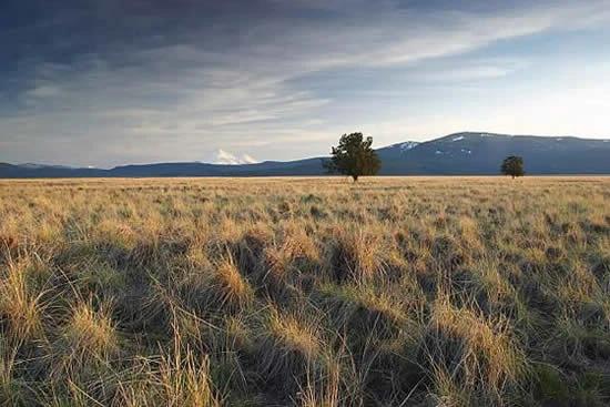
A wide, golden grassland under a moody, partly cloudy sky, with two solitary trees and mountain ranges in the distance.
Golden grasses and lone trees across the expansive landscape of Butte Valley National Grassland.

Butte Valley National Grassland history and protected-area timeline

The Butte Valley area was settled in the late nineteenth century, when homesteaders arrived under the Homestead Act and reshaped the land. They dug ditches, drained the wet flats, plowed the soils, and brought in livestock. This rapid conversion led to declining productivity, and the situation worsened sharply during the severe drought of the 1930s, when wind erosion and overgrazing stripped productivity from much of the area.

Responding to the damage, the U.S. government acquired what were then considered submarginal lands in 1937 and turned them over to the Soil Conservation Service, the predecessor of today's Natural Resources Conservation Service. The agency worked to stabilize the landscape by planting more than 4,000 acres of crested wheatgrass, an introduced species chosen for its ability to hold soil and restore cover on degraded rangeland. During the 1940s a portion of the area was also used as a military bombing range, adding another layer to its twentieth-century land-use history.

Grazing continued on the land throughout the mid-twentieth century even as rehabilitation efforts progressed. The area was eventually protected as a National Grassland in July 1991, becoming the twentieth such unit in the national system and ending a long transition from homesteaded farmland and degraded range to formally conserved habitat. It is now administered by the U.S. Forest Service together with the surrounding Klamath National Forest.

Butte Valley National Grassland landscape and geographic character

The grassland occupies a broad, flat basin in the Klamath River drainage, centered on sandy soils and a dry lakebed that give the area its open, expansive feel. Elevations run around 4,200 feet, placing the valley firmly in a high-desert setting despite being well within California. Annual precipitation is low, near 12 inches, supporting dry-adapted vegetation rather than woodlands or wet meadows.

The most striking visual feature of the grassland is not the flats themselves but the mountains that frame them. The Cascade Range rises on multiple sides, and the snow-covered peak of Mount Shasta dominates the southern skyline. These views, set against the wide sage-bottomed valley, are one of the area's defining landscape qualities and a reminder of how the flatlands fit into the broader volcanic terrain of northern California and southern Oregon.

Butte Valley National Grassland ecosystems, habitats, and plant life

The ecological character of Butte Valley is defined by sagebrush steppe, one of the most threatened habitat types in the western United States. The vegetation is a mix of open big sagebrush, rabbitbrush, juniper, and remnant stands of native bunch grasses, with crested wheatgrass stands planted during the mid-twentieth century conservation effort also still present in some areas. Together these plant communities form an open, dry-adapted ecosystem framed by montane surroundings.

Because the habitat is relatively open and dry, it supports a distinctive mix of Great Basin-style wildlife rather than the forested and montane species typical of most of California. Rodent populations drive the predator community, and the vegetation structure provides nesting and foraging opportunities for raptors and ground-nesting songbirds. The combination of native shrubs and bunch grasses, sandy soils, low precipitation, and isolation from major development makes the area a small but ecologically significant refuge for sagebrush-country biodiversity.

Butte Valley National Grassland wildlife and species highlights

Wildlife in Butte Valley National Grassland is shaped by its open sagebrush habitat and the rodent populations that thrive there. The area is notable among California protected sites for its birdlife, and bird watching is one of the main recreational activities. Seasonal visitors include sage thrashers and Brewer's sparrows, which are present in spring, summer, and fall, while resident songbirds include horned larks and lark sparrows.

The grassland supports an unusually strong raptor community. Nesting species include golden eagles, prairie falcons, red-tailed hawks, and Swainson's hawks, all drawn by the abundance of small mammals in the open country. Ferruginous hawks, a species of conservation concern across the West, have also nested successfully in the area in recent years. The predator-prey balance between rodents and raptors is the central wildlife story of the grassland, and birdwatching visitors have a realistic chance of seeing several of these larger raptor species in a single visit.

Butte Valley National Grassland conservation status and protection priorities

Butte Valley National Grassland matters to conservation because it preserves a functioning example of sagebrush steppe habitat in a region where this ecosystem has been heavily altered. Native sagebrush communities have declined dramatically across the West due to agriculture, invasive grasses, wildfire, and historic overgrazing, and true sagebrush country is exceptionally rare in California. The grassland's protected status helps ensure that this habitat, along with its associated native bunch grasses and shrub structure, remains intact rather than continuing the pattern of conversion seen elsewhere in the region.

The site also plays a role in conserving sagebrush-associated bird and mammal species, including several raptors and ground-nesting songbirds that depend on open, dry landscapes. The 1991 designation as a National Grassland protected lands that had already been shaped by earlier conservation work, including the large-scale planting of crested wheatgrass in the late 1930s and 1940s to stabilize soil after the Dust Bowl era. As California's only National Grassland, the site fills a unique niche in the state's protected-area network, complementing the forested and alpine lands managed by neighboring national forests.

Butte Valley National Grassland cultural meaning and human context

The cultural history of Butte Valley is tied to its use as agricultural and grazing land in the late nineteenth and twentieth centuries. Homesteaders reshaped the original wetland and sage flats into plowed farmland and pasture, and the small communities of Dorris and Macdoel grew up along the same corridor, U.S. Highway 97, that today defines access to the grassland. Later, the land served military and conservation purposes, first as a wartime bombing range and later as a soil stabilization project under the Soil Conservation Service. These layered uses give the grassland a working-landscape heritage rather than a pristine-wilderness one, and the surrounding towns remain the human anchors for the area.

Top sights and standout views in Butte Valley National Grassland

Butte Valley's standout features are its open sagebrush flats, its sweeping views toward Mount Shasta and the Cascades, and its unusual status as California's only National Grassland. Birdwatching is a defining activity, with sage thrashers, Brewer's sparrows, and several nesting raptors including golden eagles, prairie falcons, and ferruginous hawks. The unusual combination of dry, sandy lakebed terrain and surrounding volcanic mountains gives the grassland a distinct, memorable character within California's protected-area landscape.

Best time to visit Butte Valley National Grassland

Spring and fall tend to be the most rewarding times to experience Butte Valley National Grassland. In spring, the cooler conditions bring active birdlife, including migrating and nesting sage thrashers and Brewer's sparrows, and wildflower blooms can liven the sage flats. Summer is hotter and drier, but it is also when raptors are most active around nesting sites. Fall brings cooler temperatures and continued raptor presence, while winter can be cold and snowy at this elevation, with occasional road conditions that affect access along U.S. Highway 97.

Monthly climate preview

Long term monthly averages for temperature and precipitation rhythm

Butte Valley National Grassland Climate Normals and Temperature Patterns

Representative coordinate records show measured monthly temperature variations and precipitation distribution across the protected landscape. Detailed historical climate normals provide structured baseline data for evaluating regional environmental conditions.
Annual mean8 °C
-1 °C20 °C
Jan-1°
Feb
Mar
Apr
May10°
Jun15°
Jul20°
Aug19°
Sep15°
Oct
Nov
Dec-1°
Warmest month
July

20.1 °C

Coolest month
December

-1.4 °C

Wettest month
December

3.3 mm/day

Driest month
July

0.3 mm/day

Park location guide

Geography guide, regional context, and park location map for Butte Valley National Grassland

Butte Valley National Grassland park geography, regions, and map view in United States of America

Understand where Butte Valley National Grassland sits in United States of America through a broader geographic reading of the surrounding landscape, nearby location context, and its mapped position within the national park landscape.

How Butte Valley National Grassland fits into United States of America

The United States of America is a federal presidential republic and one of the world's largest countries by area and population. It consists of 50 states across a vast territory spanning multiple time zones, with its capital in Washington, D.C. and largest city in New York City. The nation has a diverse economy, influential political system, and significant cultural and military presence globally.

Wider geography shaping Butte Valley National Grassland in United States of America

The United States occupies a vast territory in North America, bordered by Canada to the north and Mexico to the south. The 48 contiguous states stretch from the Atlantic to the Pacific Ocean, while Alaska occupies the northwestern region and Hawaii is an archipelago in the Pacific. The country encompasses diverse terrain including the Rocky Mountains, Appalachian Mountains, Great Plains, and extensive river systems.

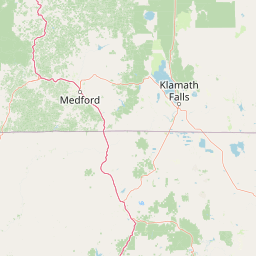
Map view of Butte Valley National Grassland

Use this park location map to pinpoint Butte Valley National Grassland in United States of America, understand its exact geographic position, and read its mapped placement within the surrounding landscape more clearly.

Pigeon | © OpenStreetMap contributors

Location context for Butte Valley National Grassland

CaliforniaSiskiyou County
Recorded earthquake history

View Documented Seismic Events near Butte Valley National Grassland

Navigate through a collection of historical earthquake records associated with Butte Valley National Grassland. MoriAtlas organizes these events by magnitude and proximity to assist in researching the seismic history of this Northern California protected landscape.

Butte Valley National Grassland Earthquake History

Catalogued events

132 events

Strongest magnitude

Magnitude 6

Most recent event

Aug 7, 2008

This history includes earthquakes recorded inside the park or within 50 km of its borders

Explore protected area views, sagebrush steppe terrain, and volcanic mountain backdrops across the high desert.

Butte Valley National Grassland Photos and Scenery: Visualizing California's High Desert Landscape

Visual documentation reveals the expansive sagebrush flats, dry lakebed terrain, and bunch-grass habitats defining California's sole national grassland. Examining these protected area views provides deeper context on the volcanic basin geography and mountain-framed scenery of the Klamath region.

A wide, golden grassland under a moody, partly cloudy sky, with two solitary trees and mountain ranges in the distance.

Park atlas

Compare adjacent volcanic terrain, high desert habitats, and regional reserves

Parks Near Butte Valley National Grassland And Surrounding Protected Areas

Browsing other protected areas near Butte Valley National Grassland reveals the diverse high desert terrain and volcanic landscapes spanning northern California. Expanding the geographic scope helps connect isolated grassland habitats to the broader regional ecosystem and mountain ranges.
Protected landscapeCalifornia
18 km away#1 closest

Southeast

Modoc National Forest: Protected Landscape and Warner Mountains Geography

High desert volcanic terrain in northeastern California

Modoc National Forest encompasses a massive expanse of volcanic plateaus and rugged mountain ridges in the northeastern corner of California. This protected area offers significant geographic variety, transitioning from arid sagebrush basins to lush, high-elevation conifer forests. It serves as a vital natural landscape, home to the South Warner Wilderness and large stands of old-growth timber, reflecting the unique geologic history of the regional lava flows.

Area
6,695.09 km²
Established
1904
Relief
Mountain
Access
Moderate access
A soft watercolor painting depicting a serene landscape with gentle green hills, a small forest, and a calm lake at sunrise or sunset.
Protected landscapeCalifornia
33 km away#2 closest

Southwest

Shasta, Trinity National Forest: Mapping the Protected Landscapes of Northern California

Volcanic peaks, expansive reservoirs, and rugged mountain wilderness

Spanning over two million acres, Shasta, Trinity National Forest represents a major protected landscape in Northern California. The geography includes the iconic Mount Shasta volcano and the complex shoreline of Shasta Lake, while hosting expansive wilderness areas and diverse terrain ranging from oak-forested foothills to alpine meadows.

Area
8,942.87 km²
Established
1954
Relief
Mountain
Climate
Temperate
An artistic watercolor illustration showing a line of green evergreen trees in the foreground with hazy, distant mountains in the background against a light, neutral sky.
Protected landscapeOregon
39 km away#3 closest

West

Rogue River, Siskiyou National Forest: Mapped Geography and Protected Area Overview

Tracing volcanic peaks and river-carved mountain terrain in Oregon

Spanning nearly 7,300 square kilometers, the Rogue River, Siskiyou National Forest acts as a crucial ecological anchor in the Pacific Northwest. This overview details its unique mountain geography, the extensive wilderness tracts within its boundaries, and the river systems that define its mountainous character.

Area
6,973.46 km²
Established
2004
Visitors
915K annual
Relief
Mountain
Wildlife reserveOregon
39 km away#4 closest

North

Mountain Lakes Wilderness: Geographic Atlas of Oregon's Glacial Volcanic Reserve

Mapping the volcanic cirques and square boundaries of the southern Cascades.

Mountain Lakes Wilderness serves as a primary geographic anchor in the southern Cascades, where shield volcanoes meet glacially carved basins. This protected area contains over twenty lakes situated in high-altitude cirques near the summits of volcanic peaks like Aspen Butte. The area is defined by its distinctive square survey-township boundary, providing a clear footprint of wilderness conservation within the larger Fremont-Winema National Forest terrain.

Area
93 km²
Established
1964
IUCN
Ib
Relief
Mountain
A soft watercolor illustration depicting a series of distant mountain ranges behind a line of evergreen trees against a white background.
Wildlife reserveCalifornia
40 km away#5 closest

South

Mount Shasta Wilderness: A Geographic Profile of California Volcanic and Alpine Landscapes

Mapping protected volcanic peaks and glacial ecosystems

Deeply explore the protected geography of Mount Shasta Wilderness, a 38,200-acre reserve in Northern California. This record details the park's stratovolcano foundations, glacial terrain, and forested corridors, offering a clear view of the complex landforms and boundary systems that define this significant high-elevation protected area.

Area
155 km²
Established
1984
IUCN
Ib
Relief
Mountain
A wide watercolor illustration showing a calm body of water surrounded by green hills, conifer trees, and reeds in the foreground.
Protected landscapeCalifornia
63 km away#6 closest

Southeast

Lassen National Forest: Mapped Geography and Protected Landscapes of Northern California

Volcanic terrain and expansive old growth ecosystems

Lassen National Forest represents a vast protected landscape in Northern California, defined by its severe volcanic geology and resilient conifer forests. This atlas entry provides essential geographic context regarding the forest boundaries, the volcanic rim of Mount Tehama, and the intricate river systems shaping the region. Explore the terrain, from accessible lava tubes to the wilderness areas preserved within this significant mountain corridor.

Area
4,331.53 km²
Established
1905
Relief
Mountain
Climate
Temperate
Protected landscapeCalifornia
88 km away#7 closest

Southwest

Marble Mountain Wilderness: Exploring Protected Mountain Landscapes in Northern California

Klamath Mountains Wilderness and Alpine Geography

Spanning hundreds of thousands of acres, Marble Mountain Wilderness offers a dense concentration of subalpine fir, deep glacial lakes, and steep drainage basins. This northern California protected landscape provides an atlas of rugged ridges and marble-toned peaks that represent one of the most ecologically diverse backcountry areas in the region.

Area
978.3 km²
Established
1964
IUCN
Ib
Relief
Mountain
National parkOregon
91 km away#8 closest

North

Crater Lake National Park: Oregon National Park Atlas of Volcanic Landscapes

Explore mapped boundaries and unique caldera geography.

Crater Lake National Park represents a significant protected area within Oregon, defined by the dramatic volcanic caldera it contains. This national park is celebrated for its exceptionally deep, clear blue lake, formed by the collapse of Mount Mazama, offering a unique subject for geographic and landscape study. Users can explore its mapped boundaries and understand its position within the broader atlas of protected lands and mountainous terrain of the Cascade Range.

Area
741.48 km²
Established
1902
IUCN
II
Visitors
527K annual

Common questions about visiting, size, designation, and location context for Butte Valley National Grassland

Butte Valley National Grassland FAQs for park facts, access, geography, and protected area context

Find quick answers about Butte Valley National Grassland, including protected-area facts, park geography, trail and visitor context, and how the park fits into its surrounding country and regional landscape.
MoriAtlas Explorer

Continue Your Protected Areas Search Across the Global Atlas

Deepen your exploration by continuing the structured search for national parks and protected areas worldwide. Utilize the comprehensive filtering capabilities to compare different conservation landscapes and refine your understanding of global park geography. Discover more about the distribution and characteristics of protected natural areas.

Global natural geography