

Mori Atlas logo
National parkChyulu Hills National Park

Discover the mapped boundaries and regional context of this significant national park in Kenya.

Chyulu Hills National Park: Kenya's Protected Landscape and Geographic Atlas

Chyulu Hills National Park represents a distinct protected landscape within Kenya's diverse geography. This page serves as your gateway to understanding its precise location, mapped boundaries, and its role as a national park within the broader atlas of East Africa. Explore the geographic identity of this protected area and its place in the natural terrain of Kenya.

volcanic landscapeshighland forestsKenya national parkswatershed protectiongeological heritageEast Africa conservation

Chyulu Hills National Park

National park

Park overview

Structured park overview, official facts, and landscape profile for Chyulu Hills National Park

Chyulu Hills National Park park facts, protected area profile, and essential visitor context

Review the core facts for Chyulu Hills National Park, including designation, size, terrain, visitor scale, habitats, and operating context in one park-focused overview.

About Chyulu Hills National Park

Chyulu Hills National Park protects a distinctive volcanic mountain landscape in southeastern Kenya. The Chyulu Hills themselves are relatively young volcanic formations, part of a chain of volcanoes and volcanic fields that extends along the eastern margin of the Great Rift Valley. The protected area encompasses the higher reaches of this volcanic complex, preserving not only the geological features but also the watershed and ecological functions that the hills provide for the surrounding semi-arid region. The park lies adjacent to the Tsavo ecosystem, forming an important ecological buffer and corridor for wildlife moving between different habitat zones. While the park has historically received less visitor attention than the famous Tsavo parks to the east, it offers a uniquely different landscape characterized by volcanic rock formations, forest-clothed slopes, and the stark contrast between the rugged highlands and the dusty savanna plains below.

Quick facts and research context for Chyulu Hills National Park

Chyulu Hills National Park is located in Kajiado and Makueni counties in southeastern Kenya, covering the volcanic Chyulu Hills range. The area is characterized by young volcanic formations including cinder cones, lava flows, and crater remnants. The hills rise abruptly from the surrounding plains, reaching elevations over 2,000 meters. The park provides critical watershed functions for local communities and supports biodiversity corridors linking lowland and highland ecosystems.

Protection and recognition

Examining the official terrestrial designation and management scope within the regional landscape

Chyulu Hills National Park Protection Status and Conservation Designation

Exploring the terrestrial protection status of Chyulu Hills National Park reveals its official designation history and established conservation framework. Verifying these management records and documented boundaries provides essential context for understanding the regional geography of this protected wilderness.

Protection details

Protection scope
Terrestrial
Park context

Deeper park guide and search-rich context for Chyulu Hills National Park

Chyulu Hills National Park history, landscape, wildlife, and travel context

Explore Chyulu Hills National Park through its history, landscape character, ecosystems, wildlife, conservation priorities, cultural context, and seasonal travel timing in a structured park guide built for atlas discovery and search intent.

Why Chyulu Hills National Park stands out

Chyulu Hills National Park is best known for its dramatic volcanic landscape of craggy basalt peaks, ancient lava flows, and the impressive Shetani lava flow. The hills contain numerous volcanic caves and tunnels formed by ancient eruptions, some of which contain archaeological significance. The park's isolated highland forests host populations of endemic birds and small mammals, while the contrasting ecosystems from savanna plains to volcanic highlands create a visually striking and ecologically diverse protected area.

Chyulu Hills National Park history and protected-area timeline

Chyulu Hills National Park was established as part of Kenya's national park system to protect the volcanic hills and their ecological functions. The area was originally designated as forest reserve before gaining national park status, reflecting the importance of the watershed and the unique highland habitats. The park's establishment also aimed to provide ecological connectivity with the broader Tsavo conservation area. The volcanic landscape holds archaeological significance, with cave systems having yielded evidence of early human occupation in the region.

Chyulu Hills National Park landscape and geographic character

The Chyulu Hills rise dramatically from the surrounding East African savanna, forming a roughly 100-kilometer-long volcanic mountain range. The landscape is characterized by young basaltic volcanic formations including cinder cones, crater remnants, and extensive lava flows. The most notable feature is the Shetani lava flow, a stark black expanse of volcanic rock that contrasts sharply with the surrounding golden grasslands. The hills reach elevations exceeding 2,000 meters, with the highest peaks supporting montane forest vegetation. Between the volcanic ridges, ancient river valleys and cave systems provide additional topographic variety. The visual contrast between the dark volcanic peaks and the lighter savanna plains creates a striking landscape of considerable aesthetic value.

Chyulu Hills National Park ecosystems, habitats, and plant life

The Chyulu Hills support a range of habitats that contrast sharply with the surrounding lowland environments. The higher elevations hold patches of montane forest dominated by juniper and olive species, while the middle slopes feature dense bushland and thicket. The lava flow areas support specialized pioneer vegetation adapted to the harsh volcanic substrate. These varied habitats create an ecological island effect, with species adapted to higher elevations potentially showing isolation from lowland populations. The park serves as an important watershed, with numerous springs and streams originating in the hills and flowing outward to support communities and wildlife in the surrounding plains.

Chyulu Hills National Park wildlife and species highlights

The wildlife of Chyulu Hills reflects the transitional nature of the ecosystem, with species from both highland and savanna environments present. The park supports populations of elephants that use the hills as a dry-season refuge, as well as buffalo, giraffes, and various antelope species. The forest patches host diverse birdlife including turacos, hornbills, and sunbirds. The volcanic caves provide roosting sites for various bat species. The relatively intact nature of the habitat corridor allows for wildlife movement between the hills and the broader Tsavo ecosystem.

Chyulu Hills National Park conservation status and protection priorities

Chyulu Hills National Park plays an important conservation role in southeastern Kenya by preserving a unique volcanic highland ecosystem that differs significantly from the savanna habitats typical of the region. The protected area maintains ecological connectivity between higher elevation forests and lowland ecosystems, supporting biodiversity and enabling wildlife movement. The watershed function of the hills provides critical water resources for both wildlife and local pastoralist communities. The park also contributes to the broader conservation framework of the greater Tsavo region, adding landscape diversity and ecological resilience to the protected area network.

Chyulu Hills National Park cultural meaning and human context

The Chyulu Hills and surrounding plains are traditionally inhabited by Maasai pastoralist communities whose livestock grazing practices have shaped the landscape over centuries. The volcanic hills hold cultural significance for local communities, and the cave systems have archaeological importance indicating long human occupation of the area. The relationship between traditional pastoralist land use and conservation objectives represents an important aspect of the park's management context.

Top sights and standout views in Chyulu Hills National Park

The Shetani lava flow stands as the park's most dramatic geological feature, a vast black volcanic expanse that is one of the most recent lava flows in the region. The volcanic cave systems offer exploration opportunities and provide important archaeological context. The views from the hilltops across the contrasting savanna plains below are particularly striking. The park provides a quieter, less-visited alternative to the major Tsavo parks while offering a distinctly different landscape of volcanic highlands.

Best time to visit Chyulu Hills National Park

The best time to visit Chyulu Hills National Park is during the dry seasons from June to October and January to February, when wildlife viewing is most reliable and access to the park is easier. The wet seasons from March to May and November to December can make some roads impassable and wildlife more dispersed, though the landscapes are greener and birdlife is more active. The cooler highland temperatures provide a pleasant contrast to the warmer lowland areas.

Monthly climate preview

Measured monthly temperature ranges and precipitation rhythm across the park landscape

Chyulu Hills National Park Climate Normals and Long Term Weather Patterns

Chyulu Hills National Park records long-term monthly mean temperatures spanning from 21.96 degrees Celsius to 25.53 degrees Celsius alongside distinct precipitation variations across the representative coordinate. Analyzing the complete twelve-month climatology profile provides deeper insight into measured baseline temperatures and historical precipitation patterns.
Annual mean24 °C
22 °C26 °C
Jan24°
Feb25°
Mar26°
Apr25°
May23°
Jun22°
Jul22°
Aug22°
Sep24°
Oct24°
Nov24°
Dec24°
Warmest month
March

25.5 °C

Coolest month
July

22 °C

Wettest month
November

4.3 mm/day

Driest month
July

0.3 mm/day

Park location guide

Geography guide, regional context, and park location map for Chyulu Hills National Park

Chyulu Hills National Park park geography, regions, and map view in Kenya

Understand where Chyulu Hills National Park sits in Kenya through a broader geographic reading of the surrounding landscape, nearby location context, and its mapped position within the national park landscape.

How Chyulu Hills National Park fits into Kenya

Kenya is a presidential republic in East Africa and the seventh-most populous country on the continent. Its capital is Nairobi, and it borders five countries and the Indian Ocean. The country features significant geographic diversity including Mount Kenya, the Rift Valley, and coastal regions.

Wider geography shaping Chyulu Hills National Park in Kenya

Kenya is located in East Africa, bordering South Sudan to the northwest, Ethiopia to the north, Somalia to the east, Tanzania to the southwest, and Uganda and Lake Victoria to the west. The southeastern border meets the Indian Ocean. The geography includes the Rift Valley highlands with Mount Kenya, coastal plains, and northern arid regions.

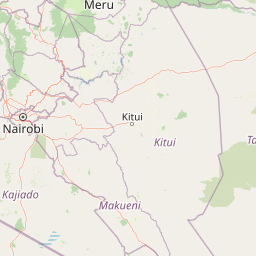
Map view of Chyulu Hills National Park

Use this park location map to pinpoint Chyulu Hills National Park in Kenya, understand its exact geographic position, and read its mapped placement within the surrounding landscape more clearly.

Pigeon | © OpenStreetMap contributors
Park atlas

Trace the diverse geographic spread and connected protected landscapes surrounding Chyulu Hills National Park

Explore Nearby National Parks and Protected Areas Around Chyulu Hills National Park

After exploring Chyulu Hills National Park's unique volcanic terrain, compare adjacent national parks and protected areas to understand the broader East African conservation landscape. Browse nearby park geography, trace regional protected-area connections, and discover how diverse ecosystems link, from dramatic Rift Valley features to the expansive Tsavo ecosystem.
National parkTaita-Taveta County
About 22 km away#1 closest

South

Tsavo West National Park: Kenya's Protected National Park and Regional Geography

Explore mapped boundaries and natural landscapes in Taita-Taveta County.

Tsavo West National Park offers a focused exploration of protected landscape and regional geography within Kenya. Discover the mapped extent of this national park, understanding its role as a conservation area in Taita-Taveta County. This entry provides key geographic context and atlas-style information, highlighting the natural terrain and protected boundaries for detailed discovery.

Area
9,065 km²
Established
1948
IUCN
II
Relief
Mixed relief
National parkKenya
About 44 km away#2 closest

East

Tsavo East National Park: Kenya's Protected Natural Landscape for Geographic Exploration

Explore mapped boundaries and regional park geography.

Tsavo East National Park in Kenya offers a rich entry point for understanding protected landscapes and regional geography. As a designated national park, its mapped boundaries and natural terrain provide essential context for geographic exploration within East Africa. This page serves as a focused discovery point for the park's specific environmental attributes and its role in the broader atlas of protected areas.

Area
13,747 km²
Established
1948
IUCN
II
Relief
Lowland
National parkKenya
About 67 km away#3 closest

West

Amboseli National Park: Kenya National Park Protected Landscape Atlas

Mapped geographic context and protected area boundaries.

Amboseli National Park is a protected national park in Kenya, offering a distinct geographic entity for exploration. This atlas-focused view details the park's mapped boundaries and regional landscape context. Understand its role as a national park and a significant protected area within the broader geography of Kenya for structured discovery.

Area
392 km²
Established
1974
IUCN
II
Visitors
120K annual
National parkKilimanjaro Region
About 75 km away#4 closest

Southwest

Kilimanjaro National Park: Protected Landscape Geography and Atlas Exploration

Explore its mapped boundaries and regional context.

Delve into Kilimanjaro National Park, a protected national park situated in the Kilimanjaro Region. This detail page offers an atlas-driven view of the park's geographic scope, focusing on its mapped boundaries and the surrounding natural landscape. Understand the unique terrain and regional context that make this protected area a significant feature within Tanzania's geography.

Area
1,688 km²
Established
1973
IUCN
II
Visitors
52K annual
National parkArusha Region
About 124 km away#5 closest

Southwest

Arusha National Park: A Protected Landscape in Tanzania's Arusha Region

Explore its mapped boundaries and regional geography.

Arusha National Park represents a significant protected landscape within the Arusha Region of Tanzania, offering specific geographic details for atlas-based exploration. This national park's identity is tied to its mapped natural terrain and its position within the broader regional context. Users can delve into the park's protected status and geographic features, making it a valuable entity for understanding the landscape of northern Tanzania.

Area
137 km²
Established
1960
IUCN
II
Visitors
66.8K annual
National parkTanzania
About 132 km away#6 closest

South

Mkomazi National Park: Tanzania's Vast Protected Savanna Landscape and Wildlife Geography

Explore its mapped terrain and conservation significance within East Africa.

Mkomazi National Park is a critical protected landscape in Tanzania, spanning over 3,200 square kilometers of classic East African semi-arid savanna woodland. This national park offers a unique atlas-style view into conservation success, particularly for its black rhinoceros sanctuary and African wild dog programs. Its landscape is characterized by rolling terrain and Acacia-Commiphora vegetation, forming a vital transboundary conservation area with Kenya that supports significant wildlife migration corridors and provides a distinct geographic context within the broader regional atlas.

Area
3,234 km²
Established
2006
IUCN
II
Visitors
1.6K annual
National parkKenya
About 166 km away#7 closest

Northwest

Nairobi National Park: Detailed Geographic Overview and Protected Landscape Atlas

Explore the mapped boundaries and regional context of this Kenyan national park.

Nairobi National Park represents a significant protected national park entity within Kenya. This MoriAtlas entry provides detailed insight into its geographic placement and mapped landscape characteristics. Users can delve into the park's specific location, its protected boundaries, and its contribution to the regional geography of East Africa, facilitating structured map-based exploration and understanding of this vital conservation area.

Area
117 km²
Established
1946
IUCN
II
Relief
Mixed relief
National parkKenya
About 181 km away#8 closest

North

Ol Donyo Sabuk National Park: Kenya's Prominent Highland Volcanic Protected Landscape

Mapped National Park boundaries and montane forest geography.

Ol Donyo Sabuk National Park represents a vital protected natural area situated in Kenya's central highlands. Its landscape is dominated by a striking volcanic peak, offering a unique montane forest environment and significant primate habitat. This entry provides essential details for atlas exploration, focusing on the park's geographic placement, its protected landscape features, and the ecological context it represents within Kenya's protected areas system.

IUCN
II
Relief
Mountain
Scope
Terrestrial
Water
Minor water

Common questions about visiting, size, designation, and location context for Chyulu Hills National Park

Chyulu Hills National Park FAQs for park facts, access, geography, and protected area context

Find quick answers about Chyulu Hills National Park, including protected-area facts, park geography, trail and visitor context, and how the park fits into its surrounding country and regional landscape.
MoriAtlas Explorer

Continue Your Protected Areas Search Across the Global Atlas

Deepen your exploration by continuing the structured search for national parks and protected areas worldwide. Utilize the comprehensive filtering capabilities to compare different conservation landscapes and refine your understanding of global park geography. Discover more about the distribution and characteristics of protected natural areas.

Global natural geography