
Why Coquihalla Summit Recreation Area stands out
Coquihalla Summit Recreation Area is best known for protecting an ecologically important transition between coastal and interior climates on a steep mountain pass, and for serving as a readily accessible roadside gateway to the granite peaks and forests of the upper Coquihalla Valley. It is also recognised for the historic transportation layers visible from its slopes, including surviving traces of the Kettle Valley Railway and the original Coquihalla Highway, which together reflect a century of evolving travel routes through the same rugged corridor. The combination of dramatic mountain scenery, accessible viewpoints from the highway, and a meaningful conservation purpose gives the recreation area a distinctive identity compared with typical lowland provincial sites.
Coquihalla Summit Recreation Area history and protected-area timeline
The landscape protected by Coquihalla Summit Recreation Area has a long history as a transportation corridor. The Coquihalla Valley was used for generations as a major route from the British Columbia coast to the interior, and in 1876 the Hope-Nicola Trail was built through the valley to formalise that connection. From the early 1900s until 1961, the Kettle Valley Railway continued this role, and remnants of its grade remain visible within and around the recreation area today.
The modern era of the corridor began with the construction of the Coquihalla Highway. Tom Waterland, then the MLA for Yale-Lillooet, championed the project and helped convince the provincial cabinet of the strategic importance of a third route connecting the coast to the interior. The first phase of the highway, linking Hope and Merritt, was completed in 1986.
The Coquihalla Summit Recreation Area itself was established on September 4, 1987, as part of a series of protected areas created alongside the new highway. Its designation reflected both the ecological significance of the summit's transition zone and the desire to give highway travellers a meaningful way to engage with the surrounding mountains, forests, and historic transportation features.
Since its establishment, the recreation area has also become associated with the management challenges of the steep, snowy pass environment. Major winter weather events, including a significant avalanche in February 2014 that closed the highway for several days, have highlighted both the harshness of the terrain and the importance of continued stewardship of the corridor.
Coquihalla Summit Recreation Area landscape and geographic character
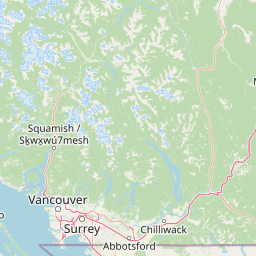
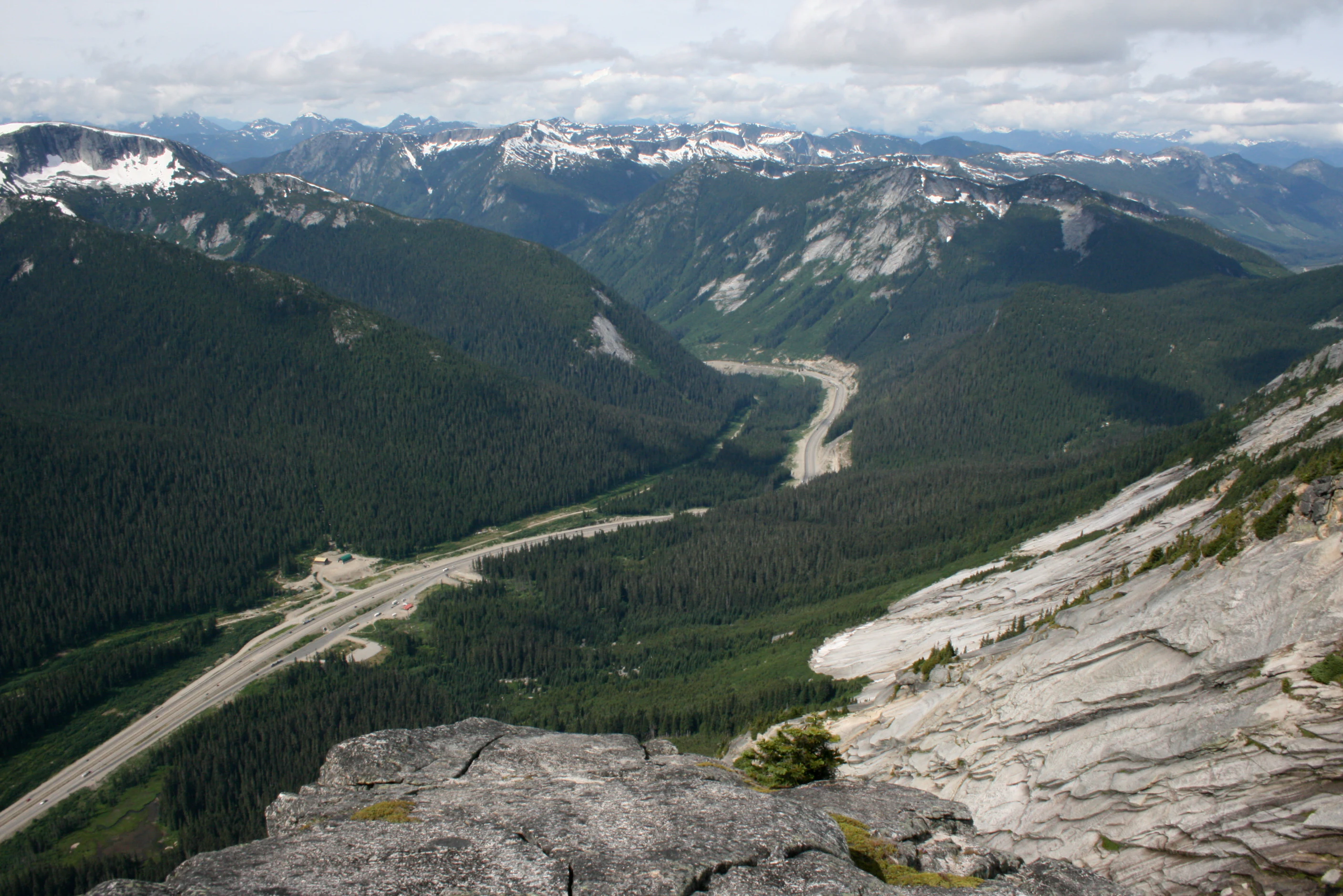
The landscape of Coquihalla Summit Recreation Area is shaped by the rugged topography of the North Cascades in southern British Columbia. Elevations in and around the recreation area rise from the floor of the Coquihalla Valley up toward craggy granite summits, creating dramatic vertical relief across the protected area's 5,750 hectares. The summit itself sits near 1,244 metres, anchoring a transition between the steep valley walls and the higher, more exposed ridges that extend northeast toward Coquihalla Lakes.
Forested mountain slopes dominate much of the recreation area, intermixed with rock outcrops, avalanche paths, and subalpine open ground at higher elevations. The steep southern approach to the summit, in particular, is one of the more pronounced ascents along the Coquihalla Highway, shaping both the visual experience of the drive and the ecological conditions within the protected area.
Portia Peak and Thar Peak are among the named summits visible from and within the recreation area, contributing to the area's skyline character. The interplay of forest, granite, and high mountain terrain creates a landscape that feels distinctly alpine despite its location along a high-speed transportation corridor.
Coquihalla Summit Recreation Area ecosystems, habitats, and plant life
Coquihalla Summit Recreation Area protects a forested mountain environment that occupies an important biogeographic boundary. Its slopes span the transition between the wet, temperate forests influenced by the British Columbia coast and the drier conifer-dominated woodlands typical of the southern interior. This overlap creates ecological conditions where plant communities from both zones can mingle, giving the area elevated biodiversity interest relative to similarly sized sites in deeper coastal or interior settings.
The steep terrain produces a variety of microclimates, with shaded north-facing slopes, exposed ridges, and valley draws each supporting different vegetation patterns. The mix of forest cover, rock, and open ground provides habitat diversity that supports a range of wildlife species, including species that depend on the continuity of forested mountain corridors as well as those adapted to the harsher conditions at higher elevations.
The recreation area's connectivity to the larger North Cascades ecosystem is also ecologically important. By protecting a large block of forest and rugged terrain along the Coquihalla corridor, it contributes to the broader network of habitats that link the coast and interior of southwestern British Columbia.
Coquihalla Summit Recreation Area wildlife and species highlights
The forested slopes and varied terrain of Coquihalla Summit Recreation Area provide habitat for wildlife typical of British Columbia's mountain transition zones. Large mammals associated with the broader Cascades region are present in and around the recreation area, and the combination of forest cover and rocky high ground supports species that range across both the coastal and interior sides of the watershed divide.
Because the recreation area lies along a major transportation corridor, it also functions as a viewing area for travellers interested in the wildlife of the upper Coquihalla Valley. The mix of dense forest and open slopes creates opportunities to observe animal movement between habitats, and the protected status of the surrounding landscape helps maintain the kind of habitat continuity that large-ranging species require to persist in a heavily travelled valley.
Coquihalla Summit Recreation Area conservation status and protection priorities
Coquihalla Summit Recreation Area was established with an explicit conservation purpose: to protect the transition zone between British Columbia's wetter coastal region and its drier southern interior. By securing roughly 5,750 hectares of forested mountain terrain along the Coquihalla corridor, the protected area helps maintain ecological connectivity between these two climatic zones in a part of the province where development pressures from roads, recreation, and forestry have historically been intense.
Designating the area in 1987, shortly after the Coquihalla Highway opened, reflected a deliberate effort to pair transportation infrastructure with landscape protection. The recreation area's conservation role is closely tied to its position as one of a series of protected sites along the new highway, which together form a chain of habitat anchors across the valley.
The area also has practical conservation significance because of the climate transition it spans. Forests at this elevation and latitude can be particularly sensitive to disturbance, and protecting a representative block of this transitional mountain environment is considered important for long-term ecological resilience in southwestern British Columbia.
Coquihalla Summit Recreation Area cultural meaning and human context
The cultural context of Coquihalla Summit Recreation Area is grounded in the long history of the Coquihalla Valley as a travel corridor. The Stó:lō people, whose Halq'emeylem language gives the area its name, have deep connections to the Coquihalla River and surrounding landscape. The name itself, rendered as _Kw'ikw'iya:la_, refers to a fishing rock near the mouth of the river and reflects traditional knowledge about the behaviour of the river and the salmon it supports.
Euro-Canadian use of the valley expanded in the late 19th century with the Hope-Nicola Trail and later the Kettle Valley Railway, both of which established the route as a vital commercial and transport link between the coast and the interior. Remnants of the Kettle Valley Railway grade remain within and near the recreation area, and parts of the broader rail corridor, including the Othello Tunnels, are now part of the Trans-Canada Trail network.
The modern Coquihalla Highway, opened in 1986, is the latest chapter in this long story of corridor development, and the establishment of the recreation area in 1987 reflected an effort to acknowledge and preserve the cultural and historical layers of the route alongside its natural values.
Top sights and standout views in Coquihalla Summit Recreation Area
Coquihalla Summit Recreation Area stands out for combining three distinct values in a single protected landscape: ecological transition, dramatic mountain scenery, and layered transportation heritage. Its location on one of southern British Columbia's most travelled mountain passes makes it unusually accessible, while its 5,750-hectare footprint ensures that the surrounding forested slopes and granite peaks retain a strong measure of ecological integrity.
The area's role as a buffer between coastal and interior climate zones gives it a conservation profile that more typical lowland sites cannot match, and the surviving traces of the Kettle Valley Railway and older highway alignments add a tangible cultural thread to the experience of visiting the corridor. Together, these qualities make the recreation area both a useful stop for travellers on Highway 5 and a meaningful protected landscape in its own right.
Best time to visit Coquihalla Summit Recreation Area
Seasonal conditions have a strong effect on the experience of visiting Coquihalla Summit Recreation Area. Summer generally offers the most comfortable conditions for stopping along the highway and taking in views from the recreation area's pullouts and short trails, when snow has receded from most viewpoints and the surrounding granite peaks are most fully visible.
Winter transforms the same landscape into a much harsher environment, with significant snowfall affecting both scenery and road conditions. Major storm events can trigger avalanche control along the Coquihalla Highway, and travellers should expect a very different, more constrained experience during the colder months. Shoulder seasons can offer quieter visits but also carry a higher likelihood of mixed weather at this elevation.