Mori Atlas logo
Wildlife reserveDarke Range Conservation Park

Mapped terrain, peppermint gum woodland distribution, and protected regional habitat context.

Darke Range Conservation Park: An Essential Wildlife Reserve on the Central Eyre Peninsula

Darke Range Conservation Park serves as a crucial protected sanctuary within South Australia, preserving rare peppermint gum woodland on the central Eyre Peninsula. The park encompasses low hills and undulating terrain, providing a natural refuge for vegetation communities that have become fragmented across the wider surrounding agricultural region. This protected area offers significant insights into the localized geography and conservation value of ridge landscapes embedded within a working rural environment.

conservation parkEyre PeninsulaSouth Australiapeppermint gum woodlandthreatened woodlandIUCN Category VI

Darke Range Conservation Park

Wildlife reserve

Park overview

Structured park overview, official facts, and landscape profile for Darke Range Conservation Park

Darke Range Conservation Park park facts, protected area profile, and essential visitor context

Review the core facts for Darke Range Conservation Park, including designation, size, terrain, visitor scale, habitats, and operating context in one park-focused overview.

About Darke Range Conservation Park

Darke Range Conservation Park is one of the smaller conservation reserves within South Australia's network of protected areas, but it plays a focused and clearly defined conservation role on the Eyre Peninsula. The park straddles sections of two historical land divisions, the Hundred of Pascoe and the Hundred of Darke, and lies immediately west of the small inland town of Darke Peak, from which it takes its name and its location context.

The reserve is anchored on the Darke Range, a modest elevated landform that runs through the otherwise gently undulating and largely cleared country that characterises much of the central Eyre Peninsula. The surrounding region is dominated by broad-acre agriculture and grazing, meaning the relatively intact native vegetation retained within the park stands out as a localised stronghold of original habitat.

Proclaimed in 1985 and expanded in 2010, the park reflects a deliberate effort to maintain a representative sample of the Eyre Peninsula's native woodland communities, particularly peppermint gum woodland, in a landscape where such habitat has otherwise been heavily modified. Its IUCN Category VI status indicates that, alongside its conservation role, the area is recognised as supporting sustainable use of natural resources consistent with its protected goals.

Quick facts and research context for Darke Range Conservation Park

Darke Range Conservation Park is a South Australian protected area located on the Eyre Peninsula near the town of Darke Peak. It was proclaimed on 28 November 1985 under the National Parks and Wildlife Act 1972 and is managed by the Department for Environment and Water.

The park covers roughly 6.93 square kilometres across portions of the Hundred of Pascoe and the Hundred of Darke, with additional land added in 2010. It is classified as an IUCN Category VI protected area, recognising its role in conserving natural values while permitting compatible land use.

Protection and recognition

Documented terrestrial protection scope and conservation designation records.

Darke Range Conservation Park Protection Status and Mapped Geography

Darke Range Conservation Park maintains a documented terrestrial protection scope within the regional conservation network. Structured records outline the official protected area designation and management framework for this landscape.

Protection details

Protection scope
Terrestrial
Transboundary protection
No
Park context

Deeper park guide and search-rich context for Darke Range Conservation Park

Darke Range Conservation Park history, landscape, wildlife, and travel context

Explore Darke Range Conservation Park through its history, landscape character, ecosystems, wildlife, conservation priorities, cultural context, and seasonal travel timing in a structured park guide built for atlas discovery and search intent.

Why Darke Range Conservation Park stands out

Darke Range Conservation Park is best known for protecting a stand of peppermint gum woodland on the Darke Range, a habitat type that is nationally threatened and considered unusual for the locality. The park was specifically expanded to safeguard this woodland, along with other threatened ecosystems and species unique to the central Eyre Peninsula.

Darke Range Conservation Park history and protected-area timeline

Darke Range Conservation Park was proclaimed on 28 November 1985 under South Australia's National Parks and Wildlife Act 1972. The initial proclamation covered land in section 116 of the Hundred of Pascoe and section 58 of the Hundred of Darke, both immediately west of the Darke Peak town centre, taking its name from the Darke Range on which it sits.

In 2010 the park was expanded, with adjoining land in the Hundred of Darke added to its north on 23 September. The addition was justified explicitly on conservation grounds, with the official purpose recorded as protecting threatened ecosystems and species unique to the locality, together with the nationally threatened peppermint gum woodland. This expansion signalled an ongoing effort to consolidate and strengthen the protection of regionally significant habitat fragments within the park's footprint.

Darke Range Conservation Park landscape and geographic character

The park lies on the Darke Range, a low, rounded elevated landform that rises gently above the surrounding country of the central Eyre Peninsula. The terrain is characterised by subdued hills and undulating ground typical of the region, framed in a broader landscape largely cleared for farming and pastoral use.

At this relatively small scale, the range provides a natural refuge of intact native vegetation in a setting where most comparable ridge and hill country has been converted to agricultural land. The park's location, close to the small service town of Darke Peak, gives the reserve a sense of being a localised pocket of natural landscape embedded within a working rural region.

Darke Range Conservation Park ecosystems, habitats, and plant life

Darke Range Conservation Park protects a representative section of the vegetation communities that once extended more widely across the Darke Range and surrounding parts of the central Eyre Peninsula. Its most significant ecological asset is a stand of peppermint gum woodland, a vegetation type that has become nationally threatened due to historical clearing, degradation, and the ongoing pressures of agricultural land use.

The park also supports other native plant communities associated with the Darke Range's soils and landforms, forming part of a broader set of threatened ecosystems and species identified as unique to the locality. By retaining these vegetation types in a consolidated block, the park helps maintain ecological continuity and provides a refuge for the native flora of the region amid a heavily modified surrounding landscape.

Darke Range Conservation Park wildlife and species highlights

While the conservation park is primarily recognised for its vegetation values, the protected habitat it sustains also provides refuge for native fauna associated with the remaining woodland and shrubland communities of the central Eyre Peninsula. The retention of peppermint gum woodland, in particular, offers structural habitat for woodland-dependent species in a region where such habitat has been substantially reduced.

Darke Range Conservation Park conservation status and protection priorities

Darke Range Conservation Park has clear and well-documented conservation significance. It was established specifically to protect native vegetation on the Darke Range, and its 2010 expansion was justified on the basis of safeguarding threatened ecosystems and species unique to the locality, alongside nationally threatened peppermint gum woodland.

Classified as an IUCN Category VI protected area, the park represents a model of conservation on a small scale: a defined, legally protected envelope of native habitat within a working agricultural landscape. Its value lies less in its size than in the rarity of the habitat it preserves at a regional and national level, helping to maintain a foothold for threatened woodland types and associated biodiversity on the Eyre Peninsula.

Darke Range Conservation Park cultural meaning and human context

The park lies within the historical Hundreds of Darke and Pascoe, land divisions inherited from South Australia's early surveying and settlement era, and is closely associated with the small rural community of Darke Peak. Its establishment reflects the ongoing relationship between regional South Australian communities and the protection of remnants of native vegetation that remain within heavily cleared farming country.

Top sights and standout views in Darke Range Conservation Park

The park's standout feature is its peppermint gum woodland, a nationally threatened vegetation type that gives the reserve its primary conservation justification.

Equally notable is the park's role as a consolidated pocket of intact native habitat on the central Eyre Peninsula, embedded within an otherwise heavily cleared rural landscape, and its clear institutional pathway from 1985 proclamation to 2010 expansion in response to documented ecological threats.
Monthly climate preview

Track monthly temperature ranges and precipitation averages across the protected landscape

Darke Range Conservation Park Climate Normals and Annual Temperature Patterns

Darke Range Conservation Park records long term temperature measurements spanning from mild winter lows to high summer maximums alongside low monthly precipitation rates. Reviewing the complete twelve month weather profile provides comprehensive insight into the representative coordinate climatology.
Annual mean17 °C
10 °C24 °C
Jan24°
Feb24°
Mar21°
Apr17°
May14°
Jun11°
Jul10°
Aug11°
Sep14°
Oct17°
Nov20°
Dec22°
Warmest month
January

23.8 °C

Coolest month
July

10.1 °C

Wettest month
June

1.3 mm/day

Driest month
January

0.5 mm/day

Park location guide

Geography guide, regional context, and park location map for Darke Range Conservation Park

Darke Range Conservation Park park geography, regions, and map view in Australia

Understand where Darke Range Conservation Park sits in Australia through a broader geographic reading of the surrounding landscape, nearby location context, and its mapped position within the national park landscape.

How Darke Range Conservation Park fits into Australia

Australia is a constitutional monarchy and federal parliamentary democracy comprising six states and ten territories. With a population of nearly 28 million, it is one of the world's most urbanised countries, with most people concentrated on the eastern seaboard. The country has a high Human Development Index and is known for its cultural diversity, ancient Aboriginal heritage, and unique wildlife.

Wider geography shaping Darke Range Conservation Park in Australia

Australia occupies the entire Australian continent, the island of Tasmania, and numerous smaller islands. It is the world's flattest and driest inhabited continent, featuring vast deserts in the interior (the Outback), tropical rainforests along the eastern coast, and a coastline bordering the Indian and Pacific Oceans.

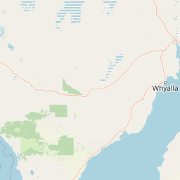
Map view of Darke Range Conservation Park

Use this park location map to pinpoint Darke Range Conservation Park in Australia, understand its exact geographic position, and read its mapped placement within the surrounding landscape more clearly.

Pigeon | © OpenStreetMap contributors

Location context for Darke Range Conservation Park

South Australia
Recorded earthquake history

Examine the Recorded Earthquake History for Darke Range Conservation Park

MoriAtlas provides a structured view of historical seismic events associated with the location of Darke Range Conservation Park. Review documented event metrics and location proximity to understand the broader seismic record of this South Australian landscape.

Darke Range Conservation Park Earthquake History

Catalogued events

1 event

Strongest magnitude

Magnitude 4.7

Most recent event

Jun 5, 2010

This history includes earthquakes recorded inside the park or within 50 km of its borders

Park atlas

Compare nearby protected landscapes and regional woodland reserves across the Eyre Peninsula

Other Parks Near Darke Range Conservation Park and Surrounding Regional Protected Areas

Browse protected areas near Darke Range Conservation Park to examine similar regional woodland reserves and undulating terrain. Continuing the geographic comparison reveals broader ecological patterns across the semi-arid central Eyre Peninsula landscape.
Nature reserveSouth Australia
About 8.2 km away#1 closest

Northeast

Carappee Hill Conservation Park: Atlas and Geographic Protected Area Profile

Nature reserve geography and Eyre Peninsula landscape context

Carappee Hill Conservation Park covers 8.5 square kilometres of rocky, elevated terrain in the locality of Darke Peak. As a designated conservation area and IUCN Category III site, it serves as a critical refuge for native vegetation, providing a clear map of protected landform heritage in central South Australia.

Area
8.5 km²
Established
1973
IUCN
III
Relief
Upland
A pale, abstract watercolor painting showing rolling green hills, trees, and a light sky against a white background.
Nature reserveSouth Australia
16 km away#2 closest

North

Caralue Bluff Conservation Park: A Protected Nature Reserve on the Eyre Peninsula

Mapping regional landscape integrity in South Australia

Caralue Bluff Conservation Park encompasses a 21.5 square kilometre tract of land in South Australia, acting as a crucial element of the Eyre Peninsula landscape. Named for the nearby Caralue Bluff landform, this nature reserve safeguards essential bushland habitats within a highly developed rural setting. Analyze the park boundaries and terrain characteristics to better appreciate its function as a conserved natural refuge.

Area
21.57 km²
Established
1993
IUCN
VI
Scope
Terrestrial
Wildlife reserveSouth Australia
About 32 km away#3 closest

East

Heggaton Conservation Park: A Protected Wildlife Reserve on the Eyre Peninsula

Mapping the semi-arid mallee woodlands of South Australia

Heggaton Conservation Park is a key wildlife reserve in South Australia that safeguards extensive mallee forest and Melaleuca shrubland. This protected area provides an essential, relatively undisturbed habitat for Malleefowl and various rare plant species within the broader Eyre Peninsula landscape.

Area
64.76 km²
Established
1993
IUCN
VI
Relief
Lowland
Wildlife reserveSouth Australia
56 km away#4 closest

Southwest

Hincks Conservation Park: Protected Wildlife Reserve in South Australia

Mapping regional biodiversity and conservation landscapes

Hincks Conservation Park functions as a key protected area within the semi-arid coastal hinterland of the Eyre Peninsula. This reserve preserves an essential fragment of native vegetation against a surrounding backdrop of agricultural development. The site highlights the importance of managed land corridors in maintaining ecological connectivity across the central-eastern reaches of South Australia.

Area
8.78 km²
Established
1941
IUCN
VI
Relief
Lowland
State or regional parkSouth Australia
About 64 km away#5 closest

Northwest

Corrobinnie Hill Conservation Park: Mapped Protected Landscapes and Geological Features

A remote conservation site on the Eyre Peninsula

Corrobinnie Hill Conservation Park protects an exceptional granite outcrop that stands as a natural monument within the South Australian landscape. The site is characterized by its weathered rock formations and its geographic connection to the broader Pinkawillinie conservation estate, offering insight into the geological diversity of remote Eyre Peninsula pastoral country.

Area
2.08 km²
Established
1983
IUCN
III
Relief
Upland
A horizontal watercolor illustration of a coastal landscape with pale pink water, green marshy shorelines, and distant soft blue hills against a white background.
Nature reserveSouth Australia
71 km away#6 closest

Southeast

Franklin Harbor Conservation Park: Coastal Nature Reserve and Eyre Peninsula Protected Geography

Coastal conservation park and island habitat system in South Australia

This nature reserve protects rare mangrove and samphire flat associations along the eastern coast of the Eyre Peninsula. The geography encompasses a sheltered peninsula and four islands within the harbor, forming an essential maritime habitat for seabirds and reptiles in the South Australian coastal landscape.

Area
13.56 km²
Established
1976
IUCN
Ia
Relief
Lowland
Wildlife reserveSouth Australia
About 78 km away#7 closest

West

Dakalanta Sanctuary: A Private Wildlife Reserve on the Northern Eyre Peninsula

Mapped regional geography and conservation habitat profiles

Dakalanta Sanctuary provides a significant example of private land conservation in South Australia. Covering 130 square kilometres of low hills and stabilized dunes, this reserve focuses on restoring native vegetation after past pastoral use. The area is vital for safeguarding semi-arid habitats like mallee woodlands, playing an active role in regional biodiversity protection and habitat connectivity.

Area
130 km²
Established
2002
Relief
Upland
Access
Access unknown
National parkSouth Australia
79 km away#8 closest

Northwest

Gawler Ranges National Park: South Australia's Mapped Protected National Landscape

Explore the geography and protected area context of this national park.

Gawler Ranges National Park stands as a significant protected area within the geographic expanse of South Australia. Designated as a national park, it offers valuable insights into Australia's conservation landscapes and regional geography. Users can explore its mapped boundaries and understand its unique role within the national park system, making it a key point for structured geographic study and atlas-based discovery of protected lands.

Area
1,628.75 km²
Established
2002
IUCN
VI
Relief
Mountain

Common questions about visiting, size, designation, and location context for Darke Range Conservation Park

Darke Range Conservation Park FAQs for park facts, access, geography, and protected area context

Find quick answers about Darke Range Conservation Park, including protected-area facts, park geography, trail and visitor context, and how the park fits into its surrounding country and regional landscape.
MoriAtlas Explorer

Continue Your Protected Areas Search Across the Global Atlas

Deepen your exploration by continuing the structured search for national parks and protected areas worldwide. Utilize the comprehensive filtering capabilities to compare different conservation landscapes and refine your understanding of global park geography. Discover more about the distribution and characteristics of protected natural areas.

Global natural geography