Why Denetiah Provincial Park and Protected Area stands out
Denetiah is recognized primarily for protecting a vast, roadless expanse of northern British Columbia wilderness at the headwaters of two important river systems. Its defining landscape features are the long, narrow, glacially carved Dall and Denetiah Lakes, which anchor the hydrology of the park and give the protected area much of its distinctive geographic character. The park is also notable as one of the cornerstones of the Muskwa-Kechika Management Area, one of the largest integrated land-use frameworks in North America, linking conservation with surrounding wilderness values across the Stikine and northern Rocky Mountain regions.
Denetiah Provincial Park and Protected Area history and protected-area timeline
Denetiah Provincial Park and Protected Area was formally established on June 29, 1999, by the Province of British Columbia through BC Parks. Its creation reflected a growing recognition of the need to protect the headwater landscapes of the Denetiah and Dahl (Dall) Rivers, along with the glacial lake systems that define the area, from expanding resource development pressures in northern British Columbia.
The park's designation was also shaped by the parallel development of the Muskwa-Kechika Management Area, a major land-use initiative designed to balance conservation with other uses across a vast stretch of northeastern British Columbia. By integrating Denetiah into this broader management framework, the province sought to ensure coordinated stewardship between the park and the surrounding constellation of parks and protected areas, recognizing that the park's ecological values extend well beyond its official boundaries.
Historically, access to the Denetiah region has relied on the Davie Trail, a long-established route used by trappers, prospectors, and outfitters traveling on foot or horseback. The absence of road infrastructure, combined with the park's remote northern location, has shaped both its history of low-intensity human use and its modern identity as one of British Columbia's most pristine wilderness reserves.
Denetiah Provincial Park and Protected Area landscape and geographic character
Denetiah's landscape is defined by a sweeping mosaic of northern boreal and sub-boreal terrain typical of the Stikine Region's interior. The terrain encompasses forested plateaus, river valleys, and rocky uplands characteristic of the transition zone between British Columbia's northern mountain systems and the broader interior plateau.
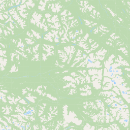
The most visually and ecologically defining features of the park are Dall Lake and Denetiah Lake, both long and narrow in form, products of glacial scouring by Pleistocene ice sheets. These lakes occupy deep, elongated basins whose orientation reflects the directional movement of ancient glaciers, and they serve as the upstream anchors for the park's two principal river systems.
The Denetiah and Dahl (Dall) Rivers both rise within the park, their headwaters branching through a network of valleys and forested slopes that gradually broaden downstream. The resulting geography; long lakes, steep-sided valleys, and remote uplands, gives the park a strongly linear, drainage-driven structure that has remained largely untouched by road-building or major infrastructure development.
Denetiah Provincial Park and Protected Area ecosystems, habitats, and plant life
Denetiah protects a substantial and ecologically significant portion of northern British Columbia's boreal and sub-boreal environment. The park's ecosystems include mature coniferous forests, muskeg and wetland complexes, riverine corridors, and the cold, oligotrophic waters of its glacially carved lakes, all of which contribute to a landscape with strong ecological integrity.
Because the park sits at the headwaters of two river systems, its ecological role extends well beyond its boundaries. The protection afforded to the upper Denetiah and Dahl (Dall) watersheds supports natural hydrological regimes, sediment processes, and water chemistry across a far wider downstream area. The combination of lake, river, forest, and wetland habitats creates a diverse matrix that supports a range of boreal-adapted species and ecological processes typical of the broader Muskwa-Kechika region.
The absence of roads and the limited history of industrial activity within the park have preserved a relatively undisturbed ecological condition, making Denetiah an important reference area for understanding the natural character of northern interior British Columbia.
Denetiah Provincial Park and Protected Area wildlife and species highlights
The park's combination of boreal forest, wetland, lake, and riverine habitats supports wildlife communities characteristic of northern British Columbia's interior wilderness. Large mammals associated with the broader Muskwa-Kechika region, including moose, caribou, elk, black and grizzly bears, and wolves, are part of the expected fauna of the area, along with furbearers and smaller mammals typical of sub-boreal environments.
The lakes and river systems within Denetiah provide habitat for fish species adapted to cold northern waters, while the surrounding forests and wetlands support a rich suite of breeding and migratory birds. The park's roadless condition and its position within a larger landscape of connected wilderness contribute to its value as habitat for wide-ranging species that depend on extensive, unmodified landscapes for their long-term persistence.
Denetiah Provincial Park and Protected Area conservation status and protection priorities
Denetiah Provincial Park and Protected Area was explicitly created to safeguard a large block of pristine wilderness at the headwaters of the Denetiah and Dahl (Dall) Rivers. By placing roughly 105,000 hectares of forested terrain, lake systems, and upper watersheds under formal protection, the park secures ecological values that extend far downstream into the broader Stikine drainage.
Its integration into the Muskwa-Kechika Management Area significantly amplifies its conservation importance. The Muskwa-Kechika framework is designed to coordinate land-use decisions across more than a dozen protected areas and surrounding lands, linking conservation with responsible use across a vast northern landscape. Denetiah serves as one of the anchor reserves within this network, helping ensure that headwater ecosystems, wildlife movement corridors, and natural disturbance regimes are maintained at a landscape scale.
The park's roadless character further enhances its conservation value, preserving a relatively unmodified ecological condition that is increasingly rare in accessible parts of southern and central British Columbia. Together, these qualities make Denetiah an important asset for long-term biodiversity conservation, wilderness preservation, and ecological research in Canada's north.
Denetiah Provincial Park and Protected Area cultural meaning and human context
The Denetiah region carries a long tradition of light, low-intensity human use rooted in the practices of northern Indigenous peoples, trappers, prospectors, and outfitters who traversed the Stikine interior on foot and horseback. The Davie Trail, the principal historical access route, reflects this older travel and trade culture, in which remote valleys were reached by long徒步 or pack-horse expeditions rather than by road.
This legacy of trail-based travel continues to shape how the landscape is understood and experienced today. The absence of road infrastructure means that encounters with the park still occur through the same modes of travel; boat, helicopter, foot, or horseback; that have historically defined human presence in this part of British Columbia. The result is a protected area whose cultural identity is closely intertwined with the traditions of wilderness expedition travel in the Canadian north.
Top sights and standout views in Denetiah Provincial Park and Protected Area
Among Denetiah's most distinctive features are the long, narrow, glacially carved Dall and Denetiah Lakes, which define the park's central geography and anchor its hydrological importance. The protected headwaters of both the Denetiah and Dahl (Dall) Rivers further elevate the park's significance, securing the upstream sources of two river systems that extend well beyond the park boundaries.
Equally important is the park's role as a roadless wilderness anchor within the Muskwa-Kechika Management Area, one of North America's largest integrated land-use and conservation frameworks. The combination of pristine boreal forest, glacial lake systems, intact watersheds, and absence of road infrastructure gives Denetiah a strong identity as a benchmark for northern wilderness conservation in British Columbia.
Best time to visit Denetiah Provincial Park and Protected Area
Because Denetiah is a roadless, expedition-style wilderness park, seasonal conditions strongly shape the experience. The short northern summer offers the most practical window for hike-in, horseback, or boat-based travel, with longer daylight hours, snow-free low-elevation terrain, and more favorable conditions on the Davie Trail and the park's lakes and rivers.
Winter brings deep snow cover, extreme cold, and very limited daylight, transforming the park into a setting suited only for highly experienced winter travelers with appropriate skills and equipment. Shoulder seasons can be unpredictable, with freeze-thaw cycles, high water levels during snowmelt, and challenging trail conditions. For most visitors, planning around the brief boreal summer aligns best with safe and rewarding access to the park's remote landscapes.