

Mori Atlas logo
Nature reserveGladys Lake Ecological Reserve

Mapping the natural terrain and ecological boundaries of northern British Columbia

Gladys Lake Ecological Reserve: A Significant Protected Wilderness on the Spatsizi Plateau

Gladys Lake Ecological Reserve serves as a primary scientific reference site within the rugged Spatsizi Plateau of north-central British Columbia. Spanning over 44,000 hectares of largely undisturbed alpine and subalpine terrain, the reserve captures the transition between high ridges and interior highlands. It stands as a vital example of northern Canadian wilderness where strict conservation preserves the natural state of complex mountain ecosystems.

ecological reservestrict nature reservealpine ecosystemssubalpine wildernessSpatsizi Plateauremote wilderness

Gladys Lake Ecological Reserve

Nature reserve

Park overview

Structured park overview, official facts, and landscape profile for Gladys Lake Ecological Reserve

Gladys Lake Ecological Reserve park facts, protected area profile, and essential visitor context

Review the core facts for Gladys Lake Ecological Reserve, including designation, size, terrain, visitor scale, habitats, and operating context in one park-focused overview.

About Gladys Lake Ecological Reserve

Gladys Lake Ecological Reserve is one of the most important protected areas in British Columbia for ecological research and wilderness preservation in the northern interior of the province. Situated in the Eaglenest Range of the Spatsizi Plateau, the reserve lies in a region characterized by wide plateaus, rugged subalpine ridges, and remote valleys that have remained largely untouched by industrial development. The reserve's establishment under the Ecological Reserves Act in 1975 reflects a deliberate conservation decision to set aside a representative sample of these northern alpine environments for long-term scientific study.

Unlike most parks in British Columbia that balance recreation and conservation, Gladys Lake is managed as an IUCN Category Ia strict nature reserve. This designation signals that the primary purpose of the reserve is to maintain natural ecosystems and ecological processes in as undisturbed a state as possible. Public recreation is actively discouraged, and access is tightly controlled, which reinforces the reserve's role as a benchmark site for understanding pristine northern plateau conditions.

Although the reserve is entirely enclosed within Spatsizi Plateau Wilderness Provincial Park, its protections are considerably stricter than those of the surrounding provincial park. The result is a layered conservation landscape in which a major wilderness park surrounds, and buffers, an even more tightly protected scientific reserve. This arrangement highlights the value placed on the Spatsizi Plateau as one of the most ecologically significant regions in British Columbia, and underscores why Gladys Lake stands out as a flagship example of the province's ecological reserve program.

Quick facts and research context for Gladys Lake Ecological Reserve

Gladys Lake Ecological Reserve is located in the Eaglenest Range of the Spatsizi Plateau in north-central British Columbia and covers about 44,098 hectares. It was established in 1975 under British Columbia's Ecological Reserves Act and is managed by BC Parks as an IUCN Category Ia strict nature reserve. The area exists as an enclave within Spatsizi Plateau Wilderness Provincial Park, but with substantially tighter protections and limited public access.

Protection and recognition

Documented terrestrial protection scope and recognized conservation framework

Gladys Lake Ecological Reserve Protection Status and Governance Data

Gladys Lake Ecological Reserve maintains a designated terrestrial protection scope within its registered regional boundary. Structured conservation records outline the official management framework and documented administrative status.

Protection details

Protection scope
Terrestrial
Transboundary protection
No
Park context

Deeper park guide and search-rich context for Gladys Lake Ecological Reserve

Gladys Lake Ecological Reserve history, landscape, wildlife, and travel context

Explore Gladys Lake Ecological Reserve through its history, landscape character, ecosystems, wildlife, conservation priorities, cultural context, and seasonal travel timing in a structured park guide built for atlas discovery and search intent.

Why Gladys Lake Ecological Reserve stands out

Gladys Lake is best known as the largest ecological reserve in British Columbia, protecting a vast area of remote alpine-subalpine wilderness on the Spatsizi Plateau. Its significance lies less in visitor attractions and more in its role as an undisturbed scientific reference site where ecological processes can be studied with minimal human interference. The combination of its size, remoteness, and strict protection status defines its identity more than any single landmark feature.

Gladys Lake Ecological Reserve history and protected-area timeline

Gladys Lake Ecological Reserve was formally established in 1975 under British Columbia's Ecological Reserves Act. The reserve was created specifically to support scientific research of the alpine-subalpine ecosystems of the Spatsizi Plateau while minimizing recreational pressure that could otherwise affect the area's wilderness character.

Its designation as an IUCN Category Ia strict nature reserve reflects an explicit policy decision to emphasize ecological preservation and research over visitor access. Over time, the reserve has come to be recognized as the largest ecological reserve in British Columbia, a reflection of both the scale of the landscapes it protects and the importance British Columbia has placed on safeguarding representative samples of its northern interior ecosystems.

Gladys Lake Ecological Reserve landscape and geographic character

The reserve is set within the Eaglenest Range of the Spatsizi Plateau, a vast and remote region of north-central British Columbia. The terrain is characterized by high plateaus, subalpine ridges, and rugged valleys typical of the northern interior highlands. Elevation, isolation, and a lack of road access have all contributed to keeping the land in a largely natural state.

The landscape surrounding Gladys Lake is dominated by the broad physiographic character of the Spatsizi Plateau, with open alpine expanses interspersed with rocky ridges and sheltered valleys. The reserve sits at the heart of this plateau country, capturing the transition zones between subalpine forest and open alpine environments that define the region's natural character.

Gladys Lake Ecological Reserve ecosystems, habitats, and plant life

Gladys Lake Ecological Reserve protects a substantial block of alpine and subalpine ecosystems in the Spatsizi Plateau. The reserve's ecological value lies in its role as a relatively undisturbed representation of the kind of high-elevation habitats found across north-central British Columbia, including gradients from subalpine forest to open alpine tundra.

Because the reserve was established specifically to support scientific research of regional ecosystems, the management framework prioritizes maintaining natural conditions and ecological processes rather than public interaction with the land. The climate, elevation, and isolation of the plateau combine to produce habitats shaped by long winters, short growing seasons, and minimal direct human disturbance.

Gladys Lake Ecological Reserve conservation status and protection priorities

Ecologically, Gladys Lake is significant as the largest ecological reserve in British Columbia and as a core element of the province's ecological reserve network. Its designation as an IUCN Category Ia strict nature reserve gives it one of the highest levels of formal protection available in the province, focused on preserving natural ecosystems and ecological processes for research and long-term monitoring.

The reserve's location as an enclave within Spatsizi Plateau Wilderness Provincial Park adds a second layer of conservation, surrounding a strictly protected scientific core with a broader wilderness buffer. Together, this arrangement strengthens the protection of a large, contiguous area of northern interior wilderness, while the reserve itself serves as a benchmark for understanding what minimally disturbed Spatsizi Plateau ecosystems look like.

Top sights and standout views in Gladys Lake Ecological Reserve

Gladys Lake Ecological Reserve's standout qualities lie in its size, its remoteness, and the strictness of its protection. As the largest ecological reserve in British Columbia and a strict nature reserve by international standards, it represents a deliberate choice to set aside a major block of Spatsizi Plateau wilderness for science rather than recreation. Its position inside Spatsizi Plateau Wilderness Provincial Park further reinforces its conservation weight within one of the most iconic wilderness landscapes of north-central British Columbia.
Monthly climate preview

Long term representative measurements tracking annual temperature and precipitation rhythm

Gladys Lake Ecological Reserve Climate Normals and Monthly Temperature Patterns

Representative coordinate records for Gladys Lake Ecological Reserve show sustained subzero winter averages alongside moderate summer temperature peaks and measured monthly precipitation. Reviewing the complete twelve month climatology profile provides deeper analytical context for long term regional weather patterns.
Annual mean-4 °C
-14 °C9 °C
Jan-14°
Feb-13°
Mar-11°
Apr-6°
May
Jun
Jul
Aug
Sep
Oct-4°
Nov-12°
Dec-14°
Warmest month
July

8.5 °C

Coolest month
January

-14.4 °C

Wettest month
July

3.3 mm/day

Driest month
April

1.4 mm/day

Park location guide

Geography guide, regional context, and park location map for Gladys Lake Ecological Reserve

Gladys Lake Ecological Reserve park geography, regions, and map view in Canada

Understand where Gladys Lake Ecological Reserve sits in Canada through a broader geographic reading of the surrounding landscape, nearby location context, and its mapped position within the national park landscape.

How Gladys Lake Ecological Reserve fits into Canada

Canada is a federal parliamentary constitutional monarchy spanning North America from the Atlantic to the Pacific and Arctic Oceans. With a population of over 41 million, it is officially bilingual in English and French at the federal level. The country gained independence from the United Kingdom through a gradual process culminating in 1982.

Wider geography shaping Gladys Lake Ecological Reserve in Canada

Canada occupies the northern portion of North America, sharing its longest international border with the United States. The country extends from the Atlantic Ocean to the Pacific Ocean and northward into the Arctic Ocean, giving it the longest coastline of any nation.

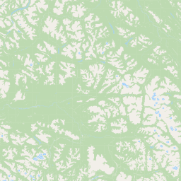
Map view of Gladys Lake Ecological Reserve

Use this park location map to pinpoint Gladys Lake Ecological Reserve in Canada, understand its exact geographic position, and read its mapped placement within the surrounding landscape more clearly.

Pigeon | © OpenStreetMap contributors

Location context for Gladys Lake Ecological Reserve

British Columbia
Park atlas

Discover connected northern interior landscapes and regional wilderness reserves.

Explore Protected Areas and Parks Near Gladys Lake Ecological Reserve

Browse adjacent wilderness reserves and protected landscapes sharing the rugged terrain of the Spatsizi Plateau. Comparing regional park geography provides deeper context into northern British Columbia conservation areas.
State or regional parkBritish Columbia
About 108 km away#1 closest

Northeast

Denetiah Provincial Park and Protected Area: Regional Geography and Wilderness Mapping

An undisturbed boreal reserve in the Stikine Region

Discover the geographic structure of Denetiah Provincial Park and Protected Area, a vast roadless landscape in northern British Columbia. This park protects pristine boreal forests, elongated glacial lake basins, and critical river headwaters that serve as a benchmark for northern conservation within the Muskwa-Kechika Management Area.

Area
1,053.49 km²
Established
1999
IUCN
II
Relief
Upland
State or regional parkBritish Columbia
About 159 km away#2 closest

East

Finlay-Russel Provincial Park and Protected Area: Mapping Northern British Columbia Wilderness

A remote river corridor in the Muskwa-Kechika Management Area.

Located in northern British Columbia, Finlay-Russel Provincial Park and Protected Area preserves an essential 85-kilometre river corridor along the Finlay River. This expansive wilderness territory serves as an integral part of the Muskwa-Kechika Management Area, showcasing deep boreal forest landscapes and rugged river valley terrain far from established road networks.

Area
1,092.05 km²
Established
2001
IUCN
II
Access
Remote access
State or regional parkBritish Columbia
About 176 km away#3 closest

Northeast

Dune Za Keyih Provincial Park and Protected Area: Watershed and Terrain Geography

Remote wilderness landscape in northern British Columbia

Dune Za Keyih Provincial Park and Protected Area protects the largest unlogged watershed in British Columbia. Situated within the Muskwa-Kechika Management Area, this remote wilderness is defined by the geological structures of the Rocky Mountain Trench, providing a continuous corridor of undisturbed mountain forest, riparian zones, and highland terrain.

Area
3,468.33 km²
Established
2001
IUCN
Ib
Relief
Mountain
State or regional parkBritish Columbia
About 177 km away#4 closest

Southwest

Lava Forks Provincial Park: Geological Mapping and Protected Area Overview

Remote volcanic wilderness in northern British Columbia

This protected area preserves the fresh geological features created by the 1904 eruption of The Volcano. The site offers a detailed look at ash dunes, lava flows, and water-filled potholes within a remote northern British Columbia setting. Use this atlas resource to examine the park boundaries and the unique terrain that characterizes this significant transboundary conservation landscape.

Area
74.63 km²
Established
2001
IUCN
III
Relief
Mountain
State or regional parkBritish Columbia
About 182 km away#5 closest

Northeast

Horneline Creek Provincial Park: Protected Canyon Landscapes and Rocky Mountain Trench Geography

Remote glacial-terrace wilderness in northern British Columbia

Located deep in the Rocky Mountain Trench, Horneline Creek Provincial Park is defined by its deep-cut canyon and ancient glacial terraces. This protected area offers an intimate view of sub-boreal terrain where mineral-stained walls and aspen-dotted grasslands create a concentrated, ecologically significant landscape within a remote corner of northern British Columbia.

Area
2.98 km²
Established
1999
IUCN
II
Relief
Upland
State or regional parkBritish Columbia
About 198 km away#6 closest

Southwest

Great Glacier Provincial Park: Glacial Geography and Protected Wilderness in Northern British Columbia

A rugged mountain landscape within the Stikine River corridor.

Great Glacier Provincial Park protects a compact, visually intense glacial environment along the Stikine River. Established to preserve the dramatic Great Glacier as it descends from the Boundary Ranges, this protected area features deep river valleys, steep mountainous slopes, and a unique ecological transition zone near the international border.

Area
93 km²
Established
2001
IUCN
II
Relief
Mountain
State or regional parkBritish Columbia
About 204 km away#7 closest

East

Kwadacha Wilderness Provincial Park: Geographic Boundaries and Regional Protected Area Context

Untouched mountain wilderness in northern British Columbia

Kwadacha Wilderness Provincial Park provides a rare, roadless mountain experience within the northeastern interior of British Columbia. Characterized by high-relief alpine ridges, dense boreal forests, and challenging river systems, the park represents an essential wilderness corridor that remains free from human infrastructure and standard road access, prioritizing ecological integrity over recreation.

Area
1,302.79 km²
Established
1973
IUCN
Ib
Relief
Mountain
A pale, minimalist watercolor painting of a river landscape with distant rolling hills, marshy grasses, and light tree clusters under a bright sky.
State or regional parkBritish Columbia
About 260 km away#8 closest

Northeast

Liard River Hot Springs Provincial Park: Boreal Geothermal Mapping and Regional Geography

Protected northern wilderness, thermal water systems, and muskeg wetland terrain

Liard River Hot Springs Provincial Park serves as a protected geographic nexus where thermal water discharge creates a unique biological oasis. The park landscape combines expansive boreal forest with sensitive muskeg wetlands, centered around a natural hot spring system that supports orchid populations and regular wildlife sightings. This atlas entry provides essential context on the physical boundaries and ecological features that define this significant regional park in northern British Columbia.

Area
10.82 km²
Established
1957
IUCN
III
Relief
Lowland

Common questions about visiting, size, designation, and location context for Gladys Lake Ecological Reserve

Gladys Lake Ecological Reserve FAQs for park facts, access, geography, and protected area context

Find quick answers about Gladys Lake Ecological Reserve, including protected-area facts, park geography, trail and visitor context, and how the park fits into its surrounding country and regional landscape.
MoriAtlas Explorer

Continue Your Protected Areas Search Across the Global Atlas

Deepen your exploration by continuing the structured search for national parks and protected areas worldwide. Utilize the comprehensive filtering capabilities to compare different conservation landscapes and refine your understanding of global park geography. Discover more about the distribution and characteristics of protected natural areas.

Global natural geography